A History of the County of Wiltshire: Volume 18. Originally published by Boydell & Brewer for Victoria County History, Woodbridge, 2011.
This free content was digitised by double rekeying. All rights reserved.
'Historic Parishes - Latton', in A History of the County of Wiltshire: Volume 18, ed. Virginia Bainbridge (Woodbridge, 2011), British History Online https://prod.british-history.ac.uk/vch/wilts/vol18/155-171 [accessed 4 April 2025].
'Historic Parishes - Latton', in A History of the County of Wiltshire: Volume 18. Edited by Virginia Bainbridge (Woodbridge, 2011), British History Online, accessed April 4, 2025, https://prod.british-history.ac.uk/vch/wilts/vol18/155-171.
"Historic Parishes - Latton". A History of the County of Wiltshire: Volume 18. Ed. Virginia Bainbridge (Woodbridge, 2011), British History Online. Web. 4 April 2025. https://prod.british-history.ac.uk/vch/wilts/vol18/155-171.
In this section
LATTON
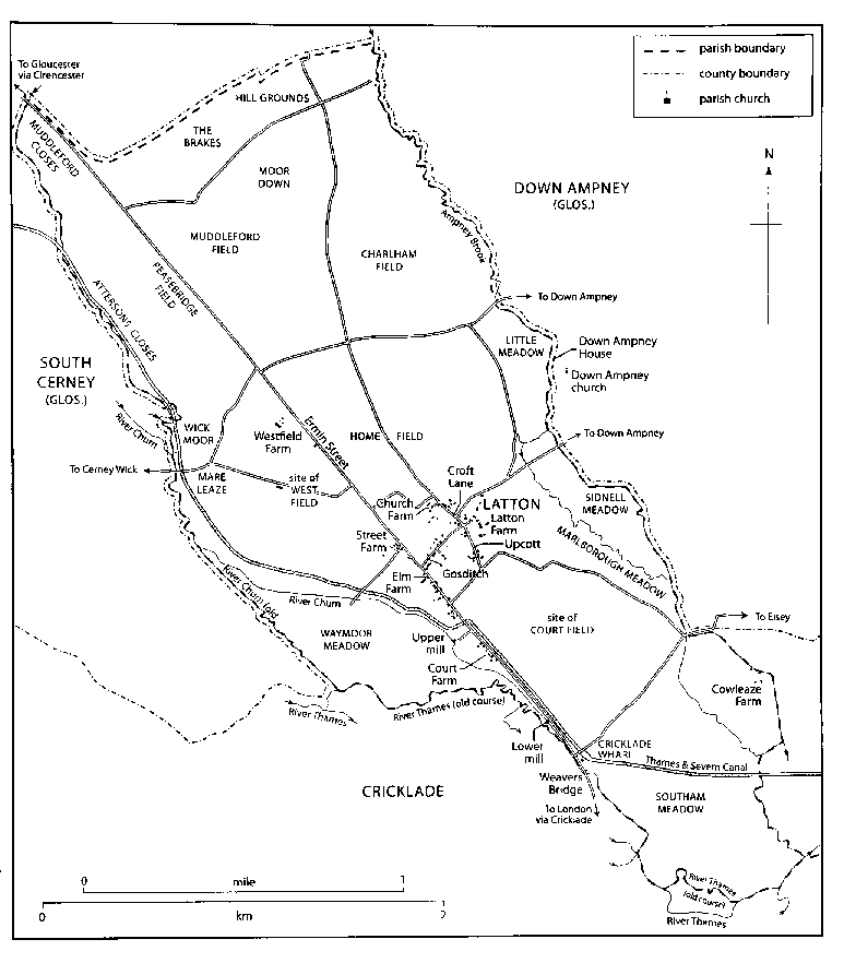
MAP 14. Latton parish at the time of inclosure, c. 1802.
LATTON until 1896 was a small parish (1,826 a., 739 ha.) on Wiltshire's ragged northern border, lying north-west and south-east, and projecting into Gloucestershire. (fn. 1) Latton village straddles an important routeway, 9.5 km. south-east of Cirencester (Glos.), 2 km. north of Cricklade, and 12.5 km. north-west of the centre of Swindon. It stands on a low, barely perceptible, ridge which runs along predominantly flat land, draining to headwaters of the upper Thames that define most of the parish boundaries. River deposits overlying clay have determined Latton's farming regimes since prehistory; and large-scale gravel extraction during the 20th century and ongoing has combined with recent highway improvements to produce a landscape of lakes and road junctions.
The estate called Latton in the 11th century, (fn. 2) the land worked from the farmsteads in Latton village, (fn. 3) and the parish of Latton church all apparently occupied the same territory. In 1896 Eisey parish was added to it, (fn. 4) increasing its area to 4,340 a. (1,756 ha.); in 1984 a transfer of land to Cricklade reduced it to 1,737 ha. (4,292 a.). (fn. 5)
Eisey's history is treated separately. (fn. 6)
Boundaries
The parish as it was until 1896 was bounded mainly by streams. Most of the boundary on the north-east (with Down Ampney, Glos., and Eisey) followed the main course of Ampney brook, and the remainder a minor course of Ampney brook and a head stream of the Thames. Straightening of these watercourses between c. 1802 and 1875 has resulted in minor discrepancies with the boundary. (fn. 7) On the south-west the boundary followed a head stream of the river Churn, the Churn itself, and the river Thames; its north-western section, also part of Wiltshire's boundary with Gloucestershire, had apparently been set by 999. (fn. 8) The diversion of the Churn to drive mills at Latton, and of the Thames to serve Cricklade and facilitate navigation, have separated the rivers from the boundary in places. (fn. 9) Stretches of Latton's boundary with St Sampson's parish, Cricklade, were also straightened c. 1802 and between 1840 and 1875 to coincide with river improvements; in 1984, when land was transferred to Cricklade parish, the boundary southeast of those straight sections was redrawn to follow a new stretch of main road built in 1975. (fn. 10) At the north-west end of Latton parish the boundary between Ampney brook and the head stream of the Churn runs as two straight lines, one of which follows a Roman road.
Landscape
The parish slopes gently from the straight boundary at its north-western end, where its highest point is at 100 m., to the Thames at its south-east end, where its lowest point is at c. 78 m. On the higher land in the north-west, including the ridge running south-east towards the village, Kellaways Clay and Kellaways Sand outcrop. Elsewhere the outcrops are overlain by river deposits mainly of gravel and, beside the streams, by alluvium. The alluvium is at its most extensive in the south corner of the parish where the Churn and the head stream flow into the Thames, and a reach of Ampney brook, straightened between 1828 and 1875, crosses the southeast corner of the parish. (fn. 11) The present main course of the Churn crosses the parish near Latton village, and minor watercourses flow to each of the boundary streams.
Land in the north-west of the parish was exploited for mixed arable and pastoral farming from the Middle Bronze Age, through the Iron Age and into the Roman period. (fn. 12) Latton's name, meaning 'farm where herbs were grown', suggests specialist cultivation of fertile land in the late Saxon period. (fn. 13) The medieval community's open fields were set out mainly on the gravel and partly on the clay, its alluvium was used as meadow land, and, in the north-west part of the parish, about half its pasture lay on clay and about half on gravel. (fn. 14) In historic times there was little woodland until the 19th century. (fn. 15) Commercial extraction of gravel began in the 20th century; in 2009 water lay in four exhausted pits, two small ones in the village worked in the earlier 20th century and two large ones north-west of the village worked from the mid 1990s. (fn. 16) The large water-filled pit was the easternmost of many lakes in the Ashton Keynes section of the Cotswold Water Park. Gravel extraction was in progress in 2009 east of Weavers Bridge.
Communications
Roads
The line of Ermin Street, the Roman road
from London to Cirencester and Gloucester via Silchester
(Hants.) and Speen (Berks.), crosses the parish southeast and north-west. (fn. 17) Trackways of probable Roman
date linked it to a settlement and fields east of Weavers
bridge. (fn. 18) Although in 2009 traffic on the road linking
London, Swindon, Cirencester, Gloucester, and
Hereford still crossed the parish, as the main road,
Ermin Street, had by then gone out of use from the
south-east in three phases.
After the Roman period, and perhaps c. 890, when Cricklade was developed as a new town, traffic was diverted off the street and through the town. Most of the section of the street which then went out of use lay at the south-east end of what was to become Latton parish, and a causeway across low lying meadow land was built to link the north end of Cricklade's main street to Ermin Street c. 100 m. north-west of what is now called Weavers Bridge. (fn. 19) On its course along this causeway and Ermin Street the main road was turnpiked in 1758 and disturnpiked in 1879. (fn. 20) As part of the main London–Hereford road via Hungerford (Berks.) it was designated a trunk road in 1946. (fn. 21)
In 1975 a new road, diverging from Ermin Street c. 500 m. north-west of the junction with the causeway, was built as a bypass for Cricklade, and traffic was thus diverted from a second section of Ermin Street; the new road ran a little north-east of the line of the street, across the south-east end of Latton parish. (fn. 22) In 1997 the rest of Ermin Street in the parish was superseded by a new section of trunk road built as a bypass for Latton village; the new road runs south-west of Ermin Street and beside it where, in the north-west, the street marks the parish boundary. Elaborate junctions with minor roads were made close to Weavers Bridge and at the north-west end of the parish in 1997. (fn. 23) In 2009 much of Ermin Street across the parish remained a well used road serving Latton village, farms and gravel working, and its presence continues to dominate the parish.
Besides Latton three villages — Down Ampney, Cerney Wick (in South Cerney, Glos.), and Eisey — were linked to Ermin Street by minor roads through Latton parish, (fn. 24) and in 1971 a new road, called Spine Road (East), was opened across the Ashton Keynes section of the Cotswold Water Park to Ermin Street at the north-west end of Latton parish. (fn. 25) Latton village was linked to Down Ampney 1 km. away by a road running north-west of Latton church and south-east of Down Ampney church. (fn. 26) In 1841, to avoid the new vicarage house at Latton, it was diverted to a course south-east of Latton church. (fn. 27) The new road served as a drive of Down Ampney House, has never been tarmacadamed, and was a public footpath in 2009. Probably from the mid 19th century travel between Latton and Down Ampney, except for those visiting Down Ampney House, (fn. 28) was via Ermin Street and the minor road north of Latton village.
Canals
The Thames and Severn canal was opened
across the parish in 1789. It was built near what was then
the main course of the Churn and had locks near
Cerney Wick and south of Latton village; it crossed
Ermin Street under a bridge and ran beside the street to
a wharf near the south-east end of the parish. The canal
carried coal from the Forest of Dean and Staffordshire;
the wharf served Cricklade and was called Cricklade
wharf in the 19th century. (fn. 29) Although the canal was not
abandoned until 1927 there was apparently little traffic
on it from the 1860s. (fn. 30) In 1975 the Cricklade bypass was
built along the line of that section of the canal which
ran beside Ermin Street. In 2009 the wharfinger's house
and, near Cerney Wick, a lock and a watchman's house
all survived. (fn. 31)
The North Wilts. canal was opened in 1819. It joined the Thames & Severn canal a little west of Latton village and linked it to the Wilts. & Berks. canal. (fn. 32) A basin, lock, aqueduct over the Churn, wharf, and what was possibly a wharfinger's house were all built on the new canal near the junction. (fn. 33) The wharf was called Latton wharf in the 19th century. (fn. 34) The canal was closed by Act in 1914, traffic on it having ceased in 1906. (fn. 35)
Population
Latton had 114 poll-tax payers in 1377, (fn. 36) an adult population of c. 156 in 1676, (fn. 37) and a population of 349 in 1801. The population had fallen to 315 by 1821 and risen to 379 by 1841. It thereafter declined and had reached 218 by 1891; between 1871 and 1891 it fell by 30 per cent. (fn. 38)
The enlarged Latton parish (augmented by Eisey) had a population of 367 in 1901 and 365 in 1921. The population increased in the mid 20th century, when new houses were built and a factory provided employment; it reached its peak at 506 in 1951. (fn. 39) From 456 in 1961 the number of inhabitants had fallen to 328 by 1981, another 30 per cent fall. New housing in Latton village in the 1980s and 1990s caused it to grow; there were 429 inhabitants in 2001. (fn. 40)
SETTLEMENT
Archaeological investigation since c. 1970 has shown that what became Latton parish was densely and repeatedly, if not continuously, settled and exploited from the Neolithic to the end of the Roman period. An oval enclosure of possible ritual significance, excavated south-west of Westfield farm, has been dated to the late Neolithic or early Bronze Age period. (fn. 41) In the northwest of the parish a middle Bronze Age settlement comprising roundhouses within a substantial ditch practised a mixed farming economy, (fn. 42) but by the early Iron Age settlement had shifted south-eastwards to at least three locations, north-west, south and south-east of Westfield Farm. (fn. 43) Abandonment or relocation to better drained ground occurred in the middle Iron Age, when three small pastoral settlements were in use, perhaps seasonally, east of Weavers Bridge. (fn. 44) Woodland clearance, coupled with a reorganisation and intensification of farming, occurred during the later Iron Age and into the Roman period, (fn. 45) and settlements were established on new sites.
Perhaps because it lies along Ermin Street equidistant between Roman towns at Cirencester and Wanborough, the area that became Latton has yielded abundant evidence of Romano-British activity, including farmsteads, field systems and occupation and building debris, including a tessellated pavement discovered c. 1670. (fn. 46) Settlements, not necessarily contemporary with each other, lay at the Roman river crossing on the Cricklade boundary, near Weavers Bridge, east of Court Farm, north-west of Street Farm, in the north of the later parish between Dukes Brake and Vines Brake, and elsewhere. (fn. 47) The Weavers Farm settlement was in use until the mid-4th century, (fn. 48) and near Street Farm a pit was excavated containing pottery, daub, bone and a loomweight datable to the early Saxon period. (fn. 49)
Latton Village
There was a settlement at Latton before 1066, when its estate was united with that of Eisey; thereafter they were administered, and often assessed, together. (fn. 50) By the 13th or 14th century Latton village probably lay as two separate parts. The church, demesne farmstead and vicarage house stood as a group c. 300 m. north-east of Ermin Street; and perhaps as many as 25-30 customarily held farmsteads and tenements almost certainly stood beside Ermin Street, c. 750 m. of which served as a village street. The building of these tenements may have been part of planned exploitation of the land and have coincided with the setting out of Latton's open fields and commonable meadows and pastures. (fn. 51) The lane linking the two parts of the village was called Gosditch in the 20th century. At its junction with Ermin Street a stone cross on a stepped base was erected probably in the 13th century. (fn. 52)
The demesne farmstead probably stood south-east of the church on the site of buildings which in the 20th century were called Church Farm. By a lease of 1532 the lessee was required to build an eight-bayed mansion house near the demesne farm buildings, (fn. 53) and a house called Latton Farmhouse was held by lease in the 17th century. (fn. 54) A house built on a regular E plan with a formal south-west garden stood c. 60 m. south-east of the church, and was demolished in the late 19th century. (fn. 55) A great barn at the site had been demolished by 1679. (fn. 56) Farm buildings there in 2009 were large and disused and included some apparently of the 19th century and some of the 20th. A church house was built c. 1540 (fn. 57) on a site which was still held on lease by the churchwardens in the mid 17th century; (fn. 58) the building may have been that which stood at the west end of the churchyard c. 1802, (fn. 59) which had been demolished by 1841, and near the site of which the village school was built in 1832. (fn. 60) The vicarage house, which in 1819 was said to adjoin the churchyard, (fn. 61) probably stood immediately east of the church. A new vicarage house was built north of the church in 1827. The old house was demolished about then, and between 1841 and 1875 a large house called the Corner was built on what was probably its curtilage. (fn. 62)
By c. 1800 settlement had extended north-west and south of the buildings near the church. (fn. 63) To the northwest a farmstead apparently built in the 17th century, possibly on an early inclosure of part of the open field called Home field which adjoined the village, (fn. 64) was called Church Farm in the 19th century; (fn. 65) on the site in 2009 were an early 19th-century farmhouse called Littlecourt, a stone barn which had been converted for residence, and dilapidated farm buildings apparently of the 19th and 20th centuries. In Croft Lane, between the farmstead and the church, an 18th-century cottage survived in 2009. To the south a small group of buildings may have been erected on waste land; the lane which led to it from the church was given the name Upcott. About six buildings stood there c. 1802, (fn. 66) including a small house with a farm yard behind it and a cottage, both built in the 18th century; they survived in 2009. (fn. 67)
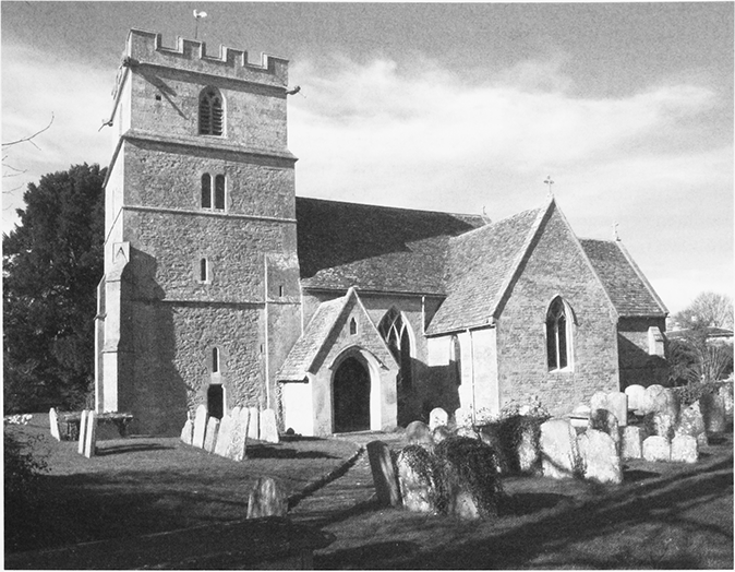
22. Parish church of St John the Baptist, from the south. It was begun in the mid 12th century.
What was almost certainly planned settlement grew up along the south-west side of Ermin Street to the south-east of the cross. A building interpreted as a detached bakehouse or kitchen associated with this settlement was excavated in advance of bypass construction, and found to have been in use from the 13th or 14th century until the mid-16th century. (fn. 68) About 1802 buildings stood on c. 10 long narrow closes which ran back from the street, perhaps originally small farmsteads, (fn. 69) most of which survived in 2009; they included Elm Farm, built of stone in the 17th century, and two stone houses which may be 18th century. On this side of the street the line of settlement may have extended north-west to Street Farm and south-east to Court Farm, each of which was largely rebuilt in the earlier 19th century. By c. 1800 the number of farmsteads in Latton had been greatly reduced, there were spaces between the main line of settlement and Street Farm and Court Farm, and there were fewer buildings on the north-east side of the street than on the south-west. (fn. 70) Most of Latton's buildings along Ermin Street were apparently farmsteads or cottages and, although they stood beside the main London–Gloucester road, few seem to have provided services to travellers: there was a smithy, (fn. 71) in the 20th century a petrol station, (fn. 72) but no inn or retail shop.
In the early Middle Ages Gosditch may have been left as a wide lane between open fields to link the church and Ermin Street. About 1802 the lane was narrow, rectangular closes lay between it and what may have been its original boundaries with the open fields, and what may have originated as small farmsteads stood on several of the closes. (fn. 73) The only building of c. 1802 to survive in 2009 was Bowron Cottage, which stands near the south-west end of Gosditch and was apparently built as a small farmhouse in the later 18th century.
In the 19th and earlier 20th centuries many buildings were demolished and some were replaced, (fn. 74) and in the later 20th century and early 21st many new ones were erected. In the 19th century, besides the new vicarage house and the Corner, three large houses were built for the middle classes: the Limes, a cottage-style villa built in Gosditch between c. 1850 and 1875; Upcott built south of the church between 1875 and 1895; and the Croft, a plain, three-bayed and two-storeyed house of the same period. The Croft was built in the north angle of Gosditch and Ermin Street in a small park with an avenue which survives.
Three pairs of estate cottages were built in Gosditch by 1875, and a row of cottages on the north-east side of Ermin Street. Between 1898 and 1920 two cottages in a row of five on the north-east side of Ermin Street were rebuilt as a pair, (fn. 75) and the other three were demolished in the 20th century. A new cottage was built in Upcott in 1902, and a pair of estate houses was built off the north-west side of Gosditch in 1932. In the earlier 20th century a few private houses were built, including one on the north-east side of Ermin Street in 1931 and a large one in Croft Lane in 1936. (fn. 76) In 1947 nine council houses were built in Limes Place off Gosditch. (fn. 77) In the later 20th century c. 20 private houses were built on individual plots, mainly in Croft Lane, Upcott, and Gosditch; and a group of four houses and a block of six flats were built off Gosditch. Residential mobile homes were parked beside two water-filled gravel pits southeast of Gosditch from the 1950s; (fn. 78) c. 20 stood there in 2009. After the bypass was completed in 1997 Ermin Street became more attractive for development and two larger groups of houses were built alongside it, 14 at Collett Place on the north-east side c. 2001, (fn. 79) and 31 on the site of the Croft, which was demolished, in 2003–4.
Other Settlement
There were two mills on the Churn, one near the village and one south-east of it; (fn. 80) otherwise there was apparently little settlement outside the village in the Middle Ages. Two farmsteads, Westfield Farm and Cowleaze Farm, had been built by 1773, (fn. 81) Westfield on open-field land inclosed early and Cowleaze on pasture inclosed early; (fn. 82) Cowleaze Farm was demolished c. 1960. (fn. 83) At the south-east end of the parish a turnpike cottage was built presumably c. 1758, altered and given a halftimbered upper storey in the later 20th century, and beside the canal the watchman's house and the wharfinger's house were built in 1789–90. (fn. 84)
Settlement in the north-west of the parish began in the early 19th century. Manor Farm was built off Ermin Street between c. 1802 and 1820; (fn. 85) by 1875 it had become a large farmstead, and a pair of houses had been built nearby. (fn. 86) On nearby sites a factory and a pumping station were built in the 1930s, (fn. 87) and in the mid 20th century three more houses were built. Beside Ermin Street four council houses were built in 1938, (fn. 88) and also in the mid 20th century eight estate houses were built beside the Down Ampney road south-east of Manor Farm and two beside Ermin Street near Westfield Farm. (fn. 89) Between c. 1802 and 1875 a cottage possibly for a gamekeeper was built beside woodland at the northwest end of the parish, and farm buildings and a pair of cottages, called Lertoll Well in 2009, were built southeast of the village. (fn. 90)
The Built Character
Medieval building work survives in the church, which stands in a large raised churchyard, and in the tapered remnant of an octagonal late 13th-century cross, which stands at the junction of Ermin Street and Gosditch. (fn. 91) In 1810 the cross stood on a base with three steps and was crowned by a ball finial. (fn. 92) It was restored in 1982, (fn. 93) incorporating part of the medieval shaft.
There are two surviving 17th-century houses. One, of one and a half storeys, was relegated to a service range of the present farmhouse at Littlecourt, formerly Church Farm. The other, which forms the twostoreyed mid 17th-century core of Elm farmhouse on Ermin Street, was enlarged c. 1680 by the addition of a more substantial east range of four bays, with stonemullioned windows and coped gables at right angles to the street. The surviving houses and cottages of the 18th century are two-storeyed and each was built as two units with an end chimney stack and associated stair. They include Glebe Cottage in Croft Lane, a house and a cottage in Upcott, and a house in Ermin Street which has a farm building or an industrial building in line. Bowron Cottage in Gosditch is of the later 18th century and has a chimney stack at each end.
In the earlier 19th century the village had a stock of plain stone farmhouses and farm buildings near the church and along Ermin Street. Five new farmhouses were subsequently built, each with a symmetrical threebayed front: Court Farm is three-storeyed; Manor Farm is double-pile with two tall storeys; and Street Farm, Westfield Farm, and Church Farm (Littlecourt) are also two-storeyed. Of the farmsteads, Manor Farm was built on a new site and Westfield Farm and Court Farm, both of which have large surviving farm buildings roughly contemporary with the house, were apparently replanned. At Church Farm and Latton Farm large barns and other buildings were added piecemeal in the 19th and 20th centuries. Between c. 1850 and c. 1914 some of the farmhouses, and notably Street Farm, were enlarged.
Later in the 19th century the north-east part of the village, which adjoined the park of Down Ampney House, was improved when the east end of the church was beautified, the vicarage was rebuilt, and the Corner replaced older buildings; along Gosditch the earl of St Germans then built several picturesque Tudor cottages similar to cottages elsewhere on the Down Ampney estate. Two pairs, and a cottage built in 1902, are of rock-faced stone with clay-tiled roofs. A Tudor style was also adopted for an east wing added to the Corner and for the school built in 1873. (fn. 94) A pair of cottages near Manor Farm was built in a 17th-century style.
The houses and bungalows built in Latton village on individual sites away from Ermin Street between 1945 and 1997 are largely unremarkable. Houses built in the late 20th and early 21st centuries are in styles ranging from local vernacular to neo-Victorian. Collett Place is a mixture of semi-detached houses fronting Ermin street and detached houses behind them; the Croft is a self-consciously picturesque estate of Cotswold-style executive houses. By c. 2000 farm buildings at Littlecourt, Street Farm, and Court Farm had been converted to private houses.
In the 20th century distinctive industrial buildings were constructed near Manor Farm. The pumping station of 1933 is in the style of a small Cotswold manor house. Nearby, on the south-west side of Ermin Street, the Co-operative Wholesale Society's 1935 factory was greatly extended by 1946, but had been demolished by 2009. The Society built about 15 houses of concrete blocks in a traditional cottage style in the early and mid-20th century for its employees, including eight beside the Down Ampney road.
MANOR AND ESTATES
Latton Manor
A thegn held Latton in the reign of Edward the Confessor, and another thegn held Eisey. Both estates were acquired by Earl Harold who united them, perhaps in 1066. (fn. 95) At the Conquest the united estate passed to William I, who in 1066 or 1067 gave it to Rainbold, a priest who was his and Edward the Confessor's chancellor. (fn. 96) Latton and Eisey, with other parts of Rainbold's estate, were apparently resumed by the Crown, and in 1133 they were granted by Henry I to Cirencester abbey on the abbey's foundation. (fn. 97)
As a single estate, usually called Latton and Eisey manors or manor, (fn. 98) the land was held by Cirencester abbey until its dissolution in 1539, when the manor passed to the Crown. (fn. 99) In 1540 the Crown sold it to Sir Anthony Hungerford of Down Ampney, (fn. 100) and it thereafter descended with Down Ampney manor. Sir Anthony (d. 1558) was succeeded by his son Sir John (d. 1582) (fn. 101) and he by his son Sir Anthony (d. 1589). (fn. 102) The manor was held for life by Sir Anthony's widow Bridget (fl. 1620) and passed in turn to his son Sir John (d. 1635) (fn. 103) and Sir John's son Sir Anthony (d. 1637), whose heir was his daughter Bridget, the wife of Edmund Dunch, Lord Burnell (d. 1678). (fn. 104) It descended to Bridget's son Hungerford Dunch (d. 1680) and to Hungerford's son Edmund Dunch (d. 1719), who left a wife and, as coheirs, four daughters. (fn. 105)
In 1720 Latton and Eisey manor was sold by Edmund Dunch's trustees to James Craggs (d. 1721), who left an illegitimate daughter Harriet (d. 1769), the wife of Richard Eliot (d. 1748) and later of John Hamilton (d. 1755), and as coheirs his sisters Elizabeth (will proved 1765), the wife of Edward Eliot (d. 1722), Margaret (d. s.p. 1734), the widow of Samuel Trefusis and later the wife of Sir John Cotton Bt (d. 1752), and Anne (d. 1756), the wife of John Newsham and later of John Knight and of Robert Nugent (later Robert Craggs Nugent, Baron Nugent from 1767, and Earl Nugent from 1776). Margaret's share of the manor was divided in 1734 or 1752 between her sisters. Elizabeth's enlarged share passed, either under the terms of a family settlement or by purchase, to Harriot's son and her own mortgagee Edward Eliot (Baron Eliot from 1784). Anne devised her enlarged share to her son James Craggs (formerly Newsham, d. by 1774) and to Lord Nugent for life; on Lord Nugent's death in 1788, again either under the terms of a settlement or by purchase, it passed to Lord Eliot. (fn. 106) The whole manor descended from Lord Eliot (from 1789 Edward Craggs Eliot, d. 1804) to his son John Eliot, Lord Eliot (earl of St Germans from 1815, d. 1823), and from 1805 it included nearly all of Latton parish. It descended in turn to John's brother William Eliot, earl of St Germans (d. 1845), William's son Edward, earl of St Germans (d. 1877), Edward's sons William, earl of St Germans (d. 1881), and Henry, earl of St Germans (d. 1911), and to Henry's son John, earl of St Germans. (fn. 107) In 1918 Lord St Germans sold the land of Latton, except for 197 a. at the south-east end of the old Latton parish, to the Co-operative Wholesale Society, the owner of c. 1,400 a. there in 2003. The 197 a. was part of Eisey farm, (fn. 108) which Lord St Germans sold c. 1918, and remained part of the farm in 2004. (fn. 109)
The Rectory Estate
Latton church was given with Latton manor by Henry I to Cirencester abbey in 1133, (fn. 110) and the Rectory estate descended with the manor. (fn. 111) A vicarage was ordained and by the mid 13th century had been endowed with land and tithes, presumably taken from the Rectory estate. (fn. 112) If other land was part of the Rectory estate it was apparently merged with the manor. In 1805, at inclosure, 96 a. was allotted to Lord Eliot to replace his rectorial tithes; (fn. 113) the 96 a. was merged with the manor. (fn. 114)
ECONOMIC HISTORY
AGRICULTURE
Latton and Eisey were assessed jointly in 1086. Together they had land for eight ploughteams. On demesne land, which was assessed at three hides, eight households of servi had three teams of oxen, and the households of 15 villani, six bordars, and four cottars had five teams of oxen. Meadow, assessed at 200 a., and pasture, assessed at half a square league, were plentiful. (fn. 115) Later evidence suggests that there was demesne and customary land at both places, that husbandry at both places was practised in common, and that about two thirds of the land lay at Latton. (fn. 116)
Latton's land lay as a low ridge between the roughly parallel streams which marked its boundary on the north-east and south-west. Open fields, c. 800 a., lay, north-west and south-east of the village, on the higher land of the ridge. Meadows, c. 370 a., lay beside the streams on the lower land in the south-east half of the parish. Pasture, c. 400 a., lay mainly on the highest land along the north-west boundary, and beside the streams in the north-west half; a pasture called Cow leaze, c. 52 a., lay near the south-east end of the parish. In the Middle Ages all that land was almost certainly commonable. In addition there were c. 60 a. of home closes in the village, including those in Gosditch. (fn. 117)
In the Middle Ages there was apparently both customary and demesne land at Latton, as was normal elsewhere in Wiltshire; (fn. 118) in the 13th and early 14th centuries the lord of the manor may have increased his demesne by purchasing several small freeholds. (fn. 119) In the 15th century the demesne may have remained in hand or have been leased in portions. In 1532 it was leased without much or all of its meadow land, and the lessee was required to build a large new house on it; the first cut of the demesne plots in Sidnell meadow and Southam meadow was among that of 165 a. of meadow land in Latton, Eisey, and Calcutt in Cricklade then kept in hand. (fn. 120) The site of the principal buildings and new house was probably that, south-east of the church, later called Latton Farm and in the 20th century Church Farm. (fn. 121) In 1540 there were 24 customary tenants holding c. 33 yardlands, implying that in the Middle Ages, and perhaps then, there were c. 30 small farmsteads in the village; 22 of the tenants each held 1–2 yardlands, perhaps 20–40 a. with feeding rights in common. Of the 165 a. of demesne meadow 130 a. was leased c. 1540 separately from Latton farm; the 35 a., presumably including some in Latton, was added in portions to copyholds and leaseholds. (fn. 122)
Apparently c. 40 per cent of Latton's commonable land was inclosed before 1775 and probably before 1650. The inclosed land included the areas of open field called Court field, c. 160 a., and West field, c. 140 a., respectively south-east and west of the village; evidently West field lay open in 1593 and partly or wholly inclosed in 1633. To judge from the regular shapes of the closes into which they were divided the inclosure of those fields was not piecemeal; and to judge from the sizes of the closes, c. 13 a. and c. 4 a. respectively, Court field was assigned wholly to the demesne and West field in portions to the copyholders. The pasture on Moor down, 71 a. north-west of the village, was divided into five closes, including one of 38 a. The pastures beside the streams and along the north boundary of the parish were divided into c. 75 mainly rectangular closes averaging c. 3 a. Those beside the Churn along the south-west boundary, Wick moor, c. 30 a., Attersons, c. 25 a., and Muddleford, c. 30 a., and those called Hill grounds along the north-west boundary, had apparently all been inclosed by c. 1650. Cow leaze had evidently been inclosed by 1623. (fn. 123)
The arable fields which remained open in the 18th century lay almost entirely north-west of the village. Home field was of 158 a., Muddleford field c. 132 a., Charlham field c. 136 a., and Peasebridge field 52 a. Two fields, Abbey croft, 12 a., and Eight Acres, 9 a., adjoined the village and lay in, respectively, the north and east angles of Ermin Street and Gosditch. There were five commonable meadows. Beside Ampney brook lay Little meadow, c. 45 a., Sidnell meadow, c. 40 a., and Marlborough meadow, c. 35 a.; on the right bank of the Churn lay Waymoor meadow, 99 a.; at the south-east end of the parish lay Southam meadow, 140 a. In all the meadows the boundaries of plots were probably marked by stones or mounds, and plots in Sidnell, Marlborough, and Waymoor were almost certainly assigned yearly by lot. Mare leaze, on the left bank of the Churn, was a common pasture of 42 a. probably for horses and cattle. Rights to feed sheep on the fallow arable land and the stubble, and to feed horses and cattle on the meadows after the hay was cut and carried, were apparently attached to most or all holdings of land in Latton. A hayward and two overseers of the commonable lands were appointed in the view of frankpledge held by the lord of the manor. Overstocking was regularly penalized and subletting of feedings rights to sheep drivers or non-parishioners was forbidden. (fn. 124)
Although in the later 17th century there remained 25–30 tenants of c. 27 yardlands in holdings of c. ½–1½ yardlands, (fn. 125) there may not have been so many farms or farmsteads in the parish as that suggests, and in the 18th century there were almost certainly fewer. Latton farm apparently remained the largest farm throughout the 18th century, and by 1775 some copyholds had apparently been brought in hand and their lands added to other farms. (fn. 126) By then two farmsteads had been built on land inclosed by the 17th century, Cowleaze farm beside Ampney brook south-east of the village, and Westfield Farm north-west of the village; (fn. 127) Cowleaze farm may then have included land in Eisey, as it did later. (fn. 128) In 1777 the lord of the manor made or supported a proposal that the remaining commonable land should be inclosed; the proposal was successfully opposed, apparently by the lord's lifehold tenants. (fn. 129) By c. 1800, however, evidently no more than c. 15 per cent of the land and pasture rights was lifehold (fn. 130) and there were probably few small farms in Latton.
Common rights over Latton's meadows and remaining open fields were eliminated in 1802 under an Act of 1801; a formal inclosure award was made in 1805. (fn. 131) The elimination of common rights, and probably the reversion to him of land held on lives, enabled the lord of the manor to impark some land, convert some to woodland, and lease the rest as compact farms. By 1875 Little meadow, part of Sidnell meadow, and land between those meadows and Latton church, a total of c. 85 a., had been added to the park around Down Ampney House, and Ampney brook had been diverted to a straight course across the park west of the house. By then trees had also been planted on 50 a. outside the park. (fn. 132) Two new farmsteads were built, Manor Farm north-west of the village between 1802 and 1820, (fn. 133) and barns and cottages on Court field south-east of the village between 1828 and 1875; (fn. 134) most of Southam meadow may have been added to Eisey farm and worked from Eisey.
In 1857 all six farms with farmsteads in Latton parish were almost certainly compact. Latton Field farm, worked from Manor farm, was of 501 a.; Church farm, worked from the buildings south-east of the church which may formerly have been those of Latton farm and from a farmstead north-west of the church called Church Farm in 1875, was of 396 a.; Court farm, including a farmstead beside Ermin Street and then or later the new buildings in the former Court field, was of 312 a.; south-west of Ermin Street Westfield farm was of 185 a. and Street farm of 55 a. (fn. 135) In the south-east corner of the parish Cowleaze farm, perhaps c. 165 a., included 55 a. in Eisey. (fn. 136) In 1843 Latton Field farm, then c. 520 a., included 310 a. of arable and 203 a. of meadows and pasture; (fn. 137) in 1898 its 506 a. included only 122 a. of arable. (fn. 138) In the conversion of arable to grassland Latton Field farm may have been typical of the farms of the parish in that period. Also in the 19th century many of the hedges dividing the former common pastures into small closes were removed; the closes were thus enlarged and their number reduced from c. 75 to c. 25. (fn. 139)
There remained six tenanted farms in Latton in the early 20th century, when Westfield and Street, a total of 282 a., were held together. Cowleaze farm, and 117 a. of Southam meadow, were held with Eisey farm (fn. 140) and remained part of it in 2004; Cowleaze Farm was demolished c. 1960. (fn. 141) In 1919 the Co-operative Wholesale Society, which bought the land in 1918, brought in hand Church farm and Westfield farm, a total of 523 a. including 234 a. of arable; (fn. 142) Latton Field farm, 514 a. and then called Manor farm, was in hand in 1924. (fn. 143) Although in the 1920s and 1930s about two thirds of the parish was meadow and pasture and there was a dairy on each of the five farms, farming was apparently mixed. That part of the parkland in Latton parish around Down Ampney house had been reduced to c. 50 a. by 1929; (fn. 144) that land was later in agricultural use.
In the later 20th century all the Co-operative Wholesale Society's land at Latton was in hand and devoted to arable and dairy farming; the buildings immediately south-east of the church were used as a dairy. On most of the land south-west of Ermin Street agriculture ceased in the 1990s when the Latton bypass was built and sand and gravel extraction began there. Dairy farming ceased in 2002, and in 2004 none of the farmsteads in the parish was used for agriculture. In the early 21st century most of the land north-east of Ermin Street was arable and was either set aside or used to grow wheat. (fn. 145) In the south-east corner of the parish Eisey farm's part of Southam meadow, c. 100 a. after the Cricklade bypass was built across it, remained meadow land in 2004, when the land formerly part of Cowleaze farm was arable. (fn. 146)
WOODLAND
No woodland at Latton was recorded in Domesday Book. (fn. 147) Trees may have grown on c. 12 a. c. 1802, when two closes on the high land at the north-west end of the parish were called the Brakes, (fn. 148) and apparently by 1828 plantations called Dukes brake and Vines brake had been made there. (fn. 149) The plantations covered 50 a. in 1875, when Dukes brake included the 12 a. (fn. 150) These were the only woodland in the parish in 2004, when they were preserved by schemes of management but not commercially exploited or used for sport. (fn. 151)
TRADE AND INDUSTRY
Mills
In 1086 there were two mills on the united
estate of Latton and Eisey. (fn. 152) It is likely that both stood
at Latton, there being later evidence of two mills there
and of none at Eisey. Latton mill was part of Latton and
Eisey manor in the early 13th century, (fn. 153) and in 1540 Over
(later Upper) mill and South (later Nether or Lower)
mill in Latton were parts of it. (fn. 154) Both mills in Latton
were driven by the Churn. (fn. 155)
Upper mill, which evidently housed two pairs of stones in 1706, remained part of Latton manor until 1715. The lord of the manor sold it to John Green in 1715 and bought it from Edward Habgood in 1802–3. (fn. 156) The mill was rebuilt in the 18th century and retains the arch over the mill race; in the 19th century it was extended in phases, and at some point a four-bayed and two-storeyed block incorporating the miller's house was built. Corn was ground there until the 1860s, but not later. (fn. 157) Buildings were still standing on the site in 2004.
Lower mill, which may have housed three pairs of stones in 1619, remained part of Latton manor. (fn. 158) It was standing c. 1802 (fn. 159) and was demolished apparently in the 1820s. (fn. 160)
Canals
The canals were used by tradesmen to
distribute goods, from Cricklade wharf built c. 1789 on
the Thames and Severn canal, and from Latton Wharf
built c. 1819 on the North Wilts. canal. (fn. 161) In the 1830s and
1840s there were dealers in coal and salt at each wharf. (fn. 162)
Traffic on the Thames & Severn canal declined sharply
from c. 1845, but coal was apparently brought to
Cricklade wharf for distribution until the 1860s.
Transportation of coal from Somerset by canal
continued until the 1870s, and a coal merchant remained
at Latton wharf until c. 1900. (fn. 163) In 1895–6, however, trade
at the wharf amounted to only 87 tons. (fn. 164)
Sand and gravel
These were dug at Latton in
1586, when the view of frankpledge held by the lord of
the manor prohibited export of it from Latton without
the lord's licence and thus inhibited commercial
exploitation. (fn. 165) In the 1920s and 1930s gravel was taken
from pits opened south of the church on c. 8 a. of that
part of the former open fields called Eight Acres. (fn. 166)
Extensive mechanized extraction of sand and gravel
from land south-west of Ermin Street was begun in the
mid 1990s. (fn. 167) In 2004 sand and gravel was being sold for
the building trade from the site of the former creamery
south-west of Ermin Street.
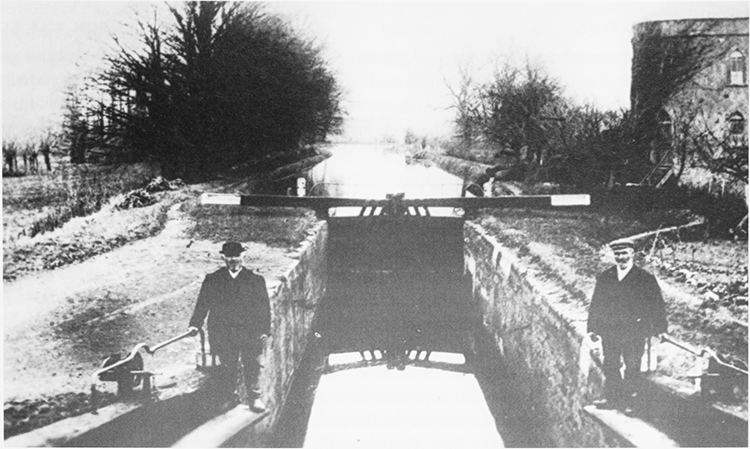
23. The Thames & Severn canal lock and watchman's house near Cerny Wick, before the canal was closed to traffic in 1927.
Milk Products
The Co-operative Wholesale
Society made milk products from the late 1920s, when
evaporated milk production began in converted
buildings at Manor Farm. (fn. 168) In 1935 the Society built a
small factory for the purpose nearby on the south-west
side of Ermin Street. (fn. 169) The factory, called a creamery,
was doubled in size in 1936 and again in 1946;
condensed milk, evaporated milk, and tinned cream
were produced for sale in Co-operative shops
throughout Great Britain and in 1956 c. 139 people were
employed. (fn. 170) The creamery was closed c. 1996 and
demolished c. 2000. (fn. 171) In the 1940s there was also an eggpacking station near Manor Farm. (fn. 172)
Water
A private borehole was sunk near Manor
Farm in 1919, and in 1931, as part of a scheme to supply
Swindon with water, the construction of a second
borehole was started. A pumping station above the
second borehole was built in 1933 and water was piped
to a reservoir on Blunsdon Hill. (fn. 173) New buildings were
later erected on the site, from which water was still
being pumped in 2003.
SOCIAL HISTORY
COMMUNITY ACTIVITIES
Although part of Latton village lay along the main London–Gloucester road, the amercements of an alehouse keeper in the 1580s are the only evidence of a public house in the parish. (fn. 174)
In 1835 there was a lending library open to the 20 men attending an evening Sunday school. (fn. 175) A club room for men given by Henry Eliot, earl of St Germans, was opened in 1910; it was apparently replaced by one given in 1922 by the Co-operative Wholesale Society, from 1918 the owner of nearly all the land in the parish. (fn. 176) The club room given in 1922 was built beside Gosditch of corrugated iron, and was used as a village hall until the late 1960s, when it was demolished. After the village school was closed in 1970, the building was used as a village hall. (fn. 177)
In the 1930s and 1940s a water-filled gravel pit southeast of Gosditch was used as a swimming pool called Latton lido; sheds were built as changing rooms. (fn. 178) After the school was closed its playing field was leased to the parish council and used for public recreation; (fn. 179) it was still a public playing field in 2009.
EDUCATION
The first known day school was built in 1832 to serve the new Latton with Eisey ecclesiastical parish and in 1833 was attended by 50–60 children; there was apparently only one teacher. The school was enlarged in 1850 and was attended by c. 30 children in 1852. In 1853 the master held evening school thrice a week, presumably for older children or adults, (fn. 180) and in 1868 it was said that nearly all the children of the parish were sent to school and that all the young men were literate; the school was popular with mothers who sent their children there and took up employment. (fn. 181) In 1871, when the school could accommodate 72 children, only 41 were present on return day. (fn. 182)
Latton school was rebuilt in 1873 with two classrooms, (fn. 183) and in 1877 it could accommodate 97 pupils. Average attendance in 1877 was 54. (fn. 184) In the early 20th century, when there were two teachers, the number enrolled declined and some children failed to attend when the weather was bad or when they were helping at haymaking or harvest. There were 61 on the roll in 1908, 43 in 1917; (fn. 185) average attendance in 1937–8 was 31. (fn. 186) As the population of the parish increased after the Second World War, so the number of pupils attending the school increased; there were 19 on the roll in 1945, 45 in 1955. From 1958 children over 11 were sent to school at Cricklade, and in the 1960s some children from Latton went to school at Down Ampney. Latton school, which had only 16 pupils in 1969, was closed in 1970. Children from Latton afterwards attended schools at Cricklade. (fn. 187)
CHARITIES FOR THE POOR
By will dated 1725 Harry Burgess gave £50 to benefit the poor of Latton not receiving parochial relief; the interest was to be distributed on All Saints' day, 1 November. In 1730 the capital, with £5 given by John Jordan to benefit the poor of Latton, and supplemented by £6 given by the parish, was used to buy 2 a., with feeding rights, in Purton Stoke; under an inclosure award of 1738 the feeding rights were replaced by an additional 2 a. In 1812 Robert Habgood gave a further £50 for the second poor of Latton, the interest to be distributed on St Thomas' day, 21 December. Burgess's and Jordan's charity, and Habgood's charity, were managed together and in 1834, when the rent of the land was £10, c. 10s. was given to each of 24 recipients. About 1867 the rent was £9 and the income from Habgood's charity was £1 13s. 8d. (fn. 188)
Joseph Norris (d. 1862) gave £50 stock, subject to the life interest of his wife (d. 1866), to increase the sums given by the other two charities. In 1904, when the rent was £8 and Habgood's and Norris's yielded £2 18s. 8d., c. 6s. 6d. was given to each of 32 of the second poor of the parish. (fn. 189) Until 1905 the sums given in any one year were equal to each other; from 1906 they were varied according to the circumstances of the recipients. The three charities continued to be managed together as the Latton charities under a Scheme of 1907. In 1912 £9 os. 10d. was given to 35 adults, and 27 children were each given 1s. The distribution of small sums continued. In the late 20th century and early 21st the trustees of the charity made grants to needy individuals. The income was £224 in 2002, when £190 was spent. (fn. 190)
LOCAL GOVERNMENT
MANOR
Cirencester abbey may already have withdrawn its men of Latton from the jurisdiction of the lord of Cricklade hundred by 1258, the year in which the lord of the hundred sold all his claims against the men, except in respect of return of writs, to the abbey for 40 marks. (fn. 191) In 1259 the abbey's men of Latton were formally exempted from suit at the courts of the hundred, (fn. 192) and in 1289 the abbey claimed the right to have a tumbrel and gallows and to enforce the assize of bread and of ale for Latton. (fn. 193)
In the early 16th century, the abbey apparently held a manor court at Latton twice a year and a view of frankpledge once a year. (fn. 194) In the late 16th century the lord of Latton and Eisey manor held a view of frankpledge and exercised manorial jurisdiction in a single court held jointly for the two places. The court met twice a year in spring and autumn, and at each meeting a jury which incorporated the homage was sworn in. There were two tithingmen of Latton, and offences under the articles of the view were reported by them. They presented offenders in cases of assault and affray, millers for taking excess toll, and a baker and an alehouse keeper for contravening the assizes; the presentments were not numerous. Latton had a hayward and two overseers of its commonable land, and the court heard presentments by the hayward that stray animals had been received and by both the hayward and the overseers that land had been misused and boundaries and streams neglected; the jury, acting as the homage, presented in similar and other cases of agrarian misconduct. The court witnessed admittance to and surrender of copyholds, ordered the rectifying of nuisances and the repair of buildings, gates, and bridges, and made other orders which probably defined, altered, or refined agricultural practices. The jury affirmed, and sometimes added to, the presentments made by the officers and the homage. Caps were not worn on the days required by statute, and the jurors regularly set what was apparently a common fine for the neglect; men were punished for playing bowls unlawfully, and in 1593 it was reported that the statutory requirement to maintain archery butts had not been met. Private pleas were sometimes heard, and in 1592 the court ordered that, when damages would not exceed 40s., no tenant of the manor might prosecute a plea of trespass or debt in any other lower court without the lord's licence. (fn. 195)
In the mid 1630s the court held for Latton and Eisey, called a view of frankpledge with court baron, may still have been biannual; in the 1640s and later it was annual and met in the autumn. In the 17th and 18th centuries two tithingmen, two overseers of commonable land, and a hayward were still appointed, but the court proceeded little on their presentments and mostly on those of the combined jury and homage. Public nuisances were the only offences presented under leet jurisdiction. (fn. 196) In the 1630s and 1680s the court made orders to prevent misuse of common pastures and to repair roads, ditches, and boundaries; in 1635 and 1680 it ordered the tenants to pay the wages of a molecatcher and in 1681 the wages of a pulse keeper; in 1680 it ordered that the stocks and whipping post should be repaired. (fn. 197) From the 1640s to the 1660s the court dealt mainly with the conveyance of copyholds; occasionally the homage was ordered to settle a boundary dispute. (fn. 198) From the mid 1680s and in the early 18th century copyhold conveyance and the nomination of the officers was virtually the only business. (fn. 199)
For the conveyance of copyholds a separate court baron was held when required. It met infrequently in the 16th century, several times a year in the mid 17th, once or twice a year in the early 18th. (fn. 200)
PARISH
Latton parish appointed two overseers each year to relieve its poor. The office may have been informally attached to holdings of land and held in rotation; in the mid 18th century and later it was sometimes held by women. From 1741 to the 1770s or later each overseer served alone for six months. The overseers' accounts are extant for the period 1679–80 to 1781–2. (fn. 201)
The cost of poor relief in Latton was £6 7s. in 1679–80, £12 5s. in 1691–2, and £22 7s. in 1708–9, and it became much higher. It stood at £64 in 1724–5, 1757–8, and 1769–70, (fn. 202) at £84 in 1775–6, and at an average of £136 in the three years ending at Easter 1785. In 1802–3, when £335 was spent, at 11s. the poor rate was far higher than for any other parish in the hundred. Only three adults were relieved permanently, and much was evidently given to the 38 non-parishioners relieved and the 56 parishioners relieved occasionally. Like 117 non-parishioners relieved by St Sampson's parish at Cricklade the 38 were presumably travellers on the London to Gloucester road. (fn. 203) At Latton expenditure reached a peak of £460 in 1812–13, when 41 parishioners were relieved, including 18 permanently, and it was over £300 from 1815–16 to 1818–19. Between 1819 and 1834 it was between £200 and £300, except in 1826–7 when it was £178. (fn. 204)
All poor relief at Latton was outdoor. From the later 17th century to the 1830s paupers were given weekly pay, and for some the parish paid rent; in the later 18th century doles and rent accounted for most spending on the poor. The parish frequently gave clothing and medical assistance and sometimes met funeral expenses; ad hoc gifts included food, cooking utensils, in 1768–9 garden plants and gin, and in 1778 a wooden leg. Occasionally the parish paid for an apprenticeship, (fn. 205) and c. 1775 it held on lease a house which it may have used as a poorhouse. (fn. 206)
The parish had surveyors of highways in the 1630s, (fn. 207) and in the 19th century it usually appointed two. In 1719 it paid for the stocks to be mended, and in 1836 it adopted the watching provisions of the Lighting and Watching Act of 1833 and resolved to spend no more than £30 a year to implement them. (fn. 208)
Latton joined Cricklade and Wootton Bassett poorlaw union at its formation in 1835, (fn. 209) and remained part of it as it became a rural sanitary authority and a rural district. (fn. 210) From 1974 until the district's abolition in 2009 the parish was part of North Wiltshire district. (fn. 211)
RELIGIOUS HISTORY
PARISH CHURCH
Latton church, which was built or rebuilt in the 12th century, was appropriated by Cirencester abbey, to which it was given in 1133. By the mid 13th century a vicarage had been ordained. (fn. 212) In 1819 it was united to the vicarage of Eisey. (fn. 213) In 1952 the vicarage of Latton with Eisey was united to the vicarage of St Sampson's, Cricklade, and the rectory of St Mary's, Cricklade, as the united benefice of Cricklade with Latton; the ecclesiastical parish of Eisey, except for Water Eaton, was united to that of Latton. (fn. 214)
Advowson
The advowson of the vicarage descended with the Rectory estate and with Latton and Eisey manors. From 1313 until the Dissolution all known presentations but one were by the abbot of Cirencester; in 1361 the king presented because the abbacy was vacant. The lords of the manor continued to present after the Dissolution; there were exceptions in 1632, when John Slade presented by grant of a turn, and in 1779, when the bishop collated by lapse. (fn. 215) In 1819 John, earl of St Germans, owned the advowson of both Latton and Eisey, and the advowson of the united benefice was vested in him (fn. 216) and continued to descend with the manor. In 1918 the advowson was retained by John, earl of St Germans (d. withoutmale issue 1922), when he sold his land at Latton. It passed in turn to his cousins Granville Eliot, earl of St Germans (d. 1942), and Montague Eliot, earl of St Germans (d. 1960), who from 1952 was entitled to present at every third vacancy of the benefice of Cricklade with Latton. That entitlement passed in turn to Montague's son Nicholas, earl of St Germans (d. 1988), and Nicholas's son Peregrine, earl of St Germans in 2005. (fn. 217)
Value and Property
The vicarage was of average value. It was worth £4 6s. 8d. in 1291, (fn. 218) £11 14s. 4d. in 1535, (fn. 219) and £237 in 1819 on the eve of the union with Eisey vicarage. (fn. 220) From the mid 13th century or earlier the vicar of Latton was apparently entitled to a third of all the great tithes arising from land held customarily, to a small amount of other great tithes, and to the small tithes. (fn. 221) In 1608 his entitlement was defined as the corn tithes from 12½ yardlands and from 8 a. of the Rectory estate, tithes of wool and lambs except from sheep on the manorial demesne, some tithes of hay, tithes of the mills, other small tithes, and, in place of tithes from the demesne, £4 a year and feeding for several cows. (fn. 222) In 1805, under the inclosure award, 121 a. was allotted to the vicar to replace his entitlement to tithes, and the 121 a. was exchanged for a rent charge related to the price of corn and then worth £161. (fn. 223)
In the mid 13th century the vicar held as glebe two plots of meadow and feeding for 100 sheep, two horses, and 12 oxen. (fn. 224) In 1608 he had a house with a barn and an orchard, 5 a. of arable, and three plots of meadow probably measuring c. 6 a. (fn. 225) At inclosure in 1805 the 5 a. was allotted to the vicar and 1 a. more was allotted to replace the feeding rights which had been held with it. (fn. 226)
The register of burials is complete from 1576. Those of baptisms and marriages are complete from 1578 except for a few years in the 1690s. (fn. 227)
Charities
In the 20th century several sums of
money were given in trust for the upkeep of the
churchyard. By will the Revd W. P. Anderson (d. 1921)
gave £100 stock, in 1927 Margaret Beadon (d. 1943) gave
a similar amount, in 1929 the widow of W. V. Beadon
gave £50 in his memory, and by will Miss F. K. Challis
(d. 1949) gave £50. (fn. 228) The church was not receiving
income from those charities in 2004. (fn. 229)
The Vicarage House
The house standing in 1608
was perhaps that described in 1783 by the vicar as a
hovel, (fn. 230) and in 1787 by the archdeacon as small,
ordinary, and in good repair. (fn. 231) In 1826 it was described
as a low building incapable of repair and with ruinous
thatched outbuildings. Taken down in 1826–7, it was
replaced on a new site in 1827; (fn. 232) the new house was
extended in 1848, (fn. 233) and later the part erected in 1827 was
rebuilt. The house built in 1827 was designed as a threebayed double-pile villa, essentially classical but with
Tudor hoodmoulds and some Gothic windows. It was
intended that stone and roof slates from the previous
house should be used in it; the builder was Thomas
Angell of Highworth. The house was of two storeys,
with two parlours, a kitchen, and service rooms on the
ground floor and five bedrooms on the first. (fn. 234) In 1848 it
was extended northwards to designs by J. P. St Aubyn;
the extension consisted of a two-storeyed double-pile
block containing a kitchen, a servants' hall, and other
rooms on the ground floor and two bedrooms on the
first floor, and of a single-storeyed range containing
service rooms, a coach house, and a stable. (fn. 235) Later in the
19th century the building of 1827 was replaced by a new
block, of four bays and three storeys, with a hipped
roof, and with a ground-floor bay window on the east.
In the late 20th century, when the house was called
Latton House, render was removed, some windows
were replaced, and the staircase was resited. (fn. 236)
Another house called the Corner (now called St Mary's) was built probably on the glebe near the church and possibly on or near the site of the pre-1827 vicarage house soon after 1841. (fn. 237) The Corner was apparently built by H. W. Beadon for his curate and, after his death, it was held on lease by his daughters Mary Beadon (d. 1925) and Margaret Beadon (d. 1943). It was sold with 4 a. of glebe in 1947. (fn. 238) It is the largest house in the village, very plain, and of an L-plan, and it has a double-pile main range of five bays and of two storeys and dormers. In 1910 a cottage in Croft Lane also stood on the glebe. The vicarage house and 9 a. were sold in 1950, and the remaining glebe, the cottage and 1 a., was sold later. (fn. 239)
RELIGIOUS LIFE
If a church stood at Latton in the 11th or early 12th century it might have been served by chaplains of a small minster at Cirencester. (fn. 240) From 1133 until a vicar was instituted it was probably served by chaplains employed by Cirencester abbey, and from the mid 13th century or earlier it was served by vicars presented by the abbey.
In 1553 plate weighing 2 oz. was confiscated for the king, and an 8-oz. chalice was left in the parish. A silver chalice was among the goods in the church c. 1676. About 1890 the parish had a chalice and two patens, all hallmarked for 1861; by c. 1890 old pewter plate had been remade as a ewer for the font. (fn. 241) An additional small silver chalice had been given by 1928, when there were other vessels of silver, glass, or brass. (fn. 242) In 2004 the parish had the chalice and one of the patens hallmarked for 1861 and a chalice, a plate, and a flagon all hallmarked for 1866. (fn. 243)
Two bells hung in the church in 1553. The ring was later increased to five, probably in 1709. In the 1920s and in 2004 five bells hung in the church, four cast by Abraham Rudhall in 1709 and one recast by Thomas Mears of Gloucester in 1841. (fn. 244)
A Puritan, William Edwards, was vicar from 1646 to 1670. (fn. 245) In 1668 he complained that he was prevented from sharing in the choice of churchwardens and that the existing churchwardens were not regular attenders at church and failed to present others for nonattendance or late arrival at services. In that year the churchwardens did present a parishioner for nonattendance and seven other parishioners who had been excommunicated c. 1665, (fn. 246) and in 1671 they presented that the church and all its furniture and ornaments were in very good repair. (fn. 247) A new bible and a new prayer book were bought in 1677, about when the church also had a book of homilies and a copy of Jewell's Apology. (fn. 248) Those excommunicated c. 1665 were Dissenters, and one, William Roberts alias Hayward, who refused to pay church rates in 1674 (fn. 249) may have been a Quaker. Six Dissenters lived in the parish in 1676, (fn. 250) and in 1683 three of those presented in 1668 still refused to attend church. (fn. 251) A woman of Latton charged with witchcraft denied the charge in 1670 and was probably acquitted. (fn. 252)
In the early 18th century the normal practice of one churchwarden being nominated by the incumbent and one by the parish was being followed at Latton. In 1734 the vicar refused to accept as a churchwarden a man nominated by the parish and not a regular churchgoer, (fn. 253) and in 1756 the churchwardens complained that, apparently, too few services were held. (fn. 254) By 1773 no clergyman had lived in the vicarage house for many years. In that year the vicar lived at Down Ampney, where he served the cure. Every Sunday at Latton he held a service and catechized children; additional services were held on holy days, and communion was celebrated at the great festivals with 20–30 communicants. (fn. 255) In 1787 there were two services each Sunday in summer, still only one in winter. (fn. 256) There is no evidence of dissent at Latton in the 18th century.
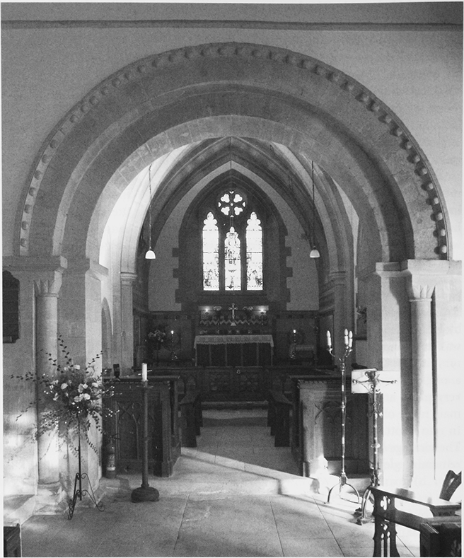
24. Parish church of St John the Baptist, interior looking through the 12th-century chancel arch towards the chancel, which was rebuilt in 1863 by William Butterfield.
John Lyne, vicar from 1780, (fn. 257) was instituted vicar of Eisey in 1817. (fn. 258) Neither benefice had a vicarage house fit for him and he may still have lived at Down Ampney. After he died in 1819, the two benefices were united. (fn. 259) A new vicarage for the united benefice was built at Latton in 1827, (fn. 260) and the vicars apparently resided until 1948. (fn. 261) The vicar from 1838 to 1891 was H. W. Beadon, also vicar of Haselbury Plucknett (Som.), who lived in the vicarage house at Latton, and from 1854 was assisted by a curate at Latton. (fn. 262) There were two services at Latton on Census Sunday in 1851: 78 attended the morning one and 113 the afternoon one. (fn. 263) In the earlier 20th century many services were held besides those held on Sundays. There were still two services each Sunday in the 1960s and 1970s, (fn. 264) one each Sunday in 2004. (fn. 265)
No Nonconformist chapel was built in the parish.
CHURCH BUILDING
The church is known to have been dedicated to St John the Baptist by 1763. (fn. 266) A large three-staged tower and a wide nave of dressed limestone rubble remain from the substantial church begun after church and rectory were given to Cirencester abbey in 1133. The tower and chancel arches are high and wide: the former has billet decoration, the latter pellets, and pellets are repeated on the arch of the south doorway, where both arch and jamb shafts are enriched with chevron. The chancel was apparently rebuilt in the 13th century and in the early 14th century north and south transeptal chapels were added to the nave. Probably in the 15th century the tower was heightened by a fourth stage and some Perpendicular windows were inserted in chancel and nave. The nave was given a new ceiled roof with moulded ribs and bosses, figurative corbels, and perhaps a thatched roof, which was of stone slates by 1810. (fn. 267) A south porch had been built by the mid 17th century. (fn. 268)
The tower was altered again when round-headed belfry windows were inserted in the third stage; the alteration was probably made in 1709, when new bells were hung. Also in the 18th century panelled pews were fitted in the church; the pews were later cut down. In the 19th century alterations to the church were extensive and piecemeal. The chancel was rebuilt twice, between 1810 and 1842 and in the period 1858–63. In 1842 it was described as recent and as modern Gothic. (fn. 269) The second reconstruction was in Decorated Gothic style to designs by William Butterfield and was executed by John Roseblade, a local builder. Butterfield followed Romanesque precedent by distinguishing sanctuary and choir. The sanctuary, which has a ribbed tunnel vault, is raised high and richly finished with encaustic tiles on walls and floor and with stained glass designed by Alexander Gibbs. Unlike the sanctuary, the choir is well lit, and on the north it gives access to an organ chamber and a vestry. Butterfield also designed a replacement porch, remodelled the north transeptal chapel, which had stained glass windows by Gibbs, and designed liturgical furnishings: altar rails, an austere stone font, and a timber pulpit with open panels. (fn. 270) Repairs and alterations to other parts of the church in the 19th century included the alteration of the roof of the nave, the insertion of a large window with intersecting tracery in each of the north and south walls of the nave, the insertion of a new east window in the south transeptal chapel, and the fierce reworking of the decoration around the south doorway. (fn. 271) The roof of the nave was restored to a medieval, probably 15th-century, appearance c. 1992. (fn. 272)
Fragments of Roman columns that are housed in the church are of unknown provenance. (fn. 273)