An Inventory of the Historical Monuments in the County of Northamptonshire, Volume 3, Archaeological Sites in North-West Northamptonshire. Originally published by Her Majesty's Stationery Office, London, 1981.
This free content was digitised by double rekeying. All rights reserved.
'Draughton', in An Inventory of the Historical Monuments in the County of Northamptonshire, Volume 3, Archaeological Sites in North-West Northamptonshire(London, 1981), British History Online https://prod.british-history.ac.uk/rchme/northants/vol3/pp75-77 [accessed 19 April 2025].
'Draughton', in An Inventory of the Historical Monuments in the County of Northamptonshire, Volume 3, Archaeological Sites in North-West Northamptonshire(London, 1981), British History Online, accessed April 19, 2025, https://prod.british-history.ac.uk/rchme/northants/vol3/pp75-77.
"Draughton". An Inventory of the Historical Monuments in the County of Northamptonshire, Volume 3, Archaeological Sites in North-West Northamptonshire. (London, 1981), British History Online. Web. 19 April 2025. https://prod.british-history.ac.uk/rchme/northants/vol3/pp75-77.
In this section
25 DRAUGHTON
(OS 1: 10000 SP 77 NE)
Draughton is a small oval parish of 625 hectares, lying on the W. slopes of a flat-topped ridge and bounded on the W. by a S.-flowing stream. Most of the higher ground, over 150 m. above OD, is covered by Boulder Clay, but to the W. a number of small W.-flowing streams have produced a rolling landscape of spurs and valleys cut into Northampton Sand and Upper Lias Clay. Near the village, beds of the Lower Estuarine Series are exposed.
Of the small number of prehistoric and Roman sites in the parish the best known is the Iron Age settlement (8) which was excavated during the Second World War before it was destroyed by the airfield which occupies much of the eastern half of the parish.
Prehistoric and Roman
Many worked flints have been discovered in the parish including two Mesolithic or later cores, at least four leaf-shaped arrowheads, and one barbed-and-tanged arrowhead (NM; OS Record Cards).
(1) Flint-working site (SP 768780), lies in the N.E. of the parish on Northampton Sand at 160 m. above OD. A large quantity of worked flints, said to be of late Neolithic or early Bronze Age type, have been found here (CBA Group 9, Newsletter, 7 (1977), 27).
(2) Flint-working site (SP 768778), lies 200 m. S. of (1) on Northampton Sand at 152 m. above OD. A quantity of worked flints said to be of late Neolithic or early Bronze Age type has been found here (CBA Group 9, Newsletter, 7 (1977), 27).
(3) Flint-working site (SP 766772), lies N.E. of the village, on Northampton Sand, at 146 m. above OD. A large quantity of worked flints, said to be of late Neolithic or early Bronze Age type, is recorded from the area (CBA Group 9, Newsletter, 7 (1977), 27).
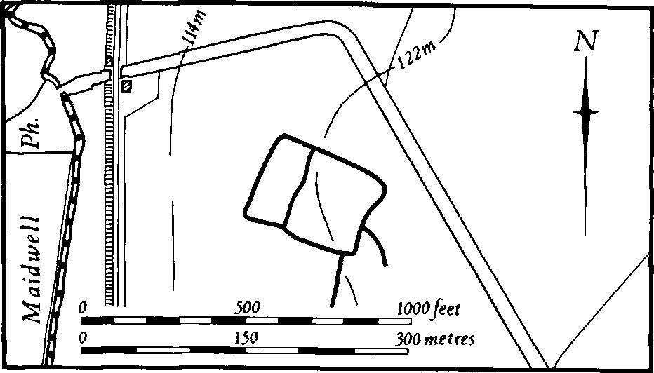
(4) Enclosure (SP 756771; Fig. 61), lies N.W. of the village, on Boulder Clay at 122 m. above OD. Air photographs (in NMR) show the cropmarks of a large rectangular enclosure divided into two parts. Traces of ditches are visible extending S. and S.E. from it.

Fig. 61 Draughton (4) Cropmarks
(5) Ditches (SP 757763), in the S.W. of the parish, on Northampton Sand, at 120 m. above OD. Air photographs (in NMR) show indistinct cropmarks of some short linear ditches set at right angles to each other. These may be parts of overlapping enclosures, though this is uncertain. Further S.E. (at SP 758760) the same photographs show at least three linear ditches running N.W. and W. across the valley side.
(6) Enclosures (SP 766783), lie in the N. of the parish, N.E. of Draughton Lodge, on Northampton Sand and clay at 145 m. above OD. Air photographs (not seen by RCHM) are said to show cropmarks of several irregular adjoining enclosures (BNFAS, 5 (1971), 42).
(7) Barrow (?) (SP 77197628), lies close to the S.E. boundary of the parish on Boulder Clay at 154 m. above OD. It was first recorded in 1962 as a ploughed-down grassy mound, 11 m. in diam. and 0.4 m. high, with no surrounding ditch, and was described as a probable bowl barrow. The site has since been ploughed and the mound further spread. No evidence of the function of the mound has been discovered (OS Record Cards).
(8) Iron Age settlement (SP 77787749), lies on the E. boundary of the parish, on Boulder Clay at 158 m. above OD. The site consisted of a circular area with a diam. of about 30 m. and a ditch. Excavation before destruction by the building of a wartime airfield revealed three hut-sites in the interior. The largest, with a diam. of 10 m., was defined by a continuous roof-water gully 0.9 m. deep from which an overflow gully led to the main external ditch. The two smaller huts, both about 6 m. in diam, were also surrounded by gullies, though these were not complete circles, and had short overflow gullies. Finds included pottery of early Iron Age type and a small amount of fine ware with curvilinear decoration similar to that from Hunsbury. A quantity of high-quality ironstone was thought to indicate that this was the settlement of a small group of iron-workers (S.S. Frere (ed.), Problems of the Iron Age in S. Britain (1955), 21–3; J. Northants. Natur. Hist. Soc. and FC, 31 (1949), 25–31; OS Record Cards).
(9) Roman settlement (centred SP 76057573), extends across the S. boundary of the parish into Lamport, on Northampton Sand at 137 m. above OD. Large quantities of Roman pottery, mostly colour-coated and grey wares of 2nd to 4th-century date, were found in 1969 and near the centre of the area there was a scatter of sandstone. A coin of Hadrian was found in the same area in 1943 (J. Northants. Natur. Hist. Soc. and FC, 31 (1949), 35; BNFAS, 4 (1970), 8; NM).
Medieval and Later
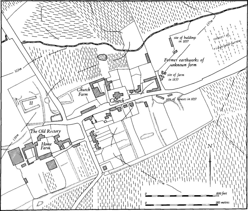
(10) Settlement remains (SP 761767; Fig. 62), formerly part of Draughton, lie around the village, on Northampton Sand between 130 m. and 138 m. above OD. The village stands on a high spur of sandstone orientated roughly S.W.–N.E. and consists of a group of houses and cottages scattered along the main street. At the W. end roads run N. and S. to Maidwell and Lamport. The surviving earthworks, as well as those destroyed, suggest that at some time the village was much more orderly in its layout; it perhaps consisted of a single main street which continued W. of the rectory towards Maidwell, and had a neat arrangement of crofts on the S. extending to a back lane.

Fig. 62 Draughton (10) Settlement remains, (11) Site of manor house
The surviving documents do not indicate any marked reduction in population, but this may be due to the lack of accurate figures before the late 14th century. Draughton is noted in Domesday Book where it is described as three separate manors but no population is recorded for two of them as these belonged to other larger holdings at Rothwell and Maidwell and the three sokemen listed under the third manor are thus of little importance in assessing the size of the village in 1086 (VCH Northants., I (1902), 306, 349, 350). In 1377, 66 people over the age of 14 paid the Poll Tax (PRO, E179/155/28) and in 1674, 49 households paid the Hearth Tax (PRO, E179/254/14). Soon afterwards, in about 1720, Bridges (Hist. of Northants., II (1791), 28) noted that there were about 40 houses here. By 1801, 179 people lived in the parish.
Apart from the manor house site (11), which is described separately, the remains fall into three groups. Behind the existing gardens on the S. side of the main street lie a series of low banks and shallow ditches. These, together with the existing property boundaries, are the remains of former crofts which extended S. to meet a narrow back lane, now a hollow-way, which divided the village from the adjacent ridge-and-furrow. Along the E. side of the Lamport Road modern houses have destroyed other assumed close boundaries. At the E. end of the street a large oval depression cut back into the hillside with a hollow-way to the S.E. is the site of two rows of cottages shown on the Tithe Map of 1837 (NRO). At the W. end of the village, S. of Home Farm, the closes continue; they have been damaged by modern farming but the back lane is still well preserved.
On the N. side of the main street little now remains. To the W. of Church Farm air photographs show part of a small ditched enclosure, now destroyed, and at the extreme E. end of the village there were other earthworks. These are not clear on any available air photographs and have now been entirely destroyed. In 1837 (NRO, Tithe Map) a farm is shown at the W. end of this area and other buildings to the N. (RAF VAP CPE/UK/1994, 2450–2; CUAP, BAP83, 84).
(11) Manor house site (SP 759768; Fig. 62), lies N. of the Old Rectory at the W. end of Draughton village, on Northampton Sand at 127 m. above OD. The remains consist of a wide ditch only barely visible, on three sides of a sub-rectangular area, and were perhaps part of a formal garden. This narrow garden lies at the N. end of an open area which is bounded on the E. and S. by a low bank. Beyond the E. bank is a broad, shallow hollow-way, probably the predecessor of the present road to Maidwell. In 1837 the name given to this field was Nineveh (NRO, Tithe Map; RAF VAP CPE/UK/1994, 2451–3; CUAP, BAP83).
(12) Dam (SP 760762), lies S. of the village, within a steep-sided narrow valley draining S.W., on Upper Lias Clay at 115 m. above OD. The site may be that of a medieval mill or fishpond.
The remains consist of a dam, breached in the centre to allow the present stream through and thus consisting of two banks projecting into the valley bottom. These banks are 10 m. long overall and 1.5 m.–1.75 m. high, with flat tops 2 m. across. The N. bank is separated from the valley side above it by a narrow channel which extends S.W. to form a very large ditch up to 12 m. wide and 2.5 m. deep and embanked on its S. side. After a short distance the channel turns S. and fades out when it reaches the stream. Its purpose is not clear but it may have once been an over-flow channel from the pond behind the dam, though its level in relation to the dam is peculiar.
(13) Pond (SP 757768), lies N.W. of Draughton village, in the valley of a small W.-flowing brook, on Upper Lias Clay at 114 m. above OD. Before damage by modern ploughing it consisted of a rectangular depression 40 m. by 25 m. with an outlet channel on the N.W. leading into the stream. It was fed by a smaller stream which flowed down the hillside from a spring to the S.E. Both the pond and the springhead have now been reduced to marshy depressions as a result of modern agricultural activities (RAF VAP CPE/UK/1994, 2451–2).
(14) Cultivation remains. The date of the enclosure of the common fields of the parish is not known. Ridge-and-furrow of these fields survives on the ground or can be traced from air photographs over about half the parish and, in particular, around and to the N. of the village. In the S., and in the E. on the disused airfield, most of it has been destroyed. The landscape of the parish, consisting of a series of E.–W. spurs, has determined a pattern of furlongs orientated predominantly N.–S., but with many interlocked blocks of ridge-and-furrow in response to changes in direction of slope (RAF VAP CPE/UK/1994, 2449–52, 4453–6; 106G/UK/636, 4191–5, 3191–5).
Undated
(15) Enclosure (SP 76247808), W. of Draughton Lodge on clay at 130 m. above OD. Air photographs (CUAP, BAP84) show soilmarks of a rectangular enclosure, 12 m. by 25 m., apparently overlying ridge-and-furrow.