An Inventory of the Historical Monuments in the County of Northamptonshire, Volume 3, Archaeological Sites in North-West Northamptonshire. Originally published by Her Majesty's Stationery Office, London, 1981.
This free content was digitised by double rekeying. All rights reserved.
'Dodford', in An Inventory of the Historical Monuments in the County of Northamptonshire, Volume 3, Archaeological Sites in North-West Northamptonshire(London, 1981), British History Online https://prod.british-history.ac.uk/rchme/northants/vol3/pp72-75 [accessed 19 April 2025].
'Dodford', in An Inventory of the Historical Monuments in the County of Northamptonshire, Volume 3, Archaeological Sites in North-West Northamptonshire(London, 1981), British History Online, accessed April 19, 2025, https://prod.british-history.ac.uk/rchme/northants/vol3/pp72-75.
"Dodford". An Inventory of the Historical Monuments in the County of Northamptonshire, Volume 3, Archaeological Sites in North-West Northamptonshire. (London, 1981), British History Online. Web. 19 April 2025. https://prod.british-history.ac.uk/rchme/northants/vol3/pp72-75.
In this section
24 DODFORD
(OS 1: 10000 a SP 56 SE, b SP 66 SW, c SP 65 NW)
The parish, of some 560 hectares, lies W. of Watling Street which forms much of the E. boundary, though a small area extends across the Roman road as far as an S.-flowing stream. Most of the parish lies astride the valley of an E.-flowing brook which, together with a number of small tributaries, has cut deeply into the underlying Middle Lias clays and silts between 120 m. and 80 m. above OD. To the N. and S. of the stream the land rises to more than 130 m. above OD and there are extensive spreads of glacial clays, sands and gravels. A small S. projection of the parish extends across a ridge into the valley of the R. Nene.
The major monument of the parish was the settlement remains (1). These have been almost entirely destroyed, and thus the main contribution to the understanding of the complex history of the village's structure has been lost.
Prehistoric and Roman
Several Roman coins, some of Constantine and one of Tetricus, have been found in the parish, mostly along Watling Street which forms part of the E. boundary (Morton, Nat. Hist. of Northants. (1712), 532; J. Bridges, Hist. of Northants., I (1791), 50).
For Roman Road 1f, Watling Street, see Appendix.
Medieval and Later
A 14th-century coin, identified as a Burgundian imitation of an English quarter-noble of the type struck in Flanders for Philip the Bold was found in 1955 in the N. of the village (SP 61356085; BM; Brit. Num. J., 28 (1955), 201).
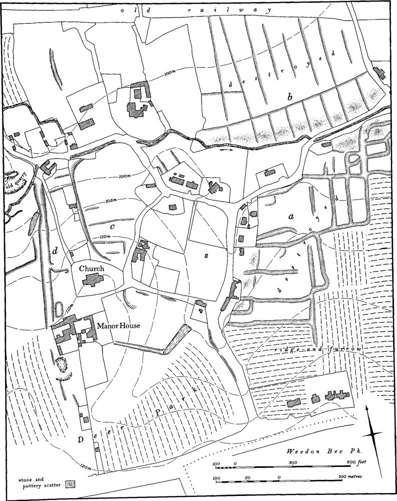
b(1) Settlement remains (centred SP 615606; Figs. 12, 59 and 60), formerly part of Dodford, lay in and around the existing village on the sides of a small E.-flowing stream and its tributaries, on glacial sands and gravels and Jurassic Clay between 90 m. and 120 m. above OD. Most of the earthworks have been ploughed out in recent years and the accompanying plan has been compiled, in great part, from air photographs taken before destruction.
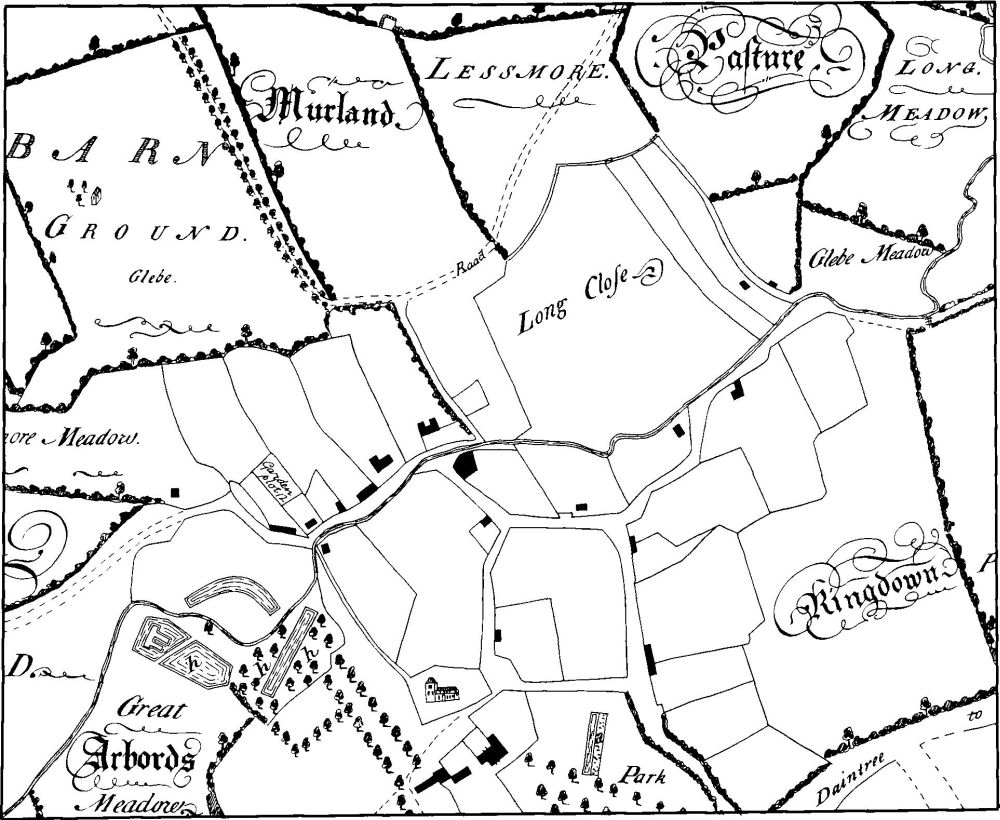
The remains suggest either a large-scale depopulation at some time or, more likely, a considerable movement of the village over the centuries. However the surviving documents do not give any clue as to which of these alternatives is correct. Dodford is first mentioned in an Anglo-Saxon charter of 944 (BCS 792). It is recorded in Domesday Book as a manor of three hides belonging to the Count of Mortain, with a recorded population of 22 including a priest (VCH Northants., I (1902), 326). Thereafter no certain indication of its size is ascertainable until 1673 when 39 people paid the Hearth Tax (PRO, E179/254/41). By the early 18th century there were 21 houses in the village (J. Bridges, Hist. of Northants., I (1791), 50). In 1801 two hundred and five people lived in the parish. A map of 1742 (NRO; Fig. 60) shows the village exactly as it is today with the settlement remains already abandoned.
The surviving earthworks, together with those which have been destroyed, fall into four distinct groups. To the S. of the stream and E. of the main through street ('a' on plan) was a series of long rectangular paddocks bounded by shallow ditches. These have all been destroyed but stone-rubble and pottery, mainly of the 13th and 14th centuries, has been found at the W. and N. ends of some of them indicating that they were once tofts and crofts of the village. In 1742 many of these were still hedged closes.
To the N. of the stream ('b' on plan) and now also destroyed were some unusual rectangular tofts and crofts extending up the hillside. These too have scatters of stone and medieval pottery at their S. ends and must be the remains of former houses and gardens. The extremely regular plan of the earthworks implies an element of planning here.

Fig. 59 Dodford (1) Settlement remains, (2) Deer park
Immediately N. of the church are other slight earthworks which may be former closes ('c' on plan) though little remains on the ground. Only to the W. of the church and the N. of the manor house do earthworks survive ('d' on plan). Here a shallow hollow-way, which perhaps once extended S. to the present main Northampton-Daventry road, runs N. down the valley side to meet the E.–W. village street. Slight banks on either side may be former closes (RAF VAP CPE/UK/1994, 1269–70).
b(2) Deer park (centred SP 613603; Figs. 59 and 60), lies immediately S. of the village, between it and the A45 road on glacial sands and gravels, between 100 m. and 120 m. above OD. Its exact extent is not known.
Bridges (Hist. of Northants., I (1791), 50) records that 'there was formerly a park including 30 acres of wood ... but the ground hath long since been applied to other uses'. It was apparently enclosed by William de Keynes who acquired the manor of Dodford in 1222. By the 14th century it was said to be 50 acres in extent (Cal. IPM xii, 49–50). The location of the park is partly shown on the map of Dodford of 1742 (NRO); the latter gives the name Park to the large pasture field S. of the manor house. However as this field is relatively small the park must have extended further W. than the present field. The S. side of the park is formed by a precipitous slope with a small bank below it immediately N. of the main A45 road. Along the E. side of the park a low bank or scarp runs along the W. side of the road to Dodford village. No other convincing boundaries survive, though a very low bank extends W., N. of and roughly parallel to the A45 (SP 61056026) for some 200 m. The park may have occupied the land N. of this bank as far as the marshy area N.W. of the village. In the bottom of the valley, near the N.E. corner of the park (SP 61376032), is a rectangular pond embanked on its S.E. and N.E. sides (Northants. P. and P., 5 (1975), 221).

Fig. 60 Dodford (1, 2) Village and deer park in 1742 (from a map in NRO)
(3) Cultivation remains. The common fields of Dodford were enclosed by private agreement in 1623 (NRO, Grant (Li) H5), though the earliest map of the parish is of 1742 (NRO). Ridge-and-furrow of these fields survives on the ground or can be traced on air photographs immediately N., E. and S. of the village. The furlongs to the S. are mainly orientated N.–S. as the land falls S. to the R. Nene but elsewhere they interlock, in response to the more broken terrain (RAF VAP CPE/UK/1994, 1166–8, 1268–71).