An Inventory of the Historical Monuments in the County of Northamptonshire, Volume 2, Archaeological Sites in Central Northamptonshire. Originally published by Her Majesty's Stationery Office, London, 1979.
This free content was digitised by double rekeying. All rights reserved.
'Warkton', in An Inventory of the Historical Monuments in the County of Northamptonshire, Volume 2, Archaeological Sites in Central Northamptonshire(London, 1979), British History Online https://prod.british-history.ac.uk/rchme/northants/vol2/pp150-152 [accessed 11 April 2025].
'Warkton', in An Inventory of the Historical Monuments in the County of Northamptonshire, Volume 2, Archaeological Sites in Central Northamptonshire(London, 1979), British History Online, accessed April 11, 2025, https://prod.british-history.ac.uk/rchme/northants/vol2/pp150-152.
"Warkton". An Inventory of the Historical Monuments in the County of Northamptonshire, Volume 2, Archaeological Sites in Central Northamptonshire. (London, 1979), British History Online. Web. 11 April 2025. https://prod.british-history.ac.uk/rchme/northants/vol2/pp150-152.
In this section
59 WARKTON
(OS 1:10000 a SP 88 SE, b SP 98 SW, c SP 87 NE, d SP 97 NW)
The parish is of irregular shape and covers just over 754. hectares, immediately N.E. of Kettering, on the S.E. side of the R. Ise which forms part of its W. boundary. The higher N.E. part is largely level Boulder Clay land around 107 m. above OD. To the S. the land falls S. and S.W. to 76 m. above OD. Here the down-cutting of the R. Ise, and of the Cranford Brook to the E., has exposed large areas of limestones, sands, silts and clays.
Prehistoric and Roman
A single Roman coin (unlocated) is recorded from the parish (J. Bridges, Hist. of Northants., 2 (1791), 265).
b(1) Enclosure (SP 90728050), in the E. of the parish, on Boulder Clay at 107 m. above OD. Air photographs (in NMR) show a small D-shaped enclosure covering just under 1 hectare, with a ditch extending N.E. from the N. corner (BNFAS, 6 (1971), 18).
Medieval and Later
c(2) Settlement Remains (SP 893798; Fig. 134), formerly part of Warkton, lie in and around the present village on land sloping W. to the R. Ise. The surviving earthworks are, in the main, the sites of former houses and associated buildings, situated between and alongside the standing structures. Their survival is of some interest, however, as it is a direct result of the lack of modern development. The remains suggest that the village has not altered in basic layout since at least the early 18th century (NRO, various maps of Warkton). An interesting feature is that the earthworks indicate that the present village green was formerly much larger having been radically reduced in size by encroachments (RAF VAP F22 540/RAF/1312, 0130–1).
(3) Cultivation Remains. The common fields of the parish were enclosed in 1810, following the Act of Parliament of 1807 (VCH Northants., IV (1937), 265; NRO, Enclosure Map, 1808).
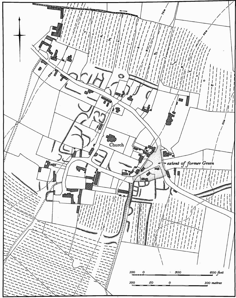
Fig. 134 Warkton (2) Settlement remains
In a series of early 18th-century maps (at Boughton House, copies in NRO) the layout of the fields at that time is depicted. There were then three fields, Mead Field S. of the village and now entirely within Kettering parish, Moor Field E. of the village, and Wood Field to the N.E. Ridge-and-furrow of these fields exists on the ground or can be traced from air photographs in a number of places. Only a few fragmentary remains are visible in the former Mead Field, but in the area of Wood and Moor Fields there are large areas of end-on furlongs mainly orientated across the contours with massive headlands 15 m. wide and up to 250 m. long. The extreme N.E. of the parish was an area of open common and woodland in the early 19th century, but near the S. end was an isolated block of strips completely surrounded by common. This furlong, then known as Near Newlands, probably represents the last point reached by the medieval agricultural expansion. The ridge-and-furrow associated with these strips is still visible on air photographs near Acreland Farm (SP 913811). Ridge-and-furrow also exists N. of the village in an area which in the early 18th century was outside the common fields. Most of this area was already old enclosures at that time but one part, then known as North Mead, was divided into strips (SP 895802; RAF VAP 541/474, 3053–6; 541/602, 3117–20, 4095–8; 4116–23; F22 82/RAF/ 865, 0332–5; F21 540/RAF/1312, 0127–31; F22 540/RAF/1312, 0127–31).