An Inventory of the Historical Monuments in the County of Northamptonshire, Volume 2, Archaeological Sites in Central Northamptonshire. Originally published by Her Majesty's Stationery Office, London, 1979.
This free content was digitised by double rekeying. All rights reserved.
'Walgrave', in An Inventory of the Historical Monuments in the County of Northamptonshire, Volume 2, Archaeological Sites in Central Northamptonshire(London, 1979), British History Online https://prod.british-history.ac.uk/rchme/northants/vol2/pp146-150 [accessed 28 April 2025].
'Walgrave', in An Inventory of the Historical Monuments in the County of Northamptonshire, Volume 2, Archaeological Sites in Central Northamptonshire(London, 1979), British History Online, accessed April 28, 2025, https://prod.british-history.ac.uk/rchme/northants/vol2/pp146-150.
"Walgrave". An Inventory of the Historical Monuments in the County of Northamptonshire, Volume 2, Archaeological Sites in Central Northamptonshire. (London, 1979), British History Online. Web. 28 April 2025. https://prod.british-history.ac.uk/rchme/northants/vol2/pp146-150.
In this section
58 WALGRAVE
(OS 1:10000 a SP 77 SE, b SP 87 SW)
The long, narrow parish, 935 hectares in area, lies midway between Kettering and Northampton, on land sloping generally S.W. between 137 m. and 84 m. above OD. The higher, N.E. part is largely covered by Boulder Clay, but the down-cutting of a number of small S.W.-flowing streams has exposed large areas of Upper Lias Clay separated by narrow interfluves of Northampton Sand. Walgrave is notable for the well-preserved group of medieval and earlier earthworks including the important settlement remains (7) which apparently show a short-lived extension to the village, and for the medieval fishponds and 17th-century garden remains (8).
Prehistoric and Roman
a(1) Ditched Trackway (SP 793711), in the S.W. of the parish, on clay at 99 m. above OD. The trackway, running E.—W., is said to be visible on air photographs (not seen by RCHM; BNFAS, 7 (1972), 56).
b(2) Ring Ditch, Enclosure and Ditches (SP 804713; Fig. 68), lie in the S. of the parish 750 m. S.S.E. of the church, on Northampton Sand at 120 m. above OD. Air photographs show a ring ditch 30 m. in diam., with a large ovoid enclosure attached to its N.E. side from which a number of ditches extend N. and N.W. (CUAP, YX 96, 97).

Fig. 130 Walgrave (6) Moat
b(3) Roman Settlement (?) (SP 80307209), in the centre of the village, on sand at 100 m. above OD. During the digging of foundation trenches in 1970 large quantities of Roman pottery, apparently of the late 3rd to early 4th centuries, were discovered. Medieval and later pottery is also recorded (BNFAS, 5 (1971), 25).
b(4) Roman Settlement (?) (SP 896723), N.E. of the village, on Boulder Clay at 110 m. above OD. Quantities of Roman pottery are said to have been discovered in the area during modern building development but no details are known (local inf.).
Medieval and Later
Medieval pottery has been found in the S.W. of the parish (at SP 790708).

Fig. 131 Walgrave (7) Settlement remains
b(5) Mound (SP 82477339), in the E. of the parish, on Boulder Clay at 73 m. above OD, close to the main Northampton—Kettering Road. On air photographs taken in 1947 (RAF VAP CPE/UK/1915, 3230–1) before ploughing it appears to be trapezoidal with sides 22 m. long but it now survives only as a mound 30 m. in diam. and 1 m. high. It is possibly a damaged barrow, but the former Gibb Wood close by may indicate that the mound was for a gibbet and is not prehistoric. However, if the trapezoidal form is original the feature may be a 17th-century gun battery.
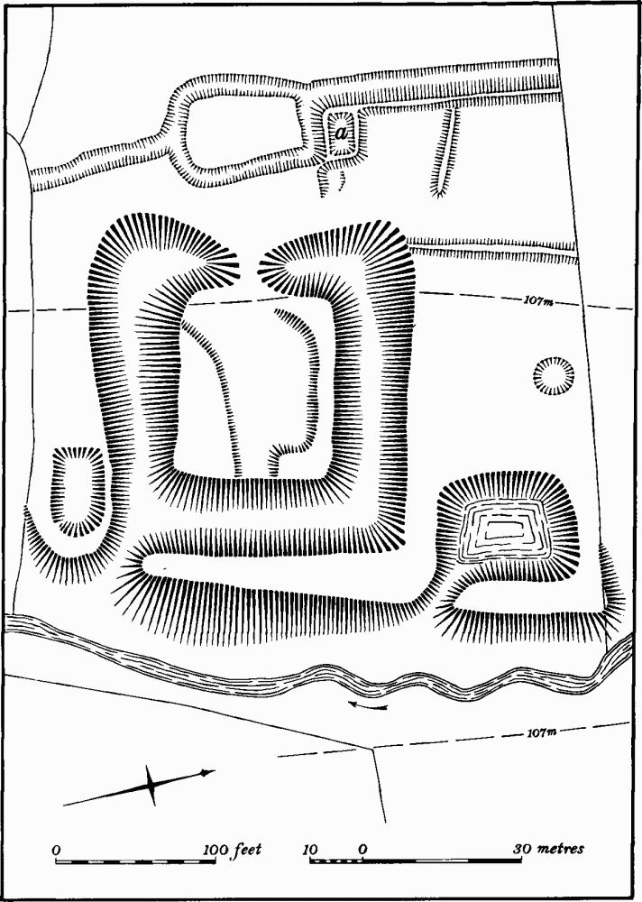
b(6) Moat (SP 80207234; Fig. 130; Plate 8), lies immediately N. of the village, on clay at 107 m. above OD, on the W. side of a small S.-flowing stream. The stream has cut a deep channel, and the moat, which stands well above it, was formerly filled by seepage from the adjacent hill-side to the W. Nothing is known of its history except that it was perhaps called 'Northall' (VCH Northants., IV (1937), 217). Certainly by the 18th century the field in which it lies was known as North Hall Close (NRO, Maps of 1778 and 1792).

Fig. 132 Walgrave (8) Garden remains and fishponds
A small rectangular island is completely surrounded by a deep ditch, up to 3 m. deep in the N.W. corner. There is a causewayed entrance in the centre of the W. side. The interior has a slightly sunken centre and a rectangular platform in the N.E. corner. The water was retained in the ditch by a massive external bank or dam on the lower, E. side above the stream. This still stands up to 3 m. high. Immediately outside the S.E. corner there is a small embanked depression, perhaps formerly a pond, and N.E. of the moat is another pond, originally rectangular but recently partly filled with top-soil. Immediately W. and N.W. of the moat there was formerly a group of other earthworks, now entirely destroyed (shown on Fig. 130, but plotted from air photographs). They consisted of a length of bank with a ditch on its W. side, which at its S. end, turned E. and enclosed a small sunken rectangular platform, probably a former house-site ('a' on Fig. 130). To the S. was a circular arrangement of ditches, perhaps of recent date, and other banks lay to the N. and N.E. (CUAP, AIL 55, BAP 98). Small-scale excavation in the area W. of the moat was undertaken in advance of destruction in 1971, but no indication of occupation was discovered (DOE Arch. Excavations 1971, (1972), 33).
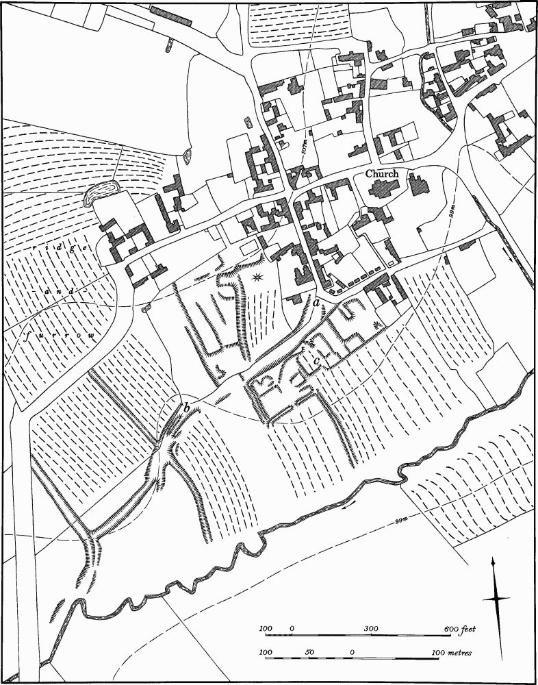
b(7) Settlement Remains (SP 801717; Fig. 131), formerly part of Walgrave, lie immediately S. of the village, on the side of a small S.W.-flowing stream, on clay at 99 m. above OD.
The available statistics relating to the size of Walgrave are unhelpful beyond suggesting a decline in population between 1086 and 1377. The recorded population given in Domesday Book is 51 (VCH Northants., I (1902), 306, 328, 353). In 1332–4 the vill paid 62s. 8d. in tax, and 67s. 5d. in 1348–9 (PRO, El79/155/3). In 1377 151 people over the age of 14 paid Poll Tax (PRO, E179/155/28) and 46 people the Hearth Tax in 1674 (PRO, E179/254/14). In 1801 the total population of the parish was 424.
The remains, though slight, are remarkable for two reasons. First, because part of the main hollow-way ('a'— 'b' on Fig. 131) continues the line of the present lane on the S. side of the village, as well as being parallel with the existing main street to the N. it appears to form part of the rectangular layout of the modern village. Secondly, the house-sites on the S. side of the main hollow-way seem to have been constructed over existing ridge-and-furrow. Certainly in one place ('c' on Fig. 131) at least three of the adjacent ridges to the S. continue northwards and still survive within the village closes.
The remains consist of a broad hollow-way ('a'—'b' on Fig. 131), up to 1.5 m. deep at the E. end, but only 0.5 m. deep to the W. On its S. side are a series of rectangular paddocks or closes bounded by low banks and scarps nowhere more than 0.25 m. high. Within some of these there are traces of former buildings. To the N. of the hollow-way are more indeterminate earthworks which include a long ditch or hollow-way, ridge-and-furrow, and a number of low scarps. The main hollow-way extends W. of the village remains and can be traced for some 200 m. until it meets another hollowway at right-angles (RAF VAP CPE/UK/1925, 3365–6). The remains had already been abandoned by the late 18th century when the area S. of the hollow-way was known as Atterbury's Close. The hollow-way itself was apparently still in use and called Gurst Lane (NRO, maps of 1778 and 1792).
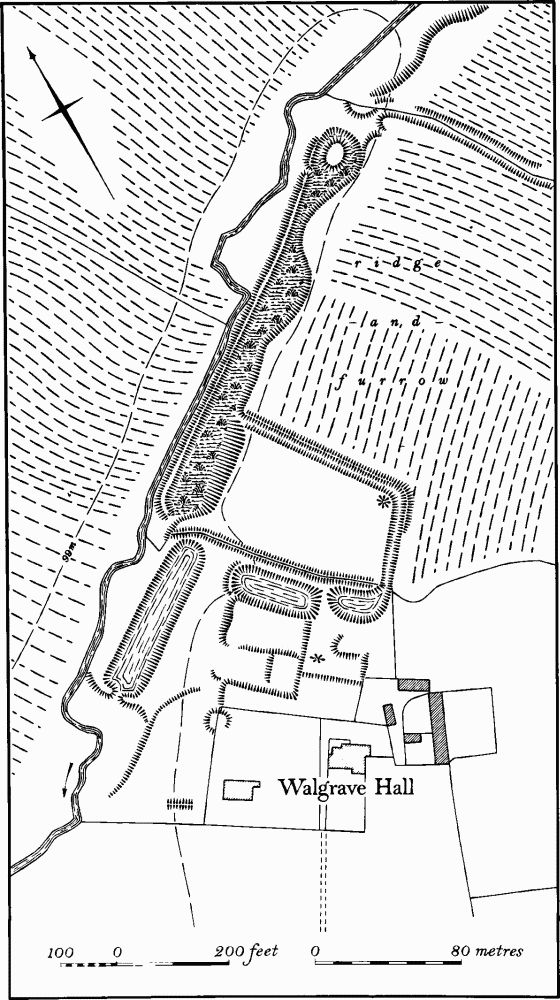
b(8) Garden Remains and Fishponds (SP 807721–806719; Fig. 132), lie N. of Walgrave Hall within and on the S. side of a small valley cut in Upper Lias Clay, between 95 m. and 105 m. above OD. The hall, which contains parts of a 17th-century building, stands on, or close to, the site of the main medieval manor house of the village. The fishponds are probably to be associated with this medieval house, while other earthworks are the remains of gardens laid out in 1671– 4, when the present house was built by the Langham family (VCH Northants., IV (1937), 217–20).
The Fishponds lie in the bottom of the valley, which here has a marked asymmetrical cross-profile resulting from uniclinal shifting of the S.W.-flowing stream. The ponds were constructed in the bed of the original stream, traces of which still survive in the upper, N.E. pond. The natural valley slope forms the steep S.E. sides of these ponds and the stream was moved N.W. to pass outside the ponds, forming an overflow channel. The upper pond is extremely long and narrow with an irregular S.E. side and a retaining bank 1.5 m. high on the N.W. side. At its extreme N.E. end there is a small circular mound, formerly an island, perhaps used as a refuge for water fowl (see Sectional Preface, p.lix). The lower pond is smaller and more rectangular with a wide retaining bank on the N.W. side. On maps of 1778 and 1792 (NRO) only the lower pond is depicted, though in a schedule to the 1792 map the area containing the upper pond is described as having been a former pond. To the S.E. of these fishponds, in a small tributary valley at right-angles to the main one, are two other ponds, up to 4 m. deep. These too may have originated as medieval fishponds, but appear to have been altered to form part of the Garden remains to the S.W. The latter consist of a rectangular area cut into the gentle slope, and bounded by low scarps 0.5 m. high. These may be the footings of walls enclosing the garden, for there is evidence of stone rubble within them. More stone rubble, as well as 17th-century brick foundations, is exposed along the edge of the adjacent pond. S.E. of this terrace or garden are more irregular low scarps and banks, perhaps the site of a former building, and other banks lie to the S.W. To the N.E. of the ponds, in the angle between them and the medieval fishponds, is a rectangular area bounded on the N.E. and S.E. by a low bank and ditch. This is respected by the adjacent ridge-and-furrow and may be either medieval or later in origin. On both the 18th-century maps the two ponds in this garden are shown.
a(9) Windmill Mound (SP 79657198), lies W. of the village, 200 m. W. of Mill Farm, on the crest of a hill, on sand at 110 m. above OD. It is now ploughed and only survives as a slight mound 1 m. high and 20 m. in diam. However on air photographs taken before destruction it appears to have been much higher, with a well-marked hollow in the centre, and surrounded by a ditch 3 m. wide. The adjacent ridge-and-furrow respected it. The site may be that of the windmill referred to in the 16th century as belonging to the manor of Walgrave (VCH Northants., IV (1937), 218, n. 23), and certainly on a map of 1778 (NRO) a post mill is shown on the site. No mill is marked there on the 1792 map (NRO) but the field is called Windmill Close. A windmill is depicted on the 1st ed. 1 in. OS Map (1834) (RAF VAP CPE/UK/1925, 2226–7).

Fig. 133 Walgrave (12) Cultivation remains
a(10) Site of Watermill (SP 79337205), W. of the village in the bottom of a valley draining to the S., on Upper Lias Clay at 99 m. above OD. The remains have been much damaged by later activity but traces of a long triangular pond lying S.E. of and parallel to the existing stream, as well as remains of brick and stone rubble to the S.W. of it, still exist. This may be the watermill referred to in the 16th century as belonging to the Manor of Walgrave (VCH Northants., IV (1937), 218, n. 23). On a map of 1778 (NRO) the pond is shown as water-filled, with a building, presumably the mill, to the S.W. On a slightly later map of 1792 this is shown without alterations. The site was called Walgrave Mill as late as 1834 and the mill may still have been in use (1st ed. 1 in. OS Map; RAF VAP CPE/UK/1925, 2226–7).
b(11) Enclosure and Hollow-Ways (SP 813726; Plate 27), lie E.N.E. of the village on the S. side of the Kettering Road, on sands and clays at 107 m. above OD. At the point where two small S.W.-flowing streams meet in a small shallow valley there is a large area of permanently damp ground above which the adjacent ridge-and-furrow terminates. Just S.W. of the stream junction several hollow-ways cross the valley and, on the N.W. side, cut the ridge-and-furrow. N. of the hollow-ways, and lying across the southernmost stream, is a roughly rectangular enclosure, bounded by a low bank, with an entrance in its lower S.W. side. It overlies ridge-and-furrow on the N., but the hollow-ways went round it on the S. (CUAP, BAP 96).
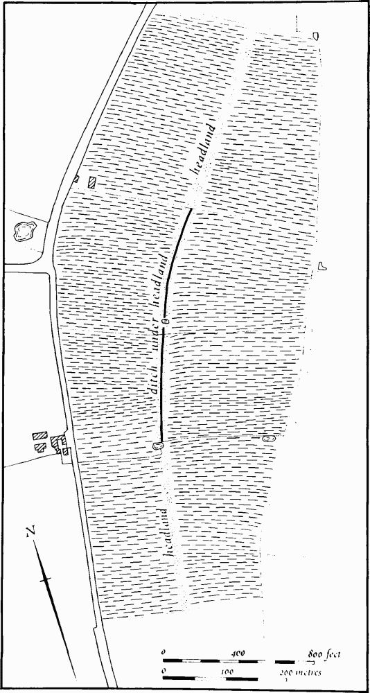
(12) Cultivation Remains (Figs. 109 and 133; Plate 27). The common fields of the parish were enclosed by Act of Parliament of 1776 (NRO, Map of 1778). However Bridges states that there were, in the 17th century, 100 acres of old enclosures in the parish as well as 9 yardlands of new enclosures (J. Bridges, Hist. of Northants., II (1791), 127). This suggests that enclosure took place piecemeal over a long period.
Ridge-and-furrow of these fields exists on the ground or can be traced on air photographs over most of the parish. Almost the entire pattern is recoverable. Most of it is arranged in end-on furlongs, usually of reversed-S form, lying at right-angles to the contours along the valley sides. Where ridge-and-furrow survives two features constantly recur. One is the over-ploughing of headlands between end-on furlongs to form abnormally long furlongs. This produces a marked rise in the ridges, often accompanied by a sharp change of direction or a double reversed-S curve. The other feature is the apparent shortening of furlongs so that rather battered and worn-down ridges of an earlier period extend beyond the normal terminations of the ridges. Both these features are shown on Plate 27 (around SP 813726). Elsewhere headlands still survive as broad ridges up to 800 m. long and 20 m. wide (e.g. SP 811722 and 800741).
Some of the end-on furlongs in the parish which are now partially destroyed by modern ploughing show what appear to be earlier ditch systems under the later headlands. For example near Walgrave Lodge (SP 803738; Fig. 133) the central section of a headland, now ploughed away, has a ditch under it and on the same alignment. This may be part of an earlier field system (see Section Preface, p. lxii).
Ridge-and-furrow also exists in what appear to have been old enclosures prior to the general enclosure of the parish (e.g. around SP 811747). The ridge-and-furrow here is indistinguishable from that elsewhere in the parish. Ridge-and-furrow immediately S. of the village has been partly destroyed by former house-sites (7) (RAF VAP CPE/UK/1925, 2224–32, 2361–8, 3225–31, 4362–4; CPE/UK/1926, 3363–71; F21 540/RAF/1312, 0214–20; F22 540/RAF/1312, 0157–9, 0214–8).