Ancient and Historical Monuments in the County of Gloucester Iron Age and Romano-British Monuments in the Gloucestershire Cotswolds. Originally published by Her Majesty's Stationery Office, London, 1976.
This free content was digitised by double rekeying. All rights reserved.
'Lechlade', in Ancient and Historical Monuments in the County of Gloucester Iron Age and Romano-British Monuments in the Gloucestershire Cotswolds(London, 1976), British History Online https://prod.british-history.ac.uk/rchme/ancient-glos/pp73-77 [accessed 11 February 2025].
'Lechlade', in Ancient and Historical Monuments in the County of Gloucester Iron Age and Romano-British Monuments in the Gloucestershire Cotswolds(London, 1976), British History Online, accessed February 11, 2025, https://prod.british-history.ac.uk/rchme/ancient-glos/pp73-77.
"Lechlade". Ancient and Historical Monuments in the County of Gloucester Iron Age and Romano-British Monuments in the Gloucestershire Cotswolds. (London, 1976), British History Online. Web. 11 February 2025. https://prod.british-history.ac.uk/rchme/ancient-glos/pp73-77.
LECHLADE
(12 miles E. of Cirencester)
A Roman building discovered 'in a meadow near Lechlade' before 1742 is not precisely located; it is reported that it measured about 50 ft. by 40 ft. and had a tessellated floor supported on brick pillars. (fn. 1) Early O.S. records site it at SP 21660061 (see (4), below), but the 'subterranean building' marked on the O.S. 6-inch edition of 1873–85 (Glos. LII, S.W.) is noted as having been found about the end of the 18th century; hence the early account may refer to the building at Great Lemhill Farm (7), or perhaps to another building now lost.
All but one of the monuments in the parish lie on gravel terraces of the rivers Thames, Coln and Leach, around 250 ft. above O.D.; the exception (9) is situated on limestone at 300 ft. above O.D.
Crop-marks in Fairford (6) are continuous with others in Lechlade (8).
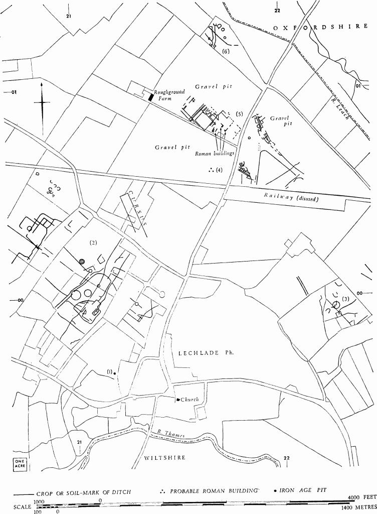
(1) Iron Age Pit (SU 212996), in 'The Loders', 400 yds. W.N.W. of the church, yielded pottery, including haematite ware, and sherds bearing incised decoration with white inlay. Plan, p. 74.
MPBW Excavations, 1965, 4. Oral information from Mrs. M. U. Jones.
(2) Enclosures and Tracks (SP 211002), undated, are revealed by crop-marks extending over some 50 acres N.W. of the parish church (Plate 60). The S.E. ditch of the track intersecting a ring-ditch at SP 209000 was almost certainly cut into a mound within the ring ditch (cf. Kempsford (7) and p. lv).
OAP Allen, 721–2. C.U.A.P., OAP AM 29–30, CD 46–9, DX 32–4, PV 38–9, VM 6–12, AFV 23, AYG 52, 54–7, 59, 61, AYI 20.
Oxon, VII (1942), 113, No. 7; VIII-IX (1943–4), 96, No. 6a.
(3) Enclosures, Linear Ditches and Track (SU 223999), undated, show as crop-marks covering about 5 acres, 900 yds. N.E. of the church.
N.M.R., OAP SU 2299/3/383–4. C.U.A.P., OAP ZH 90. O.S., VAP 70 167, 080–1.
Oxon, VII (1942), 113, No. 9.
(4) Probable Roman Building (SP 21660061), 2/3 mile N. of the church, has been obliterated, but the site is marked on O.S. maps (see introductory paragraph).
(5) Iron Age and Romano-British Settlement (SP 217008), by Roughground Farm, partly excavated before destruction by gravel-digging, extended over more than 20 acres W. of the R. Leach and N. of the village (Plate 52). Preliminary reports of excavations carried out by Mrs. M. U. Jones on behalf of the Ministry of Works from 1958 to 1965 suggest the following data. (Folding plan in end pocket.)

Settlement and other Remains Roughground and Area, Lechlade (5) Based on Plans by Mrs. M. U. Jones
Of the Iron Age, traces of a circular house (a), 20 ft. in diameter and defined by post-holes and stake-holes, were found at SP 22000078. Finds from the post-holes include incised and carinated sherds. Two pits contained decorated Iron Age pottery.
Parts of three Romano-British buildings (b) were represented by the foundations of walls and floors; that on the E. had probably been rebuilt twice, but in its final form it was at least 80 ft. long and had two or three heated rooms. Tesserae and painted plaster were recovered. Finds antedating the building included two brooches of the 1st century A.D. and samian ware up to 150. Coins from the destruction levels ranged from about 270 to after 395. There were indications that at least two other buildings in the vicinity had been destroyed by the gravel-digging before investigation. Pottery from pits in the complex of ditches on the N.W. of the buildings was of 2nd to 4th-century date.

Lechlade. (1)–(6) Iron Age Pit, undated Enclosures, Tracks etc., Roman Buildings and Settlement.
Building and domestic debris was recovered from the complex of ditches and pits to the E., around SP 219008. The only stone-built structure to remain here was a T-shaped corn-drying oven enclosed by a circular ditch. Further S., shallow refilled scoops (c) containing abraded samian and coarse Romano-British pottery were interpreted as gravel-pits. At SP 21840075 a broad circular ditch (d), enlarged in the course of half a dozen recuttings to a diameter of 50 ft., surrounded a central area 10 ft. across, in which was a single post-hole. Scanty finds from the ditch comprised Romano-British pottery, animal bones and building debris. At SP 22010077 a shallow ditch (e), 19 ft. square, surrounded a roughly circular arrangement of post-holes, within which were four post-holes at the corners of a rectangle and two amorphous scoops. Part of a pot containing burnt bones and five small nails was recovered from one of the scoops. About 100 yds. to the S.W. was a rectangular enclosure in which were concentrated seven of the fifteen recorded inhumation graves. Most of the burials were unaccompanied, but one was accompanied by a bronze bracelet; hob-nails came from two other graves.
A Triton plaque in black samian ware was found in the course of excavation; a genius sculptured in limestone, with traces of paint, was previously recovered during gravel-digging; both are in the Ashmolean Museum. Objects found prior to 1958 are in Stroud Museum.
C.U.A.P., OAP VQ 21, 31, 39, 40. N.M.R., OAP (Baker) 1994, 1997, 1998, 2006, 2010.
Oxon, VIII–IX (1943–4), 96, No. 5; XXVIII (1963), 89–90. MPBW Excavations, 1961, 8; 1962, 7; 1965, 5. JRS, XLVIII (1958), 100, 144; LII (1962), 179–80. Archaeological News Letter, 7 (1961), 117. Toynbee (1964), 90; Oxon, XIII (1948), 76, pl. VIIA (genius). D. W. Harding, The Iron Age in the Upper Thames Basin (1972), 24 (Iron Age house). Oral information from Mrs. M. U. Jones.
(6) Probable Settlement (SP 217013), undated, is revealed by crop-marks of small sub-circular and Dshaped enclosures, and of linear ditches, covering about 4 acres (map, p. 74).
C.U.A.P., OAP VQ 23.
(7) Roman Villa (SP 21200250), 600 yds. N.N.E. of Great Lemhill Farm, lies partly in Southrop. A disturbed mound about 170 ft. long, 80 ft. across and up to 3 ft. high occupies a low hillock, 50 yds. W. of the R. Leach; it is bisected by the parish boundary. Pottery and building debris, including limestone, tufa, tiles and sandstone roof-tiles, are exposed in animal burrows. Part of the site was excavated in 1937, but the results have not been published.
Information from Inspectorate of Ancient Monuments, Department of Environment.
(8) Enclosures, Tracks and Linear Ditches (SU 195995), undated, show as crop-marks S. of Claydon House (map opp. p. 55, s.v. Fairford).
C.U.A.P., OAP VM 13–15, AXP 61, AYI 68; VAP RC8-M 273.
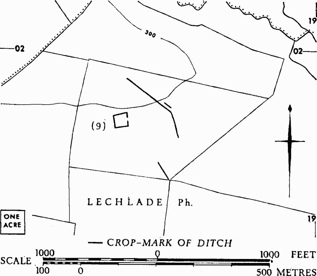
(9) Enclosure and Linear Ditches (SP 185018), are revealed by crop-marks N. of Lechlade Downs. The enclosure, on a gentle S.-facing slope, occupies about ⅓ acre.

Lechlade. (9) Enclosure and Ditches.
C.U.A.P., OAP AYI 18.
Oxon, VIII–IX (1943–4), 87–8.
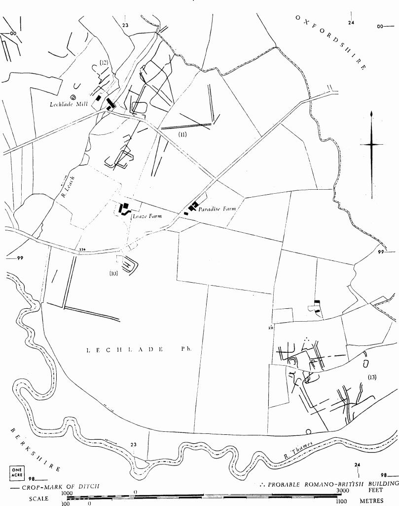
(10) Enclosure and Tracks (SU 228989), undated, show as crop-marks E. of the R. Thames and S. of Leaze Farm (map, p. 76).
N.M.R., OAP SU 2298/1/385–6; 2298/3/438–9.
(11) Enclosure, Tracks and Linear Ditches (SU 231997), undated, show as crop-marks extending over some 25 acres, E. of the R. Leach at Lechlade Mill. The enclosure occupies about 2/3 acre (map, p. 76).
OAP, Allen, 724. D. N. Riley, OAP V 7–8. C.U.A.P., OAP ZH 91.
(12) Enclosures, and Linear Ditches (SU 227998), undated, are revealed by crop-marks covering about 20 acres, W. of the R. Leach at Lechlade Mill.
OAP, Allen, 724. D. N. Riley, OAP V 7–8. C.U.A.P., OAP ZH 91–2.
(13) Romano-British Settlement (SU 238984) ploughed out, lies N. of the R. Thames and S.E. of Paradise Farm (map, p. 76). Enclosures, tracks and linear ditches show as crop-marks covering some 23 acres. Romano-British pottery and limestone slabs indicate the probable site of a building on slightly higher ground at the N. limit of the crop-marks (SU 23799861).

Lechlade. (10)–(12) Enclosures, Tracks and Linear Ditches. (13) Romano-British Settlement.
N.M.R., OAP SU 2398/2/480–2; 2398/3/477–9.
Oxon, VII (1942), 113, No. 10; VIII–IX (1943–4), 83. Information from Gloucester City Museum and Mrs. D. G. Stevens.
(14) Linear Ditches (SP 198006), undated, show as indistinct crop-marks W. of Bryworth Farm.
C.U.A.P., OAP DX 31.
(15) Linear Ditches (SP 206008), undated, show as indistinct crop-marks E. of Bryworth Farm.
O.S., VAP 70 167, 077–8.
