Ancient and Historical Monuments in the County of Gloucester Iron Age and Romano-British Monuments in the Gloucestershire Cotswolds. Originally published by Her Majesty's Stationery Office, London, 1976.
This free content was digitised by double rekeying. All rights reserved.
'Kingscote', in Ancient and Historical Monuments in the County of Gloucester Iron Age and Romano-British Monuments in the Gloucestershire Cotswolds(London, 1976), British History Online https://prod.british-history.ac.uk/rchme/ancient-glos/pp70-73 [accessed 5 May 2025].
'Kingscote', in Ancient and Historical Monuments in the County of Gloucester Iron Age and Romano-British Monuments in the Gloucestershire Cotswolds(London, 1976), British History Online, accessed May 5, 2025, https://prod.british-history.ac.uk/rchme/ancient-glos/pp70-73.
"Kingscote". Ancient and Historical Monuments in the County of Gloucester Iron Age and Romano-British Monuments in the Gloucestershire Cotswolds. (London, 1976), British History Online. Web. 5 May 2025. https://prod.british-history.ac.uk/rchme/ancient-glos/pp70-73.
KINGSCOTE
(11 miles W.S.W. of Cirencester)
The Chessalls (1) is a very large unwalled Romano-British settlement, associated with paved roads (cf. Whittington (2)). The nature of the finds suggests an early Roman origin, possibly military. Until 1942 an inscribed semicircular Oolite relief, probably depicting an equestrian Mars with worshippers, was built into a mediaeval barn at Calcot Farm (ST 839949); it is now in the Ashmolean Museum. (fn. 1) A stone votive tablet mentioned s.v. Wotton-under-Edge (p. 134), said to have been found on Symonds' Hall Hill, may have come from The Chessalls. Small finds from this parish and from Horsley, now in Stroud Museum and Bristol City Museum, are not closely provenanced. Romano-British pottery found c. 1890 near Kingscote Wood (a large area in the N.E. of the parish) is in Stroud Museum.

Monuments in Kingscote.
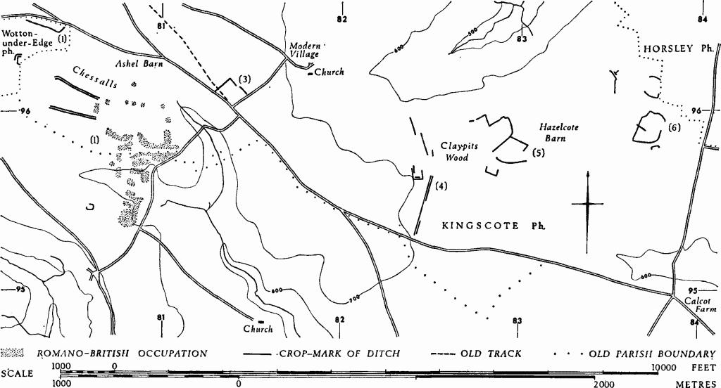
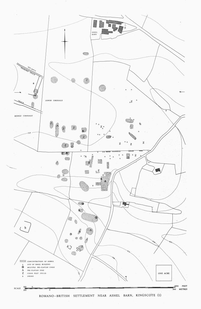
(1) Romano-British Settlement (ST 808953–807963– 810961), The Chessalls, covers at least 50 acres of arable ground S. of Ashel Barn; it is identified by numerous finds (plan in end pocket). The name 'Chesle' was associated with the site in 1772 (Camden, Britannia (ed. Gibson, 1772), I, 286); it is also used by Rudder. The site falls gently from about 725 ft. above O.D. and occupies both sides of an eastward-facing valley head, the southern of two depressions which join S.E. of the site and continue into the more steeply sided Hay Bottom. Gullies in the valley sides require in places a terraced setting for the former buildings. A spring (s) occurs on the N. side of the valley immediately above the 675-ft. contour. Beyond a gently domed plateau the N. part of the settlement occupies a broad and shallow depression which drains through withy beds into the northern valley head; N. of the withy beds only one building site is recorded. The field called Middle Chessalls probably marks the W. limit of occupation; on the E. side the limit appears to correspond roughly with the modern road since no significant remains have been found in gardens E. of the road; on the S., other building sites may await discovery. Today the S. edges of the two fields named Chessalls stand 4 ft. above those adjacent on the S.; this is the result of post-Roman lynchet formation along the old boundary with the former parish of Newington Bagpath. Similar lynchet formation has raised the E. side of Middle Chessalls almost 2 ft. above Lower Chessalls.

Romano-British Settlement Near Ashel Barn, Kingscote (1)
The sites of at least 75 buildings are identifiable on the ground, generally as concentrations of limestone slabs, sandstone tiles, mortar and associated dark soil containing pottery, quern fragments and other occupation debris. Near the middle of the W. side of Lower Chessalls field (around ST 80759610) there are slight traces of rectangular platforms. Some 80 yds. S.W. (ST 80619601), a long rectangular mound (a), 2 ft. high and aligned N.E.-S.W., with concentrations of building debris and potsherds, lies nearly at right angles to and S. of a probable track. A quarry on the N. of the same track is possibly Roman in origin. The outline of the building under the mound on the S. of the track is partly visible as a crop-mark on an air photograph (N.M.R., VAP ST 8096/1/102). A little further S., and approximately parallel with the first track, a paved road about 30 ft. across, with side ditches up to 3 ft. deep on the S. and less than 2 ft. deep on the N., approaches from the W., crossing Middle Chessalls field and narrowing sharply as it enters the settlement area.
In the S. of the settlement area, at (c) and (d), other air photographs show the crop-marks of two rectangular buildings. Further W., at (b), a sub-rectangular enclosure is similarly indicated.
Elsewhere in the settlement area some building sites appear to be aligned one with another, and there are also long spreads of debris. Potsherds, tiles and mortar found in large quantities near ST 80899565 probably mark the position of a large building (22), situated some 50 yds. N.E. of the spring (s); a prominent knoll at this point is a likely setting for an important building.
The record of finds begins in 1691 with an enamelled brooch (Camden, ed. Gibson, loc. cit.). In the 18th century a mosaic pavement, numerous coins and the head of a statue of Minerva, perhaps from a temple, were recorded. A stone coffin now in Kingscote churchyard was found in the 'Middle Chestles' in 1872; it lay less than 3 in. below ground with the head pointing exactly north. Widespread occupation debris including brooches and coins dating from the 1st to the 4th century have also been recorded; they include a Dobunnic silver coin.
The central and southern parts of the site have yielded much Claudian and early Flavian material: two military copies of Claudian asses, a coin of Nero, twelve brooches, a 'baldric' loop and an ornamental bronze knob, perhaps military, and samian ware. Finds of the 4th century (particularly the second half of the century) occur widely and probably represent the settlement at its maximum extent. A single sherd of grass-tempered pottery is reported. Of 226 coins available for study, 60 are later than Constantine I and the latest are of the House of Theodosius (up to 402).
Other finds include building stone, mostly Oolite (some ashlar) and a variety of sandstones; also imbrices, tegulae, and hypocaust tiles. Of bronze were brooches, finger-rings, bracelets, a nail-cleaner and tweezers, two pins (one spiral-headed), a late Roman buckle (Hawkes type I (b)), fragments of jugs, and clippings. An axe, a chisel and two styli were of iron. There were glass beads and fragments of glass vessels. Parts of twelve stone querns include one of Niedermendig Lava; there were also whetstones. Pottery includes samian (some of it Claudio-Neronian), and Severn Valley, Rhenish, Nene Valley, Oxfordshire, New Forest and calcitegritted wares. Oyster shells and a very few animal bones were also found.

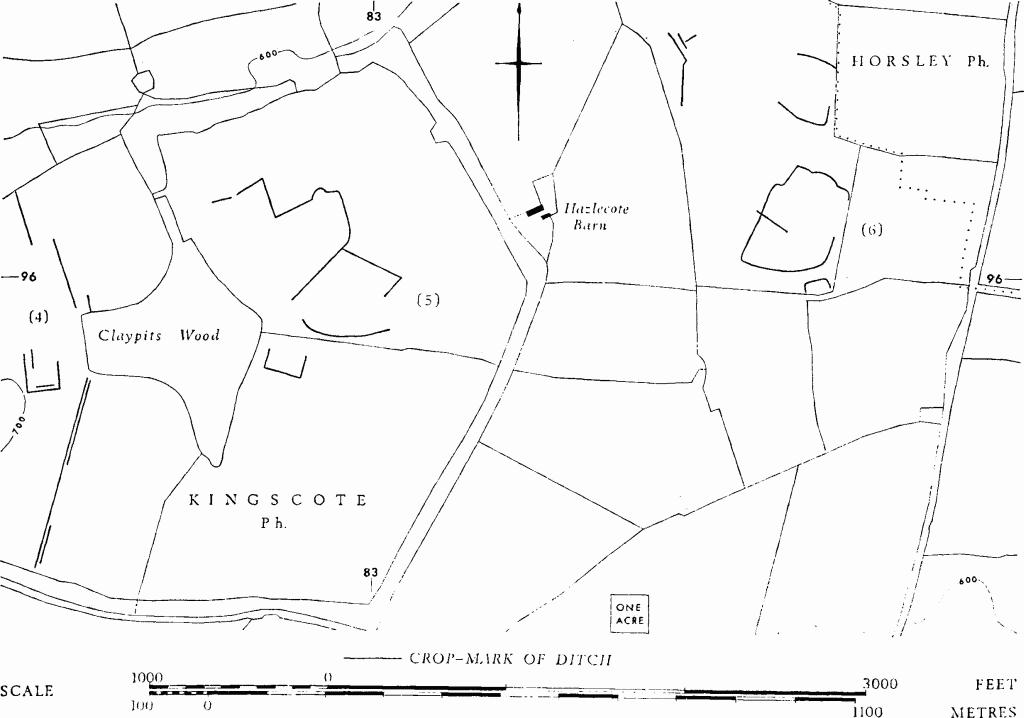
Kingscote. (4)–(6) Enclosures, Tracks and Linear Ditches.
Many of the finds are in Gloucester City and Stroud Museums; others are in private possession. The Minerva head is in Corinium Museum. A coin is in Liverpool Museum.

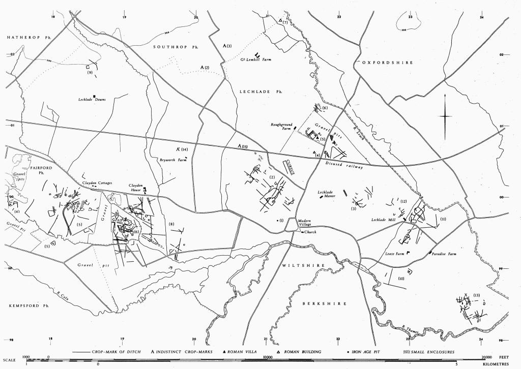
Monuments in Lechlade and Fairford.
N.M.R., OAP ST 8095/1/225–31; 8096/1/102.
Rudder (1779), 512. Kingscote family archives (Gloucestershire Record Office, D 471/C16), 30 Aug., 1872 (coffin). UBSS, II, iii (1925), 294. TBGAS, 72 (1953), 154–8; 91 (1972), 60–91. Toynbee (1964), 79 (head of Minerva). Lewis (1966), 126. Additional data from Messrs. J. Rhodes, L. J. Walrond, D. A. Mears, D. F. Mackreth; Professor F. Rainey of Pennsylvania Univ. (geophysical survey); Mr. N. Spry (excavation of road ditches, Middle Chessalls, 1971).
(2) Romano-British Burial (approx. ST 825972), S. of Kingscote Wood, comprised part of a skeleton with a 'Polden Hill' brooch, now in Stroud Museum; the grave was exposed in 1955 by soil-slip on a N.-facing slope near the stream.
TBGAS, 72 (1963), 205–7, and information from D. A. Mears.
(3) Enclosure (ST 81409610), undated, is partly revealed by a crop-mark 500 yds. S.W. of the church.
N.M.R., OAP ST 8095/37/174.
(4) Enclosure, Track and Linear Ditches (ST 825957), undated, show as crop-marks W. of Claypits Wood.
N.M.R., OAP ST 8295/1/245–50.
(5) Enclosures (ST 829960), undated, are partly revealed by crop-marks E. of Claypits Wood.
N.M.R., OAP ST 8295/2/251–6.
(6) Enclosures and Linear Ditches (ST 837962), undated, show as crop-marks E. of Hazlecote Barn.
C.U.A.P., OAP AXT 34–5.