Ancient and Historical Monuments in the County of Gloucester Iron Age and Romano-British Monuments in the Gloucestershire Cotswolds. Originally published by Her Majesty's Stationery Office, London, 1976.
This free content was digitised by double rekeying. All rights reserved.
'Fairford', in Ancient and Historical Monuments in the County of Gloucester Iron Age and Romano-British Monuments in the Gloucestershire Cotswolds( London, 1976), British History Online https://prod.british-history.ac.uk/rchme/ancient-glos/pp54-55 [accessed 23 November 2024].
'Fairford', in Ancient and Historical Monuments in the County of Gloucester Iron Age and Romano-British Monuments in the Gloucestershire Cotswolds( London, 1976), British History Online, accessed November 23, 2024, https://prod.british-history.ac.uk/rchme/ancient-glos/pp54-55.
"Fairford". Ancient and Historical Monuments in the County of Gloucester Iron Age and Romano-British Monuments in the Gloucestershire Cotswolds. (London, 1976), , British History Online. Web. 23 November 2024. https://prod.british-history.ac.uk/rchme/ancient-glos/pp54-55.
FAIRFORD
(8 miles E. of Cirencester)
An Iron Age terret has been recognised among finds from the area of a Saxon cemetery W. of the village. (fn. 1)
Fragments of five or six Iron Age pots were recovered in 1964 from a shallow ditch exposed in a gravel-pit (SP 171006); shoulder fragments exhibit fingertip impressions; closely spaced incised lines appear on other sherds. (fn. 2) Finds reported from an adjacent gravel-pit (SP 173006) include another Iron Age pot, much coarse Romano-British pottery, an inscribed sandstone weight (fn. 3) and a cross-bow brooch. (fn. 4)
Irregular enclosures and ditches seen in 1942, S.W. of the place where the former railway track ended, (fn. 5) cannot now be located.
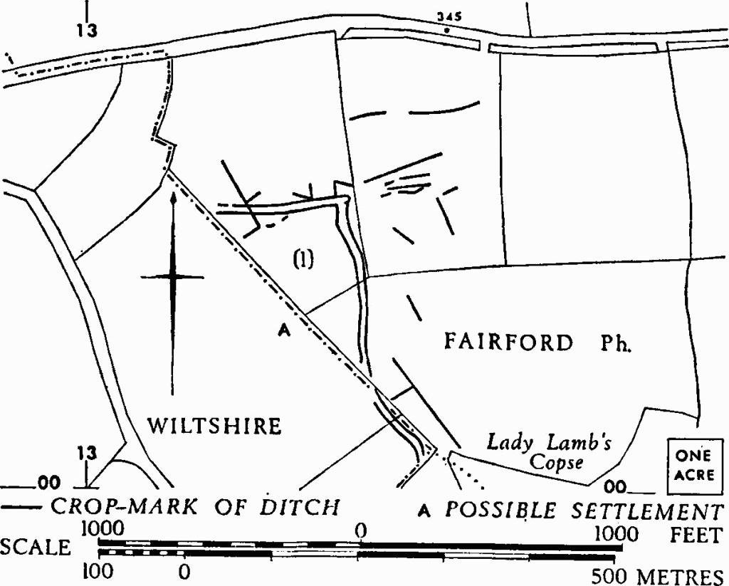
(1) Track (SP 133003), notably wide, undated, N.W. of Lady Lamb's Copse, shows as crop-marks on level ground in the plain. There are indications of settlement to the N.E., and also at 'A' to the S.W., across the county boundary with Wiltshire.
N.M.R., OAP SP 1300/1/404–7.

Settlements, Tracks and Enclosures at Fairford (3–6), Kempsford (4–5) and Lechlade (8).

Fairford. (1) Track.
(2) Enclosures and Linear Ditches (SP 154030), undated, N.E. of Obelisk Park, are revealed by cropmarks covering about 15 acres of level ground. Feature 'a', likely to be an enclosure of about 3 acres (Plate 66), has a ditch probably of defensive dimensions. Other enclosures are at 'b' and 'c'.
C.U.A.P., OAP ASM 61.

Fairford. (2) Enclosures etc.
(3) Double-Ditched Enclosure (SP 168004), undated, is partly disclosed by crop-marks on gravel N. of the R. Coln (Plate 58). The area enclosed is about ⅓ acre (map opposite).
C.U.A.P., OAP AM 32.
(4–6) Settlements, Enclosures and Tracks (SU 175999, 183998, 191996), N. of the R. Coln, undated, show as crop-marks extending over some 150 acres on gravel in the S.E. of the parish (map opposite). Monument (4) is illustrated on Plate 66; monument (6), Plate 61, is continuous with Lechlade (8).
C.U.A.P., VAP RC 8-M 272–5; OAP CD 051; AXP 61; AYI 6,13.
Oxon, VIII-IX (1943–4), 95, No. 4.
