Ancient and Historical Monuments in the County of Gloucester Iron Age and Romano-British Monuments in the Gloucestershire Cotswolds. Originally published by Her Majesty's Stationery Office, London, 1976.
This free content was digitised by double rekeying. All rights reserved.
'Farmington', in Ancient and Historical Monuments in the County of Gloucester Iron Age and Romano-British Monuments in the Gloucestershire Cotswolds(London, 1976), British History Online https://prod.british-history.ac.uk/rchme/ancient-glos/pp55-56 [accessed 5 May 2025].
'Farmington', in Ancient and Historical Monuments in the County of Gloucester Iron Age and Romano-British Monuments in the Gloucestershire Cotswolds(London, 1976), British History Online, accessed May 5, 2025, https://prod.british-history.ac.uk/rchme/ancient-glos/pp55-56.
"Farmington". Ancient and Historical Monuments in the County of Gloucester Iron Age and Romano-British Monuments in the Gloucestershire Cotswolds. (London, 1976), British History Online. Web. 5 May 2025. https://prod.british-history.ac.uk/rchme/ancient-glos/pp55-56.
FARMINGTON
(11 miles N.E. of Cirencester)
For general map, see p. 88, s.v. Northleach With Eastington. Monument (1) is in many respects similar to Barnsley (1).
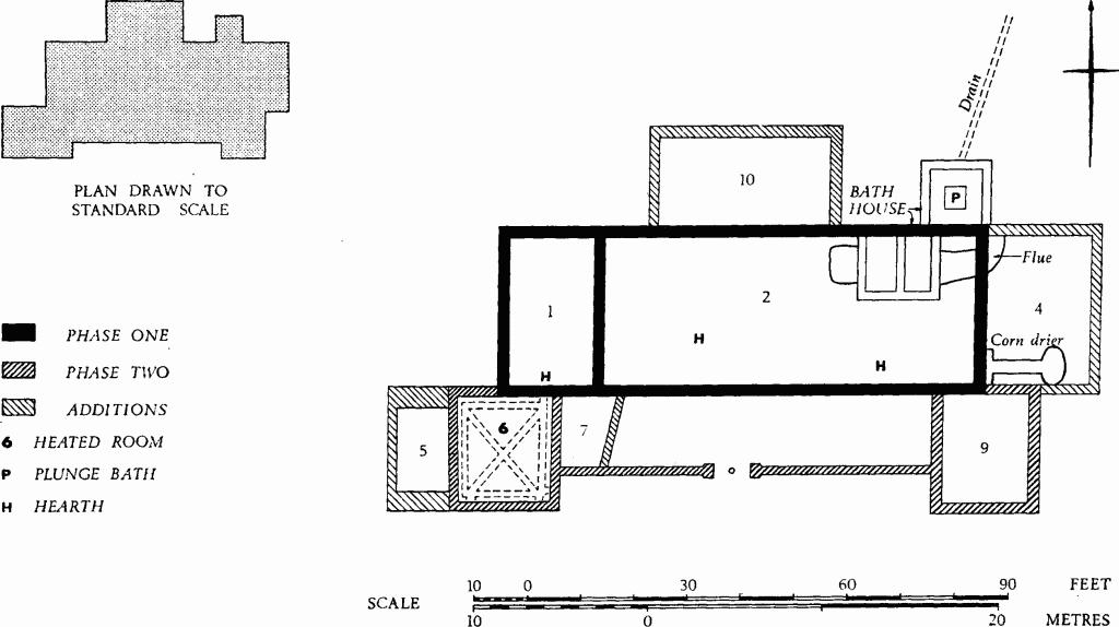
(1) Roman Villa (SP 13231585), Clearcupboard, in land formerly arable, was excavated by Mr. P. E. Gascoigne in 1964–7. The site occupies a small spur top of Inferior Oolite projecting N. from the valley side, 150 ft. below Norbury Hill-fort (Northleach (1)), in which there is a Romano-British settlement (Northleach (2)). Abundant water flowing from the junction of Great Oolite and Fuller's Earth immediately below the hill-fort was apparently channelled towards Clearcupboard. Plan, p. 56.
The basic structure, a rectangle 92 ft. by 31½ ft., was divided into two areas numbered 1 and 2 on the plan. Area 2, with a bath-house later inserted in one corner and with numerous hearths, fire pits and various kinds of floor, may have been only partly roofed. To it was added a corridor with symmetrical end rooms, one of them heated. The heated room (6) was subsequently rebuilt and the W. end of the corridor was obliquely partitioned. Other rooms were added; that at E. (4) contained a corn-drying oven and a raised floor of pitched stones; the other two added rooms (5 and 10) yielded no significant finds. The building appears to have evolved during the first three quarters of the 4th century.
The masonry in the two earlier phases of construction was generally of high quality, with the wall-cores of mortar-bound rubble, but the E. wall of room I was inferior and butt-jointed at the ends. The added rooms (4, 5 and 10) had masonry of poorer quality. The roof of the bath-house had tufa voussoirs and some walls had painted plaster. There was some reused moulded stone. Roof and ridging tiles were of local Oolite. In room 1 the wall plaster was coved at its junction with the opus signinum floor. Room 7 had painted plaster walls and a concrete floor. The plunge bath (P) had a floor of patterned red tiles. Building rubble found 55 yds. S.E. of the villa included a stone column from a hypocaust.
Finds include 23 coins ranging from 320 to 350, a pottery scatter including 2nd-century samian ware, a box flue tile stamped VLA, scraps of glass, the bolt of a barrel padlock and a spindle whorl. There were also probable cressets of stone, many large nails and a few horse-shoe nails. Bones included some of pig, sheep and cow together with antlers of red deer and a worked antler tine.
TBGAS, 88 (1969), 34–67; 90 (1971), 224.
Farmington. (1) Roman Villa, Clearcupboard.
(2) Romano-British Settlement (SP 129166), Chestles, now ploughed out, was discovered in 1970 by Mr. P. E. Gascoigne who kindly supplied information; it covered at least 2¾ acres. The name Chestles is on the Enclosure Map of 1707. Finds include 2nd-century samian and black burnished wares, 3rd to 4th-century pottery, and building stone.
(3) Rectangular Enclosure (SP 134167), undated, shows as a crop-mark on gently sloping ground. The ditch defines an area about 160 ft. square with an entrance in the centre of the S. side.
N.M.R., OAP (Baker) SP 1316/1–5; OAP 1316/6/368–9. TBGAS, 82 (1963), 215 (where it is called 'a small building').
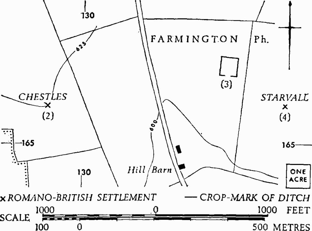
Farmington. (3) Enclosure. (2), (4) Romano-British Settlements.
(4) Romano-British Settlement (SP 13551660), Starvall, 200 yds. S.E. of (3), is indicated by pottery and building stone scattered in ploughsoil around a clump of trees. Pottery collected by Mr. P. E. Gascoigne includes a shell-gritted fragment in Iron Age tradition, a flagon-neck perhaps of the 2nd century, and Oxfordshire mortaria and colour-coated wares of the late 3rd-4th century.
TBGAS, 82 (1963), 215.