A History of the County of York North Riding: Volume 2. Originally published by Victoria County History, London, 1923.
This free content was digitised by double rekeying. All rights reserved.
'Parishes: Cold Kirby', in A History of the County of York North Riding: Volume 2, ed. William Page (London, 1923), British History Online https://prod.british-history.ac.uk/vch/yorks/north/vol2/pp43-44 [accessed 19 April 2025].
'Parishes: Cold Kirby', in A History of the County of York North Riding: Volume 2. Edited by William Page (London, 1923), British History Online, accessed April 19, 2025, https://prod.british-history.ac.uk/vch/yorks/north/vol2/pp43-44.
"Parishes: Cold Kirby". A History of the County of York North Riding: Volume 2. Ed. William Page (London, 1923), British History Online. Web. 19 April 2025. https://prod.british-history.ac.uk/vch/yorks/north/vol2/pp43-44.
In this section
COLD KIRBY
Carebi (xi cent.); Karebi (xiii cent.); Keerby (xvi cent.).
Cold Kirby is a parish of about 1,620 acres lying on the east slopes of the Hambleton Hills north of Coxwold. Nearly 700 acres are in cultivation, the chief crops being oats and barley. The subsoil is corallian beds. The grassland, covering 450 acres, (fn. 1) lies chiefly in the south-west of the parish, where is Cold Kirby Moor. Most of the common land was inclosed under an award of 1789. (fn. 2)
The parish at its western boundary reaches a height of about 1,000 ft. above the ordnance datum. It slopes down towards the east, where it narrows between two converging and deep wooded valleys, Nettledale on the north and Flassendale on the south. The village stands on the level moor some 800 ft. or 900 ft. above the ordnance datum. North of it is agricultural country with old quarries scattered among the fields. To the south are numerous plantations, among which stands Hambleton House.
The church of St. Michael is at the east end of the village, which consists of two rows of houses standing far back from the road; they are all of comparatively recent date. The school lies near the church. A field path leads hence across the valley to the village of Old Byland.
Manor
In 1086 COLD KIRBY was soke of the royal 'manor' of Easingwold. (fn. 3) It was granted by Henry II to Robert de Stutevill, whose heirs retained a mesne lordship. (fn. 4)
Before the end of the 12th century Richard Croer, the tenant in demesne, granted it to the Knights Templars. (fn. 5) In 1209 the master of the Temple claimed various lands from the lords of neighbouring manors as part of his manor of Kirby. (fn. 6) Kirby Flat, which probably lay between Cold Kirby and Old Byland, was found to belong to the master's manor, but was granted to the abbey of Byland at a yearly rent of 4s. (fn. 7)

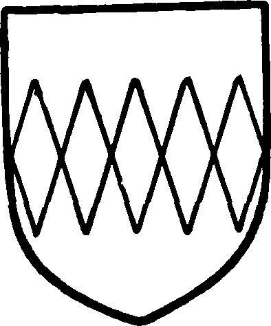
Stutevill. Argent a fesse indented gules.
When the Templars were dissolved in 1312 Cold Kirby passed to the Crown, (fn. 8) but was subsequently granted with other lands of the Templars to the hospital of St. John of Jerusalem. (fn. 9) It was attached to the preceptory of Mount St. John. (fn. 10)

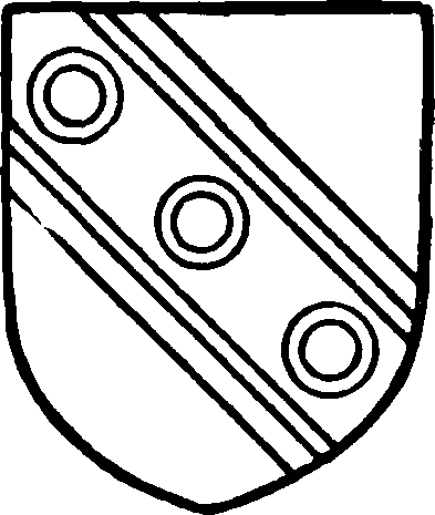
Dawnay, Viscount Downe. Argent a bend cotised sable with three rings argent thereon.
In 1543 land in Kirby which had belonged to the hospital was granted to the Archbishop of York. (fn. 11) The 'bailiwick or manor,' however, was not included, but was granted by Elizabeth in 1565 to William Haber and John Jenkins in fee. (fn. 12) Brian Askwith of Osgodby died in February 1589–90 seised of the 'manor or berewick' and was succeeded by his son William, (fn. 13) whose son William was a minor at his father's death in March 1600–1. (fn. 14) The manor remained in his family, (fn. 15) and on the death of the last William Askwith was divided between his granddaughters and co-heirs, Judith, who married Walter Hawkesworth, and Margaret, who married Francis Fawkes. (fn. 16) They sold it in 1706 to Henry Dawnay Viscount Downe, (fn. 17) whose family held it (fn. 18) until 1788, when it was sold by Lora Viscountess Downe to Charles Duncombe. (fn. 19) Thomas Slingsby Duncombe sold the manor in 1858 to Robert Tennant. (fn. 20) He sold it in 1880 to Mr. C. F. H. Bolckow, whose son Mr. H. W. F. Bolckow is the present lord of the manor.
Church
The church of ST. MICHAEL consists of a chancel measuring internally 16 ft. 9 in. by 12 ft. 11 in., nave 48 ft. 8 in. by 17 ft. 10 in., and a west tower 6 ft. 1 in. square. It was entirely rebuilt in 1841, the only trace of the original building being the font, which has a circular 12th-century bowl on a short octagonal stem with a chamfered base. In the upper edge of the bowl are the holes where the staples of the cover were fixed. Another fragment, a small stoup, is in the possession of the village schoolmaster. All the windows of the present building are wide single lights with round heads, and the south doorway has also a semicircular head. In the churchyard is a piece of an old coffin stone.
The tower contains two bells, the first of which bears neither date nor inscription; the second is inscribed in Roman letters 'God savee his church, 1665.'
The plate includes a silver cup of 1843, a paten of 1842 and a flagon of the same date as the cup.
The registers begin in 1749.
Advowson
This church was till the 18th century a chapel of Easingwold (fn. 21) (q.v.), and is mentioned as such in 1269. (fn. 22)
In the reign of Henry VIII Easingwold was annexed to the bishopric of Chester, (fn. 23) and for some time the bishop must have presented to Cold Kirby. In the beginning of the 18th century, however, the advowson had passed into other hands, possibly by sale. William Clark of Haxby presented in 1718 and H. Freeman in 1750. (fn. 24) During the latter half of this century the advowson belonged to Edward Lister of Bedale. He must have sold it before 1805 to the lords of the manor, (fn. 25) which it has since followed in descent.
In 1883 the church was annexed to the neighbouring benefice of Scawton. (fn. 26)
Charity
The Poor's Money consists of £18 8s. 7d. in the Thirsk Savings Bank. The interest is withdrawn every three years and applied in the distribution of money and coals.