A History of the County of Wiltshire: Volume 18. Originally published by Boydell & Brewer for Victoria County History, Woodbridge, 2011.
This free content was digitised by double rekeying. All rights reserved.
'Historic Parishes - Purton with Braydon', in A History of the County of Wiltshire: Volume 18, ed. Virginia Bainbridge (Woodbridge, 2011), British History Online https://prod.british-history.ac.uk/vch/wilts/vol18/244-285 [accessed 4 April 2025].
'Historic Parishes - Purton with Braydon', in A History of the County of Wiltshire: Volume 18. Edited by Virginia Bainbridge (Woodbridge, 2011), British History Online, accessed April 4, 2025, https://prod.british-history.ac.uk/vch/wilts/vol18/244-285.
"Historic Parishes - Purton with Braydon". A History of the County of Wiltshire: Volume 18. Ed. Virginia Bainbridge (Woodbridge, 2011), British History Online. Web. 4 April 2025. https://prod.british-history.ac.uk/vch/wilts/vol18/244-285.
In this section
PURTON
PURTON is a large parish which includes Purton village, Purton Stoke and various outlying settlements, several of which coalesced with the village as it expanded during the 20th century. (fn. 1) The village centre lies approximately 16 km. east of Malmesbury, 6 km. south of Cricklade and 7 km. north-west of Swindon town centre. The name, referring to a settlement by a pear-tree, was first recorded in 796, when Purton was described as lying to the east of Braydon forest. (fn. 2) Parts of the parish lay within the bounds of the forest, including the tithing of Braydon, formerly the Duchy woods in the central part of the ancient forest, (fn. 3) which became a separate civil parish in 1866. (fn. 4) Most aspects of Braydon's history are treated separately in the last section of this account. The other sections are concerned with the parish as it existed after 1866 and before 1984, when further changes were made to its boundary. (fn. 5)
Boundaries
The parish is approximately rectangular, but with long fingers of land extending westward from the northwestern and south-western corners. (fn. 6) To the east of Purton lie Blunsdon St Andrew, and what was formerly part of Rodbourne Cheney parish and became Haydon Wick; to the north lies Cricklade St Sampson, and to the south lie Lydiard Millicent and, at the south-west corner, Brinkworth. Braydon tithing occupies much of the area between the two fingers of Purton land, and the remainder is another strip of land which belonged to Cricklade St Sampson. Purton's more northerly finger, extending westward from Purton Stoke, derives from two long narrow strips of Braydon forest called Keynes rag and Poucher's rag after heirs of Adam of Purton. (fn. 7) In 1637 the vicar of Purton successfully resisted a claim that the rags were part of Cricklade St Sampson parish. (fn. 8) In 1879 Purton covered 6,464 a. and Braydon 1,483 a., a total of 7,948 a. (fn. 9) In 1984 the intruding strip of Cricklade St Sampson land was transferred to Purton parish, and small areas of land along the southern boundary at Green Hill were transferred from Purton to Lydiard Millicent. Purton contained 2,822 ha. (6,973 a.) in 1991. (fn. 10)
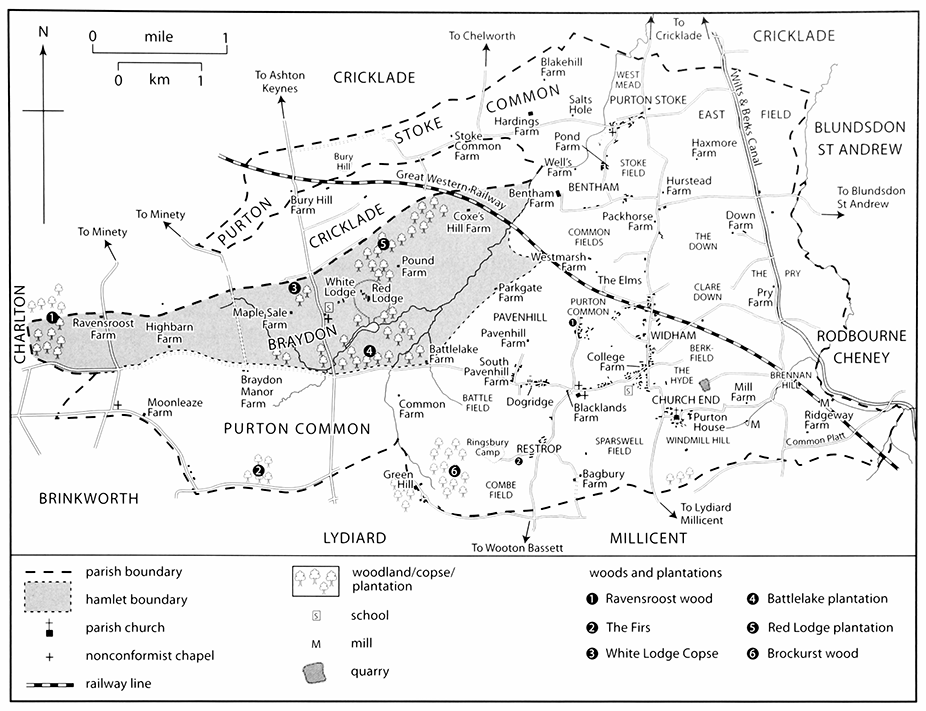
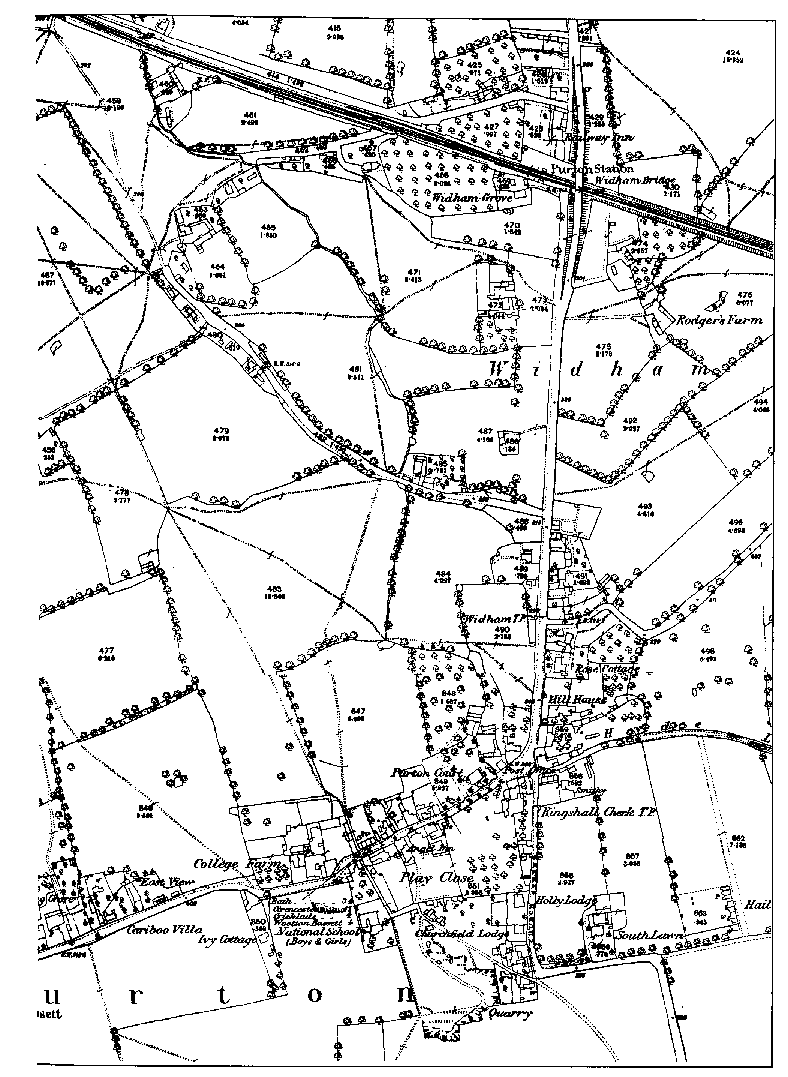
MAP 19. Purton and Braydon c. 1875. Most settlement developed in the east of the parish; the western half lay within the ancient boundaries of Braydon forest. The tithing of Braydon became a separate civil parish in 1866. For maps of Church End and other areas of Purton see following pages.
The late Anglo-Saxon bounds of Purton are purported to be set out in a Latin redaction of an Old English boundary clause. (fn. 11) The territory described has been shown to correspond in most respects to the later parish, including Braydon tithing but excluding Purton Stoke and the rags, its westward extension, although boundary points within the forested area may not have remained static. (fn. 12) A two-day perambulation in 1733 of the parish boundary, including Braydon tithing, Purton Stoke and the rags, was described in minute topographical detail. (fn. 13) New boundary stones were erected in 1999 to celebrate the millennium. (fn. 14)
Purton's pre-1984 boundary follows the Ray along its entire eastern length, and elsewhere utilises streams, including a length of the Key, field boundaries, and roads and droveways leading into the forest.
Landscape
The Corallian limestone ridge, which outcrops intermittently across north-west Wiltshire from Westbury to Highworth, is Purton's most prominent landscape feature. (fn. 15) It forms an escarpment running south and east from its highest point, 144m at Pavenhill, on which the village High Street, Dogridge, Restrop and Church End all stand. Disused quarries, where the stone was won for local buildings, are located south of Playclose, at the Hyde and elsewhere. (fn. 16) In places, north and south-east of Restrop, behind North View hospital and at Common Platt, Kimmeridge Clay overlies the Corallian; and beneath it at Ringsbury and south of Restrop a brownish-grey sandstone outcrops, known as the Ringsbury Spiculite Member or Rhaxella Chert. North of the Corallian escarpment, from Widham to Purton Stoke and the Ray, and westward below Pavenhill and Ringsbury into the former forest areas, the topography is uniform Oxford Clay, typically between 82m. and 100m. above sea level, but rising to 113m at Bury hill and 105m. near Blakehill farm. Alluvial deposits have formed along the Ray and the Key, and the Ray leaves the north-east parish boundary at about 80m. A saline well, Salts Hole, west of Purton Stoke village has been exploited as a spa. (fn. 17)
Communications
Roads (fn. 18)
It is very likely that the medieval road
between Oxford and Bristol, via Faringdon and
Malmesbury, passed through Purton, presumably
following a line similar to that mapped in 1675. (fn. 19) The
tithing, later parish, boundary with Braydon between
Battlelake farm and Braydon Manor farm is set back
from this road as if fossilising the line of a medieval
trench or clearing alongside a highway through
woodland where robberies might occur. (fn. 20) The road in
1675 entered the parish by a stone bridge over the Ray
north of Mouldon hill, continued along Collins Lane,
High Street and Dogridge, whence it descended to
traverse Braydon forest. (fn. 21) Use of this road may have
declined in the 18th century and it was not turnpiked.
A road running north from Wootton Bassett to Cricklade entered Purton at Restrop, turned east at Dogridge to follow the line of the old main road along High Street, and at Lower Square diverged north down the hill to Widham, past Purton Stoke village and on to Cricklade. It was turnpiked in 1790 and disturnpiked in 1879. (fn. 22) Tollgates were erected near where it entered and left the old main road; the tollhouse at Collins Lane Gate on Widham survives and still displays a table of fees. (fn. 23) A road further east ran parallel, linking Common Platt and Church End to Cricklade. It allowed access to agricultural land and the Wilts. & Berks. canal was later built alongside it. Minor north–south roads crossed Braydon forest, through the fingers of Purton land, and one, between Wootton Basset and Cirencester via Ashton Keynes, was turnpiked between 1810 and 1863. (fn. 24) The parish had many internal lanes, including Mud Lane, an ancient track leading from Ringsbury camp to Restrop, (fn. 25) and Hoggs Lane, first mentioned in the 1200s, (fn. 26) one of several lanes in central Purton. Bentham Lane turned west from the Cricklade road, north up Cow Street and west into Purton Stoke street.
Canals
The North Wilts. canal, opened in 1819,
linked the Wilts. & Berks. canal north of Old Swindon,
with the Thames & Severn canal, which it joined at
Latton. (fn. 27) The canal crossed the Ray on the Moredon
aqueduct. (fn. 28) Traffic ceased in 1906 and it was closed in 1914.
Railways
The Cheltenham & Great Western
Union Railway broad gauge line was opened in 1841,
with a station at Purton, as a branch from the Great
Western Railway trunk line to serve Gloucester and
Cheltenham. Its course runs diagonally through the
centre of the parish from south-east to north-west
corners. It was transferred to the GWR in 1844. After
1850 it became the main railway link between London
and south Wales. (fn. 29) Although Purton station was closed
in 1964, (fn. 30) the line remains open. In 1883 the Swindon
and Cheltenham Extension Railway Company opened
a second line through Purton, which traversed the
eastern edge of the parish, with a station named
Blunsdon (although just within Purton parish), which
opened in 1895 mainly for milk traffic. The company
became the Midland & South-Western Junction
Railway Company in 1883 and was absorbed into GWR
in 1923. (fn. 31) Blunsdon station was closed to passengers in
1924 and completely in 1937. A section of the line was
re-opened as the Swindon and Cricklade railway in
1978, centred on Blunsdon station, and enthusiasts are
working to restore the tracks and rolling stock. (fn. 32)
Population
Medieval Purton was a populous and wealthy parish. In 1086 there were 45 households of villein, bordar or cottar status, and five of demesne slaves. (fn. 33) There were 45 taxpaying households in 1332; (fn. 34) and in 1334 Purton paid 140s. out of a total of 216s. in tax collected in Staple hundred. (fn. 35) Purton's total of 318 adults paying the 1377 poll tax ranked it the twelfth most populous fiscal unit in Wiltshire. (fn. 36) In 1576, 33 households were assessed for a total £12 10s. 8d. tax, higher than any other community in the combined hundreds of Highworth, Cricklade and Staple. (fn. 37) In 1676 there were c. 700 adult communicants in the parish. (fn. 38) By 1801 the total population was 1,467 inhabitants and in 1821 1,766. Unlike most rural Wiltshire communities, numbers rose steadily throughout the 19th century. The 1841 total of 2,141 included 75 labourers building the Great Western Railway and 76 persons in the Cricklade and Wootton Bassett Union workhouse. The 1871 total, 2,344, was attributed to the increased number of mechanics employed at Swindon railway works; population peaked at 2,432 in 1891. The parish total included a separate figure for Braydon's inhabitants from 1821 when 70 people lived there. In the 20th century the population continued to rise steadily from 2,525 in 1901, to 2,678 in 1951, (fn. 39) 3,295 in 1961, 3,630 in 1971, 3,873 in 1981, 3,879 in 1991. (fn. 40)
SETTLEMENT
Early Settlement
Two Iron Age hillforts lie within the parish. Bury Hill, a univallate fort reduced by ploughing, stands on a low eminence remote from the main areas of settlement two miles west of Purton Stoke. (fn. 41) Ringsbury camp, west of Restrop, is bivallate with an eastern entrance and well preserved banks and ditches. It occupies a commanding site overlooking Braydon forest to the west. (fn. 42) Neolithic tools found within the fort suggest its reuse from earlier prehistory, (fn. 43) but very little other evidence of prehistoric activity in the parish has been found.
Building debris and pottery imply Romano-British settlement at various locations, east of Purton Stoke and near Church End south and south-west of the former Fox inn; (fn. 44) a Roman lamp was found c. 1890 in Purton churchyard. (fn. 45) The principal focus of later Roman activity appears to have been in the Dogridge area. Here an industrial site producing pottery from at least four kilns, probably for a short period in the 2nd century, was excavated in 1975. (fn. 46) It may have been associated with or superseded by one or more highstatus residences furnished with mosaics which were discovered further north between Dogridge and Pavenhill in an area named Black Lands in 1744. (fn. 47) To the east a late-Roman walled cemetery was discovered in 1987 on the site of Purton workhouse (North View hospital). Finds included opulent grave goods and a stone ossuarium containing cremated remains inside a glass vessel within a lead container inscribed with Christian symbols. (fn. 48)
An inhumation cemetery of the early Anglo-Saxon period was revealed during quarrying at the Fox from c. 1900; grave goods found in 1912 suggest that it was in use in the 7th century or later. (fn. 49) If the dating evidence is correct this cemetery may have been contemporary with the first acquisition of Purton by Malmesbury abbey in 688. (fn. 50)
Later Settlement and Built Character
From the 7th century to the 16th, Purton was among the largest and most important, if rather unwieldy, of Malmesbury abbey's possessions. Its settlement history in the medieval period is complicated by two factors. By the early 13th century, the abbey, while retaining considerable demesne, had leased out a substantial porton of its manor to a knightly family, who also held the serjeanty of the forest and the manor of Chelworth in Cricklade. (fn. 51) The submanor itself fragmented and as a result the abbey retained only a loose hold on many aspects of life in Purton; the new estates became, in effect, distinct manors with their own demesne. In consequence Purton parish embraced settlements of various types, including hamlets such as Purton Stoke and Pavenhill, moated sites at Widham and Bentham, and high-status houses at Church End, Restrop and elsewhere. Alongside these holdings the abbey retained, along with the overall lordship, some demesne land, and control of the mills and the church. A second complicating factor was Braydon forest, much of which occupied the western third of Purton parish even after the forest bounds were reduced in 1300. Largely unpopulated, it was a resource exploited in different ways by the abbey, the Crown, the manorial lords and their tenants; their various rights and prohibitions affected not only parish government, but also the pattern of settlement. The forested area was regarded as a tithing of Purton, and some aspects of Braydon tithing's history are treated separately.
The location of the Anglo-Saxon cemetery some 2km. east of its late-Roman predecessor, and Malmesbury abbey's decision to establish its demesne premises nearby, and perhaps found a church there also, (fn. 52) may be indications that the main area of settlement shifted eastwards along the Corallian escarpment between the 5th and 7th centuries. The subsequent isolation of Church End, leaving manor house and church some 600 m. south-east of High Street, is best explained by the development of Purton in the Middle Ages as a thoroughfare village along a main road. Away from these two foci, medieval hamlets and farmsteads were scattered through the parish, both on the Corallian, at Restrop, Bagbury, Pavenhill and elsewhere, and on the clayland to the north, at Widham, Bentham and Purton Stoke. (fn. 53) Several clayland farms, at Widham, Bentham and Pond Farm, Purton Stoke, were moated, and there is archaeological evidence of medieval settlement desertion at Common Platt and Purton common. (fn. 54) In the early 17th century there were at least 149 agricultural holdings, 28 in High Purton, 29 in Restrop and Pavenhill, 36 in Westmarsh and Widham, and 29 in Purton Stoke and Bentham, (fn. 55) and more than 60 recently-built cottages housed poorer inhabitants. (fn. 56) The inclosure of the common lands in the 18th century caused many more scattered farmsteads to be built in outlying areas, surrounded by their newly allotted fields and closes.
The parish experienced considerable development in the 19th century, particularly after the coming of the railway in the 1840s. Among many small homes were Wheatfield Cottages, built east of Church End at the Fox in c. 1884. (fn. 57) The break-up of the Shaftesbury estate in 1892, when much of the land was sold as small building plots with road frontage, also contributed to the 'suburbanisation' of Purton, which continued throughout the 20th century.
Purton's prosperity throughout its history is reflected in more than fifty listed buildings and monuments scattered throughout the parish. (fn. 58) Its architectural heritage was described in 1894 as one of the most interesting in north Wiltshire for the mansions and farmhouses of the gentry, 'representing in well-nigh unbroken succession the various stages of domestic architectural development from Elizabethan times'. (fn. 59) Houses built for those of middling social rank in the last two centuries reflect every phase of modern suburban development from late 19th century red brick terraces to inter-war bungalows and council housing and late 20th-century cul-de-sacs. (fn. 60)
Surviving farmhouses and buildings dating from the late 16th to the early 19th century conform to the local vernacular with limestone rubble walls and stone slate roofs. The higher status manor and farmhouses, notably Manor Farm, Restrop and Bentham House, are built with dressed stone and reflect national architectural fashions. From the mid 19th century brick was used for many smaller homes. Much 20th-century development was piecemeal and apparently built with little overall planning control, resulting in a lack of coherence to the appearance of the main village streets. Recent building campaigns have been more sympathetic to local traditions, notably at Thompson's Close built on the former garage site on the corner of High Street and Restrop Road.
In describing the built environment of the parish it will be convenient to consider first the early village nuclei of Church End and High Street; then the outlying settlements, including those now engulfed in suburbs; and finally Purton Stoke village. Buildings associated with the major manorial and estate owners receive separate treatment as part of Purton's manorial history.
Church End
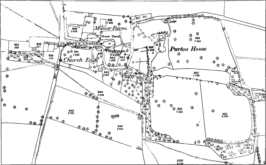
MAP 20. Purton, Church End in the late 19th century.
Standing aloof from the main built-up area of Purton, Church End consists of the church, approached by a straight avenue flanked by the manor house, its long range of farm buildings, and cottages. In the Middle Ages a number of farmsteads apparently clustered around the church. A recently-built vicarage stood at the entrance to the church in 1276: to the south two other houses shared its plot, and the hall, a dwelling house and crofts belonging to Malmesbury abbey lay to the east. (fn. 61) The rent from Chamberlains, later Purton House, funded the office of Malmesbury abbey's chamberlain. (fn. 62) The Buthaye, 4 Church End, stood on church land called Parson's hey or Court close, where by the 16th century lay a church house, known as Church Inn in the 17th century, when the complex of buildings included a grange, brewhouse, malt kiln, cottage and outbuildings belonging to the Gleed family. (fn. 63) Following the dissolution of Malmesbury abbey and the sale of the manor and rectory estates, Church End was redeveloped: the manor house was rebuilt by Edmund Bridges, Lord Chandos, in the later 16th century; (fn. 64) 3 Church End was built as a farmhouse in the 17th century; and Thomas Gleede, a wealthy yeoman and former tenant of the abbey, built a farmhouse, now called the Milk House, in 1656, (fn. 65) on land which was once part of the abbey's demesne. (fn. 66) Church End has apparently changed little in the intervening centuries and was designated a conservation area in 1974. (fn. 67)
High Street
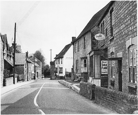
38. View of Purton's High Street, looking towards the Angel Inn, around which settlement was concentrated in the 18th century.
Purton's narrow high street follows a meandering course for c. 1 km along the limestone ridge. Settlement grew up around the crossroads at the east end of High Street (Lower Square). It was concentrated around the Angel inn in the 18th century and extended west to just beyond Play Close on the south side of the road. Between Play Close and the junction with Restrop Road further west (Upper Square), arable land lay to the south and farmsteads were scattered along the north of the street with small clusters of buildings at the junctions with Hoggs Lane, or Side of Pipney, and the lane to Pavenhill. (fn. 68) Little had changed by the early 20th century, although there was some infilling on both sides of the street. (fn. 69) The older houses are either of local rubblestone sometimes dressed with brick, or of brick. Tudor Cottages, 20–21 High Street, date to c. 1600 and 7 High Street is dated 1673. (fn. 70) College farmhouse and the Court (now Purton Court, 3 High Street) are discussed below. (fn. 71) Many new buildings appeared between the late 18th and mid 19th centuries, some with shallow slate roofs, and a landmark was established at the corner of Lower Square in 1879 when the tall free-style Workmen's Institute was built. During that period several farmhouses were rebuilt in fashionable style, and most were detached from their lands to become gentry residences for wealthy local families or incomers. (fn. 72)
MAP 21. Purton, the centre of settlement in the late 19th century.
Hallidays, 24 High Street, was named after the Halliday or Holliday family: (fn. 73) '1784 R x H' is carved on an attic beam of this 18th-century farmhouse. In the 19th century it was redesigned as a gentry residence and a farm building became a coach house. It belonged to Richard Garlick Bathe in 1840 and was occupied by the Misses Bathe. (fn. 74) When it was sold in 1920, the coach house had become a 'motor house'. (fn. 75) Hallidays was part of the Bathe estate centred on High Street inherited by the Brown family. The 1920 sale of the estate led to development in the area between Upper Square and along the south side of High Street: parts of Blacklands farm were sold to Cricklade and Wootton Bassett Rural District Council between 1920 and 1945 to build council housing from Pavenhill in the west, along Dogridge and High Street to Church End. Hoggs Lane leads north to Purton Common. (fn. 76) Infilling took place on both sides of High Street in a variety of building styles and several housing estates and cul-de-sacs were built behind the street.
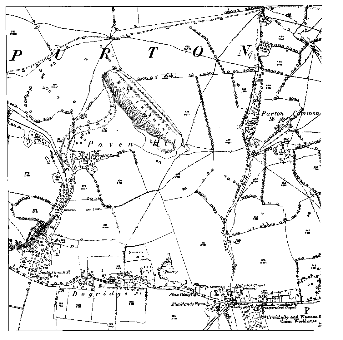
Dogridge and Pavenhill
In the decades around 1800 building took place on each side of Pavenhill between the junction with Hoggs Lane and the turning to Upper Pavenhill. On the south side a detached house dated 1767 stands alongside a terrace of cottages dated 1896 and the Cricklade and Wootton Bassett workhouse which was built in 1837. The Primitive Methodist chapel built in 1856 at the south end of Hoggs Lane, farm buildings altered for residential use and cottages with 20th-century modifications survive, together with infill housing of varied periods and styles. (fn. 77)
There was settlement at Pavenhill by the 13th century, (fn. 78) when the homesteads of the Malreward and Walerand families stood there. (fn. 79) In the early 1700s there were several farmsteads along the main highway leading past Lower Pavenhill farm, the home of the Gleed family. There was settlement on both sides of the road leading to Upper Pavenhill farm from LowerPavenhill farm, which dates from the 17th and 18th centuries and has stables dated 1777 constructed of diaper brickwork for Thomas Plummer. In c. 1990 an early 17th-century barn was converted into a dwelling house. (fn. 80) The present buildings along the lane to Upper Pavenhill date from the later 18th century onwards and are generally of rubblestone construction. (fn. 81) Small cottages have been knocked into larger homes and later 20th-century and early 21stcentury infill has been constructed out of similar materials to blend in with older buildings. In the early 20th century Pavenhill was known as 'Copper Street' because it was the poorer end of the village. (fn. 82)
Southern Purton
Restrop and Bagbury both grew up around farmsteads on the stonebrash soil to the south of the main village. Restrop is on an ancient track leading from Ringsbury camp. (fn. 83) The name, first recorded in 1208, (fn. 84) is derived from a personal name and thorp, the Old English for settlement. (fn. 85) In the 13th century the Radesthrop family, free tenants of Malmesbury abbey, were its principal inhabitants. (fn. 86) Restrop house was rebuilt as a mansion by the Digges family c. 1600. (fn. 87) Bagbury is first recorded in 1250, when Nicholas of Baddebyr, a knight, lived on a 2virgate freehold estate. (fn. 88) Neither hamlet grew in significance, (fn. 89) and both remain small clusters of cottages around their ancient farmsteads.
There was settlement at Common Platt by the later Middle Ages. (fn. 90) The hamlet grew larger in the 19th century. (fn. 91) It consists mainly of mid 20th-century houses and bungalows, (fn. 92) and cul-de-sacs of late 20th-century housing south-east of the Foresters' Arms at Common Platt and Sparcells, built as part of Swindon's western expansion. (fn. 93)
The Widham area
There were several farmsteads to the north of the main village. At Widham a moated site was occupied in the later Middle Ages, (fn. 94) and there was settlement in the area of Common farm. (fn. 95) Widham farm was built c. 1600. (fn. 96) Further north along Cricklade road Pound Farm (fn. 97) and the cottages at Packhorse Corner (fn. 98) were built in the 17th century. On the road leading north east from Church End, Pry farmhouse (fn. 99) and Crosslanes farmhouse (fn. 100) were built in the 17th century, and buildings at Packhorse, Hurstead and Haxmore farms in the 18th and 19th centuries. (fn. 101) Park House Farm was built in the late 18th century, apparently on the site of an earlier farmstead. (fn. 102) By the early 18th century there was housing around Bowshot along Witts Lane and along the west side of the lower reach of Hoggs Lane. (fn. 103) Terraces of red brick houses were built along Station Road in the late 19th century and in the 20th and early 21st centuries cul-de-sacs of modern homes were built between Station Road and Purton common. By 1650 there was a farmstead at West or West Marsh, (fn. 104) later known as Purton Common Farm. (fn. 105)
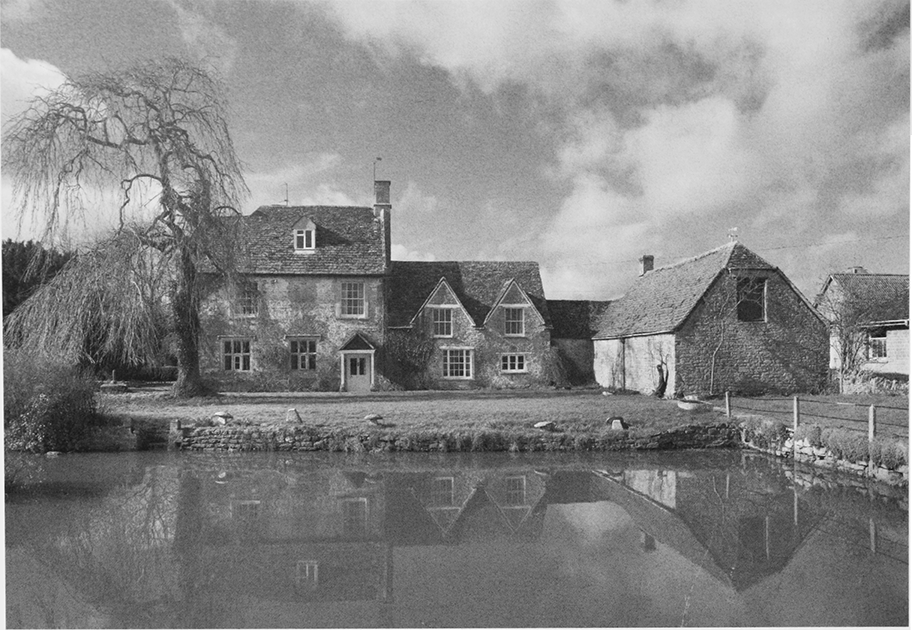
39. The Victorian front of Bentham House, an 18th-century farmhouse almost completely rebuilt by the Sadler family.
Purton Stoke
Occupying the northern, largely clayland, portion of the parish, Purton Stoke stands apart from the main village, c. 3.5 km. north of the parish church. The earliest part of the settlement, first recorded in 1257, (fn. 106) was built on an area of raised ground, which curves to the south west along the bank of the Key and overlooks Stoke common. Here, south of the junction between Pond Lane and the west end of Stoke street, several cottages and farmsteads are arranged around what may once have been a village green. One former farmstead dates to c. 1600, and to the south-east of the junction stands No. 34, an 18th-century rubblestone house with long timber lintels over the windows. No. 35 is of a similar date. To the north-east of the junction, Purton Stoke House dates to c. 1800. A farmhouse belonging to the Shaftesbury estate, it was later used as a private school, and known as Stoke Villa by 1875. (fn. 107) Further west within a small garden on Stoke common, is Salts Hole, an octagonal well house designed in playful Gothic style and built of rendered brick over the saline spring in 1859. (fn. 108)
South of the village, approached by Pond Lane and Cow Street, stand the moated Pond Farm and Bentham House, both associated with major Purton landowners. (fn. 109) Land to the south and east of Bentham House show the ridge and furrow pattern of preinclosure arable cultivation. In 1640 Thomas Shayle owned Benthams, and a cottage called Redlands. (fn. 110) In the 18th and 19th centuries the hamlet consisted of a group of farms, (fn. 111) including Bentham farm, (fn. 112) New farm and Stoke Common farm. (fn. 113) By 1941 there was another farm called Dairy farm. (fn. 114)
Stoke street stretches east along a low ridge from the junction with Pond Lane. Around 20 farmsteads were laid out along both sides by the early 18th century. (fn. 115) The street now has a mix of limestone rubble and brick buildings. The farmhouses were built in the local style in the 18th and 19th centuries. Of the 18th century are Manor Farmhouse, set end on to the street, no. 17, Dairy Farmhouse, of brick with long timber lintels, and Stoke Cottage which has an early-to-mid 19th-century extension. No. 38, built of rubblestone with a formal front of three bays, dates to c. 1800. Cottages along the street appeared mainly in the 19th and early 20th centuries. At the east end, Stoke street crosses the road to Cricklade and becomes Newths Lane. The Bell inn was built in the early 19th century to the north-west of the crossroads, and a corrugated iron reading room south-east of them in 1909. (fn. 116)
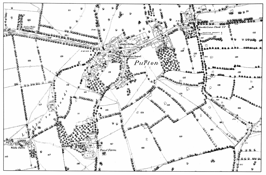
MAP 22. Purton Stoke in the late 19th century
Because it was further from the railway station, less development of suburban character occurred at Purton Stoke in the 19th century than around Purton village. However, the farming community of the early 20th century had changed to one of commuters by the early 21st century. The 1928 sale particulars for Dairy Farm suggested that the house might become a 'gentleman's residence'. (fn. 117) Subsequently other farmhouses have been converted to dwellings and new houses have been built between older ones along the street, including semidetached council housing at the east end. (fn. 118)
North-west of Purton Stoke, Blakehill airfield was built in 1942–3 on 580 a. of land belonging to Blakehill farm in Purton and Whitehall farm in Cricklade. It was used for D-day and other Second World War operations and closed in 1946. Afterwards it was used for training, and later a GCHQ monitoring station was set up there. The site was partially cleared in the 1970s and the runways used as hardcore to build the M4 motorway. In 2000 it was acquired by Wiltshire Wildlife Trust and became the subject of one of Europe's largest grassland restoration programmes. (fn. 119)
MANORS AND OTHER ESTATES
Malmesbury abbey owned Purton from the 7th to the 16th century, and in the Middle Ages leased much land to tenants. When the main lay submanor was divided between heirs c. 1266, each claimed manorial status, and three manors emerged, all probably focused on the area of the church and Church End: Purton Keynes, Purton Paynel (later Poucher), and Gascrick. These co-existed with the abbey's rectory estate and with smaller freeholds, at Bentham and Pond farm in Purton Stoke, and in the south of the parish, at Pavenhill, Restrop and elsewhere. By the 16th century Purton Poucher (formerly Paynel), had apparently combined with Purton Gascrick and Wootton manor and these lands were then sold piecemeal; the rectory estate and Bentham, a Purton Stoke freehold, were held with Purton Keynes manor. The post-medieval descent of the manors is confusing because holdings which were sold off carried certain manorial rights with them and the names of the principal manors were then attributed to more than one portion of their former lands. The fragmentation by sale of the Purton Keynes estate c. 1609 added further complications. A new landholding élite emerged which accumulated estates in the parish, principally the Sadler, Cooper (Shaftesbury), Maskelyne and Bathe families. These holdings in turn were broken up in the later 19th and early 20th centuries, permitting piecemeal suburban development.
In the following sections each manor of medieval origin is described in turn, and then the estates that emerged after 1609 are considered. Ownership of Braydon, which lay partly in Purton parish, receives separate treatment as part of the history of Braydon tithing.
MALMESBURY ABBEY'S MANOR
As part of Malmesbury abbey's accumulation of lands in north Wiltshire under Abbot Aldhelm, the West Saxon king Caedwalla granted the abbey a 30-hide estate 'on the east side of Bradon wood' in 688. (fn. 120) This can be equated with all or part of the 35-hide estate at Purton taken from the abbey by the Mercian king Offa and restored to it by his son Ecgfrith in 796. (fn. 121) The abbey may twice have lost possession of Purton again, before 854 and in the mid 10th century. (fn. 122) By 1066 Malmesbury had regained ownership and Purton remained an important constituent of the abbey's Wiltshire landholdings until its dissolution in 1539. (fn. 123) At that time income from the Purton estates was assigned to the abbot's exchequer, and the offices of cook, chamberlain and refectorian. (fn. 124)
From an undated boundary clause it is clear that Malmesbury's pre-conquest property at Purton at one time included much of the later parish but excluded Purton Stoke. (fn. 125) By 1086, however, since no other landholding in Purton is described in Domesday Book and none is required by the geld roll total for Staple hundred, the abbey's estate was probably computed to include Purton Stoke and any land supporting a possible early minster church. (fn. 126) Keynes rag and Poucher's rag, however, within the royal forest, were not regarded as lying within Purton parish until the 13th century or later.
By the early 13th century, the abbey had formed a substantial portion of its Purton holdings into a lay submanor, held by Thomas de Sandford, son of Richard de Sandford, and serjeant of the forest and lord of Chelworth in Cricklade in the 1230s. (fn. 127) The submanor was leased in return for military service. Thomas de Sandford, described as a knight engaged in abbey business in 1221, (fn. 128) was succeeded by his nephew Adam, who held ¾ knight's fee in Purton in 1242. (fn. 129) Adam of Purton, who also had interests in Chelworth, Staple hundred and Braydon forest, died without male heirs c. 1266, and his Purton estate was divided between his three daughters and their heirs. Half was inherited by his grandson Robert de Keynes (son of his daughter Margery), and a quarter each by Catherine, wife of Sir John Paynel, and Isabel, widow of Sir Robert de Welle. (fn. 130) This tripartite division resulted in three manors, sometimes known as Purton Keynes, Gascrick and Purton Poucher, which co-existed in Purton under Malmesbury abbey until the later 15th century.
Despite these important changes, the abbey retained its manorial site and a valuable demesne. (fn. 131) In 1276, under the enterprising William of Colerne, abbot 1260–96, it appropriated the rectory estate, developed its manorial site, and purchased or recovered the landholdings in Purton of Walter Smith, Gervase Wotton and Agnes Paynel. (fn. 132)
In 1515, the new abbot, Richard Camme leased the manorial site and demesne, together with the vicarage and advowson, to Richard Pulley and his wife Margaret for an annual rent of £23. Pulley died c. 1526 and his wife Margaret lived on at the manor until c. 1544, when she was succeeded by her daughter Isabel and her husband Benet Joy or Jay. Following the dissolution of the abbey in 1539, the abbey's demesne manor had reverted to the Crown, which in 1544 granted it, together with the rectory estate, to Sir Edmund Bridges (d. 1573), son and heir of the lord of Purton Keynes and 2nd Baron Chandos from 1559. (fn. 133) These changes provoked a bitter dispute with the abbot's lessees. In 1548, in the court of Star Chamber, Isabel and her husband alleged that Bridges had been harassing them to leave, forcibly entering their dwelling in Purton with armed men, attacking their servants, destroying their dovecot, killing livestock and polluting their well. (fn. 134)
The abbot's lessees were eventually evicted and Bridges thereafter rebuilt the manorial house, which was then occupied by members of his family. (fn. 135) Edmund Bridges left the manor to his widow Dorothy for life, and to provide an income for his younger son William. (fn. 136) It passed to Edmund's heirs, his sons Giles (d. 1594) and then William (d. 1602), by when the manor was assessed at only one-twentieth of a knight's fee. (fn. 137) William's son Gray Bridges, Lord Chandos (d. 1621), sold the lands piecemeal in 1609, after the death of Nicholas Stevens, who was tenant of the manor by right of his wife Frances (neé Bridges). (fn. 138) It was as a result of this sale that landholding in the parish fragmented, leading to the creation of new estates which were to dominate Purton's tenurial history through later centuries.
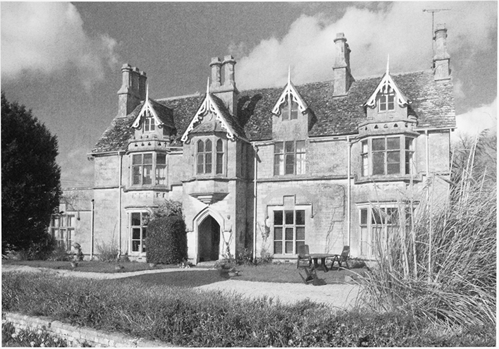
40. View of Church End, looking east with the Manor House, rebuilt by Edmund Bridges, lord Chandos, in the later 16th century, and the tower of the parish church.
The Bridges family retained some lands, concentrated in Purton Stoke (fn. 139) and the title to the manor, which passed to George Bridges, Lord Chandos (1620–1655) and then to his widow, Jane (d. 1676). In 1657 Jane married George Pitt (d. 1694) of Stratfield Saye (Hants.) and the property passed to Pitt and his descendents. (fn. 140) In 1738 George Pitt of Stratfield Saye was described as lord of the manors of Great Purton. (fn. 141) He died in 1745 and was succeeded by his son, also named George (d. 1803), who was created 1st Baron Rivers in 1776. (fn. 142) Purton Keynes and Purton Poucher farm of c. 50 a. was sold off in 1792. (fn. 143) The Purton estate descended with the manor of Minety, which was owned by one Joseph Pitt c. 1792–1844, (fn. 144) perhaps the same Joseph Pitt who owned Bury Hill farm, c. 250 a. in Purton Stoke in the same period. (fn. 145) By 1875 the Pitts were no longer lords of the Purton's manors, described at that date as the Great manor, Purton Poucher, Purton Keynes and the Little manor, which included Purton common. (fn. 146) Dr Waraker was lord of the Great manor c. 1870–80, (fn. 147) and sold it with the Hill House estate, c. 40 a. to Cornwallis Wykeham-Martin (d. 1903), from whom it passed to his son Charles Wykeham-Martin (d. c. 1911), whose trustees sold it in 1920, (fn. 148) after which the title lapsed. Edmund N. Ruck, lord of Purton Keynes manor c. 1875–80, (fn. 149) was succeeded by Thomas Glenn c. 1898, and his trustees c. 1903–1911. (fn. 150) Lordship of the Great manor, Purton Poucher, and Purton common was also claimed by the earls of Shaftsbury, (fn. 151) who sold lordship of Purton Poucher to Charles M. Beak, whose trustees sold it to Helen Walsh. (fn. 152)
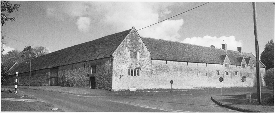
41. The two ranges of barns on the manorial site, from the south-west. The east end of the south range was converted into cottages in the 19th century.
Manor House (Church End)
Malmesbury abbey's
manorial site lay to the west of the church, where the
present manor house stands. William of Colerne (abbot
1260–96) redeveloped it, building a hall inside a
surrounding wall and a grange with a stone roof. A new
garden was laid out with two fishponds and a third
fishpond was made near the abbey mill. In the farmyard
he built another great stone-roofed grange, a thatched
cowshed next to the entrance gateway and two
dovecotes. (fn. 153) This aggrandisement may have been the
result of acquiring the site of the rectorial curia,
which presumably lay nearby, as a result of the
appropriation of 1276. (fn. 154) In 1547 the abbot's mansion
house had a parlour and buttery with an entrance
passage between them, a separate kitchen in the same
courtyard, a dovecote and farm buildings. (fn. 155) The
abbot's manor house was rebuilt by Edmund Bridges
before his death in 1573 at a cost of £1,200. (fn. 156) In 1610 it
was sold to Sir Anthony Ashley (d. 1628), (fn. 157) who
assigned it to his daughter Ann (d. 1628) on her
marriage to John Cooper (d. 1631). (fn. 158) It was one of the
homes of their son Sir Anthony Ashley Cooper, 1st earl
of Shaftesbury (d. 1683), (fn. 159) and in the early 18th century
was occupied by the scholarly Maurice Ashley
(Cowper) (d. 1726), brother of the 3rd earl of
Shaftesbury and translator of Xenophon's Cyropaedia. (fn. 160)
In the later 18th and 19th centuries the Ashley Coopers
apparently let the manor house to tenants, gentlemen
farmers, who included members of the Bathe family
and John Brown, a descendant, from c. 1851–93. (fn. 161)
In 1895 Charles Miles Beak, who had returned to Purton from Canada after making his fortune as a cattle drover and rancher, bought the manor house from the 9th earl of Shaftesbury. He lived there from 1895 until his death in 1900, giving a piece of his land to extend the churchyard. (fn. 162) After his death, in 1900 his executors retained 139 a. farmed as Church farm by James D. Beak in 1911. (fn. 163) Purton manor house was sold with 84 a. to Helen Walsh, widow of Arthur Francis Walsh, of the Hoystings, Canterbury, and her son Arthur J. Walsh, (fn. 164) who sold it c. 1952. (fn. 165) The Walsh family made extensive alterations to the interior and to the farmyard, gardens and surrounding closes. (fn. 166) The house was owned briefly by Thomas Fairfax, 13th lord Fairfax, subsequently by Mr and Mrs Garraway and Charles Arnott, partners in a veterinary practice run from the barns, and by Mr Thompson, a timber merchant, who sold it to the current owner Mr Coxen, a commodity broker, and his wife in 1984. (fn. 167)
The manor house stands north-east of the church slightly above the road on made-up ground; the garden to the north is terraced down to a boundary wall which may reflect the line of an old road; disturbed ground in the field north of that may indicate additional buildings once stood there. The south front of the house is 17thcentury, of five bays with gables over the centre and end bays, mullioned windows of three and four lights and a two-storey south porch which may be original. The end bays project to the north as wings, and in the angle of the east wing lies a stair tower. A modern west porch bears a stone inscribed 168.. The very thick north wall of the central three bays may predate the 16th century. It incorporates a newel stair with timber treads and belonged to a building with a ground level much lower than the present one. The eastern two bays of the house seem to have been built with two tall storeys, which may represent hall and great chamber of an apparently grander house; the upper room, according to the roof structure, had a plaster barrel-vault, probably of the late 16th century. In the 17th century the western end of the house was rebuilt with the present floor levels, and the eastern end reconstructed as a cross wing. In the later 19th and early 20th centuries the exterior was tidied up, and before 1887 rooms had been built on the north side between staircase tower and west wing. Two north-west service wings with courtyard between had been built before 1923. (fn. 168)
The present barns are arranged as an L west of the manor house. The two ranges, of ten and thirteen bays, were probably built in the late 16th century or the 17th century; the roofs have tenoned collar and tie trusses with queen struts and upper raking struts. Both barns were made to look picturesque in the late 19th century, probably by C. M. Beak. The changes included the insertion of modern brick into the timber framing below eaves level, the conversion of the east end of the south range into a dwelling and milking parlour with granary over, and the re-use of mullioned windows, probably from the house, to light an east staircase and fill openings broken through the south-western gable. Other outbuildings then in the farmyard may have flanked a surviving brick granary with dovecot and 1746 date. (fn. 169)
PURTON KEYNES
The estate described in 1375 as Purton Keynes manor passed from Robert de Keynes in 1281 to his son and heir, Robert, a minor, who came of age in 1289, (fn. 170) and before his death granted it to Hugh le Despenser, earl of Winchester. On Despenser's fall, it was confiscated by the Crown, but was returned to Robert's widow Eleanor as dower in 1327. (fn. 171) The estate passed to their son Robert de Keynes, (fn. 172) and by 1361 was held by John de Keynes, who died in 1366, leaving it to his son John, a minor. (fn. 173) John became a royal ward and in 1370 his property was leased to John Wecche, or Weeks. (fn. 174) In 1375 John de Keynes and his sister Gwenllian both died as minors, and the estate passed to their aunt Elizabeth, sister of John de Keynes, who apparently sold it to William of Brantingham. (fn. 175) Elizabeth died in 1385 and her heir was Margaret, widow of William of Wootton, who relinquished her claim to Brantingham. (fn. 176)
Brantingham held the manor, by then known as Purton Keynes alias Brantingham until his death in 1413. (fn. 177) The manor then reverted to Alice, wife of Lewis Cardigan, a descendent of the de Keynes family. In 1420 she granted the manors of Purton Keynes and Purton Stoke to Robert Andrew, who held them in 1428. (fn. 178) Until 1502, when he was attainted and his lands forfeited to the Crown, these manors were part of the estate of Edmund Ferrers, centred on Blunsdon. (fn. 179) In 1503 the King granted the estate to Giles Bridges (d. 1511), (fn. 180) and at the time of Malmesbury abbey's dissolution, it was held by his son, Sir John Bridges (1st Baron Chandos from 1554, d. 1559). (fn. 181)
After Sir John's death, Purton Keynes manor presumably passed to his heir Edmund Bridges, and Lord Chandos, by then lord of the abbey's demesne manor. It descended with that manor with Edmund's heirs at least until the sales of 1609.
Keynes Court
A manorial or court house had
evidently been built by the earlier 13th century, when
Thomas of Purton (d. by 1238), who had already
granted his demesne tithes to Malmesbury abbey,
received permission from Abbot John (1222–46) to
establish a private oratory within its walls, provided it
did not prejudice the rights of Purton parish church. (fn. 182)
Keynes Court or Place is mentioned in 1376 as held by
Gwenllian Keynes. (fn. 183) Described as the demesne house, it
was still in existence in 1609 when it was sold to William
Read, a yeoman. (fn. 184) Its location is unknown. (fn. 185)
PURTON PAYNEL (POUCHER)
Isabel de Welle's quarter of her father Adam of Purton's estate appears to have passed to her Paynel relatives by 1274, when it was held jointly by her brothers-in-law Robert de Keynes (d. 1281) and Sir John Paynel (d. 1275) and assessed as a ½ knight's fee. (fn. 186) It presumably descended to John and Catherine Paynel's sons, John (d. 1287) and Philip (d. 1299) and then to John Paynel (d. 1334) and was inherited by his daughter Margery (d. 1349), wife of John Pouger, from whom it passed to their son, John Pouger. (fn. 187) He died in 1405, having unsuccessfully tried to gain possession also of Gascrick manor. (fn. 188) His son John Pouger added a freehold called Nele's place to his Purton property before he died in 1418. (fn. 189) His heir was his son Henry, a minor, who died in 1421. (fn. 190) Nele's place became the property of John Pouger, who died in 1423, (fn. 191) and in 1428 another John Pouger was tenant under Malmesbury abbey. (fn. 192) The manor passed to the Sotehill family by marriage. When Sir John Sotehill died in 1495, his son George, a 'natural idiot from his birth' was heir. (fn. 193) On George's death the manor of Purton Poucher passed in 1502 to his sister Barbara, wife of Sir Marmaduke Constable (d. 1545), whose family subsequently broke up the manor. (fn. 194)
A capital messuage in Purton, held by Catherine Paynel, daughter of Adam of Purton, at her death in 1296, and rented from her nephew Robert de Keynes, was perhaps originally that of the Welle's or Paynel portion of Adam's inheritance. (fn. 195) The capital messuage and lands of Purton Poucher were sold in 1553 by his son, Robert Constable to William Telling, husbandman and Thomas Calfee, yeoman. The sale included Poucher's grove, later known as Pouchers rag, 300 a. of Braydon forest. (fn. 196) The Constables sold another portion of their estate to Sir Anthony Hungerford (d. 1558), (fn. 197) of Down Ampney (Glos.), whose kinswoman Mary Hungerford (d. 1533) was a freeholder of the manor. (fn. 198) Telling's daughter Elizabeth married John Read and through her the capital messuage, Neal's (Paynel's) farm, and certain lands passed to the Read family and became known as Read's tenement. The location of the farm and tenement are not known. (fn. 199) However, Reads tenement descended in the Read, Watts and Bathe families, with a tenement called Scissells or Richards from 1783. (fn. 200)
GASCRICK
The quarter of Adam of Purton's estate inherited by Catherine and Sir John Paynel in c. 1266 passed in turn, after Sir John's death in 1275, to their sons John (d. 1287) and Philip (d. 1299). (fn. 201) It passed to another John Paynel, and on his death in 1334 to his daughter, Elizabeth, wife of Richard le Gascrik. (fn. 202) Elizabeth and Richard sold part of the estate, 106 a. in Braydon forest, to John de Barton and John de Melton, who sold it to Henry, earl of Lancaster and Derby in 1342. (fn. 203) Elizabeth subsequently married Thomas of Fulnetby. After she died in 1373, William of Gascrick successfully sued John of Fulnetby for reversion of her quarter of Purton manor. (fn. 204) Gascrick manor was leased to Nicholas Wotton, and Edmund Gascrick sold it to him and Edmund Dauntsey in 1422. (fn. 205) Still held by Nicholas Wotton in the 1430s, (fn. 206) by 1514 it was re-united with the manor of Purton Poucher under the ownership of Sir Marmaduke Constable. Gascrick manor reverted to the Crown in 1539 and seems to have become the property of the duchy of Lancaster. (fn. 207) In the later 16th and early 17th centuries the Hungerford family claimed lordship of Purton Wootton, (fn. 208) as did Anthony Ashley in 1617, when the manor was among the holdings he assigned to his daughter and her husband John Cooper. (fn. 209)
OTHER ESTATES OF MEDIEVAL ORIGIN
Pavenhill
The estate, which was based in the south of the parish and which by the later 15th century had become the reputed manor of Pavenhill, may have originated in a mill and three hides in Purton held by Walerand of Blunsdon before 1241. (fn. 210) In the later 13th century other members of the Walerand family held land in the parish. In 1275 Nicholas Walerand encroached on the highway at Restrop and Hoggs Lane, and in 1276 John Walerand had a house at Pavenhill. (fn. 211) By 1281 Waleran's sons, Nicholas and John had both inherited lands in Purton from their father. (fn. 212) In 1332 William Walerand, parson of Leigh, had a house and a ½ virgate of land in Purton, (fn. 213) and Adam Walerand, who held an estate centred on Broad Blunsdon, was one of Purton's wealthier residents. (fn. 214) Two hides of land at Pavenhill were part of an estate held by Thomas Walerand in 1348, (fn. 215) and later by William Walerand, who died in 1369. William's heir was his nephew Gilbert of Shotesbroke, son of his sister Joan. (fn. 216) In 1428 John de Shotesbroke owed ½ knight's fee for Purton lands, as tenant of the Abbey. (fn. 217) Thomas Rogers held the manor from Malmesbury abbey in 1488, when it descended to his daughter Elizabeth and her husband William Essex. (fn. 218) They remained in possession when the abbey was dissolved. In 1550 it passed to their son Thomas, who leased it to Vincent Godard and his wife Elizabeth in 1557, (fn. 219) and then sold it to John Sadler in 1583, when it was said to include Malfords. (fn. 220) Thomas Sadler sold some of the lands to William Holcroft (d. 1632), and some to William Read in 1616. (fn. 221)
Malreward (Malfords)
In 1242 Robert Malreward owed military service of 1/8 knight's fee. (fn. 222) Thomas Malreward held 1½ hides of land in Purton in the 1290s, (fn. 223) which passed to Robert Malreward by 1332, (fn. 224) and was held by the heirs of John Malreward in 1428. (fn. 225) The estate may have become part of the Walerand family's estate at Pavenhill, which John Sadler purchased in 1583. (fn. 226)
Restrop
Denise of Radestrop was a free tenant in 1323, and her son Thomas in 1353 was granted licence to hold the estate for his life and that of his son. (fn. 227) This holding may have become the Restrop estate in the south of the parish which belonged to John Diggs (or Dix) in 1576. (fn. 228) By 1588 it had passed to his son Edmund Diggs and his wife Elizabeth, the sister of Lionel Cranfield (earl of Middlesex from 1622), who still held the estate in 1609. (fn. 229) The estate passed from Edmund Diggs, owner in 1609, to his brother Giles. He sold it to his nephew William (d. 1640), who bought lands from Richard Diggs and others to add to the estate, which passed to his son Richard. (fn. 230) In 1719 Anne, widow of Toby Richmond was tenant of the estate, which consisted of c. 300 a., (fn. 231) owned by Richard Diggs in 1738. (fn. 232) In 1744 the estate was occupied by Dr Frampton. (fn. 233) Richard Francome (1736–1797), who came to Purton c. 1760, may have had an interest in the estate, as might his sons John Francome (1767–1814) of Restrop farm and Richard Francome of Constables farm. (fn. 234) When added to the Shaftesbury estate it was known as Framptons, and the mansion with c. 200 a. was let to tenant farmers. (fn. 235) The estate and mansion were sold by Lord Shaftesbury some time after 1892. (fn. 236)
Restrop House
Built c. 1600, probably by Edmund
Diggs (fl. 1588–1609) on the site of an earlier house, (fn. 237) in
1641 it was described as a mansion house called
Restrops Place. (fn. 238) The main block is E plan, of limestone
rubble, with two storeys, an attic floor, a part cellar, and
mullioned and transomed windows. Wings project at
the rear: a north-eastern wing, containing a fine dog-leg
staircase, was extended during 17th or 18th century by a
two-storey service block, and a north-western wing was
added c. 1912, when the central chimney was probably
removed. (fn. 239) Over the porch entrance are carved the arms
of the earls of Shaftesbury of the mid 18th century. The
house was known then as Frampton's Great House, (fn. 240)
and it may have been about that time that the hipped
stone slate roof was added to modify an originally
gabled facade. It was subsequently occupied by two
families of gentlemen farmers, the Large family from
1789, (fn. 241) and c. 1813–92, the Warman family. (fn. 242) In 1912
Restrop House was bought by Lieut. Col. Canning
(d. 1960), who extended and restored it. (fn. 243) Main rooms
have moulded stone fireplaces, one with a carved
wooden overmantel.
42. Restrop House, probably built by Edmund Diggs c. 1600, altered in the 18th century, and depicted before being restored and extended in 1912 by Lieut. Col. Canning.
Rectory Estate
Malmesbury abbey took over direct management of the rectory estate when it appropriated it in 1276. (fn. 244) The location of the rector's curia or manorial site is unknown, but it was presumably near the church and hence after 1276 it may have been absorbed into the abbey's manorial site which also lay nearby. The rectory estate was leased together with the abbey's demesne manor in 1515. (fn. 245) At the dissolution it was acquired, with the demesne manor, by Edmund Bridges (d. 1573), and descended with the Bridges' Purton Keynes estate. (fn. 246) In 1609–10 it was sold, with the advowson of Malmesbury church, to Anthony Ashley (d. 1628), and descended with the Shaftesbury estate. (fn. 247) The income from the rectory, or parsonage, and the tithes was £150 2s. in 1729 and had risen to £239 13s. 10½d. in 1771. (fn. 248)
Bentham
A freehold estate, dependent by 1249 on the keeper of Braydon forest's manor of Chelworth (in Cricklade), (fn. 249) Bentham included two moated, and therefore highstatus, sites, also Temple close, a valuable pasture adjoining Braydon forest. (fn. 250) Presumably it was retained by the Keynes family, after the sale of the keepership and its Chelworth manor to the Despensers in 1300, and descended with Purton Keynes manor to be sold by Gray Bridges after 1609. (fn. 251) By 1640 a farmhouse called Benthams belonged to Thomas Shayle. (fn. 252) At some point it was acquired by the Cooper family, earls of Shaftesbury, and descended to Cropley Ashley Cooper, (d. 1851), who sold it to Samuel Sadler (1782–1845) in 1825. (fn. 253) It descended thereafter with the Sadler estate until this was dispersed by sales c. 1950. (fn. 254)
Bentham Farmhouse
Situated in Purton Stoke, it
was built on a raised site in the mid 18th century or
earlier. (fn. 255) The barn and stable complex with attached
pigsties date from the time of the 1825 sale. (fn. 256) In the mid
19th century, the farmhouse was rebuilt with some
pretension as Bentham House by the Sadler family, but
it retains elements dating back to c. 1750. (fn. 257)
Pond Farm
A high-status medieval moated site, (fn. 258) it was the centre of an estate held by the Bathe family from c. 1640, (fn. 259) until the mid 18th century. (fn. 260) It was inherited from his brother Richard by William Bathe (vicar 1664–1715), and passed to his son William Bathe, who left it to his great nephew, William Maskelyne (d. 1772). The house was the country retreat of Revd Dr Nevil Maskelyne (1732–1811, Astronomer Royal from 1765). (fn. 261) After his death the furniture was taken to his family's main seat at Bassett Down. (fn. 262) Thereafter Pond Farm was occupied by tenant farmers. The house and farm descended with the Maskelyne (Purton Down) estate until its sale in 1928. (fn. 263)
43. Pond Farm on a medieval moated site. The taller part is late 16th century, the gabled section of c. 1600.
Pond Farmhouse
A much altered house of irregular
plan stands within the moat. Built of limestone rubble,
the southern end of the main range has two full storeys
and a steep stone-tiled roof with coped parapet to the
north gable end. The east front facing the road has on
the ground floor mullioned and transomed windows
under relieving arches, which together with internal
details suggest a building erected during the late 16th
century. The lower northern end of the house was built
c. 1600 and has two gabled bays and one surviving
mullioned window. The house was remodelled with
sash windows inserted c. 1800, but major alterations
ceased after Maskelyne's death in 1811. An early 18thcentury rubblestone stable with half-hipped stone slate
roof adjoins the house at right angles. To the north is a
cowshed built of coursed squared stone c. 1903 in Arts
and Crafts style. (fn. 264)
Other high status freehold sites
Nicholas de Baddebyr, a knight, held a 2-virgate freehold estate in 1250, perhaps at Bagbury. (fn. 265)
The moated site at Widham, occupied in the later Middle Ages, (fn. 266) suggests premises of high status. Widham farm, built in c. 1600, (fn. 267) was a possession of the earls of Shaftesbury in the 19th century.
ESTATES OF LATER ORIGIN
With the fragmentation of the medieval manors a number of new landowning families emerged, including some drawn from established tenants, who by purchases in 1609 and subsequently accumulated freehold estates in Purton.
Hungerford estate
In the 16th and 17th centuries the Hungerford family held lands centred on Purton Stoke, as part of wider property interests in the area. (fn. 268) Anthony Hungerford (d. 1558), of Down Ampney (Glos.), (fn. 269) acquired various lands in Purton. (fn. 270) A freehold in the manor of Purton Poucher passed with the manor of Chelworth Poucher, Cricklade from his kinswoman Mary Hungerford (d. 1533). (fn. 271) In 1554 he purchased 300 a. in Purton Poucher, (fn. 272) and leased Temple close, Bentham, from the duchy of Lancaster. (fn. 273) Lordship of the manors of Purton and Purton Stoke passed to his son John (d. 1582), (fn. 274) and a claim to the lordship of Purton Wootton manor. (fn. 275) The property apparently passed with Chelworth Poucher down the Down Ampney Hungerford line. (fn. 276) Temple close was subsequently held by John Ernley who sold it to Anthony Hungerford (d. 1627), of Black Bourton (Oxon.). (fn. 277) It was still owned by one Mr Hungerford in c. 1650. (fn. 278)
Shaftesbury estate
A major purchaser in 1609 was Anthony Ashley (d. 1628) of Wimborne St Giles (Dorset), who from 1596 had owned land in Purton which formed part of an estate in Lydiard Millicent. (fn. 279) He acquired from Lord Chandos the Rectory estate and property belonging to the manors of Purton and Purton Keynes. (fn. 280) In 1617 Ashley assigned certain lands to his daughter Ann (d. 1628) on her marriage to John Cooper (d. 1631). These included Purton manor house and parts of Purton Great Manor and Purton Wootton (Poucher). (fn. 281) This estate passed to their son Sir Anthony Ashley Cooper (Baron Ashley from 1661, 1st earl of Shaftesbury from 1672, d. 1693), (fn. 282) and descended with the title earl of Shaftesbury in the direct line through four generations, all named Anthony Ashley Cooper (d. 1699, 1713, 1771, 1811), and then to a brother, Cropley Ashley Cooper, 6th earl of Shaftesbury (d. 1851). (fn. 283)
Some time before 1759 parcels of land belonging to Anthony Wheelock were added to the estate, and around the same time Restrop was acquired. By 1800 the Shaftesbury property had reached its greatest extent of over 1,250 a. (fn. 284) In 1824–5 the 6th earl sold around half the estate, including Wells farm, Bentham farm, Common farm, Flaxmore, or Haxmore, farm, and Sparcells farm, part of which lay in Purton and part in Lydiard Millicent. (fn. 285) The reduced estate, which included Manor farm, Restrop farm and Widham farm, descended with the title to Anthony Ashley Cooper, 9th earl of Shaftesbury, who offered the remaining 620 a. for sale in 1892, much of it divided into small building plots. (fn. 286)
Hyde estate
In 1609 Nicholas Hyde had an interest in another portion of Purton manor, presumably acquired from Lord Chandos. (fn. 287) His brother Henry Hyde (d. 1634) bought an estate at Purton and moved his family there from Dinton c. 1623–5. (fn. 288) Henry's son, Edward Hyde (1609–1674, earl of Clarendon from 1661) recuperated from serious illness at Purton in 1625–6; (fn. 289) although it has been suggested that Edward's daughter Anne (1637–71), future wife of James II, may have been born there, she was probably born in Windsor (Berks.). (fn. 290) On account of Hyde's Royalist allegiance, the estate was heavily taxed by Parliament in 1646, (fn. 291) but remained the property of the Hyde family in 1665. (fn. 292) The Hydes sold the estate to Sir Charles Duncombe in 1708, and it was ultimately purchased by George Clarke in 1718. (fn. 293)
In 1739 George Clarke, fellow of All Souls College, Oxford, became Worcester College's major benefactor, when he bequeathed his estate, which included College and Pavenhill farms, to endow six fellowships and three scholarships. (fn. 294) College farm was sold to the tenant farmer, Charles John Iles (d. 1945), in 1906, although the College retained the house until 1964. (fn. 295) Iles bought Pavenhill farm in c. 1912. (fn. 296)
College Farmhouse
The Purton premises of the
Hyde and Clarke families was bequeathed to Worcester
College, Oxford, in 1739. An early 17th-century arched
gateway contemporary with the house was the original
approach from High Street. The two-storey house with
pitched roof and end chimneystacks is L plan, with a
symmetrical east front of five bays, and a central gabled
porch, on which the date 1754 is scratched; the two-light
mullioned windows with hoodmoulds have been
modified and the attic dormers added. The central
entrance lobby, with stairs to the rear, is flanked by
reception rooms. (fn. 297) In the early 17th century the parlour
was fully panelled, and the stone fireplace, possibly
later, has an elaborate wooden overmantel dated 1626,
carved with the coat of arms of Amy Sibell (d. 1606), the
mother of Henry Hyde (d. 1634). (fn. 298) A similar overmantel
on the first floor has different arms. Attached to the
north end of the house is another dwelling of 1½ storeys,
built in the late 16th or early 17th century and later used
as an outbuilding; it retains a large stone fireplace in the
central bay of three. A brick granary in the farmyard
was built in 1759. (fn. 299) The college retained possession of the
house after the land was sold off in 1906 to its tenant,
Charles Iles, who undertook repairs and modernization;
it was further restored by subsequent owners. (fn. 300)
Maskelyne (Chamberlains) Estate
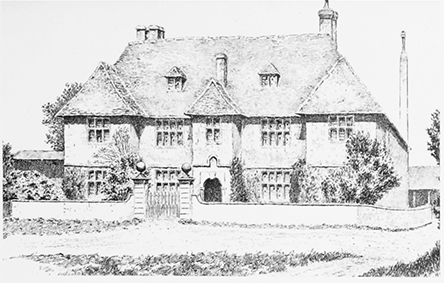
Members of the Maskelyne family held land in and around Purton in the later 1400s, (fn. 301) and in 1576 Robert Maskelyne (fl. 1551–76), was one of Purton's wealthier inhabitants. (fn. 302) His son Henry (d. 1640), greatly enlarged the estate when he bought Purton manor lands from Lord Chandos in 1609. These included Chamberlains, Ayleford mill, and lands at Westmarsh. Chamberlains, which lay in Church End, was presumably a substantial house or estate in the Middle Ages since, as its name implies, its rent supported the abbey's chamberlain. Presumably it had been acquired by Bridges together with the main manorial site in 1544. The enlarged estate passed to Henry's son William (d. 1649), and to his son Henry, who died without heirs in 1667. Chamberlains and other lands were sold to Francis Goddard in 1669. (fn. 303)
Francis Goddard (d. 1701), was succeeded by his sons Edward (d. 1710), and Anthony (d. 1725), and his grandson Richard Goddard MD (d. 1776). (fn. 304) In 1792 Richard Goddard's only daughter Margaret (d. 1843), married Capt Robert Wilsonn RN (d. 1819), and had four daughters. (fn. 305) Capt Wilsonn's estate included Ridgeway farm, 193 a. and land in neighbouring parishes. (fn. 306) In 1824 Sarah, his eldest daughter, married Richard Miles (d. 1839), who purchased Purton House from his wife's family in 1829. (fn. 307) In 1840 Sarah Miles sold Purton House with grounds of 30 a. and other lands to a cousin, Horatio Nelson Goddard. In 1843, after Margaret Wilsonn's death, her daughters Isabella and Emma sold their portion of the estate, Ridgeway farm, a mill and a stone quarry, (fn. 308) and Horatio Nelson Goddard sold his portion and Purton House and grounds, to Major Elton Mervyn Prower, the son of John Mervyn Prower (d. 1869), vicar of Purton. (fn. 309) 1878 the Prower family sold the estate to Sir Charles Brooke, 2nd Rajah of Sarawak. (fn. 310) He let the house to the Russell family, who bought the estate in 1899 and sold it to Capt. Arthur Percy Richardson c. 1908. (fn. 311) In 1931 it was bought by William Wilson Fitzgerald, and passed to Col. Francis Wilson Fitzgerald in 1935, and to his son, Lieut. Col. William Wilson Fitzgerald, who sold the estate in lots in 1976, (fn. 312) when Purton House and 38 a. was bought by Mr and Mrs Barker. (fn. 313)
Chamberlains (Purton House)
The Maskelyne
property, sold to Francis Goddard in 1669, was called
Chamberlains in the 16th and 17th centuries and
Church End house by 1800. (fn. 314) Richard Goddard (d.
1776) modernised the house, laid out the grounds and
made an ornamental lake from the medieval
fishponds. (fn. 315) A contemporary drawing of the house
survives from around this time. (fn. 316) In the early 1800s,
Robert Wilsonn (d. 1819) undertook substantial
building work on the house, (fn. 317) after which it had four
reception rooms, four main bedrooms and a sitting
room, six servants' bedrooms, servants' quarters, a
service wing, cellar and gardener's room. (fn. 318) Between 1829
and 1839 Richard Miles replaced that house with the
present symmetrical three-bay house, faced with finely
dressed ashlar, and created new offices, coach houses
and stables. A new western entrance façade was made,
and a central porch, with ionic columns in antis,
superseded the previous eastern entrance. Parts of the
previous building were incorporated into the internal
structure. (fn. 319) By 1839 when the property was again to let,
it was known as Purton House. (fn. 320) Major Prower added a
servants' wing with offices below in 1863. (fn. 321)
Maskelyne (Purton Down) Estate
A second branch of the Maskelyne family also held land in Purton. (fn. 322) In 1576 George Maskelyne (d. 1582), younger brother of Robert Maskelyne (fl. 1551–76), owned a small estate at Purton Down. (fn. 323) His son Edmund (d. 1630) greatly enlarged the estate by buying lands at Westmarsh from the Dodeswell family in 1598; Malfords and other Purton manor lands from Lord Chandos in 1609; (fn. 324) and an estate at Bentham from the Ware family in c. 1613. (fn. 325) Edmund's son Nevil (d. 1679), (fn. 326) inherited the estate and passed it to his grandson Nevil (d. 1711), of Westmarsh, Purton. (fn. 327) His son Nevil (d. 1774), sold the property at Westmarsh and rebuilt Down farmhouse at Purton Down for himself. (fn. 328) Nevil's brother Edmund had three sons and a daughter, Margaret, afterwards Lady Clive. (fn. 329) Edmund's eldest son William (d. 1772), inherited Pond farm, Purton Stoke, from his great-uncle, William Bathe. (fn. 330) In 1763 Edmund's second son, also Edmund (d. 1775), bought an estate at Bassett Down in Lydiard Tregoze, now Wroughton parish, which became the family's main residence. (fn. 331) The third son Revd Dr Nevil Maskelyne (d. 1811) outlived his brothers to inherit the estates at Bassett Down and Purton, which included Pond Farm, his country residence. (fn. 332) The estate passed to his daughter, Margaret (d. 1858), and her husband Anthony Story, who took the name Story-Maskelyne, then to their son Mervyn Story-Maskelyne (d. 1911), and to his daughter Mary and her husband Hugh Arnold-Forster. (fn. 333) Mervyn Story-Maskelyne added more property to the estate, including Restrop farm in 1876. (fn. 334) Mary Arnold-Forster offered the Purton estate for sale in 1928, when it covered 608 a. and included Restrop farm, Pond farm, Down farm and Brockhurst wood. (fn. 335)
Sadler Estate
The Sadler family were wealthy yeomen and the tenants of a former estate of Tewkesbury abbey (Glos.), which included lands in Purton in 1555. (fn. 336) In 1583 John Sadler bought the reputed manor of Pavenhill from Thomas Essex, (fn. 337) and Thomas Sadler sold some of the lands to William Holcroft (d. 1632), and William Read. (fn. 338) Some family members made money in international trade, (fn. 339) and the family either owned or leased significant amounts of land in the parish. (fn. 340) In 1799 James Sadler was among the wealthier farmers in the parish, (fn. 341) and in 1815 John Sadler had an estate of c. 140 a. in Purton Stoke. (fn. 342) Samuel Sadler (d. 1845) of the Court, now Purton Court, became one of the largest landowners in the parish when he bought part of the Shaftesbury estate in 1825, which included Bentham farm. (fn. 343) By 1838 he owned an estate of 193 a. based on Bentham House; he also owned Wells farm, Purton Stoke, another 50 a.; and farms in the east of the parish, Haxmore farm, 100a. and Pry farm, 104 a. (fn. 344)
Bentham farm, with Bentham House, passed to his eldest son William James Sadler (1804–70), (fn. 345) and then to William's daughter Caroline, (fn. 346) wife of Col. Thomas Heycock. (fn. 347) Other parts of Samuel's estate passed to his younger son, Dr Samuel C. Sadler. His son, James Henry Sadler (1843–1929), of Lydiard House, Lydiard Millicent, known as the 'squire of Purton', added to the estate in 1892 when the rest of the Shaftesbury estate was sold. (fn. 348) When the Maskelyne estate was sold in 1928 he purchased Pond farm, Purton Stoke, 157 a. (fn. 349) Among the other farms he owned in 1910 were New farm, Bentham, 59 a.; and Mill farm, 73 a.; (fn. 350) and in 1941 Fox Mill farm, and Bagbury Green farm, 53a., (fn. 351) also Hayes Knoll farm, and lands in Lydiard Millicent. In c. 1950 all his properties were offered for sale to the sitting tenants, before they were sold on the open market. (fn. 352)
Other members of the Sadler family owned land in Purton. Thomas Sadler bought Blakehill farm in 1826, 143 a. on the northern arm of the parish, (fn. 353) and following his death, it was sold in 1871. (fn. 354) Ann Sadler owned Ridgeway farm, Church End. (fn. 355)
Purton Court
The handsome house at 3 High
Street was built in the mid 18th century perhaps to
replace an earlier house. Because the site slopes down
from the street, there are two storeys at the front and
three at the rear. The main five-bay south front is
terminated by ashlar pilasters, has windows with raised
ashlar architraves and keystones, and a Tuscan porch. A
rear block was added in the early 19th century, and the
west, garden front was remodelled. (fn. 356) 'The Court' was
the home of Dr Samuel C. Sadler (d. 1889) and his son
James Henry Sadler (1843–1929), who owned large
portions of the parish. From c. 1890 it was let to tenants
and sold after James Sadler died. In the 20th century it
had several owners and after falling into decay it was
renovated in the early 21st century. (fn. 357)
Bentham House
Bentham farmhouse was rebuilt
for the wealthy Sadler family c. 1850–2 in 'vigorous early
Victorian gothic style', with ashlar facing, a display of
bay windows and gables with carved barge boards, and
internal fittings in the same style. (fn. 358) A single-storey
carriage house of limestone rubble dates from the same
period. Service wings at the rear preserve several earlier
phases of building dating back to c. 1750. (fn. 359) Additions
were made in 1867 by a Swindon architect, Thomas
Smith Lansdown, (fn. 360) and a billiard room was added in
1903. (fn. 361) Bentham House and 25 a. descended to Caroline
Sadler and her husband Col. Thomas Heycock (d.
1931), (fn. 362) and was used after 1939 as a centre for evacuees.
In the 1950s the land was sold to the tenant farmer,
Leonard Scott, and the house became a preparatory
school for boys. (fn. 363) Later uses have included dog
breeding, (fn. 364) and as a centre providing music therapy to
handicapped adults. (fn. 365)
Bathe Estate
By the later 16th century the Bathes were a wealthy yeoman family, (fn. 366) tenants of Purton Keynes manor, where Richard was succeeded by his son William (d. 1610). (fn. 367) Another son, Anthony, was a tenant of Malfords at Pavenhill. (fn. 368) The family also held the Pond farm estate from c. 1640, (fn. 369) until the mid 18th century. (fn. 370) Inherited by William Bathe (vicar 1664–1715), it passed to his son William Bathe. By then, this William could be described as a gentleman, (fn. 371) and was one of Purton's wealthiest residents in 1738. (fn. 372) Anthony Bathe (d. 1769), yeoman, left a substantial landed estate to his sons William, John, James and Anthony and a malthouse to Richard; his children also received a legacy in 1777 from their maternal grandfather Richard Garlick of Wroughton. (fn. 373) John and Anthony Bathe were among Purton's wealthiest residents in 1799. (fn. 374)
The family began to build up a freehold estate, centred on High Street, in the early 19th century, when in 1823 Richard Garlick Bathe and William Bathe purchased a capital messuage called Read's tenement, originally part of Purton Poucher manor, and a tenement called Scissells or Richards from Richard Read. (fn. 375) In 1838 Richard Garlick Bathe farmed Purton Manor farm, 356 a., and the vicar's glebe, 46 a., and he owned Spring Grove farm, 159 a. west of College farm, (fn. 376) and in 1840 a large house called Hallidays, occupied by the Misses Bathe. (fn. 377)
The Bathe family estate passed to the Brown family through Richard Garlick Bathe's daughter Sarah, wife of John Brown. (fn. 378) By 1910 the Brown estate included Blacklands farm, 135 a. (fn. 379) It also included the hospital and other properties in Purton village purchased by William Brown, and Blake Hill farm, 139 a. purchased by John Brown (d. 1920). After John Brown's death his executors sold off the estate piecemeal. (fn. 380)
ECONOMIC HISTORY
Agriculture was the main occupation of Purton's inhabitants until the 19th century. Arable crops were cultivated on pockets of stonebrash soil and in other parts of the parish in the Middle Ages. Extensive pasture and meadow on the heavy clays supported livestock and dairy farming. Cattle and sheep were being reared for the London market by the early 1600s. (fn. 381) After the coming of the railway in the mid 19th century, many small dairy farms grew up to supply liquid milk for doorstep delivery in London and Birmingham. In the later 19th century Swindon railway works offered employment to Purton's inhabitants, and in the later 19th and 20th centuries small industries developed within the parish.
AGRICULTURE
Before inclosure
In 796 there were 35 manentes of cultivated land at Purton, corresponding to 35 hides recorded in 1066. In 1086 there was enough land for 24 plough teams. Malmesbury abbey had two plough teams and five slaves to work its demesne lands of 21½ hides. A further 20 households of villeins, 12 of bordars and 13 of cottars had 19 plough teams between them. (fn. 382)
Little is known of the abbey estate's administration, but in 1275 Geoffrey of Purton served as reeve. (fn. 383) The annual income of the demesne manor was valued at £18 in 1291 and the manorial site and the demesne were farmed out at for £23 p.a. in 1515. In the 1530s, the total annual value of the abbey's estate, including customary rents and the farm was put at over £52 and in 1541 when it was in the king's hands it was valued at over £60. (fn. 384) In 1547 mixed farming was practiced on the demesne farm; corn was grown, cattle, goats and poultry were reared and the farm buildings included a dove house, a wool store and a malt loft. (fn. 385) Some tenants may have farmed their holdings from premises near the church and along the High street. Farmsteads belonging to free tenants lay to the south at Restrop (fn. 386) and Bagbury, (fn. 387) and probably to the north at Down farm. (fn. 388)
Arable
The stonebrash soils of the Corallian
ridge were suitable for arable cultivation and this is
probably where the manorial demesne and most
medieval farmsteads lay. (fn. 389) In the late 13th century, 61 a.
of arable land was cultivated as part of the lord's
demesne of Purton Keynes manor, (fn. 390) and Purton Paynel
manor had 64 a. of demesne arable. (fn. 391) In 1349, Purton
Paynel had 40 a. of demesne arable, (fn. 392) which had shrunk
to 23 a. by 1405. (fn. 393) The size of the abbey's own demesne
arable is unknown, but the valuations suggest it was
considerable, perhaps 200 acres or more.
Open field arable cultivation was practised extensively on the ridge, and some furlongs remained unenclosed long enough to be mapped in the 18th century. The furlongs of Purton village may have been grouped into three open fields. Extending eastward from the church to the meadowland along the parish boundary and northward to Collins Lane was Berkfield or Barfield, which included Water furlong and the Hyde, Puck Pit corner and Steeple acre. (fn. 394) North of Collins Lane and extending to Packhorse Lane and Cricklade Road was Down field or Claredown field, including Haxmore and Hurstead furlongs. (fn. 395) West of the church and south of the High Street was Spersholte or Sparswell field, which may have included Church field and Blackford field. (fn. 396)
Restrop had its own fields, (fn. 397) including Coombe field, which lay between Ringsbury camp and the Lydiard Millicent boundary. (fn. 398) Battle field, called Beccewelle in c. 1250, (fn. 399) lay north of Ringsbury and extended to Dogridge; it was apparently farmed by tenants of Restrop and Pavenhill. Purton Stoke, despite its location on the clay soils, had its own common fields, recorded in 1553: Stoke field lay to the south of the village, and north east lay Mead furlong, Pone hill, Bean hill, Marsh furlong, Old Lands, and East field. (fn. 400)
Pasture
The parish has extensive pasture land.
The heavy clay soils which underlie all but the southeast provide rich pastures. In 1292 Blacklands, south of
the High street, was pasture for the abbey's stock; (fn. 401) and
Windmill hill, which was part of the Abbey's demesne,
was pasture in 1547. (fn. 402) The Pry (fn. 403) and Haximore (fn. 404) were two
large pastures extending along the eastern side of the
parish. (fn. 405) There was grazing on Purton common and
Purton Stoke common on the two arms of land which
reached out south and north respectively of Braydon
forest, and tenants of the manor had grazing rights in
the forest and its purlieus. Before inclosure livestock
could roam at will over large areas of common and
woodland. (fn. 406) Momes leaze was a large pasture at the
western end of Purton common, (fn. 407) adjoining Somerford
common. (fn. 408) In 1738 the freeholders held between them
625 beasts' leazes, the right to graze stock, on the areas
which were inclosed in that year. (fn. 409)
Purton Stoke grew up on the rich pastures surrounding a number of stock farms. Bentham, Pond farm and the western end of Purton Stoke village are arranged on an arc of slightly higher land around the edge of Purton Stoke common. The Key was the boundary between the common and the fields and closes west of the village.
Meadow
Domesday Book records 60 a. of
meadow in Purton in 1086. (fn. 410) The parish had extensive
meadowland lying mainly along the Ray in the east, and
along the Key and tributary streams further west, both
of which were liable to flood. In addition parts of
Purton common and much of the land around
Bentham and Pond farm was meadow. In the 13th
century the abbey leased out areas of demesne pasture
at Supestude within the ditches surrounding Heyham,
and beyond the ditches at Bekelthorne and a small
meadow called Little Heyham. (fn. 411) Other meadows used
in the Middle Ages were Little mead, Smiths mead, (fn. 412)
Cull mead, (fn. 413) Dole mead, and West mead. (fn. 414) Other
named meadows are recorded in 16th-century glebe
terriers, a 1733 perambulation and a map of 1744. (fn. 415)
Freewarren
In 1328 the King granted Malmesbury
abbey freewarren in all their demesne lands of Purton
and Braydon. (fn. 416)
Farms and Farming before Inclosure
Many tenants
may have leased farms and smallholdings for money
rents. (fn. 417) That labour services had also been rendered is
implicit in the name Monday lands, applied in the early
16th century to some tenements. (fn. 418) In the early 15th
century parcels of the demesne of Purton Keynes
manor was let to tenants, (fn. 419) and prosperous tenants
engrossed their property by renting more than one
holding. (fn. 420) Agricultural improvement through drainage
and other forms of husbandry was suggested to a
prospective purchaser in 1609. (fn. 421) At this period 149
holdings of various sizes in the parish are recorded,
sharing 583 beasts' leazes and 29 yearling leazes. The
largest farms had 24 leazes and the smallest, one, each
allowing grazing for a small number of animals. (fn. 422)
Inclosure and its aftermath
By the 1730s much of the land surrounding the villages of Purton and Purton Stoke had already been inclosed piecemeal. (fn. 423) From 1593 to 1597 landlords and tenants of Purton's manors consolidated their holdings through an exchange of lands. (fn. 424) In 1609 Malfords and Hursteed copyholds had been 'lately inclosed', (fn. 425) and in 1715 some of the land in the common fields which Maurice Ashley exchanged with Thomas Hardyman of Bagbury was inclosed. (fn. 426) The largest inclosures made by the 1730s were Manor farm on Purton common, and Bury Hill and Blakehill farms on Purton Stoke common, which belonged to George Pitt, lord of the manor. (fn. 427)
In 1733 Momes leaze c. 260 a. was inclosed and divided between 12 landowners by act of parliament. (fn. 428) In 1738 c. 1,000 a. of common pasture in the manors of Purton, Purton Keynes and Purton Poucher was inclosed by a further act to allow soil improvement to avoid disputes over stocking levels. The lands involved were Purton common, which extended west along the southern arm of the parish; in the main body of the parish Shooters Hill, Peaven Hill, Bagbury Green, Little Marsh, Widham and Cow Street; and Purton Stoke Common which extended west along the northern arm of the parish. There were 53 beneficiaries and the largest allotments went to the earl of Shaftesbury, awarded 160 a. and Nevil Maskelyne, awarded 138 a. (fn. 429) In 1799 a third act inclosed all remaining common arable and meadow lands, a total of 344 a. (fn. 430) Of the 33 allotments, the two largest were 118 a. to the earl of Shaftesbury, and 53 a. to Worcester College, Oxford.
Farms and Farming after Inclosure
The 18th-century inclosures encouraged the creation of large farms. Momes Leaze farm developed after the 1733 inclosure, and in 1838 was 171 a. of pasture belonging to the earl of Suffolk. The Pitt family as lords of the manor had already inclosed Braydon manor farm from Purton common and Bury Hill farm from Purton Stoke common by 1738, and Purton Stoke manor farm was probably also part of their estate; in 1838 the Pitts still owned Bury Hill farm, then 247 a. but Braydon manor farm, 281 a. had been sold to William Warman. (fn. 431) The chief farms of the Shaftesbury estate in 1811 were Purton farm, 388 a. farmed by the Bathe family from the manor house by the church, Restrop farm, 208 a., Bentham farm, 154 a., and Common farm, 136 a. (fn. 432) Seven other farms in the parish each held more than 100 a.
In general the older farms had most of the arable land in 1838 and farms on newly inclosed land were mainly pasture. (fn. 433) In 1879 only 20% of the parish was sown with arable crops, 75% was pasture or meadow and the rest woodland. (fn. 434) In the late 19th and early 20th centuries there were many small-holdings geared to small-scale labour-intensive agriculture, where one or two pigs and a few dairy cattle produced foodstuffs for local consumption. (fn. 435) The pattern remained the same in 1941–2, (fn. 436) and during the Second World War evacuees and other children played an important role in farm life. (fn. 437) Some farms specialised, for example Diana Lodge, where the Scott family trained race-horses. (fn. 438) The number of farms declined in the second half of the 20th century to 16 working farms in 1999. (fn. 439)
WOODLAND
The history of Purton's woodland is complicated by the fact that the western half of the parish originally lay within the bounds of Braydon forest. Domesday Book mentions woodland 2 leagues broad and 2 leagues wide. (fn. 440) The office of keeper of Braydon forest was inherited with the lordship of Chelworth manor (in Cricklade) and held by Adam of Purton (d. 1266) and his successors, also lords of Purton Keynes manor. (fn. 441) As lords of Purton manor, they controlled customary rights to pannage for pigs and windfall wood, for which their tenants made regular payments, worth 2s. in c. 1281. (fn. 442) Over the centuries the area of forest over which the Crown claimed exclusive rights diminished and came to be surrounded by purlieus, areas where the manorial lords and tenants of surrounding parishes had grazing rights. The two arms of Purton which intruded into Cricklade parish were apparently purlieus: Poucher's rag formed the northern half of Purton's northern arm and Keynes rag the southern half, each belonging to sub-divisions of Purton manor; (fn. 443) Purton's southern arm was composed of the purlieu of Momes leaze, (fn. 444) a purlieu belonging to Purton Keynes manor. (fn. 445) In 1418 the manor of Purton Poucher included a wood of 180 a., (fn. 446) and in 1553 its woods were named Pouchers rag, Succondes and The Crockers. (fn. 447) In the early 16th century the woodwards of Purton Poucher manor were presenting tenants who were clearing woodland and carting away undergrowth, including John Hungerford, a free tenant of the manor, for cutting down two oak trees to build his house. (fn. 448) The tenants had pasture rights in Poucher's rag, which covered 300 a. in 1665, when they resisted Sir John Hungerford's attempt to claim it as his. (fn. 449)
In 1609, the lords of the principal manor, the Lords Chandos, owned c. 1,358 a. of woodland in 1609, including Brockhurst wood, a large wood of c. 100 a. south-east of Purton common, (fn. 450) which covered only 58 a. when it was sold off as part of the Maskelyne estate in 1928. (fn. 451) The inclosure award of 1738 awarded George Pitt, lord of Purton manor, 5a. in lieu of timber rights on the commons. (fn. 452) In 1799 coppicing took place at Cobb Hill and Buckridge. (fn. 453) In 1879 about one per cent of Purton was covered in wood. (fn. 454) G. D. Armour wrote a noted account of hunting in and around Purton around this date. (fn. 455)
MILLS
There were two water mills, one recorded in Domesday Book and a second built in the later 13th century. Both mills belonged to Malmesbury abbey until its dissolution, and continued to work until around 1900.
Aylefords or Ridgeway Mill
Lying on the Ray
bordering Rodbourne Cheney parish, it is recorded in
1086. (fn. 456) It was part of an estate leased by Malmesbury
abbey to Waleran of Blunsdon in 1240, when the
miller was William son of Richard. (fn. 457) William de
Ayleford (d. by 1306) was miller there and the mill and
the near-by bridge were called Aylefords, or Elvers. (fn. 458) In
1268 Sir Peter of Moredon diverted water from a
tributary of the Ray, which prevented the mill from
grinding corn. (fn. 459) The mill belonged to Malmesbury
abbey until its dissolution, when it became the property
of the Bridges family. In 1609 Gray Bridges, Baron
Chandos (d. 1621) sold it to Henry Maskelyne. (fn. 460) After
the death of miller Thomas Priddy in 1619 Maskelyne
sold it to William Holcroft and the new miller was John
Moore. (fn. 461) Holcroft died in 1632 and the mill passed to his
sons Thomas (d. 1640) and William. (fn. 462) In 1675 William
Holcroft's widow, Sarah leased 'Moor Mill' to Henry
and Sarah Pepill. (fn. 463) In 1733 Elvers Mill was called
Orchard Mill after its miller, (fn. 464) and in 1773 Ridgeway
Mill. (fn. 465) In 1838 the owner was Mr Mott and the miller
was Henry James. (fn. 466) John Mott owned it in 1870 when
the miller was William Akers; (fn. 467) it was sold by William
Mott and Revd W. K. Mott to Pembroke College,
Oxford in 1873. (fn. 468)
The mill buildings, which dated from c. 1600, were already dilapidated by 1894 when the mill, sometimes called Newmans Mill, ceased to work. (fn. 469) A 1924 valuation described it as 'derelict and not fit for habitation or use'. The land on which the mill had stood was purchased from Pembroke College in 1948. (fn. 470)
Purton Mill
A new mill and an adjacent
fishpond were built on a tributary of the Ray by Abbot
William of Colerne (1260–96). (fn. 471) This mill passed in the
same way as Aylefords mill to Henry Maskelyne (d.
1640) and the mill descended with Chamberlains, later
called Purton House. (fn. 472) In the early 17th century it was
called Chesters or Chestill Mill and in 1619 Winifred
Priddy, widow of Thomas Priddy, miller of Aylefords
mill, leased the mill and millponds. (fn. 473) The mill was
leased to another Thomas Priddy by William
Maskelyne in 1646. (fn. 474) His son Henry Maskelyne died
without heirs in 1667 and in 1669 the mill was sold with
his estate to Francis Goddard (d. 1701) and passed to his
descendents. In 1739 Arthur Evans was lessee of Priddy's
Mill and the miller was Thomas Priddy. (fn. 475) In 1773 it was
known as Morses Mill (fn. 476) and Philip Nash was the
tenant in the early 19th century. (fn. 477) In 1843 the mill was
sold following Margaret Wilsonn's death, (fn. 478) and in 1870
the owner was Samuel C. Sadler. (fn. 479) His son James Sadler
(d. 1929) owned the mill and farm of 73 a. in 1910. (fn. 480) The
mill ceased working in 1922; it was sold to sitting
tenants Arthur and Adeline Legg in 1952.
The house and the dam around the millpond were completely rebuilt in the later 19th century, probably in the 1880s. (fn. 481) Michael and Sandra Lamb, who bought the property from Mrs Legg in 1961, filled in the mill race and removed the machinery. They sold it to Hamish and Ann Orr-Ewing in 1979, who renovated and extended the mill building in local stone. (fn. 482)
Windmill
Erected by Jordan the miller and his
son Adam c. 1268, (fn. 483) it probably stood on the hill south of
the church, called Windmill hill by 1547. (fn. 484)
TRADE AND INDUSTRY
In the Middle Ages Purton had the usual range of craftsmen for a rural community of its size. (fn. 485) From 1213 there was a weekly market on Thursdays and a one day fair on 24 June, St John the Baptist's day, originally perhaps held near the church but later on Play Close. (fn. 486) Pleasure fairs were being held on Play Close in 1826 on 1 May and 3 September. (fn. 487) In the 17th and 18th centuries children from Purton were apprenticed into a variety of trades in and out of the parish, as cordwainers, tailors, shoe and lace makers, masons and dairymen. (fn. 488) In the 17th century two tradesmen, a grocer and a tobacconist, issued tokens; (fn. 489) and a butcher is recorded in 1620. (fn. 490) Gentlemen were investing in new industries: in 1600 Edmund Maskelyne's West Marsh estate included a hop yard, (fn. 491) the Gleed family ran a malting complex at Church End, (fn. 492) and the Bathe family owned a malthouse on Barton hill from at least 1687 to 1769. (fn. 493) In 1736 Thomas Mill was a soap boiler and chandler. (fn. 494) The Great Western Railway works at Swindon provided employment for many of Purton's inhabitants from the mid 19th to the mid 20th century. (fn. 495) A factory at Packhorse Lane where jam was made was converted into a creamery for processing milk products in the early 20th century and in 1941 the premises was taken over by Osborn's dental factory which relocated from London. (fn. 496)
There were shops in Purton by the mid 19th century. (fn. 497) The main shopping area was on Lower Square and the adjoining end of High Street. (fn. 498) By 1900 the shops included Harford's linendraper and grocer, Kempsters grocery and provision store and post office, a butcher, chemist, builders' merchant, hairdresser, tailor and a shoe maker. Shops used by Pavenhill residents on 'Top Square' included a bakery, a fish-and-chip shop, a garage, a small grocery shop at the Royal George and a greengrocer, which moved c. 1936 to the newly built Jubilee estate. Businesses elsewhere in the village included a baker, grocer, sweet shops, coal merchant, garage and three blacksmiths. (fn. 499) In the late 20th century competition from town supermarkets, the relocation of the doctors' surgery and closure of the chemist c. 1990 damaged trade in Lower Square. However, in 1999 the parish still had a post office and eight shops, an Indian restaurant and 'take-away', a Chinese 'take-away' and a snack bar among 60 businesses. (fn. 500)
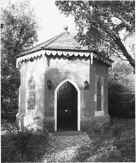
44. The pump room of 1859 at Purton Stoke spa.
Purton Stoke spa
Dr Samuel C. Sadler (d. 1889)
built a pump room in 1859 to exploit a mineral spring
which rose on Purton Stoke common. The spa was part
of his medical practice and in 1863 John Strange
managed the spa and a boarding house for patients,
which had closed by 1879, when the spa was managed by
Mr Greenaway. The spa declined in popularity but sales
of bottled water were revived by F. G. Neville between
1927 and 1948. (fn. 501) The small octagonal pump room
survives in good condition in 2010.
Quarrying and Brick making
The beds of Corallian
limestone on which Purton sits have provided serviceable
building stone, and around 20 important quarries are
recorded. (fn. 502) In 1921 Quarry farm was advertised for sale as
having a valuable bed of stone underlying the paddock. (fn. 503)
By c. 1900 there were two brickworks near the Great
Western Railway line, and by the mid 20th century clay
had been extracted mechanically from a pit at the Elms
alongside a factory and kilns. (fn. 504) Purton brickworks, owned
by the Hill family from 1906, supplied bricks for
Swindon's building trade until it closed in 1977. (fn. 505) By 1999
the old brickworks had been converted into a landfill site
and an industrial estate and recycling centre was under
Hills Waste management. (fn. 506)
SOCIAL HISTORY
Purton is an atypical Wiltshire parish, in consequence of both its tenurial history and its topography. In the medieval period its inhabitants were regulated by a somewhat ambiguous array of overlords: the Crown and its officers as guardians of the forest; Malmesbury abbey as spiritual and temporal lord; abbey tenants who behaved as manorial owners; and small freehold estates. Topographically the flat clayland of the north of the parish around Purton Stoke is quite different from the limestone ridge on which the main Purton village and its satellites emerged, and both seem alien to the wood pasture and woodland country of Braydon forest to the west. Any lack of social cohesion which such variety might be expected to generate, however, does not seem to have been a feature of Purton's recent history, as its smaller settlements have coalesced to produce an extended village comparable in size and population to nearby small towns such as Cricklade. In fact the range of welfare, recreational, social and cultural activities that Purton inhabitants have enjoyed implies a strong community bond.
COMMUNITY ACTIVITIES
In 1641 Play Close was given to the village by Henry Gleed, innholder, (fn. 507) to be used for parish sports including cricket until the late 19th century. Fields bearing such names were usually the village sports field, often of medieval origin and it may be that Gleed was simply restoring the field to its former use. (fn. 508) Purton cricket club, one of the earliest in England, was established in 1820 by John Mervyn Prower and other gentlemen. In 1909 James H. Sadler, who was partly responsible for building encroachment on Play Close, (fn. 509) gave the parish a new cricket field south of Church End. The club celebrated its 175th anniversary in 1995. (fn. 510)
The Workmen's Institute opened in 1889, fitted out with a reading room and other rooms for the use of parishioners. James H. Sadler built it in memory of his sister on land where the charity school had stood. From 1950–55 and from 1970 it housed the public library, which had since 1923 been held in the village school; and in 1990 a museum, created by Purton Historical Society, was opened on the upper floor. The building also houses the parish council office and was extended to include a parish hall. (fn. 511)
In 1908 Miss Warrender of Purton Stoke House gave a corrugated tin hut to the people of Purton Stoke as a meeting place for young people. It was used for Anglican church services and Sunday school meetings and as the headquarters of the Home Guard in the Second World War. Subsequently it became the Young Farmers' hall and is still used for other local meetings. (fn. 512)
In 1946 the Red House was purchased as a war memorial and village centre, with donations and a legacy from Mrs Proud, daughter of C. M. Beak of Purton Manor house. The rest of her legacy was used to build the village hall at the back of the Purton Institute. (fn. 513) The Millenium Hall was built to mark the year 2000 and is used by uniformed organisations including the scouts and guides.
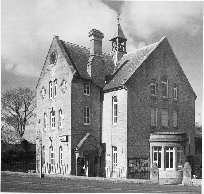
45. The Workmen's Institute, Lower Square. Built by James H. Sadler in 1889 in memory of his sister, it houses the public library, museum, and parish council offices.
Purton has been well served by its historians. S. J. Elyard's late 19th-century publications formed the basis of The Story of Purton by Ethel Richardson. (fn. 514) Her book Remembrance Wakes is an important record of the impact of the First World War on a rural community. (fn. 515) Purton Historical Society, established in 1960, has researched and fostered interest in the history of the parish, has published widely and has developed and maintains a museum. (fn. 516) Notable Purtonians are recollected with pride: Nevil Maskelyne, astronomer royal, James Kibblewhite, Olympic athlete and Desmond Morris, animal behaviourist. (fn. 517) To mark the millenium, maps were drawn and 26 stones recycled from historic buildings erected along the parish boundary, and a record of village life was published. (fn. 518)
Uncertainty surrounds the origin of the derogatory remark, 'do you come from Purton?', which is addressed to anyone leaving a door open. It was current in Richardson's time and it has been suggested that it refers to railway workshop employees from Purton delaying their train by holding open the doors for latecomers. (fn. 519)
46. The former Reading Room in Purton Stoke, donated to the community in 1909 by Miss Warrender of Purton Stoke House.
Inns
There have been many inns in the parish: most stood along the old road from Faringdon to Malmesbury, others served drovers passing through Braydon forest and adjacent commons, or travellers on the canal and railway. The earliest to be recorded was Church inn, formerly the church house at Church End, which belonged to the Gleed family in the mid 17th century. (fn. 520) Alehouse licences were granted to Leonard Pryddy, John Edes and John Pannell between 1575 and 1580, (fn. 521) and to Joyce Harburt in 1620. (fn. 522)
The Angel was the most important inn in the parish. It stands on the south side of High Street and belonged to Henry Gleed, the innholder who gave Play close to the village in 1641. (fn. 523) In 1786 John Warner sold it to John Bathe, who left it to his son William Bathe. He sold it to William Hinder in 1834, and his widow to David Tichener in 1854, who sold it to John Greenaway in 1857. In 1884 it was purchased by Arkells brewery. In the 18th and 19th centuries it was a meeting place for various bodies, including the vestry, and Purton Friendly Society, founded there in 1787. In the 1920s the Purton Scout group met in the function room, (fn. 524) which was used as a school room in the Second World War. (fn. 525) The present inn was built in 1704 and altered in the 19th century. The front sub-cellar belonged to an earlier building on the site and dates from c. 1600. The present building, of two storeys and three bays, has a double flight of steps to the main entrance, a central 20thcentury doorway with a fan-light above, and an 18thcentury basket arch linking to a back range. (fn. 526)
The George was a disorderly alehouse kept by William Wells in 1709, when the vicar and parish officers petitioned the magistrates to close it 'for our better and more peaceable living'. (fn. 527) The Red Lion had apparently closed in 1759. (fn. 528) The King's Arms occupied 4 and 5 High Street in 1841; later called the Queen's Arms, it was closed in 1909. (fn. 529) The Maltster inn, 7 High Street, a building of 1673, became a restaurant before it was closed in 1994. (fn. 530) The Old Bear, a beerhouse at 32 High Street in 1851, was closed in the 1860s. (fn. 531) In the 19th century several buildings at the western end of the village became inns, most of which have since closed: the Royal George in Pavenhill was a beerhouse in 1830. It was sold by Whitbread to Marr Taverns in 1992; (fn. 532) the Foresters' Arms at Pavenhill occupied a former farmhouse next to the Royal George dating from 1727, which was extended in 1863 and was a beerhouse until 1904; (fn. 533) the Masons' Arms on Upper Square was a beerhouse from 1841 until it was closed in 1955; (fn. 534) the Greyhound which opened at Pavenhill in c. 1858, became a freehouse in 1991 and was renamed the Home from Home; it was later renamed the New Greyhound, and closed in 2007. (fn. 535) The Live and Let Live at Upper Pavenhill was a beerhouse from 1860 until 1951 when it became a private house, although the inn sign remains. (fn. 536) The Spotted Cow, a canalside beerhouse on the Pry closed in 1862 once canal trade declined. (fn. 537) At Purton station a beerhouse was built in the 1840s, replaced by the New Inn built in 1862. It was called the Railway by the 1880s and renamed the Ghost Train after the station was closed in 1964; the Ghost Train closed in 2007. (fn. 538) In Station Road, Joseph Shurey took over the Hope beerhouse in 1859 and also ran his carpentry and undertaker's business from the premises. His family ran the inn for over 100 years and it was probably where the Purton Moonrakers met, supporters of Swindon Town Football Club. Bowleys, Simmonds, and Courage breweries owned it in succession. It became an Ushers pub in 1991, and is now used as a saddlery business. (fn. 539)
There were several inns outside Purton village: the Roebuck was a droving inn between Battlelake farm and Parkgate farm on Purton common in the early 19th century and Roebuck Cottage was demolished in the 1940s; (fn. 540) the Packhorse near Bentham on the main road to Cricklade was an inn c. 1773–1880. (fn. 541) The Bell had opened at Purton Stoke by 1822. (fn. 542) The licensee was prosecuted in 1844 for keeping a disorderly house. It subsequently became the property of Revd T. B. Carter, who leased it to Arkells from 1908, who bought it in 1926 and renovated it in 1969. (fn. 543) The Fox, which presumably gave its name to the row of 19th-century cottages near Church End, was an inn in 1841 but closed in the 1850s and is now a private house; (fn. 544) the Foresters' Arms, a beerhouse, occupied a cottage at Common Platt by 1851 and was an Inntrepeneur pub in 1992. (fn. 545) Six inns remained in 1999, and two, the Angel and the Royal George in 2010. (fn. 546)
Clubs and Societies
Many clubs and societies were founded in the late 19th and early 20th centuries. (fn. 547) The Boy Scouts were set up by Revd J. E. Pugh in 1910 and originally met in the loft at the Angel Hotel. (fn. 548) The Girl Guides were formed in 1922 and met in the cheese loft at College Farm. Mrs Ethel Richardson of Purton House became the first president and district commissioner. (fn. 549) Purton Tennis Club was founded in 1912, and Purton Football Club was founded in 1924. (fn. 550) The Women's Institute was begun by Mrs Ward of Red Lodge and the Red Cross branch by Mrs Sheppard in 1949. (fn. 551) In 1954 Silver Threads was founded for pensioners by Miss Elizabeth Ward; its hut was rebuilt as the Silver Threads hall in 1988. (fn. 552) A bowls club was formed in 1971, and a pavillion was opened in 1984. (fn. 553) In the later 20th century there were good sports and social facilities for residents of all ages, (fn. 554) and in 1999 there were 70 clubs and societies. (fn. 555)
In 1907 a branch of the Swindon Co-operative was established and despite political opposition from some leading residents, a new 'Co-op' shop was opened on High Street in 1909. In 1922 it moved to purpose-built premises on the site of the old village lock-up, an old sweet shop and a cottage in High Street. In the same year the Purton Co-operative Women's Guild began to meet in the Institute. The branch met for 57 years, eventually closing in 1979. The shop closed in 1993. (fn. 556)
EDUCATION
By her will Miriam Stephens (d. 1723) left an annual rent of £17 10s. from a freehold estate called Scissels or Ricketts, to educate poor children. (fn. 557) A school for 20 poor children was built in 1780, (fn. 558) with a school house for the master on land leased at a low rent by the earl of Shaftesbury. In 1788 the buildings were refurbished with financial help from the earl of Shaftesbury and Dr Maskelyne. In the 1830s the master taught 20 poor boys and around the same number of fee-paying pupils. By 1842 there were around 70 pupils. Boys and girls were taught separately and trained to participate in church services. The school was affiliated to the Anglican National Society. (fn. 559)
In 1786 the vicar, John Prower, set up Sunday schools funded by voluntary subscription at Purton Street and at Pavenhill. Testaments, prayer books, alphabet cards and spelling books were bought for the boys and girls to use. (fn. 560) In 1819 'numerous poor children' were taught in various schools and Sunday schools, which together had places for c. 270 pupils. (fn. 561) Several were Nonconformist Sunday schools, including one run by the Congregationalists. (fn. 562) There was also a school for children in the workhouse. (fn. 563) By 1858 the old charity school building was inadequate for the 50 boys and 50 girls taught there. (fn. 564) It was eventually replaced by the Workmen's Institute in 1889 and the stone tablet recording the school's original endowment was incorporated in the front of the institute. (fn. 565)
St Mary's, the new school, designed by E. W. Mantell of Swindon, was built on lands obtained from Worcester College, Oxford in 1859. An infant school, designed in 1873 by architect J. Phillips of Devizes, was added to the building, (fn. 566) enabling many more pupils to be accommodated, (fn. 567) 271 in 1871, (fn. 568) and 299 in 1877. (fn. 569) A non-denominational school was built on the Cricklade road at Purton Stoke in 1898 on land given by Mr Story-Maskelyne. Pupils learned cheese and butter making at Pond Farm. (fn. 570) The overall number of schoolchildren fell in the early 20th century, (fn. 571) and in the 1930s St Mary's school was altered to accommodate secondary pupils and when war-time evacuees swelled numbers, classrooms were set up at Playclose Methodist chapel and the Angel inn. Following the 1944 Education Act three large classrooms were built, which included the 'practical block' for woodworking and domestic science. (fn. 572)
In 1963 Bradon Forest school was opened for secondary pupils, built partly on St Mary's playing fields. (fn. 573) It became a comprehensive school for pupils aged 11–16 during the 1970s, and attendance rose from around 600 in 1982 to more than 1,100 during the 1990s, largely in consequence of Swindon's western expansion. (fn. 574) It became a grant-maintained school in 1993. (fn. 575) St Mary's became a primary school for pupils aged five to eleven and both the original site and the new playing field site were developed c. 1968–70. The number of pupils at St Mary's peaked at 460 in 1975, after which it levelled off and stood at c. 260 in 1988. In 1993 it was incorporated as a grant maintained school. (fn. 576) In 1978 Purton Stoke school closed amid controversy and c. 30 pupils were transferred to St Mary's. (fn. 577) In 1988 Purton also had an under-fives playgroup, and a Sunday school run jointly by members of the Anglican and Methodist churches. (fn. 578)
CHARITIES
In 1631 the Crown granted the villagers of Purton Stoke 25 a. producing an annual income of £37 10s. in lieu of common rights in Braydon forest. (fn. 579) The income from Purton Stoke Poor's Platt charity was subsequently used by the parish overseers to support poor people from other parts of the parish. In 1734 the inhabitants of Purton Stoke took the overseers to court and had this policy reversed. (fn. 580)
In 1640 Epaphroditus New gave £30 to the poor, which was probably used to buy c. 2 a. on Purton common called John Hiscock's leaze. Rental income was £1 7s. in 1816 and £3 in 1867–9, which was distributed to the poor on Good Friday. By 1908 the pasture was let with the lands of Gleed's charity and the incomes were distributed together. (fn. 581) Francis Gleed of Purton, who became sheriff of Bristol, gave £200 by will to the poor and 13 a. of pasture was purchased at Cross Lanes. Poor households not in receipt of weekly poor relief were paid 10s. at Christmas from the income. The charity was also awarded 4½ a. next to Hiscock's leaze as compensation for loss of common rights at inclosure in 1738. In 1816 rental income was £14 13s. plus the interest on £10 compensation for land purchased by the Wilts. & Berks. Canal company. Rents rose to £21 in 1834, when the small field was amalgamated with Hiscock's leaze to form one 6½ a. field of poor quality land. By 1901 almost £40 was distributed annually. (fn. 582) From 1910 Gleeds and Hiscocks were known as the 'United Charities'. (fn. 583)
In 1644 Thomas Jacob of Wootton Bassett left 40s. by will for his son-in-law Nevil Maskelyne to distribute to the poor, (fn. 584) and in 1679 Nevil Maskelyne left lands which produced an annual rent of £5 10s. for the poor who were not in receipt of poor relief. (fn. 585) In the early 20th century Maskelyne's charity became known as the 'Good Friday charity'. A shilling or more was distributed to each aged poor person at church on Good Friday as late as 1954. (fn. 586)
Church offertory money was distributed regularly by the vicar to the poor who were in the greatest distress. (fn. 587) Subscriptions to Purton Friendly Society founded in 1787 paid for the funerals of members who had fallen into poverty and the society held an annual church service and feast on Thursday in Whitsun week. (fn. 588)
Mr and Mrs Wykeham-Martin built and furnished a cottage hospital in Hyde Lane in 1877, which was maintained by private subscriptions and treated about 500 patients during its first decade. It became a children's convalescent home c. 1888 and was later converted to a private residence. (fn. 589)
LOCAL GOVERNMENT
MANOR
The abbot of Malmesbury's right to hold manor courts, including view of frankpledge and assize of bread and ale, on his manor of Purton was by the 13th century exercised by Robert de Keynes (d. 1281), and his heirs. (fn. 590) In the late 14th and early 15th centuries the main business of the courts was regulating tenancies, (fn. 591) and the customary right to pannage for pigs in the woods. (fn. 592) In the early 16th century the woodwards at Purton Poucher manor court presented those who were clearing woodland; (fn. 593) and in the later 16th century the main business of Purton Wootton manor court was regulating tenancies. (fn. 594) Manorial custom continued to govern the appointment of court officials, inheritance, and grazing and timber rights in Braydon forest in the decades around 1600. (fn. 595) In the early 18th century the main business of Purton manor court was electing court officials, constables, and haywards who regulated grazing on the commons: the last court was held in 1740 after the inclosure of Purton's commons. (fn. 596)
PARISH
A rates list survives from 1665, (fn. 597) and records of parish constables, (fn. 598) surveyors of the highways, (fn. 599) and overseers of the poor, (fn. 600) survive from the early 18th century. Purton and Braydon both came under the authority of Cricklade and Wootton Bassett Rural Sanitary District from its formation in 1872 (Rural District Council from 1894) until 1974, when that authority became part of North Wiltshire District Council, which was abolished in 2009. (fn. 601) The inauguration of Purton parish council in 1895 was marked by the publication of a history of Purton charities. (fn. 602)
WELFARE
In 1625 parishioners complained that poverty-stricken occupants of more than 60 recently-built cottages were an insupportable charge on the poor rate. (fn. 603) In 1641 Henry Gleed, innholder, gave the parish a house called Weekes, on Purton street east of the Angel inn, as an almshouse. The gift included a parcel of land called Church house, later Play close. The name 'Church house' suggests that both house and close were parish property which escaped confiscation at the Reformation and which Gleed held in trust for communal purposes. (fn. 604) By 1725 the building was described as the workhouse. (fn. 605)
An average of 18 workhouse inmates 1737–69 had risen to 30 by 1803, when a cottage at Dogridge provided further accommodation for the poor. (fn. 606) In 1813 Purton poor rate raised £2,035, to support 145 people on permanent relief and 10 more on occasional relief, supplemented by £139 of charitable donations. (fn. 607) The sum required decreased in the following years, peaked again in 1818 when £1,891 was raised, decreased to an average of £1,300 between 1819 and 1830, and peaked again in 1832 at £2,037. (fn. 608) In order to reduce the number of those receiving permanent poor relief, Purton overseers subsidised emigration to Canada in 1837 and 1844. (fn. 609)
Purton and Braydon were both in Cricklade and Wootton Bassett Poor Law Union, formed in 1835. (fn. 610) The rising number of workhouse inmates necessitated a new union workhouse, (fn. 611) designed by architect G. Wilkinson in 1837 and built of red brick on the south side of the High Street at Dogridge. (fn. 612) In 1838 the Board of Guardians sold the old workhouse and 20 cottages, which once housed those receiving outdoor relief, although out-relief continued to be paid. (fn. 613) Behind the new main building with its nine-bay classical façade was a square complex of yards and workrooms including a piggery. There were separate wards for men and women and for specific categories of inmates, including wards for the sick erected in 1840, and an outhouse for tramps. The number of inmates declined after the introduction of old age pensions and health insurance in 1908 and 1911, and those who remained were mainly aged, infirm and mentally handicapped. A new ward was established in 1932 for mentally handicapped children, (fn. 614) and from 1929 the other workhouse children lived in a house called Red Gables on Restrop Road. (fn. 615) In 1932 male patients were transferred to the workhouse at Stratton St Margaret and Malmesbury cottage hospital cared for unmarried mothers. The workhouse became a home for mentally handicapped women and was renamed North View Hospital. (fn. 616) In 1989 all but the main building was demolished and the remaining residents were transferred to a single-storey purpose-built home behind it, North View House. (fn. 617) The Cedars, a Georgian mansion on High Street, became a County Council residential home in 1948 and was rebuilt in 1984 as a more convenient modern building. (fn. 618)
WATER SUPPLY
A mains water supply was installed and a water tower was built at Pavenhill in 1927 (demolished c. 1975), although not all residents paid to be connected. (fn. 619)
RELIGIOUS HISTORY
Malmesbury abbey controlled Purton's religious life throughout the Middle Ages. After the Reformation the owners of the largest estates were absentee landlords: church life was dominated by local gentlemen and wealthy farmers; and from the late 17th to the late 19th centuries by clerical dynasties, the Glass and Prower families. Despite the decline of organised religion in the late 20th century religious life continued to flourish, centred around Anglican and Methodist worship in the early 21st century.
PARISH CHURCH
It is likely that Malmesbury abbey built a church on its Purton estate before the Norman conquest, although no such church is recorded in Domesday Book in 1086. (fn. 620) A church at Purton was listed among the abbey's possessions in 1151 and in 1177 Pope Alexander III licensed the abbey to appropriate it. (fn. 621) Although the license was renewed by Celestine III in 1191, it seems not to have been acted on. There is, however, some evidence to suggest that the church paid the abbey a pension; according to Abbot William (probably William of Colerne, 1260–96), the rector of Purton customarily paid the convent four marks. (fn. 622) The abbey formally appropriated the church only in 1276, when the last rector, Master Bayamund de Vicia, resigned in return for an annual pension of £20 for life. By then there was already also a vicar. (fn. 623)
Advowson
Malmesbury abbey from at least 1151 until 1276 presented the rector. Thereafter until 1515, when the advowson was leased to Richard Pulley and his heirs, it appointed the vicar. (fn. 624) With the dissolution of the abbey in 1539 the advowson reverted to the Crown, (fn. 625) and in 1544 it was granted with the rectory estate to Edmund Bridges (d. 1573). (fn. 626) His heirs held the advowson until 1610, when Gray Bridges, Lord Chandos (d. 1621) sold the estate to Anthony Ashley. (fn. 627) The advowson remained the property of Ashley's descendents, later the earls of Shaftesbury, although in 1771 the bishop of Salisbury presented John Prower (d. 1827) to the living. In 1960 the advowson was transferred from the earls of Shaftesbury to the bishop of Bristol. (fn. 628)
Value and Property
The living was relatively wealthy. When acquired by Abbot William of Colerne in 1276, the church was said to be worth 50 marks (£33 6s. 8d.) a year, and in c. 1291 the rectory was valued at £16 and the vicarage at £5 a year. (fn. 629) The church with its vicarage was still valued at £21 in 1428 and in 1536, by then leased to Richard Pulley, it was worth £22 17s. 6d.. (fn. 630)
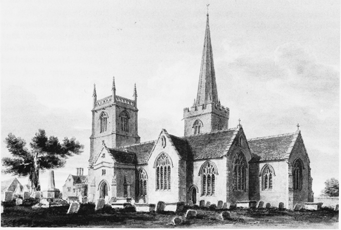
47. Parish church of St Mary and churchyard cross from the southeast c. 1810, a cruciform church of Norman or earlier origins to which a spire and second tower were added in the later Middle Ages.
In 1276 a vicarage had recently been built, together with two other houses. (fn. 631) In 1341–2 the vicarage and garden were worth 3s. 4d. annually, and a yardland and 4 a. of land were worth 40s. Income from tithes then was low because many sheep had died the previous winter. (fn. 632) A 1588 terrier of lands which paid lesser tithes to the vicar was used as the subsequent basis for collection. In the 17th century the glebe included a house with a barn, yard and garden, the churchyard and three farmsteads at Bentham, Pavenhill and Restrop, (fn. 633) and in c. 1640 the glebe included four beasts' leazes on the commons. (fn. 634) In Purton the tithe system broke down during the Interregnum, (fn. 635) and in 1661 following the Restoration, there was resistance to paying tithes to William Aldford (vicar 1629–64) and his successors. (fn. 636) When Momes leaze was inclosed in 1733, the vicar was awarded 18 a. in compensation for loss of tithes. (fn. 637) John Prower (vicar 1771–1827), exchanged several parcels of glebe for lands closer to the vicarage. (fn. 638)
In 1835 the living was valued at £690 p.a. (fn. 639) In 1887 the glebe estate of 53 a. provided the vicar with an income of £127 7s. (fn. 640)
Parish registers survive from 1558 with some gaps in the 16th and 17th centuries. (fn. 641) The marriage registers are published up to 1812. (fn. 642)
RELIGIOUS LIFE TO 1600
Although in the 19th century a document of 1336 was interpreted to suggest that the church was then dedicated to St Nicholas, it seems likely that it was always dedicated to St Mary. (fn. 643) Purton's special association with the Virgin is already indicated in 1177 by the pope's assignment of the church, at the request of the abbey, to mantain a weekly commemoration of the Virgin. Certainly it was dedicated to the Virgin in 1268 when Philip Paynel, grandson of Adam of Purton, was baptised there by Richard the vicar. (fn. 644)
The baptism of someone as important as Philip Paynel by the vicar indicates that the last rector, Bayamund de Vicia, who was also dean of Lynn (Norf.), was absentee. The vicarage near the church was recorded as new in 1276 which suggests the institution of a vicar to serve an absentee rector may have been a recent development. By then Richard had been replaced: he is recorded as 'lately' vicar in the act of appropriation. (fn. 645) Little is known of his medieval successors, all presumably appointed by the abbey. John Franklyn (d. c. 1516), vicar at the time of the lease of Purton manor to Richard Pulley in 1515, was clearly resident and soon fell out with the new farmer when the latter caused great strife among his parishioners by seeking to enclose land on Purton hill over which they had common rights. (fn. 646)
The ambition and quality of the late 13th- and 14thcentury work at Purton may reflect the wealth of Malmesbury abbey. Probably it also owes something to the generosity of wealthy local benefactors. John Aubrey, writing c. 1659–70, recorded that stained glass in the church included the arms of the Keynes and Paynel families, who may have had some responsibility for refurbishing the church. (fn. 647) A large medieval stone coffin, dug up in the chancel in 1761, perhaps belonged to a benefactor. (fn. 648)
The medieval church was lavishly adorned. Aubrey remarked on the large number of niches and corbels which survived in his day; many still exist as evidence that the exterior and interior of the pre-Reformation church was rich in images. (fn. 649) In the late 14th century, a distinguished sculpture of the Annunciation was installed, originally probably inside the church, although by the 17th century it was in a mutilated condition and outside, under the east window. (fn. 650) A cycle of wall paintings of scenes from the life of St Mary was painted on the south wall of the south chapel in the later 14th century. It included a fine depiction of the 'Death of the Virgin' which survives after being uncovered in the 19th century. (fn. 651) A squint between the south chancel chapel and south transept, which has its own piscina, suggests the chancel chapel and transept may have been used together as a Lady chapel. The process of enrichment continued throughout the later Middle Ages and more paintings were added in the 15th century. Above the arch at the western entrance to the south transept another series of murals has at its centre a group of angels, flanked to the north by a Noli me tangere scene, where St Mary Magdalene greets the risen Christ, and to the south by St Michael weighing souls with the Virgin tipping the scales. (fn. 652) A 'Doom', depiction of the Last Judgement, now covered over, was painted over the chancel arch, (fn. 653) and the wall of the south aisle was adorned with a 'Christ of the Trades' painting depicting a fulling mill and various craft tools, part of which still survives. Probably in the same century, a heraldic badge of the Virgin Mary was painted in the south porch. (fn. 654) Also in the 15th century high-quality stained glass was installed in the windows of the north aisle and the transepts, fragments of which survive, gathered together in the south window of the south chapel in 1927. (fn. 655)
The church's images were enhanced by votive lights burning before them, the cost of which was supported by rent from several small parcels of land. 'Lamp Acre' in Gosty Mead funded a light in the church. (fn. 656) A half acre of 'Lamp Land' in the Hurne and other rents funded more lights, including one before the image of the Trinity. (fn. 657) The church also had a gild of St George, which was responsible for maintaining a priest and an image of the saint in the parish church together withtwo ale stewards who supervised the brewing of ale to fund its activities. (fn. 658)
At the Reformation the vicar, Richard Gabell (1547–55), survived the changes after the death of Edward VI and was succeeded by his curate Thomas Roberts (1555–70). (fn. 659) Despite such stability among the clerical personnel, there were great changes in the church. In January 1548, John Messenger, who together with Benet Joy was churchwarden of Purton, with several neighbours pulled down all its images, shutting them in 'a corner' of the church, intending that they should be sold and the money 'put into the poor men's box'. Joy's wife, Isabel Pulley, 'much liking' the image of St George (evidently one of the most prized) and thinking 'it was pity to deface the same', was allowed by Messenger to remove it to her residence at Purton manor. Sir Edmund Bridges, who was then in dispute with Joy and his wife, as lessees of the manor and the living, later came with six companions and retrieved the image from the Joy's well-house. (fn. 660) Its fate thereafter is not recorded.
Probably around this time, the medieval wallpaintings were whitewashed over and a painting of the Ten Commandments in a cartouche supported by Moses and Aaron was installed. (fn. 661) The king's commissioners came to the church in 1552 and left only a single chalice and four bells, having confiscated 1½ oz. of plate; this meagre haul for what had evidently been a rich church implies that much had already been disposed of. (fn. 662)
Despite all the changes, there seems to have been a vein of religious conservatism in the parish, focused perhaps on the Pulley family, former farmers of the manor. Jane, the niece of Isabel Pulley and wife of George Maskelyne of Purton Down, left 20s. 'to the bells of Purton' in her will made at the end of the reign of Elizabeth I, indicating perhaps a special family interest in the church tower. (fn. 663) She also made further provision for 'the yearly maintenance of one to play upon the organs' in the parish church, whensoever, as she sadly noted, the parishioners should see fit to hire someone for that purpose. (fn. 664) The churchwardens, moreover, appear successfully to have concealed the lands given for 'superstitious purposes', namely the maintenance of lights and masses for the dead, well into the reign of Elizabeth, applying the funds raised from them to the use of the church. An inquisition held in 1592 found that as late as 1582 the lands were still be let out to George Maskelyne and his son. (fn. 665)
William Aldford (vicar 1629–64) held the benefice throughout the political upheavals of the mid 17th century. His survival may in part be due to the patronage of Anthony Ashley Cooper, lord of the manor from 1631, whose political and religious stance was ambiguous. By contrast, the Hyde family of what was to become College farmhouse, were strongly royalist and there in 1652 Mrs Susan Hyde offered refuge to William Haywood, a prebendary of St Paul's, who had lost his living in 1642 on account of his 'ceremonialism'. (fn. 666)
ANGLICAN RELIGIOUS LIFE FROM 1660
Beating the parish bounds lapsed during the Interregnum but the custom was revived at the Restoration and survived into the 18th century. (fn. 667) To succeed William Aldford in 1664, the earl of Shaftesbury appointed William Bathe, member of a prosperous Purton farming family. (fn. 668) He served the living from 1664 until 1714, even longer than his predecessor. Bathe was probably responsible for refurbishing the church plate, a chalice and paten inscribed with the date 1666, but apparently of much earlier workmanship. (fn. 669) By 1679 the Maskelyne family had acquired the right to be buried in the south transept, where their memorials remain. (fn. 670) They claimed exemption from burial fees because of their 'ownership' of the south aisle, but refused to contribute to its maintenance. They therefore forfeited their right to the earl of Shaftesbury, who erected seats in the aisle for himself and his servants in addition to those he possessed in the chancel as impropriator of the Rectory estate. (fn. 671) By 1698 Francis Goddard of Purton House also had seats for himself and his household in the south aisle. (fn. 672)
Bathe was followed by two generations of the Glass family, father and son, both named Richard (1715–48). (fn. 673) The younger Richard's son, Revd Samuel Glass (1734–1812), was born at Purton and became wellknown for his role in public debate and for promoting the Sunday school movement. (fn. 674) In the later 18th and 19th centuries, the Prower family were an important influence on the religious life of the parish. John Prower (1771–1827) held two services each Sunday and services on church festivals, with communion services four times a year. He taught children their catechism during Lent, (fn. 675) and set up Sunday schools at Pavenhill and Purton Street in 1786, and another at Purton Stoke in 1788. (fn. 676) In his time, in 1773, the church was reroofed and the nave ceiled. Prower, however, refused to pay for the chancel roof, which it was the duty of the impropriator to repair, so the parish had it reroofed but left it unceiled. (fn. 677) Despite these difficulties, in 1782 the dowager countess of Shaftesbury gave the church a 17th-century Flemish painting of the Last Supper, which now forms part of the reredos. (fn. 678) In 1820 the church was given a second paten, dating from 1708. (fn. 679) The arms of George III were placed on the north wall of the tower, and those of the house of Hanover c. 1837 were placed over the south door. (fn. 680)
Prower was succeeded in 1828 by his son John Mervyn Prower (1784–1869), (fn. 681) who served as vicar until his death. He was appointed rural dean of Cricklade and an honorary canon of Bristol cathedral. The family gave silver plate to both Purton and Braydon churches. (fn. 682) The Prowers were efficient and were praised for their pastoral care, but were criticised for not engaging in the religious controversies of their day. (fn. 683)
By 1835 the church had a three-decker pulpit at the centre of the nave, a west gallery for musicians and further galleries along the south wall of the nave and in the north transept. (fn. 684) By then it had seating for 600 people, (fn. 685) while in 1851 there were 700 seats, 400 of them free. (fn. 686) On the morning of Census Sunday in 1851, 350 people attended the church and 100 children went to Sunday school. In the afternoon 250 attended church and 100 Sunday school. (fn. 687)
Prower's successor Walter Mitchell, vicar until his death in 1874, (fn. 688) oversaw a thorough restoration of the church in 1872, towards which Canon Prower's son, Major Prower of Purton House, donated £1,000. (fn. 689) The church was completely reordered. The pulpit and reading desk were removed, some of the panelling being re-used in Stanton St Quinton vicarage, itself remodelled in 1872. (fn. 690) The church was also given new plate, consisting of a medieval-style chalice, paten, cruet and flagon to mark the restoration. (fn. 691)
Under John Veysey (vicar 1878–1916), new stained glass was installed and oak choir stalls and a screen at the west entrance were erected in 1893. At the same time, the octagonal font was rescued from a cottage garden and returned to the church. (fn. 692) In 1897 a lectern was given to commemorate Queen Victoria's Diamond Jubilee. (fn. 693) Veysey's successor, R. B. Harrison (vicar 1917–27), (fn. 694) introduced High-Church services and choral services at the workhouse on church festivals. (fn. 695) A new organ was purchased in 1919 and in 1920 a pulpit was erected in memory of vicar John Veysey (d. 1919). (fn. 696) Panelling in the Lady chapel also dates from the 1920s. (fn. 697)
Later vicars included Canon Norman Willis (1927–74), who was a diligent chaplain of the workhouse 1928–60, (fn. 698) and Canon Roy Blake, vicar 1974–93. (fn. 699) Minor changes to the interior of the church in the 20th century have included placing three stone statues in medieval niches in 1928 (fn. 700) and a replica of a 14th-century copper alloy figure of Christ from a crucifix found in Vastern Close in the Lady chapel, (fn. 701) as well as the removal of the upper part of the reredos in 1962. (fn. 702) After Braydon church was closed in 1980, its altar was moved to St Nicholas' chapel in the south transept and its memorials to the north-west wall of the nave. (fn. 703) In 1988 St Mary's church hosted a festival of village life which involved many local groups, and in the same year church members went on pilgrimage to the Holy Land. (fn. 704) In 1989, two bells were added to the peal of six, already installed by the early 20th century, the earliest dating from 1598. (fn. 705)
In 2004, B. A. Fessey, vicar since 1994, was succeeded by Jane Haslam, Purton's first female vicar. (fn. 706)
Church building
Purton is one of only three English medieval parish churches with both a central tower with spire and a west tower. (fn. 707) It stands on a slight rise at the bend of the road, the west tower closing the view east.
Built of coursed limestone rubble with stone slate and lead roofs, the church is the product of several phases of building although the exterior is largely Perpendicular in style. By the early 16th century the church had assumed its present almost symmetrical form and consisted of a nave with north and south aisles, a central tower with north and south transepts, a chancel with a sacristy to the north and a chapel to the south, and a west tower. It seems likely that a cruciform church with central tower existed in the 12th century if not before. The east respond of the south arcade may be 12th century and one re-used carved stone survives ex situ. Otherwise the earliest fabric is of c. 1200 when the nave, which has north arcade capitals with octagonal abaci and carved leaves, was built. The capitals of the south arcade piers are more plainly moulded with circular abaci, suggesting that arcade was built a little later. (fn. 708) The chancel was rebuilt later in the 13th century. In the south wall a large piscina survives and two lancet windows can still be traced, although the one on the north is filled in and the one on the south is partly built up. (fn. 709)
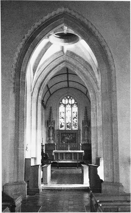
48. Parish church of St Mary, looking east from the nave into the 14th-century crossing and 13thcentury chancel.
An ambitious remodelling of the church was carried out during the 14th century, starting at the east end. A chapel was added on the south side of the chancel and an archway created to connect chancel and chapel, which retains a piscina in the south wall, and a fine three-light east window with flowing Decorated tracery. That work was followed by the construction to a unified design of a vaulted crossing, crowned by a tower and spire, and of symmetrical transepts. A staircase leads from the north transept to a high tower chamber, formerly divided into a lower bell-chamber and an upper chamber.
The 15th-century alterations were extensive. The decorative programme and changes to the chancel were lavish, but the alterations made to the nave indicate that the parishioners were economical there. The nave was heightened and about three feet of stone was added to the piers, but the old capitals were re-used under new arches formed with many of the old stones. The south aisle was widened and both aisles were rewindowed. A south porch was added, with heated accommodation for priests in an upper storey and an elaborately carved niche. To the west of the blocked north door to the nave is a similar niche similar to that in the porch; both have traces of colour. (fn. 710) In the chancel the windows were replaced and the east one flanked by niches with another beneath, now destroyed. Other new stone fittings included sedilia, an Easter sepulchre and two Perpendicular panels behind the choir stalls. The last part of the east end to be built was the small north addition, perhaps always intended as a sacristy. (fn. 711) The west tower appears to predate the nave. It stands at a slight angle to the nave, possibly with the intention of creating a significant landmark in the view of church and manorial site. The topmost stage and decoration with elaborate niches are contemporary with the other 15th-century embellishment. (fn. 712) The church underwent a major restoration in 1871–2. The architect was William Butterfield, whose tiled floor and benches survive. (fn. 713)
In the churchyard opposite the south chapel stand the steps, base and stem of a stone cross. (fn. 714) Lord Shaftesbury donated land to extend the north side of the churchyard in 1872, (fn. 715) as did C. M. Beak after he purchased Purton manor house in 1895. (fn. 716) A very ancient yew tree with a hollow trunk stands in the churchyard not far from the south porch.
Vicarage houses
The house recently built in 1276 by Richard, the late vicar, stood by the entrance to the church. (fn. 717) It was in good condition in 1341–2, (fn. 718) but was dilapidated in 1410. (fn. 719) The vicarage which stood to the east of the church until 1912 was built of stone with a stone slate roof, and probably dated from the late 15th century. In 1778 the best parlour in the vicarage was refurbished with new windows, a marble chimney piece and wainscoting. In 1793 the house was re-fronted and it was extensively remodelled in 1834. (fn. 720) It was demolished in 1912 and the churchyard was extended to allow for more burials. (fn. 721) A new vicarage, a double-pile construction, incorporated stone, architectural features and woodwork from the earlier vicarages, notably a 14th- or 15th-century carved head; a window above the main entrance, a stone fireplace, moulded beams and panelling by the front door, of c. 1500; and a staircase of c. 1700. It remained the vicarage until 1987 when it became the Pear Tree hotel, and Churchfield Lodge in Church Street, a smaller house, became the vicarage. (fn. 722) In 2004, the vicarage moved again, to 2 Kingsacre in Hyde Lane. (fn. 723)
PROTESTANT NONCONFORMITY
Quakers
Most of the 18 Nonconformists living in the parish in 1676 probably belonged to a Quaker group recorded at Purton Stoke in 1678. (fn. 724) This meeting flourished in the late 17th and early 18th centuries, when its membership was drawn from as far afield as Mildenhall. (fn. 725) There were 37 male and 48 female regular attenders between 1670 and 1700, and some members emigrated to America. (fn. 726) Illegal meetings held at Margaret Shurmer's house were investigated by local magistrates in 1683. (fn. 727) In 1690, shortly after Nonconformist worship was legalised, her house was licensed for meetings. (fn. 728) By 1705 the Quakers had built a meeting house in the garden of Jordans, a farmstead occupied by Jonas Bath on Purton Stoke street. (fn. 729) They later owned their own burial ground. (fn. 730) The group had disbanded by 1759, (fn. 731) and in 1832 their meeting house was sold to the Primitive Methodists. (fn. 732)
Congregationalists
In 1824 William Greenaway's home was licensed for Independent worship and in 1825 a licence was granted for Job Lewis's barn. (fn. 733) A chapel was built in 1829 on Purton High Street with assistance from the Congregational Association. (fn. 734) Later the Brinkworth mission opened a Congregational school. (fn. 735) In 1851 on Census Sunday 18 children attended morning Sunday school and 90 and 40 people attended afternoon and evening services respectively. (fn. 736) In 1922 the number of worshippers had fallen because of competition from the Upper Square Primitive Methodists and the building was offered for sale to their trustees, who eventually became tenants. The building was used as a canteen for servicemen in the Second World War, but was demolished in 1969 and a Scout hall was built on the site. (fn. 737)
Methodists
John Wesley rode through Purton in 1740 and 1741 but no Wesleyan meeting resulted. (fn. 738) Primitive Methodist meetings were established in the early 19th century, as part of the Brinkworth circuit. (fn. 739) In 1828 the homes of John Hunt and Uriah Moall were licensed for worship, (fn. 740) and in 1829 there were twelve Primitive Methodists in Purton. Early meetings held under an elm tree in Witts Lane and in members' homes attracted violent opposition, but in 1843 members bought a cottage which they converted into a chapel. (fn. 741) On Census Sunday in 1851, 80 people attended the morning service and 100 the evening service. (fn. 742) In 1856 a larger chapel was built near Upper Square on Hoggs Lane; (fn. 743) the congregation had almost doubled by 1893 when the chapel and meeting rooms were enlarged again. A manse was built for the minister in 1953 and the chapel was thriving at its centenary in 1956.
Nonconformist chapels
A Wesleyan Methodist chapel, part of the Swindon circuit, was built at Play Close c. 1868 by architect Thomas Smith Lansdown of Swindon, (fn. 744) and in 1882 was replaced by a larger building erected by Thomas Barrett, builder of Swindon. In the late 19th and early 20th centuries members of both Upper Square and Play Close chapels enjoyed a full programme of services, Sunday school activities and social events for all age groups. In the 1960s, however, membership of both chapels declined and following major restoration work Play close chapel re-opened in 1973 as their joint home. Upper Square chapel was sold and became a private house. (fn. 745) Play Close chapel's centenary was celebrated in 1982. (fn. 746) In 1988 it hosted Play Close playgroup, catered for disabled groups and its members ran Purton United Junior Church jointly with the Anglicans of St Mary's church; (fn. 747) it continued to be used regularly in 2010. (fn. 748)
Primitive Methodists built a new chapel on the site of the old Quaker meeting house on Purton Stoke street, which they had purchased in 1832. (fn. 749) On Census Sunday in 1851, 60 people attended the afternoon service and 50 the evening service. (fn. 750) By 1868 the congregation had outgrown this building and it was sold in order to buy the site of the present chapel, which reuses material from its predecessor. (fn. 751) A school room was built on land acquired in 1905. In 1907, with 76 adult members and 106 Sunday school children, the chapel had the highest attendance of any in the Brinkworth circuit. Although membership declined over the course of the 20th century, it remained in use in 1999; (fn. 752) by 2008 it had been converted for use by a Christian dance troupe called NCounter, although it continued to be used occasionally for services. (fn. 753)
BRAYDON
PARTS of Purton parish lay within the bounds of Braydon forest, at its greatly reduced extent defined by perambulations in 1300 and 1330. (fn. 754) These included the hamlet or tithing of Braydon, the central part of the ancient forest, (fn. 755) which became a separate civil parish in 1866. (fn. 756) This section is concerned with the tithing and civil parish; the significance of Braydon forest to the history of the parishes described in this volume is discussed in the Introduction above.
Boundaries
Braydon civil parish is a wedge-shaped area of land narrowing from c. 2 km at its eastern boundary with Purton to c. 0.5 km at its western boundary with Charlton. (fn. 757) Purton lies also to the south, and Cricklade lay to the north until this area was transferred to Purton in 1984. Part of the northern boundary was first described in c. 1300. (fn. 758) Part of the eastern boundary is formed by the Key (fn. 759) and its western boundary by a road to Minety. The boundaries of Duchy wood on a map of 1632 are those of the modern parish, (fn. 760) which in 1879 covered 1483 a. (601 ha.) in 1981. (fn. 761)
Landscape
The land slopes from 134 m at the western boundary with Charlton to 85 m at the eastern end, the lowest point of Braydon forest. (fn. 762) A low hill, called Langhox or Langhopps hill in the 17th century, lies near the centre. The soil is Oxford Clay. A tributary of Derry brook crosses the western end and the Key and its tributaries pass through the eastern half, where the land is marshy and the river and its tributaries are liable to flood. Most ancient woodland and wood pasture was cleared after 1630, so that little remained by 1773. New plantations were made in the 19th century, so that in 1839 c. 20 per cent of the tithing was again wooded, and a similar proportion remains. (fn. 763)
Communications
Roads
The medieval road from Oxford and
Faringdon through Purton to Malmesbury and Bristol,
and the clearing along which it ran, form Braydon's
southern boundary. (fn. 764) A north–south road from
Cirencester to Wootton Bassett, turnpiked in 1810 and
disturnpiked in 1863, bisects the tithing. (fn. 765) Two minor
roads running south from Minety Common cross the
parish, following straight 17th-century enclosure
boundaries. (fn. 766)
Railway
The Cheltenham & Great Western
Union Railway, opened in 1841 and still in use, clips the
north-eastern corner of the civil parish. (fn. 767)
Population
Purton parish total included a separate figure for Braydon's inhabitants from 1821 when 70 people lived there, a number which declined to 48 in 1881, rose to 74 in 1931 and declined to 64 in 1951 and 47 in 1991. (fn. 768)
Settlement and Built Character
No evidence of prehistoric, Romano-British or AngloSaxon settlement has been identified within the boundaries of the civil parish. In the Middle Ages Braydon belonged to the duchy of Lancaster, which later became Crown property. The area was known as Duchy wood by 1595 and was sold by the Crown in 1826. (fn. 769) Medieval and later settlement was always sparse in this part of Braydon forest. (fn. 770) Hatton's Lodge was an isolated Royal hunting box until the Crown developed the land in the 17th century. (fn. 771) White Lodge and Maplesales farmsteads were built in the mid 17th century, (fn. 772) and more dwellings were built in the later 17th and early 18th centuries when there was an influx of poor inhabitants. (fn. 773) In 1887 the area was said to be 'occupied chiefly by squatters, who led a wretched life'. (fn. 774) Although a school and chapel-of-ease were built in the later 19th century, they subsequently closed, and Braydon remains an area of isolated farms and scattered cottages.
LANDOWNERSHIP
Although the land that became Braydon tithing was presumably part of Malmesbury abbey's pre-conquest Purton estate, the King owned Braydon forest, part of which was in Purton. Over the centuries certain lands were granted out to royal servants and religious institutions, who established rights over them. These included Malmesbury abbey, which was granted free warren in its demesne lands of Purton and Braydon in 1328; (fn. 775) and the lord of Wanborough manor, who claimed rights in the forest before 1245 by view of the woodward and bailiff of Aldbourne. (fn. 776) The Crown retained some lands for its own use and other lands returned to the Crown's possession and remained in hand. The land that was or became Braydon tithing was held before 1245 by William Longespeé, earl of Salisbury, as parcel of his manor of Aldbourne, and descended by marriage successively to Henry de Lacy, earl of Lincoln, and Thomas, earl of Lancaster. (fn. 777) In 1342 Henry, earl of Lancaster and Derby, bought 106 a. which had been part of Purton manor. (fn. 778) After Henry duke of Lancaster acceded to the throne in 1399 as Henry IV, the former duchy lands retained their separate identity from existing Crown lands, which were administered by the Exchequer, but exact knowledge of the division was lost by c. 1800. (fn. 779) In the mid 16th century the Crown regained lands within the forest which had been granted to Malmesbury abbey and other religious institutions. Although most of this land was granted to new lessees, it is likely that some remained in hand. (fn. 780) Plans to disafforest Braydon were made under James I and implemented by Charles I from c. 1627. (fn. 781)
The origins of Hatton's (later Red) Lodge, the principal post-medieval estate in Braydon, can be traced back to c. 1630. (fn. 782) In that year Charles I leased certain duchy and Exchequer lands, including Hatton's Lodge and Duchy wood, to Philip Jacobson, the royal jeweller, and his associate Edward Sewster, who hoped to profit by converting the forest into farmland. Although the exact acreage involved is uncertain, it was calculated that there were 2,600 a. of Exchequer land and 246 a. of duchy land within the bounds of the forest, and an additional 1,500 a. of duchy lands outside the forest. Sewster died in 1632, leaving his quarter share in the hands of Sir Arthur Smythe and Roger Nott, trustees for his sons Edward and George, both minors. A commission was set up to establish the boundaries of the property and to divide it between the parties. (fn. 783)
In 1636 a new lease was granted to Jacobson, Roger Nott and James Duart. Jacobson retained Hatton's Lodge, 594 a. of Exchequer land and 741 a. of duchy land, including 20 a. in Duchy rag. Nott and Duart were granted Exchequer and Duchy lands in Cricklade parish and some land in Duchy rag in Purton. (fn. 784) The lands remained in the hands of these lessees during the Interregnum and reverted to the Crown at the Restoration. (fn. 785) Charles II granted Braydon forest to Queen Catherine as dower in 1665. At this time the Hatton's Lodge estate consisted of 1,335 a. Catherine granted 260 a. to Edward Nott in 1667 and confirmed the title of Frances, widow of Philip Jacobson, to the remaining 1,075 a. in 1669. (fn. 786) By 1704 the estate had passed to Rendle Sherman by right of his wife Frances, daughter of Zenobia Lenne, and was held in trust for their children John and Mary. John Sherman was the lessee in 1763. (fn. 787) During the 18th century the estate was sub-let to various tenants, including the Nott family. (fn. 788)
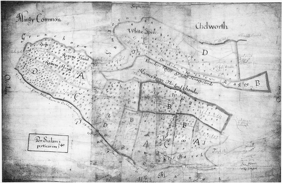
49. Map of Braydon forest, drawn up by the Crown to assist in the process of disafforestation c. 1630.
In 1804 the duchy lands were leased for 30 years to James Cochram, who assigned the remainder of his lease to the earl of Clarendon in 1815. (fn. 789) Clarendon exchanged certain lands with the Crown to acquire ownership of the estate in 1826, and sold it to Joseph Neeld of Grittleton in 1829. (fn. 790) Neeld purchased a total of 1,357 a. divided into eight farms, corresponding to the divisions of Duchy land made under Charles I. His purchase included Duchy rag estate in Cricklade, farms in Purton and lands in other parishes. (fn. 791) In 1884 the Neeld estate consisted of over 3,000 a. in and around Braydon, but in 1901 it was offered for sale and subsequently broken up. (fn. 792) John Edward Ward (d. 1923), bought Red Lodge, and in 1910 he owned 710 a. of land, which included Red Lodge, Pound and Coxhill farms. (fn. 793) He made improvements to tenants' housing on the estate. (fn. 794) His son, Capt H. R. Ward inherited the estate, and in 1942 he had c. 310 a. in hand, Red Lodge and Pound farms. (fn. 795) The rest of the land was leased out, including c. 300 a. to the Forestry Commission. (fn. 796) The estate passed to his daughter Elizabeth Ward, who still owned it in 2010. (fn. 797)
Hatton's (later Red) Lodge
Probably a former hunting
lodge, it incorporates the remains of a 16th-century
building which stood on Langhops hill. (fn. 798) By 1643 Philip
Jacobson had erected a mansion and farm buildings
there, which in 1650 was called Langhops Hill Lodge or
Hatton's Lodge, and later became known as Red Lodge. (fn. 799)
Built of red brick with stone dressings and a stone slate
roof, it was a substantial two-storey house with attics, a
hall, parlour, kitchen, nine chambers and other rooms;
farm buildings included a six-bay barn, stable and
oxstall. (fn. 800) The present two-storey house with garrets
retains one 16th-century two-light window, but the other
front elevation windows were replaced in the early 19th
century when there were internal alterations. There is the
remains of an 18th-century or earlier sub-basement
kitchen. John Edward Ward (d. 1923), who bought the
house in 1902, employed Seddon and Jones, architects,
who greatly enlarged the house in 1910 and (for Ward's
son) in 1927. (fn. 801) Elizabeth Ward divided the house into
three flats and re-named it Hatton's Lodge around 1974. (fn. 802)
She sold it to Robert and Emma Brook in 2007.
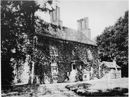
50. Red Lodge c. 1901, originally built in the 16th century, probably as a hunting lodge, greatly enlarged in 1910 and 1927.
White (later Red) Lodge Farmhouse
Built in the 17th
century (although the date stone reads 1806), it was
probably the farmhouse for Jacobson's estate. (fn. 803) It is of
Flemish bond brickwork and was originally built on a
three-room plan with a cross passage, now removed.
Newel staircases at each end leading to usable attics
suggest that the farmhouse was divided into at least two
tenements. The house was altered in the 18th century
when new windows were installed, and a rear out-shut
was added, probably in 1799. Good early features
include a Tudor-arched moulded stone fireplace reused
at first floor, and an early 18th-century two-panel door
on the north ground floor room.
ECONOMIC HISTORY
In the Middle Ages herds of deer grazed in thick woodland, (fn. 804) and before inclosure cattle and sheep could roam freely through the forest. (fn. 805) The tenants of bordering parishes used their common pastures for sheep, but grazed their cattle in the forest, where competition for fodder led to a decline in the number of deer; (fn. 806) and it was claimed that Lord Danvers, a Crown lessee, had killed many trees by lopping and topping them too severely. (fn. 807) By 1613 this exploitation of resources was jeopardising the forest habitat. The Crown aimed to recover lost income by disafforesting Braydon and dividing it into inclosed farmland. The process, begun by Crown lessees c. 1630, proved difficult, as there were few existing boundaries or landmarks and borderers broke down fences and hedges to exercise traditional grazing rights. (fn. 808) A map of 1632 shows the duchy lands, coterminous with Braydon tithing, divided into eight sections; (fn. 809) by 1651 these were being subdivided into fields. (fn. 810)
Three ancient farmsteads are mentioned in 1827: Hatton's Lodge and White Lodge, both originally on Jacobson's estate; (fn. 811) and Maplesale, which was leased to James Duart in 1650. (fn. 812) By 1763 Pack or Park Gate farm had been carved out of the south-east corner of the duchy lands and was leased to John Sherman, lessee of Red Lodge estate. (fn. 813) Commencing in 1805 the Crown made comprehensive improvements to the Braydon estate, (fn. 814) and more farms had been built by 1816 when it was offered for sale. From east to west the eight divisions were under cultivation by Ravensroost farm; (fn. 815) Duchy, later called High Barn farm; (fn. 816) Maplesale farm; (fn. 817) White Lodge farm; (fn. 818) Red Lodge; (fn. 819) Battlelake farm; (fn. 820) Cockshill and Poundhouse farms; (fn. 821) and Parkgate and Roebuck farms. (fn. 822) Considerable investment was made by the subsequent owner, the earl of Clarendon, so that when he offered the estate for sale in 1827 all but the four older farmhouses and most outbuildings had been replaced. (fn. 823)
'Braydon would rot a goose', was a common reflection on its poor, ill-drained land. Although the tenant of Manor farm improved his pasture c. 1865 by installing new drainage systems and applying Peruvian guano and lime phosphate, (fn. 824) it was predicted in 1887 that despite such capital investment Braydon was likely to revert to its former marginal condition, because the land was so poor. (fn. 825) The hamlet's subsequent agricultural history reflects this. In 1879 arable crops grew on only seven per cent of the land. (fn. 826) In 1901 around 25 per cent was covered with woodland plantations for hunting and shooting, and the rest was pasture for cattle and dairy farming. (fn. 827) There were eight farms in 1910. (fn. 828)
In c. 1915 Charles Ernest Godfrey-Jull started a Colonial Training Institute for agricultural students at Gospel Oak Farm, but there is no record of its success. (fn. 829) Rare plants supported a medicinal 'herbing' industry in 1938. (fn. 830) A survey in 1942 identified Braydon's soil as 100% clay and commented on the difficulty of farming the heavy wet land. The 'very poorest type of Braydon land' lay in the marshy eastern third of the parish. Despite the pressure of food shortages, it was only possible to grow a few acres of arable crops on the better land. (fn. 831) In the later 20th century the woods were mainly in the hands of the Forestry Commission. Ravensroost wood and meadows were purchased in 1987 and 1999 respectively by the Wiltshire Wildlife Trust, and with Avis meadow (in Charlton) form one of the trust's largest nature reserves, comprising semi-natural woodland and traditionally managed hay meadows. (fn. 832)
SOCIAL HISTORY
Education
A National school with house for
schoolmistress was built at Braydon in 1857/8 for 36
pupils, and enlarged in 1882 to accommodate 60; but
numbers were always low and it was closed in 1933. (fn. 833)
Public services and utilities
In 1639 the Crown
granted Philip Jacobson exemption from paying taxes
and Braydon's inhabitants subsequently claimed they
were exempt from paying poor rates. In 1705
Cricklade's parish officers, who were supporting
Braydon's poor, brought a court case against Purton's
parish officers, who were then obliged to take
responsibility for poor squatters in Braydon. (fn. 834) In 1813,
Braydon poor rate raised £191, which supported 36
people on permanent relief and provided occasional
relief for six more. (fn. 835) Braydon was included in Cricklade
and Wotton Bassett Poor Law Union, formed in 1835, (fn. 836)
and became a civil parish in 1866. It fell under the
authority of Cricklade and Wootton Bassett Rural
Sanitary District (Rural District Council from 1894)
from its formation in 1872 until 1974, when the rural
district council became part of North Wiltshire District
Council, which was abolished in 2009. (fn. 837)
LOCAL GOVERNMENT
Forest law was enforced in Braydon in the 12th century, and the men of Purton were among those summoned to attend forest inquisitions in the mid 13th century. (fn. 838) Regards were held in Braydon preparatory to the forest eyres. Swanimote rolls for Braydon, are extant for the years 1595 and 1610–23; the courts were held annually under the supervision of two verderers, and were attended by those with common pasture rights in the forest. Purton manorial custom governed the appointment of court officials, inheritance, and grazing and timber rights in Braydon forest in the decades around 1600. (fn. 839)
RELIGIOUS LIFE
Established Church
The former tithing and
successor civil parish have always fallen within Purton
ecclesiastical parish. Braydon had curates in the 19th
century and was served as curate by Digby Octavius
Coates (d. 1879) for 28 years. Largely due to his efforts a
chapel of ease was built at the Firs in 1868. (fn. 840) The chapel
regularly attracted congregations of c. 100. Following
his death his widow had the church moved to a new site
on the Wootton Bassett to Ashton Keynes road. Albert
Horatio Dunn (d. 1928), a lay reader, led services there
for 30 years, followed by Capt Ward of Red Lodge.
Canon Willis celebrated Holy Communion once a
week, a Sunday school was attended by c. 20 children
and social events were held in the school. From 1954 the
vicar came only once a month and the congregation
shrank to six. In 1970 the church was closed and its
monuments transferred to Purton church. In 1980 it
was sold and converted into a private house. (fn. 841) In 1869,
John Elton Mervyn Prower (1811–82), son of the vicar of
Purton, gave a chalice dating from 1759 and a paten
dating from 1719. (fn. 842)
Nonconformity
A small Primitive Methodist
chapel of corrugated iron was built to serve Braydon in
1889, and remains in regular use as Braydon Methodist
church. It stands near Moonleaze farm in Purton
parish. (fn. 843)
51. The Primitive Methodist chapel built from corrugated iron in 1889, and still in regular use.