A History of the County of Stafford: Volume 9, Burton-Upon-Trent. Originally published by Victoria County History, London, 2003.
This free content was digitised by double rekeying. All rights reserved.
'Introduction', in A History of the County of Stafford: Volume 9, Burton-Upon-Trent, ed. Nigel J Tringham (London, 2003), British History Online https://prod.british-history.ac.uk/vch/staffs/vol9/pp1-2 [accessed 24 April 2025].
'Introduction', in A History of the County of Stafford: Volume 9, Burton-Upon-Trent. Edited by Nigel J Tringham (London, 2003), British History Online, accessed April 24, 2025, https://prod.british-history.ac.uk/vch/staffs/vol9/pp1-2.
"Introduction". A History of the County of Stafford: Volume 9, Burton-Upon-Trent. Ed. Nigel J Tringham (London, 2003), British History Online. Web. 24 April 2025. https://prod.british-history.ac.uk/vch/staffs/vol9/pp1-2.
Introduction
THIS VOLUME covers the ancient parish of Burton-upon-Trent, lying on the river Trent which forms the county's eastern boundary with Derbyshire. (fn. 1) The article on Burton town comprises sections on its general history arranged chronologically, followed by sections on specific topics. Then come articles on the villages in the extensive medieval parish (namely Branston, Horninglow, Stretton, and Winshill), together with an article on Stapenhill, which was originally a township in the Derbyshire parish of the same name but which was added to the municipal borough in the late 19th century. In the Staffordshire hundred of Offlow, Burton became a municipal borough in 1878 and a county borough in 1901, but since 1974 it has been in East Staffordshire district. The surrounding rural area was in Tutbury rural district until 1974.
The river Trent forms a broad flood plain as it flows north through the area, especially on its west side before the land begins to rise steeply up to the Needwood plateau. There are a number of significant archaeological sites on the river terraces in the Burton area, notably a late Neolithic or early Bronze Age settlement near Catholme Farm, in Barton-under-Needwood, and many of the cropmarks which have been detected in that area may represent farming activities in the Iron Age or Roman period. The Roman Ryknild Street running from Wall (near Lichfield) to Derby, took a line west of the later settlement at Burton, crossing the river Dove in Stretton.
Burton came to prominence in late Anglo-Saxon period as the site of a Benedictine abbey, itself almost certainly the successor to a 7th-century minster church which came to be associated with the legendary St. Modwen. It became a borough in the Middle Ages, but the burgesses failed to develop powers of self-government and the town continued to be governed by the abbey. Besides having a market and fairs, Burton was also a clothworking town with fulling mills on the river, and there was an important alabaster industry with carvers and painters working alabaster from Tutbury. Although fulling cloth was abandoned from the mid 17th century, Burton retained a textile trade in the form of felt- and hat-making, which remained important until the early 19th century. In the late 18th century the river Trent was harnassed to power cotton mills, but they ceased to operate in the 1840s.
Important factors in the development of Burton's economy were the effective navigation of the Trent in the first decade of the 18th century and its connexion to the Trent and Mersey canal in the 1770s. Improved communications stimulated a new metalworking industry with water-powered forges at Burton and on the Dove at Stretton, and they also promoted longdistance trade in which brewer-merchants combined the export of ale and the import of timber. The opening of a railway line through Burton in 1839 enabled local brewers to break into the export market of pale ale to India, and their success laid the foundations for Burton's transformation into a predominantly one-industry town. The overwhelming impact of brewing was moderated by a significant engineering side to Burton's economy, and that remained important as brewing declined in the late 20th century. In recent years Burton has also attracted new businesses, taking advantage of its position near the intersection of the A38 and A50, two major roads running respectively north-south and east-west and with links to the motorway system.
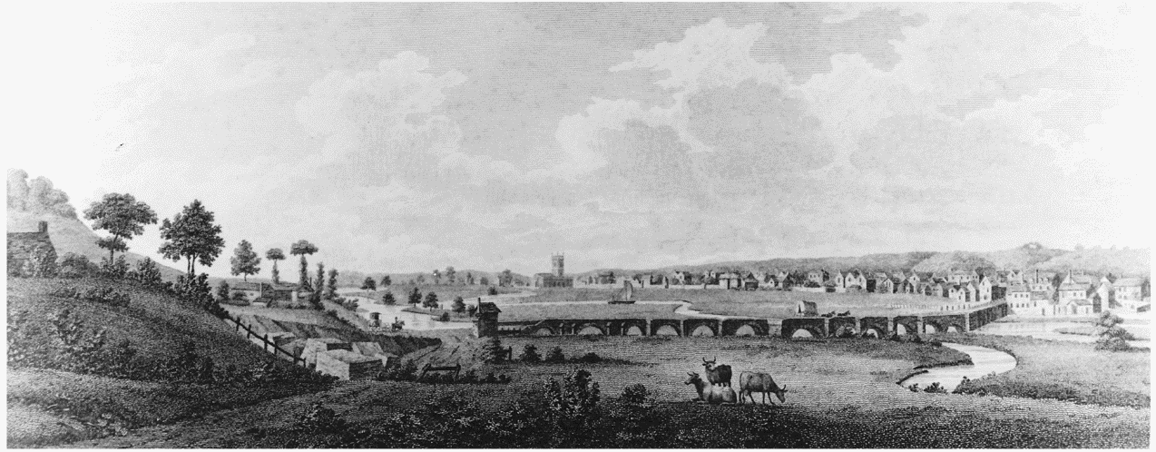
Burton from the north in 1779
Visually Burton is outstanding for its late Victorian town hall and suburban Anglican churches. Parts of the town centre were built up with breweries in the 19th century and little remains of earlier buildings, although a few houses in High Street and Horninglow Street retain medieval fabric. Two medieval buildings (the present Abbey inn and Manor House) also survive in the former monastic precinct. The demolition of many of the town-centre breweries in the late 20th century opened up sites for commercial development, notably shopping centres.
Of Burton's outlying agricultural villages, Branston was significant for a hunting ground called Sinai park, where the abbey had a rest-house which survives on a moated site. During the 19th century Horninglow, Stapenhill, and Winshill were brought into the municipal borough, chiefly as areas for middle- and working-class housing. All three places were included in the county borough created in 1901, with Branston and Stretton remaining outside as their own civil parishes. After the Second World War large council-house estates were laid out in Stapenhill and Winshill, whereas most of the later privately-built housing estates are in Branston and Stretton.