A History of the County of Lancaster: Volume 8. Originally published by Victoria County History, London, 1914.
This free content was digitised by double rekeying. All rights reserved.
'Townships: Hawkshead and Monks Coniston', in A History of the County of Lancaster: Volume 8, ed. William Farrer, J Brownbill (London, 1914), British History Online https://prod.british-history.ac.uk/vch/lancs/vol8/pp376-380 [accessed 19 April 2025].
'Townships: Hawkshead and Monks Coniston', in A History of the County of Lancaster: Volume 8. Edited by William Farrer, J Brownbill (London, 1914), British History Online, accessed April 19, 2025, https://prod.british-history.ac.uk/vch/lancs/vol8/pp376-380.
"Townships: Hawkshead and Monks Coniston". A History of the County of Lancaster: Volume 8. Ed. William Farrer, J Brownbill (London, 1914), British History Online. Web. 19 April 2025. https://prod.british-history.ac.uk/vch/lancs/vol8/pp376-380.
In this section
HAWKSHEAD AND MONK CONISTON WITH SKELWITH
Houkesete, c. 1200; Hawshead, 1336.
Kunyngston, 1336.
This composite township, with a total area of 10,429 acres, has four divisions—Hawkshead, Fieldhead, Monk Coniston and Skelwith. Hawkshead, 1,972½ acres, lies on the west side of Esthwaite Water; the greater part of it is the hill country called Hawkshead Moor, but there is some more level ground beside the lake and also in the vale at the north end of the lake. In this sheltered vale, on rising ground, the little town of Hawkshead is built, the church being a prominent feature. The old schoolhouse adjoins it, but is lower down. Fieldhead, 2,519½ acres, is to the north of Hawkshead; it contains the vale extending north from Esthwaite Water, with the hills on each side, in one place rising to 1,056 ft. above the sea, and another valley to the east, in which is Blelham Tarn, discharging into Windermere. Monk Coniston, 3,109 acres, lies to the west, being bounded by Yewdale Beck and Coniston Water, into which it flows. It has two hill ranges, one at the head and the other by the side of Coniston Water, rising to 800 ft. and 922 ft. respectively. The scenery in this part is fine; Tarn Hows, on the border of Monk Coniston and Fieldhead, is formed artificially from several small tarns, and adds much to the beauty of the district. (fn. 1) Skelwith, 2,828 acres, occupies the north end of the township, the hills there descending to the River Brathay, which flows east to Windermere. On this river is the waterfall called Skelwith Force. The population in 1901 numbered 1,126. (fn. 2)
The roads are mainly determined by the physical features. One road from the ferry at Windermere enters the township at the south end of Esthwaite and goes along the west side to Hawkshead town, receiving one road from over the hills to the west and another from Windermere on the east. After passing through the town it goes by Gallowbarrow (fn. 3) and divides at Hawkshead Hall; one branch goes north by Birkwray and Outgate to Skelwith and Ambleside, while the other turns west, passing the old Baptist chapel and going over the hill to Waterhead and Coniston. This branch has offshoots north past Borwick Lodge to Skelwith, and south along the eastern shore of Coniston Water, past Brantwood, towards Ulverston. There is no railway line, but the roads are busy in the summer time with the coaches and cars carrying visitors through this part of the Lake district.
The main, almost the only, industry is agriculture, but there are slate quarries on the western boundary. The wool market at Hawkshead is extinct; a bobbin factory at Thursgill stopped owing to the bursting of a dam and was not restarted; and nothing remains of a charcoal iron forge beside Blelham Tarn. (fn. 4)
A heel-marked stone in Yewdale Beck had a story of witchcraft attached to it, the depression being known as 'the devil's foot-mark.' (fn. 5)
A mock manor court was formerly held at Outgate. (fn. 6)
In the town of Hawkshead is an institute, with library and reading-room.
The soil is light over stony subsoil. The land is mostly in grass.
In 1894. Monk Coniston was cut off from this township and added to Church Coniston, Skelwith being also cut off and constituted an independent township. The remainder is the present Hawkshead township. (fn. 7)
Manor
After the partition made about 1160 between the monks of Furness and William de Lancaster, by which the former received the Hawkshead and Colton part of the Fells, (fn. 8) they established a manor-house at HAWKSHEAD and from it ruled the district. (fn. 9) After the Suppression this manor was retained by the Crown until 1666, when it was granted, like the liberty of Furness, to the Duke of Albemarle, (fn. 10) and has since descended in the same way. The grant included the rents from tenements held by the ancient custom called 'tenant right,' from Blelham tarn fishery, Elterwater Park, and the bailiwicks of Brathay, Skelwith, Arnside, Oxenfell, Waterhead and (Monk) Coniston, with other profits.
According to the Survey of 1649 only one court was then held in the Fells, viz. a court leet at Hawkshead in October; the manor was reputed to be a member of the manor of Furness, and the bailiwick of Hawkshead, held by William Sawrey, extended over Hill Hawkshead, Robert and Water Park. (fn. 11) A pleading of 1584 gives information as to some of the customs of the manor; it followed the suppression of the smithies and related to fresh inclosures by Christopher Sandys and others. It was stated that tenements in the lordship had always had land called 'inground,' inclosed and kept in severalty with hedge and ditch; also barren heath and rocky stone ground called 'pasture ground,' much still uninclosed, for the cattle of customary tenants. This pasture land was bounded as to how much belonged to each township or hamlet, and it was known how much wood and underwood growing there each tenant ought to have for feeding cattle, and also by bounds how much of the woodland and pasture belonged to each tenant. (fn. 12)
The customs of the Fells, as settled in 1586, (fn. 13) remain almost intact, and courts are regularly held. (fn. 14) The common field extended south from the town along the bank of Esthwaite Water. (fn. 15)
An inquiry into waste of the king's woods in Hawkshead and High Furness was made in 1662. (fn. 16)
The occupiers of the land were formerly of the statesman or yeoman class, customary freeholders of the manor. (fn. 17) 'Gavelkind' tenure is mentioned at Waterhead in 1 566, (fn. 18) but this is probably a misdescription. Among the more noteworthy families arising after the suppression of the abbey was that of Sandys of Esthwaite, (fn. 19) still represented at Graythwaite. They are stated to have originated near St. Bees in Cumberland. The first of them in Hawkshead of whom anything definite is known was William Sandys, receivergeneral of the liberties of Furness, (fn. 20) who died about 1558; he and Margaret his wife have a tomb in the church with their effigies upon it, as described above. (fn. 21) Esthwaite Hall, now an uninteresting looking farmhouse, has been partly demolished and its original plan is untraceable. (fn. 22)

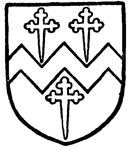
Sandys. Argent a fesse dancetty between three crosslets fitchy gules.
HAWKSHEAD HALL, the old manor-house of the Furness monks, was sold to Edward Ditchfield and others in 1628. (fn. 23) It had from 1582 been held on lease by a family named Nicholson, who probably purchased from the patentees. (fn. 24) Nathaniel Nicholson was in 1631 called upon to pay £10 for having refused knighthood. (fn. 25) In the Civil War he took the side of the Parliament. (fn. 26) In 1687 there was a dispute as to suit to Hawkshead Mill between John Copley and Beatrice his wife on one side and Edward Braithwaite on the other. The plaintiffs stated that Nathaniel Nicholson had left a son Daniel, whose heirs were his daughters Beatrice above-named and Judith wife of George Carus. (fn. 27) Judith sold her right to her sister, whose grandson, the Rev. John Copley, sold the estate in 1756 to Samuel Irton; his son sold it in 1792 to William Fell of Ulverston, and his son in 1860 sold it to the late James Swainson CowperEssex, whose trustees are now in possession. (fn. 28)
The hall, (fn. 29) which is now a farm-house, stands about half a mile to the north of the village near the junction of the main roads from Ambleside and Coniston close to a stream called the Hall Beck, which flows past the house on its west and south sides. On the north the site is sheltered by higher ground, now a rookery. The building seems to have been originally quadrangular, though the north side may have been open or inclosed by a wall, but only two detached portions—the east wing or gate-house and part of the west wing—now remain. The three sides of the quadrangle were standing down to about the year 1870, when, or shortly after, the south wing, which contained the hall and parlour, was destroyed. The house was. with the exception of the gatehouse, probably built by the Nicholsons, though there is evidence that they incorporated some older work in the new building. The gate-house is of 15th-century date, but it contains a fireplace in the upper floor with dog-tooth ornament round the edge of the opening, which has given rise to much speculation as to whether the structure may not be a rebuilding of the 13th-century manor-house erected by the monks of Furness. Whether the fireplace is in its original position, however, it is impossible to say, but the probability seems to be that it is a fragment of an earlier building used up at a much later date.

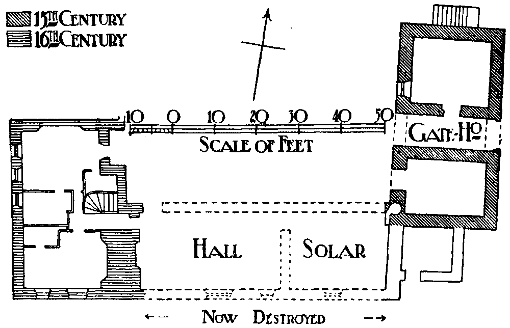
Plan of Hawkshead Hall
The destroyed south wing was 59 ft. 4 in. in length by 23 ft. 6 in. in width, and was probably originally coeval with the gate-house, though reconstructed by the Nicholsons. Sufficient evidence, however, no longer remains for any positive statement regarding it, as long before its destruction it had become, together with the portion of the west wing now remaining, almost entirely modernized. It is described as having been a 'perfectly plain' roughcast building of two stories, with square late windows and externally of no architectural interest. The hall, which occupied its full width, was at the west end and measured internally about 34 ft. by 19 ft. with a large solar, or parlour, at the east end. The kitchen and offices were in the west wing, the kitchen separated from the hall by a wall 9 ft. thick containing the hall and kitchen fireplaces back to back. This wall, which still remains as the outside wall of the farm-house, is probably of 16th-century date, the original arrangement of the hall, which would be modified at that time, having most likely been that of a screen passage at the west end with the dais at the east. The west wing, or the portion of it now remaining, is about 43 ft. in length by 30 ft. in width, but was probably originally continued further north. It has two rooms on the ground floor and there is a massive oak staircase to the upper floor, but externally it is modernized and of little interest except for its cylindrical chimneys. The masonry is of the roughest rubble formed of boulders and cobbles with sandstone dressings.
At its north-east corner the destroyed south wing fitted with its north-east angle against the southwest angle of the gate-house, but the two buildings were not bonded together, and all through the gatehouse there is a want of bond in the walls, so that it is difficult to state positively whether the gate-house was built on to the original south wing or vice versa. The gate-house itself is an interesting rectangular twostory structure measuring externally 47 ft. long by 26 ft. wide, with a stepped gable at each end north and south, the east or principal front standing back about 35 yds. from the road. The walls are of rubble masonry with red sandstone dressings, but the roof is covered with modern slates and the building has been otherwise restored. The gateway is 8 ft. wide and not quite centrally placed, (fn. 30) with a fourcentred straight-sided arch on the east side 9 ft. in height, of dressed sandstone with a sculptured keystone, (fn. 31) over which is a lion's head, and over this again a trefoil-headed niche which until 1834 contained a seated figure of the Virgin. On each side of the passage is a room entered from the courtyard, (fn. 32) both now used as stables, that on the south, which is the smaller and has an original slit window 5 in. wide facing east, being probably the porter's lodge. The gate-house may have been built for holding the manor court and is sometimes called the courthouse. The court was held in the upper story, which consists of a single room 40 ft. long by 19 ft. 9 in. wide, access to which is gained by an external staircase at the north end. It was originally lighted on each side by two square-headed windows each of two trefoiled lights and a larger pointed one at the south end of two cinquefoiled lights with tracery in the head. (fn. 33) This window with those on the east side remain, but the two facing the courtyard have been built up and a modern window inserted immediately above the arch, which on this side has a plain segmental head. One of the windows on the east side has, however, been entirely renewed in red sandstone and the other has been repaired. The doorway at the north end of the court-room is a modern one 5 ft. in width, and the roof is an open one of four bays with plain collared principals plastered between the spars. In the middle of the east wall is the fireplace (fn. 34) with dog-tooth ornament already mentioned, but there is no sign of a chimney on the outside, the modern roof being carried over the walls with overhanging eaves. There is some evidence that at the south end of the court room, which is now used as a hayloft, there was a dais, and that in the angle where the buildings joined a spiral staircase was constructed. Part of the east wall of the destroyed south wing still stands and the angle between it and the gate-house is now occupied by a modern onestory building with lean-to roof erected against the south wall of the latter.
MONK CONISTON HALL was in the 18th century owned by a family named Ford. William Ford had two daughters—(1) Catherine, who inherited Monk Coniston and married George Knott, and their representatives sold to James Garth Marshall, sometime M.P. for Leeds; (2) Agnes, who had Ford Lodge in Grizedale, and married Henry Ainslie, M.D. (fn. 35) Lawson Park, a herdwick in Monk Coniston, was sold by the Crown in 1625. (fn. 36) Brathay was called a manor in 1564. (fn. 37) Near Hawkshead Hall is High House, formerly the homestead of the Swainsons, but rebuilt by the grandfather of its present owner, Mr. Henry Swainson Cowper, whose history of the parish is frequently cited in the present account. (fn. 38)
In 1606 a charter was obtained for a market every Monday and fairs on St. Matthew's Day and the Ascension. (fn. 39) After the change of style the former was kept on 2 October; the latter was also altered, being held on the Monday before the feast. Two others grew up by custom, on Easter Monday and Whit Monday. These were all well frequented in the first half of last century, but the market has long been discontinued, and the fairs have ceased to be of any importance. (fn. 40) The town hall or market hall was built in 1790 on the site of the older Market Shambles or Butcher-house, (fn. 41) and has been enlarged.

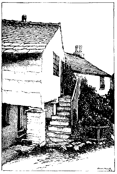
Pillared House, Hawkshead
The parish church has been described above. In Skelwith is Brathay Church, Holy Trinity, built in 1836 (fn. 42); the patronage is vested in trustees.
The Particular Baptists have long had a chapel at Hawkshead Hill (fn. 43), it was probably formed out of an existing cottage. The cause was founded at Torver in 1678, but Hawkshead seems to have become the chief meeting-place soon afterwards, its endowment dating from 1707. It is mentioned by Bishop Gastrell in 1717. The cause became extinct in 1833, but has been revived, so that there are now a few members. The burial-ground is still used. (fn. 44)
There is a Nonconformist chapel in the town.
The Society of Friends almost at its commencement found members at Hawkshead, for in 1659 Agnes Rigg was buried at Colthouse in Claife in the new Quaker ground. (fn. 45) In 1689 three meeting-houses were registered in the parish, viz. that at Colthouse, another at Stang End, and a third at Spooner Close. (fn. 46) The first is the only one now in use.