A History of the County of Lancaster: Volume 4. Originally published by Victoria County History, London, 1911.
This free content was digitised by double rekeying. All rights reserved.
'Townships: Golborne', in A History of the County of Lancaster: Volume 4, ed. William Farrer, J Brownbill (London, 1911), British History Online https://prod.british-history.ac.uk/vch/lancs/vol4/pp148-150 [accessed 19 April 2025].
'Townships: Golborne', in A History of the County of Lancaster: Volume 4. Edited by William Farrer, J Brownbill (London, 1911), British History Online, accessed April 19, 2025, https://prod.british-history.ac.uk/vch/lancs/vol4/pp148-150.
"Townships: Golborne". A History of the County of Lancaster: Volume 4. Ed. William Farrer, J Brownbill (London, 1911), British History Online. Web. 19 April 2025. https://prod.british-history.ac.uk/vch/lancs/vol4/pp148-150.
In this section
GOLBORNE
Goldeburn, 1187; Goldburc, 1201; Goseburn (? Goleburn), 1202; Goldburn, 1212; Golburne, 1242. The d seems to have dropped out finally in the 15th century; Golborne, Gowborne, xvi cent.
This township stretches northwards for about 2½ miles from the boundary of Newton to the Glazebrook. Millingford Brook, coming from Ashton, crosses the township and afterwards forms part of the eastern and southern boundaries. The area is 1,679 acres. (fn. 1) The surface is highest near the centre, reaching about 150 ft. The population in 1901 numbered 6,789.
There is land sufficiently fertile to produce potato and wheat crops, whilst in the south there are clumps of woodland about Golborne Park, continuing all along the western boundary, so that from these quarters Golborne appears to be bowered in foliage. In the north, however, the country presents the characteristic bareness of the other coal-mining districts of the hundred. The Pebble Beds of the Bunter series of the New Red Sandstone cover the entire surface of the township.
The village of Golborne is near the centre of the township, on the north side of the brook. A road from Warrington to Wigan passes through it, and is there joined by another from Newton; there are also cross-roads between Ashton and Lowton. The London and North Western Company's main line from London to the north passes through the township, and has a station at Golborne; at the southern end is a junction with the loop-line connecting with the Liverpool and Manchester Railway. The St. Helens and South Lancashire Railway (Great Central) crosses the northern part of the township, and has a station called Golborne.
Lightshaw is at the northern extremity; Edge Green on the Ashton boundary, and Golborne Park, a seat of the Legh family, at the southern end.
Cotton-spinning and fustian-making were carried on early last century. There are now cotton-mills, a paper-staining factory and a colliery. A 'glass man' named Hugh Wright appears on the Recusant Roll of 1626. (fn. 2)
Some interesting field-names occur in a suit of 1553, e.g. Pillocroft, Bromburhey, Pennybutts, and Parpount hey. (fn. 3)
Golborne is now governed by an urban district council of twelve members.
MANORS
At the inquest of 1212 it appears that GOLBORNE was held of the baron of Makerfield in moieties; one half was held by the lord of Lowton, the other by a family using the local surname. (fn. 4) As in the case of Lowton itself the former moiety reverted to the lords of Makerfield, and no one else claimed any manor there. (fn. 5) In the latter moiety there may have been a failure of heirs, and a new grant in socage to the Hollands; but one heiress of the Golbornes (fn. 6) appears to have sold her right to Thurstan de Holland, (fn. 7) whose descendants continued to be regarded as its lords. (fn. 8)
Thurstan, however, granted all or most of his moiety to his son Simon, (fn. 9) whose descendant Amice carried the manor of LIGHTSHAW in marriage to Nicholas de Tyldesley. (fn. 10) From this family by another heiress, it passed to the Kighleys of Inskip, (fn. 11) and from these again at the end of the 16th century, to William Cavendish, first Earl of Devonshire, and Thomas Worsley, in right of their wives, the Kighley coheirs. (fn. 12) The former of these secured it, and it descended in the Cavendish family for over a century, (fn. 13) but there is no further mention of Lightshaw as a manor. The estate was purchased by Peter Legh of Lyme in 1738 from the Duke of Devonshire, and is now the property of Lord Newton. (fn. 14)
The Hospitallers had lands here. (fn. 15) Cockersand Abbey had a tenement called Medewall, (fn. 16) for which the free tenants, a family named Langton, paid a rent of 2s. 6d. (fn. 17)
The Hoghtons of Hoghton were landowners in Golborne from an early date, (fn. 18) and the Haydocks also, (fn. 19) with other of the neighbouring families. (fn. 20) Elizabeth Kighley and Ralph Haselhurst were the landowners contributing to the subsidy in Mary's reign; (fn. 21) Edward Bankes was the only freeholder recorded in 1600. (fn. 22) The Pierpoint family occur in Golborne and the neighbourhood from an early time. (fn. 23) Henry Pierpoint died in or before 1642 holding land here; (fn. 24) and another of the same name in 1654 petitioned the Parliamentary Commissioners for the discharge of the two-thirds of his inheritance sequestered in 1643 for the recusancy of his father Richard, deceased; he himself was 'conformable.' (fn. 25)

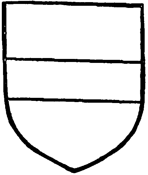
Kighley of Inskip. Argent a fesse sable.

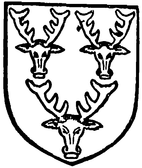
Cavendish, Duke of Devonshire. Sable three bucks' heads cabossed argent.
The Inclosure Award for Golborne Heath, with plan, is preserved at the County Council Offices, Preston.
For the Established Church St. Thomas's was built in 1850; the benefice is a rectory, in the patronage of the Earl of Derby.
The Primitive Methodists have a chapel. The Baptists began a meeting in 1894.
The Congregationalists have a church originating in occasional visits from preachers in 1821 onwards; a chapel, still existing in part, was built in 1830, replaced by the present one in 1860. (fn. 26) The Welsh Congregationalists also had a place of worship.
For Roman Catholic worship (fn. 27) the church of All Saints was erected in 1863. (fn. 28)