A History of the County of Lancaster: Volume 3. Originally published by Victoria County History, London, 1907.
This free content was digitised by double rekeying. All rights reserved.
'Townships: Litherland', in A History of the County of Lancaster: Volume 3, ed. William Farrer, J Brownbill (London, 1907), British History Online https://prod.british-history.ac.uk/vch/lancs/vol3/pp95-98 [accessed 19 April 2025].
'Townships: Litherland', in A History of the County of Lancaster: Volume 3. Edited by William Farrer, J Brownbill (London, 1907), British History Online, accessed April 19, 2025, https://prod.british-history.ac.uk/vch/lancs/vol3/pp95-98.
"Townships: Litherland". A History of the County of Lancaster: Volume 3. Ed. William Farrer, J Brownbill (London, 1907), British History Online. Web. 19 April 2025. https://prod.british-history.ac.uk/vch/lancs/vol3/pp95-98.
In this section
LITHERLAND
Liderlant, Dom. Bk.; Litherland, 1212. Generally Down Litherland.
Litherland forms an uninteresting link between the busy environs of Bootle and the more open country towards Sefton township, since there are both dwelling-houses and warehouses, streets, and shops, as well as open spaces. It lies on a slightly higher level than its seaward neighbour, Seaforth. The soil is for the most part sandy, with a subsoil of clay. The geological formation of the north-eastern half of the township consists of lower keuper sandstones of the new red sandstone or triassic formation; that of the south-western of the waterstones of the same series. The strata are concealed by alluvial deposits along the course of the Rimrose Brook, and by a broad stretch of blown sand adjoining the coast. The ancient township, from which Seaforth has now been carved out, contains 1,205 acres. (fn. 1) It was formerly called Down Litherland to distinguish it from the hamlet of Up-Litherland in Aughton. The roads from Liverpool to Southport, and to Sefton and Ormskirk, were the principal ones, but the township has become a residential district with numerous roads and streets. The Lancashire and Yorkshire Railway Company has a station at Seaforth on its Southport line, and the Fazakerley branch of the same company passes through the township. The Leeds and Liverpool Canal also passes through it.
The population in 1901 numbered 10,592, while that of Seaforth was 13,263.
The Diamond Match Factory is the most prominent industry in Litherland.
The field names in a map of 1769 (fn. 2) show that the Marsh was the district between Rimrose Brook and the shore; the Bullcroft was here. East of the present Seaforth Station was the Holme, and to the north Such Field and Whabs. The moss occupied the north-eastern part of the township; the moor adjoined it on the borders of Orrell. The Church Field was north of the old village, on the borders of Ford; the reason for this name, an ancient one, is unknown. Aynard Hey was a strip lying between the village and Church Field.
A local board was formed in 1863 for the part not in the Waterloo-with-Seaforth district (fn. 3); in 1894 this part was constituted the township of Litherland; it is governed by an urban district council of twelve members.
MANOR
At the death of Edward the Confessor Elmaer held LITHERLAND for a manor assessed at half a hide, or three plough-lands, and its value beyond the customary rent was the normal 8s. (fn. 4) Within sixty years the whole had come into the possession of the Molyneux family, and has since descended with Sefton. It was, however, acquired in moieties by different titles. One moiety is supposed to have been part of the original Sefton fee; the other was granted in exchange for Toxteth, and for this part a thegnage rent of 20s. was paid, the undertenants in 1212 being Robert de Walton and Richard son of Siward, each holding one-half. (fn. 5) About the year 1125 Stephen, count of Boulogne and Mortain, had assured to Robert de Molyneux and his heir his land in Litherland for 14s. a year—apparently the thegnage moiety. (fn. 6) In 1324 the two portions are clearly distinguished, Richard de Molyneux holding one half by the service of 20s., and the other half in conjunction with Sefton. (fn. 7)
It thus appears that from an early time Litherland was divided into a half and two quarters; and this is perhaps the origin of the modern division into Litherland, Orrell, and Ford.

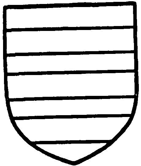
Lea of French Lea. Sable, three bars argent.
One of the two quarters at least was probably held by a 'Demand,' a doom-man or judge, so called from the hereditary service discharged in the wapentake court as the representative of the lord of Sefton. There were two families bearing the surname Demand, one of which was certainly connected very closely with Orrell. The quarter of the manor held by the latter family cannot be traced with clearness, but appears to have been held by one Siward about 1200 (fn. 8) and to have descended to the Demand family, (fn. 9) being sold in 1335 by Richard the Demand to Peter, a younger son of Richard de Molyneux of Sefton. (fn. 10) With the latter's daughter it went to John Dandyson of Ditton, (fn. 11) and was purchased from Richard and Peter de Ditton by Sir Richard Molyneux and his son in the latter part of Henry VI's reign. (fn. 12)

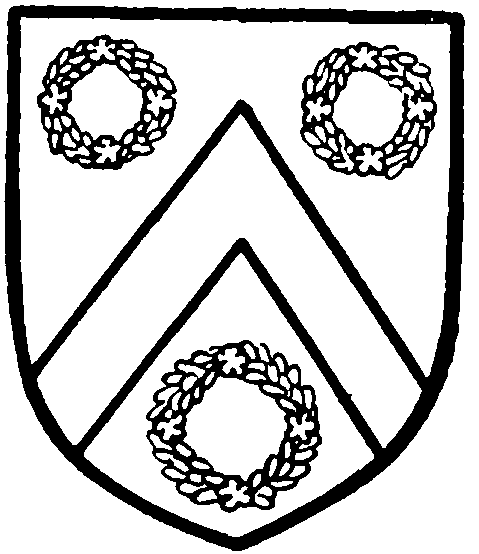
Ashton of Croston. Argent, a chevron between three chaplets gules.
The other quarter came into possession of the Lea or Lee family, (fn. 13) and descended with other of their lands to the Ashtons of Croston, (fn. 14) until alienated in 1596 by Thomas Ashton, who sold his fourth part of the manor, with all his lands in Litherland, Orrell, and Ford, to Sir Richard Molyneux. (fn. 15) There was another family named Lee in the township whose property also came to Molyneux. (fn. 16)
Richard de Molyneux had before 1212 given two oxgangs of land to Randle de Litherland by knight's service and a rent of 5s. (fn. 17) A family bearing the local name appears from time to time. (fn. 18)
Among the other holders of land in the fifteenth century and earlier may be named the families of Ballard, (fn. 19) Gorstihill, (fn. 20) Linacre, (fn. 21) Makin, (fn. 22) Mercer, (fn. 23) Tristram, (fn. 24) and Witlaw. (fn. 25) The Moores of Bank Hall acquired a considerable holding in the township, chiefly, it would seem, by purchase from some of the earlier owners just named. (fn. 26) In 1628 the only freeholders mentioned were the heirs of Richard Davy. (fn. 27) The recusant roll of 1641 groups the three Litherland townships with Aintree, and records only six names; Henry Bootle was probably of this township. (fn. 28) In 1769 besides Lord Molyneux, the earl of Derby, William Bolton, Richard Tristram, John Wainwright, and others held small portions of the land. (fn. 29)
For members of the Established Church St. Philip's was built in 1863. (fn. 30) Trustees have the patronage. St. Mark's is a chapel of ease. St. Andrew's, originating in the same way, has now an independent district; the bishop of Liverpool is patron.
There is a Wesleyan chapel in Litherland village.
WATERLOO
WATERLOO stands on the margin of the Mersey estuary, healthily situated, with a wide breezy prospect, although the surface of the land could scarcely be flatter. In this respect it is precisely like its neighbours north and south. Nearly one-half of the township is covered by the sea at high-water, for the boundaries extend far into the estuary, whilst at low tide there is a broad stretch of firm sands beyond the houses and terraces which face the sea. The rest of the land is occupied by the town of Waterloo, which may be looked upon as an important residential suburb of Liverpool, reached in a few minutes by the electric railway.
The hamlet of Crosby Sea-bank grew at the beginning of last century into a 'flourishing sea-bathing place.' (fn. 31) The Waterloo Hotel, traditionally said to have been commenced on the day the famous battle was fought, gave a distinctive name to the place. (fn. 32) The first railway was that from Southport, opened in 1848, the terminus being for a time at Waterloo; passengers were carried by coach to and from Liverpool. (fn. 33) The local government district of Waterloowith-Seaforth was formed out of Litherland in 1863, (fn. 34) and in 1874 extended to include part of Great Crosby. (fn. 35) In 1894 the separate townships of Waterloo and Seaforth were created and joined to make the urban district of Waterloo-with-Seaforth. (fn. 36) The council has eighteen members. The Town Hall was built in 1862.
In connexion with the Established Church there are Christ Church in the Litherland portion, built in 1839, several times enlarged, and rebuilt in 1892; (fn. 37) St. John's Church in the Great Crosby portion, built in 1865; (fn. 38) and St. Mary's Church, built in 1877, and consecrated in 1886. The patronage of these churches is vested in different bodies of trustees.
The English Presbyterian church of St. Andrew was built in 1876, a congregation having been gathered about three years earlier. There are a Wesleyan church and a temporary Baptist chapel. The Congregational church, opened in 1866, is the result of services begun in 1855 by the Rev. T. Sleigh, formerly of Wavertree. (fn. 39) The Salvation Army has barracks in East Street.
The Roman Catholic church of St. Thomas of Canterbury, on the Litherland side of the boundary, was opened in August 1877; a temporary chapel had been used from 1868. (fn. 40)
SEAFORTH
SEAFORTH township was formed in 1894 from Litherland, and joined with Waterloo to form an urban district. (fn. 41) The two occupy the whole river frontage of Litherland and part of that of Great Crosby. The name is derived from Seaforth House, which Sir John Gladstone built about 1815. When the tide is low a broad stretch of sands is uncovered and forms a favourite recreation ground of the inhabitants of Liverpool, since these sands are on the north side the nearest to the city, approached easily by the overhead electric railway. The rest of the township is thickly populated. The streets are level on a sandy soil, the town being built upon land once occupied by sandhills.
There are large barracks at Seaforth.
The shore has been secured by the Mersey Dock Board.
The Established Church had the first place of worship here, St. Thomas's, built in 1815 by Sir John Gladstone, and recently enlarged. The Rev. S. E. Gladstone is patron.
The Congregationalists have a school-chapel, built in 1881 on a portion of the Seaforth House site; the mission owes its origin to the Congregational church at Waterloo, having been commenced in 1878. (fn. 42)
The Roman Catholic church of Our Lady Star of the Sea was opened in 1901; the mission was founded in 1884, a stable being converted into a chapel; a school-chapel was opened in 1890. Seafield House, originally intended for a hydropathic establishment, became a convent of the sisters of the Sacred Heart of Mary, and was used for training pupil teachers. (fn. 43) It has now been purchased by the Dock Board.