A History of the County of Lancaster: Volume 3. Originally published by Victoria County History, London, 1907.
This free content was digitised by double rekeying. All rights reserved.
'Townships: Burscough', in A History of the County of Lancaster: Volume 3, ed. William Farrer, J Brownbill (London, 1907), British History Online https://prod.british-history.ac.uk/vch/lancs/vol3/pp258-260 [accessed 3 May 2025].
'Townships: Burscough', in A History of the County of Lancaster: Volume 3. Edited by William Farrer, J Brownbill (London, 1907), British History Online, accessed May 3, 2025, https://prod.british-history.ac.uk/vch/lancs/vol3/pp258-260.
"Townships: Burscough". A History of the County of Lancaster: Volume 3. Ed. William Farrer, J Brownbill (London, 1907), British History Online. Web. 3 May 2025. https://prod.british-history.ac.uk/vch/lancs/vol3/pp258-260.
In this section
BURSCOUGH
Burgastud, c. 1190; Burgche stude, Boureghe stide, Burrestude, Burgaschou, Borchestuoe, early xiii cent.; Burcho, Burscho, Burschou, Borescou, later xiii cent.; Buresco, 1235; Burschehou, 1241; Burschou, 1303; Burschogh, 1324; Burscogh, 1327. Sometimes the first letters are transposed, as Bruscow for Burscow.
This township extends northward from Ormskirk about 4½ miles. The northern half is, properly speaking, the demesne of Martin or Marton; but this name has long since fallen into disuse, though Martin Hall and Martin Mere preserve it. Bordering on the mere is the hamlet of Tarlscough. The area is 4,960 acres. (fn. 1) The population in 1901 was 2,752. The highest ground lies on the south, where Greetby Hill (177 ft.) stands at the meeting point of the three townships of Lathom, Ormskirk, and Burscough. The main road through the township is the Liverpool and Preston road, running north-westward; there are numerous cross roads. The Leeds and Liverpool Canal passes through the township from east to west, and at the point where the highway crosses it a village has grown up, called Burscough Bridge, but as the road is here the boundary between this township and Lathom, the village lies partly in both. The railway from Liverpool to Preston runs parallel to the main road and to the east of it, with a station at Burscough Bridge; at this point also there is a junction with the railway from Southport to Wigan, which crosses the township to the north of the canal and has a station called New Lane. Burscough village lies to the south of the above.
In Burscough the sites of several ancient crosses are known. Manor House Cross stood between Lathom and Martin; Burscough Priory Cross was to the south, and Pippin Street Cross to the north of the priory; Bathwood Cross near the boundary of Burscough and Lathom. The pedestal of the second of these remains. (fn. 2)
For local government purposes Burscough is joined with Lathom.
In common with adjacent districts the surface is very flat, whilst the country is portioned out into both pasture and arable fields, where the principal crops raised are potatoes, wheat, and oats. The northern part embraces a portion of land originally covered by the waters of Martin Mere. An effective system of drainage and constant pumping operations keep the ground from becoming once more inundated. The soil consists of peat, in places, and sand, whilst the clay in parts of the district is used in the manufacture of bricks and tiles; the tall chimneys of several brickworks being prominent features of a landscape but barely clad with timber. The geological formation consists of the upper mottled sandstone of the bunter series of the new red sandstone, with a small overlying patch of lower keuper sandstone immediately around Martin Hall.
There are steam flour mills here. Formerly there was cotton spinning.
MANORS
The earliest mention of BURSCOUGH is in the foundation charter of the priory granted by the lord of Lathom in or about 1189. (fn. 3) At that time some clearing of the woodland had probably commenced by the course of Eller Brook where it was crossed by the road from Alton in Lathom to Hurleton; and the canons, fixing their residence to the northwest of the ford at this point, would continue the improvement of the land. (fn. 4) During the tenure of the place by the canons its history was uneventful. Some families in the neighbourhood acquired lands in it, and one or more took the local name; thus Richard son of John de Burscough sued Robert de Lathom in 1292 concerning a tenement here, but was non-suited. (fn. 5) The prior of Burscough appears as plaintiff or defendant in suits from time to time, sometimes as landowner, at others as trustee, but there are no points of interest. (fn. 6)
After the dissolution in 1536 the manor remained for ten years or more in the king's hands, and the accounts which have been preserved throw some light on its value and previous management, and likewise record the tenants' names. (fn. 7) The first grant by the crown was made in May, 1547, to Sir William Paget; it included the site of the priory, all the demesne lands, Martin Grange, rights of pasture, fishing, mills, and so forth; but no mention is made of manorial rights. (fn. 8) Shortly afterwards (1549) the grantee sold the estate to the earl of Derby, from whom it has descended to the present earl. (fn. 9) The manor was granted in August, 1560, to Sir George Stanley of Cross Hall, in reward for the 'great, painful, and valiant service' done by him in the wars in Ireland and foreign countries. (fn. 10) After his death (1570) it passed to his sons, Edward, who died in 1576, and Henry, who died in 1590 without male issue, when it reverted to the crown. It was in 1591 granted to the earl of Derby, (fn. 11) and has since passed with the earldom. In 1651, when the rights of the crown were in the hands of trustees for the Commonwealth, a report was made that certain profits had never been attended to or collected. (fn. 12)
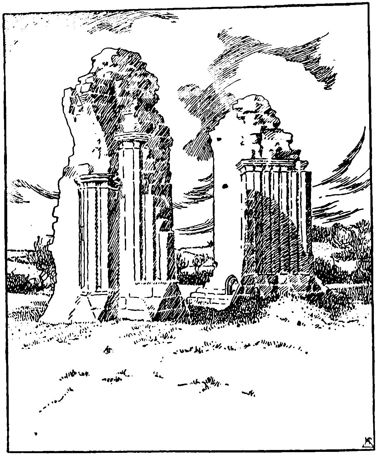
Immediately after the surrender it was ordered that the buildings of the priory should be demolished. The earl of Derby was very reluctant to destroy the church, his ancestors having been buried there, and offered to maintain a priest if permission were granted. (fn. 13) This must have been denied as the buildings have been demolished, the only conspicuous fragments now remaining being the northern piers of the central tower; portions of old walls remain just below the surface of the ground. In 1886 a systematic exploration of the ground on which the church stood was carried out, and many interesting details and remains of the building were found. (fn. 14)
The church was cruciform with a presbytery 42 ft. by 24 ft.; central tower 22 ft. 6 in. square; north transept 26 ft. 6 in. by 25 ft. 6 in.; south transept 24 ft. by 23 ft.; and nave 100 ft. by 24 ft. 9 in. with a north aisle 12 ft. wide. On the south side of the nave were the claustral buildings, the cloister being about 67 ft. square. The eastern and southern ranges were not cleared, but the approximate size of the frater, 54 ft. by 21 ft. was ascertained by sounding with a bar. About half the western range was uncovered, and the foundations of a building were cleared adjoining the north side of the north transept. The parts now above ground are the north-east and north-west piers of the central tower of the church, which stand to some height above the springing of the crossing arches, though the voussoirs of the arches themselves have been removed. The work is plain but good in design and workmanship, its date being c. 1280, and both transepts and the presbytery appear to have been of the same date.
Whether any part of the older church was discovered is not stated, but the gap between the east wall of the cloisters and the south transept suggests that the former is on the site of the twelfth-century cloister, and preserved the old arrangement after the eastward enlargement of the church c. 1280. The plan of the nave also may represent that of the twelfth-century church. A careful and complete excavation of the site is much to be desired.
Court rolls of the period during which the manor was held by the crown have been preserved. In 1536 the tenants claimed that they had by custom a bull, a boar, and a stallion, found by the priory, and they desired its continuance. They had 'followed scythe and sickle' with their cattle in the pastures until Candlemas, and in return they had given a hen for every cow, and calf calved. (fn. 15)
The lands of John Fletcher of Burscough were confiscated by the Parliament and sold in 1652; this seems to have been for recusancy only. (fn. 16) In 1717 estates in the township were registered by William Bradshaw, Richard Cropper, George Culcheth, and Edward Tristram of Ince Blundell, as 'Papists.' (fn. 17)

Burscough Priory Church: Northern Piers of the Crossing
John Houghton in 1733 left £10 for building a public school on the brow near the pinfold, and £100 as endowment. (fn. 18)
The reference in Domesday to MARTIN (fn. 19) shows that before 1066 one-half of it had been united to Harleton; (fn. 20) the other half is not mentioned, but it had probably been merged in Lathom. It is this latter portion which was bestowed by Robert de Lathom upon the newly-founded priory of Burscough in 1189, (fn. 21) and which apparently is the 'plough-land' referred to in the survey of 1212 as thus granted. (fn. 22) It appears, however, that the same Robert de Lathom had already granted land here to his nephew (nepos) Henry, from whom it descended to Henry de Radcliffe. The latter exchanged it for lands in Oswaldtwisle held by his brother Matthew, (fn. 23) whose son Richard about 1240 resigned Martin to the prior and canons of Burscough. (fn. 24) After its acquisition by the canons, this half of the original Martin became part of Burscough; yet as late as 1366 the whole is called Burscough-with-Martin. (fn. 25) Agreements were made in the latter part of the thirteenth century as to the boundaries between Burscough and Martin on the one side and Scarisbrick and Harleton on the other. These were supplemented by others a century later. (fn. 26) Martin Grange was retained by the canons among their demesne properties, and the earl of Derby had rented it of the king's commissioners in 1538. (fn. 27) Others of their lands there had been leased out just in the same way as those in Burscough described above. (fn. 28)

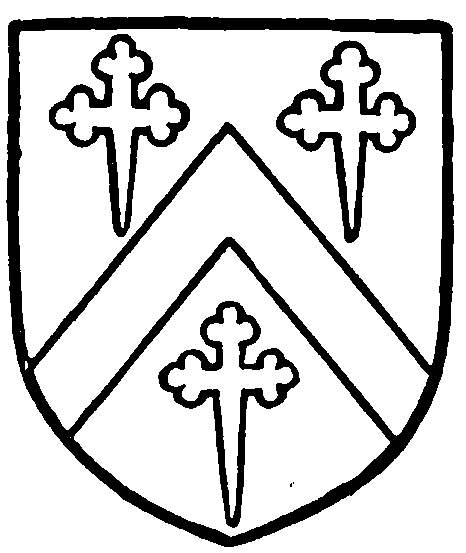
Wrightington of Wrightington. Sable, a chevron argent between three cross crosslets fitchée or.
In 1612 Martin Hall or Grange was granted to John Breres of Martin, who appears to have sold it to the Wrightingtons of Wrightington, under whom he became tenant. (fn. 29) It descended with the Wrightington estates until recently, when it was sold to the earl of Derby.
In 1694 an Act was passed for ratifying and confirming an indenture of lease of Martin Mere, made by the earl of Derby to Thomas Fleetwood. (fn. 30)
There is a Wesleyan chapel at Burscough.