A History of the County of Gloucester: Volume 12. Originally published by Boydell & Brewer for Victoria County History, Woodbridge, 2010.
This free content was digitised by double rekeying. All rights reserved.
'Newent - Introduction', in A History of the County of Gloucester: Volume 12, ed. A.R.J. Jurica (Woodbridge, 2010), British History Online https://prod.british-history.ac.uk/vch/glos/vol12/7-13 [accessed 19 April 2025].
'Newent - Introduction', in A History of the County of Gloucester: Volume 12. Edited by A.R.J. Jurica (Woodbridge, 2010), British History Online, accessed April 19, 2025, https://prod.british-history.ac.uk/vch/glos/vol12/7-13.
"Newent - Introduction". A History of the County of Gloucester: Volume 12. Ed. A.R.J. Jurica (Woodbridge, 2010), British History Online. Web. 19 April 2025. https://prod.british-history.ac.uk/vch/glos/vol12/7-13.
In this section
NEWENT
THE town of Newent stands 12 km (7½ miles) north-west of Gloucester close to the county boundary with Herefordshire in a large parish that extends to within 7.5 km (4¾ miles) of the city. The settlement, which was of evident importance in Anglo-Saxon times, was formed into a town by the Norman abbey of Cormeilles which in the 13th century maintained a priory and established a market there. It enjoyed modest success as a trading centre, particularly in the 17th century and the early 18th when tanneries, cloth making, and the nearby Ellbridge iron furnace all contributed to its livelihood. In the late 18th century hopes of greater prosperity were kindled by the building of the Hereford and Gloucester canal, the associated development of a coalfield, road improvements, and the promotion of a spa, but Newent remained small, providing marketing and local government services to surrounding villages. In the late 20th century it was much enlarged by new housing and became principally a dormitory town for Gloucester.
From the early Middle Ages Newent parish comprised several manors and numerous freehold and tenant farms. In later centuries the number of farmsteads was reduced as farms were enlarged, and cottages accumulated on commons and waste land. The largest of the new settlements were the dispersed hamlets of Gorsley and Kilcot, formed on part of Gorsley common adjoining the Herefordshire boundary, and Clifford's Mesne, on the northern slopes of May hill. Smaller hamlets were based on roadside greens at the parish boundaries. A later community, of a more planned nature, was established in the 1930s as a project of the Land Settlement Association.
BOUNDARIES AND DIVISIONS
Map 2. Newent parish 1882
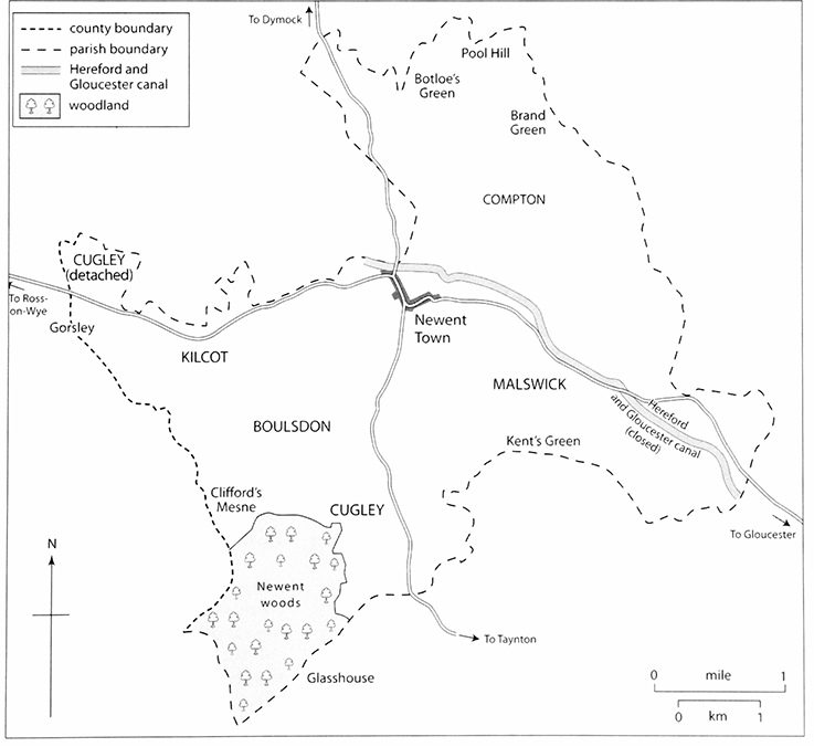
The ancient parish, one of the largest in the county, comprised 8,091 a. (3,276 ha) and bordered 11 other Gloucestershire and Herefordshire parishes (including both parts of Pauntley and a detached part of Much Marcle). (fn. 1) Its boundaries, which in many places crossed common land and woodland, were not in the main marked by distinctive features. In places they followed a lane or a water course, including on part of the east a small stream known by 1618 as Knowles's brook, (fn. 2) but frequently they respected those features for only a short distance, as in the north where the Ell brook and a tributary and roads from Newent to Ross-on-Wye (Herefs.) and to Dymock were all touched. Even the county boundary, where it crossed Gorsley common, had few defining features; in 1719 the lord of Kilcot manor planted a series of oak trees to mark off his part of the common from Aston Ingham (Herefs.) to the south-west, as well as from a part to the north belonging to Newent manor. (fn. 3) On Pool hill common in the north-east the parishioners of Pauntley marked out the boundary in 1616 but were accused in the Newent manor court of taking in 6 a. of Newent. (fn. 4) Most of the settlements that formed on commons and greens straddled parish boundaries. In 1820 Newent and Aston Ingham agreed a minute diversion of the boundary to make it follow the party wall in a pair of cottages, so avoiding potential disputes over poor-relief allocation. (fn. 5)
Within its boundaries the parish comprised six ancient tithings known in the early 16th century as 'aliwaters', (fn. 6) a term of obscure origin that later appears in the form 'holywater'. (fn. 7) Newent tithing, which was also termed the borough or liberty of Newent, (fn. 8) occupied the north central part of the parish and included the market town with a wide area of demesne land of Newent manor and a few small tenant farms. Its boundaries can be roughly identified to include Ell brook on the north-east and north, Boulsdon Lane on the south, and a small tributary stream (once known as Ploddy or Bloody brook) (fn. 9) on the south-east.
The tithings of Compton, Malswick, and Cugley adjoined Newent tithing on the north-east, the southeast, and the south respectively and contained early farmsteads, mostly owing allegiance to Newent manor, and later hamlets on the parish boundaries. Compton tithing included Carswalls, recorded as a separate manor from the time of Domesday Book, and on the tithing's boundary with Pauntley were the hamlets called Brand Green, Compton Green, Pool Hill, and Botloe's Green. (fn. 10) Malswick tithing, straddling Ell brook and the main Gloucester–Newent road, included a distinct area of ancient estates called Okle and part of the hamlet of Kent's Green on the boundary with Taynton. The main part of Cugley tithing, centred on the road from Newent town to Taynton, included a manor called Southorle, based on the house called the Moat and recorded as a separate vill of Newent in 1300, and, adjoining it, an ancient estate called Stalling (later Stallions), recorded from 1181. (fn. 11) At its south end Cugley included the large tract of woodland called Yartleton woods on May hill, and adjoining the woods, just within the boundary with Taynton, there was once a small hamlet called Glasshouse Green. A detached part of Cugley tithing in the north-western arm of the parish formed part of Gorsley common (fn. 12) and from the early modern period was settled by cottages.
Boulsdon tithing occupied the south-western part of the parish, bounded from Cugley tithing by the Boulsdon brook; it probably took the second element of its name from the low ridge rising west of that brook. Originating as a separate manor in the late 11th century, it comprised ancient farmsteads near and on the road from Newent to Clifford's Mesne, a hamlet formed in the early modern period on the lower slopes of May hill at the south end of the tithing. The sixth tithing of the parish, Kilcot, occupied most of the north-western arm of the parish. Apart from the Conigree, site of one of its ancient manors, and a few other farmsteads at its east end, it comprised scattered cottages built as encroachments on Gorsley common. The nomenclature of Kilcot is confusing. As a manorial name it included at least a substantial part of the detached portion of Pauntley manor on the tithing's north side, while later as a settlement name it tended to be limited to the houses within the east part of the tithing, particularly those on the Newent–Ross road. Gorsley was also sometimes used as a manorial name, applied to some small farmsteads in and adjoining the detached part of Pauntley, (fn. 13) while as a settlement name it was applied loosely to all the houses on the common, both within Newent and over the county boundary in Linton.
Major adjustments were made to Newent's boundaries in the late 20th century. In 1965 part of Aston Ingham, including the Oaks farmhouse and other houses adjoining Clifford's Mesne, was added to Newent. (fn. 14) In 1992 the parish was reduced in area by the transfer of houses near Glasshouse hamlet on May hill and at Kent's Green to Taynton, to the south, and by the redrawing of its boundary on the north-east and east to transfer land and houses at Pool Hill, Compton Green, and Brand Green to Pauntley, at Hook's Lane, Grinnell's hill, and Madam's wood to Upleadon, and at Layne's Farm, Red hill, and Leachford (formerly Lydenford) to Rudford and Highleadon. (fn. 15) In 2000 Kilcot and the part of Gorsley within Newent were formed into a separate civil parish called Gorsley and Kilcot. (fn. 16) The settlement of Gorsley thus remained for civil purposes divided between parishes and counties, though the parts within Newent and Linton, together with a wider area in the west of Newent including Kilcot and Clifford's Mesne, had formed a separate ecclesiastical district since 1872. (fn. 17)
LANDSCAPE
The land is formed mainly by the Triassic New Red sandstone in the north-east and the Old Red sandstone of the Devonian period in the south-west. On the slopes of May hill older, Silurian sandstones outcrop, forced to the surface by the fold known as the Malvern fault. (fn. 18) The New Red sandstone is revealed in some deep-sided lanes, including one south of the house called the Conigree (Conigree Court) where a cutting was made in 1807, (fn. 19) Hill Top Lane by the Ell brook north-east of Newent town, and others near Botloe's Green and Compton Green. At the break between the Devonian and Triassic rocks, running through Boulsdon and Kilcot tithings, coal strata occur near the surface (fn. 20) and were worked sporadically, the main period of activity being the late 18th century and early 19th. (fn. 21) On May hill, the dominant feature of the landscape, land within Newent climbs to above the 260-m contour. Most of the rest of the parish is gently rolling countryside at around 30–50 m but the hilly nature becomes more pronounced again at its north end, around Botloe's Green and Pool Hill, where the land rises to between 70 and 80 m.
Much of the land drains to the Ell brook, which in its long progress through the parish flows northwards through Kilcot tithing, turns eastwards along part of the north boundary, and then arcs south-eastwards through Malswick tithing to join the river Leadon on the boundary between Upleadon and Highleadon. The brook's main tributary is the Boulsdon brook, (fn. 22) which rises on May hill and flows northwards through Boulsdon tithing to Newent town. Near the town it was usually called in the Middle Ages Coleford brook, after the ford where it crossed Boulsdon Lane, (fn. 23) but within the town it has been called since at least 1329 Peacock's brook, (fn. 24) probably after a local family. (fn. 25) Among smaller tributaries are those mentioned above, the brook forming part of the parish's north boundary before joining Ell brook on the boundary between Oxenhall and the detached part of Pauntley, Ploddy brook rising in Cugley near the house called the Moat, and Knowles's brook forming part of the east boundary in Malswick. In the more low-lying parts of the parish several houses attached to manor estates were protected by moats. In the 17th century three large ponds were built on Gorsley common to store spring water for the Ellbridge iron furnace several miles away in Oxenhall parish. (fn. 26) The Great Pool and the Middle Pool, built before 1670, (fn. 27) straddled the boundary with Linton; covering together 25 a., they fed a watercourse which ran north-eastwards to join the tributary of Ell brook at the north boundary of the parish. (fn. 28) Smallbrook Pool was built in 1694 where a brook of that name crossed the boundary with Aston Ingham before continuing over the common to join Ell brook at Gorsley ford. (fn. 29) The ponds and associated watercourses were maintained until the ironworks went out of use in the mid 18th century. (fn. 30) The ponds were drained (fn. 31) and the sites became pasture closes, but the rubble and earth dams that had contained them survived largely intact but much overgrown in 2007.
The main tract of woodland in what was generally a well wooded parish clothed the northern slopes of May hill and was known in the Middle Ages as Yartledon woods (from the old name of the hill). The name later took the form Yartleton, and from the early 19th century the woods were usually known as Newent woods. Mentioned in 1181, (fn. 32) Yartleton woods remained one of the chief assets of Newent manor for many centuries. For a period up to the early 14th century, however, management of the woods, with others further north belonging to Boulsdon and Kilcot manors, was curtailed by the inclusion of part of Newent in the bounds of the Forest of Dean. Yartleton woods were long managed as oak coppice, but in the early 20th century after being acquired by the Huntley Manor estate much was replaced with conifers. (fn. 33) The woods were said to cover 595 a. in 1660 and were surveyed as 674 a. in 1775. The parts on the higher slopes, southwest of the lane leading from Clifford's Mesne to Glasshouse, were known in the 18th century as Cockeridge hill and College wood, the latter presumably in reference to Fotheringhay college, owner of Newent manor in the late Middle Ages. On the lower slopes the main part was known as Fair Oak wood, a part adjoining Clifford's Mesne as Mesne (Mine) wood, and a smaller part adjoining the farm called Black House as Jordan's grove. (fn. 34) That Jordan's grove was tithable, unlike the rest of Yartleton woods which as demesne of the former lords, Cormeilles abbey, were tithe-free, (fn. 35) indicates that it was included in the abbey's grant of land in that area to Robert Jordan in the early 13th century. (fn. 36) The grove belonged to the owners of the adjoining farmland in the mid 17th century (fn. 37) and was sold to Thomas Foley, the lord of the manor, in 1665. (fn. 38) Robert Jordan's grant included an assart, which, with other evidence of assarting in Cugley tithing in the 12th and 13th centuries, (fn. 39) suggests considerable early medieval clearance of woodlands on the slopes below Yartleton woods. About 1315 two tenants of Newent manor, who had houses at or near the sites of Little Cugley and Ploddy House Farms, held parts of an alder grove (alnetum) called Black moor (Blakemore), (fn. 40) which was probably absorbed later into their farmland.
Woods near the west boundary of the parish, north of May hill, originally belonged to Boulsdon manor. They included Acorn (or Hacking) wood, the north part of which was sometimes called Lady grove, (fn. 41) and Spring wood; in 1838 the former covered c.80 a. and the latter 23 a. Further north Kilcot wood, originally part of the Kilcot manor based on the house called the Conigree, covered 72 a. in 1838. On the east boundary of the parish, adjoining the larger Collin Park wood in Pauntley, Madam's wood (also sometimes called Collin's Hill wood) covered 41 a. in 1838. (fn. 42) In 1516 the manor of Okle Clifford, in Malswick, included three small groves and a wood called Gravenhill; (fn. 43) the wood was in the area of Grinnell's hill on the Upleadon boundary and was partly converted to farmland before 1819. (fn. 44) Small groves and coppices remained on many other farms in the early modern period. (fn. 45)
The main tract of common land, Gorsley common, occupied much of the north-western arm of the parish and extended into the adjoining Herefordshire parishes. Within Newent the northern part of the common, bounded by the Oxenhall woodlands on the north, the boundary with Linton on the west, and ancient inclosures forming Gorsley Court and Brassfields farms on the east, belonged to Newent manor as a detached part of Cugley tithing, (fn. 46) while the southern part, between Aston Ingham on the south-west and Kilcot wood on the east, belonged to Kilcot manor. The northern part may represent the wood on Newent manor that was mentioned as Tedeswode in 1181 and 1286, (fn. 47) for that name, which survives at Tedgewood Farm in Upton Bishop (Herefs.), appears to have been used in the early Middle Ages for the whole of the large tract of woodland that straddles the county boundary. (fn. 48) Possibly all of Gorsley common was part of that woodland in the early Middle Ages, being cleared later by uncontrolled commoning of animals and taking of timber. In 1624 the part belonging to Newent manor was estimated at c.240 a. and described as covered with gorse and heath. It had already been subjected to some encroachment by cottagers, (fn. 49) and by 1775, when an accurate survey extended it at 246 a., 91 a. had been encroached. (fn. 50) The part belonging to Kilcot manor probably covered 200 a. or more. It was subject to similar encroachment in the late 18th century, and in 1806 over 40 a. was said to have been inclosed and many cottages built within the previous 20 years. (fn. 51) By 1838, except for a patch of land known as Kilcot green on the Newent–Ross road and a few strips of roadside waste, that process had engulfed all of Gorsley common within Newent parish. (fn. 52)
On the lower slopes of May hill the common called Clifford's Mesne by 1677 belonged to Boulsdon manor. (fn. 53) Encroachment there had begun by the late 18th century (fn. 54) and what remained of the common was mostly inclosed by the owner of the manorial rights in the late 19th century. (fn. 55) The smaller commons in the parish were also subject to gradual encroachment by cottage building. In 1775, of those belonging to Newent manor in Compton tithing, 5 a. at Botloe's green, 10 a. on the part of Pool hill common within Newent, and 8 a. at Brand green remained uninclosed; (fn. 56) all of Picklenash green on the Ross road north of the town had been encroached by then. (fn. 57) By the time of the Commons Registration Act of 1965 the former commons of the parish, which included also Okle green in Malswick tithing and part of Highleadon common at Red hill on the east boundary, (fn. 58) were represented only by small patches of roadside waste. (fn. 59)
COMMUNICATIONS
Roads
The principal route through the parish came from Gloucester through Malswick to Newent town, from where it branched westwards to Ross and northwards to Dymock. It gave Newent a modest importance in the pattern of travel in the Middle Ages. Henry III passed through the town on his way from Gloucester to Hereford in 1226, (fn. 60) and cattle drovers from Wales came regularly through towards Gloucester in the 13th century. (fn. 61)
The road through Malswick, entering the town at its eastern end, was described as the 'great street' in 1228. (fn. 62) It appears to have been always the preferred route from Gloucester to Newent, (fn. 63) but there may have been an alternative in a road branching from it in Rudford parish, passing through Tibberton and Kent's Green, and entering Newent by Bury Bar Lane, which leads into the town's central market area. (fn. 64) The course of the latter route from near Caerwents Farm, west of Kent's Green, survives only as an ill-defined footpath but near the town, where it climbs a low ridge to the place called Bury Bar, it forms a deep hollow way. At Bury Bar it was referred to in 1657 as the lane leading from the town to Nelfields (fn. 65) (a farmhouse reached by a footpath from the lower end of the hollow way), suggesting that it was not then a recognized route to Gloucester. It may, however, have been one of two routes to Newent referred to by the Gloucester and Hereford turnpike trustees in 1727 when they decided to concentrate their efforts on only one. (fn. 66)
The Ross-on-Wye road, running westwards from the town through Kilcot tithing, formerly traversed Gorsley common by a winding lane that crosses the Ell brook at Gorsley ford. The Dymock road crosses the Ell brook north of the town at Ell bridge, for the repair of which the prior of Newent had a grant of oak timber in 1266. (fn. 67) Newent and Oxenhall parishes later took joint responsibility for repairing the bridge (fn. 68) and co-operated in rebuilding it in 1710. (fn. 69) North of the bridge, where within Oxenhall it climbs a hill known as Lambsbarn pitch, the road was recorded in 1693 as the highway to Dymock. (fn. 70) It seems likely, however, that in ancient times the route to Dymock ran along the Newent–Oxenhall parish boundary further east, following part of a lane called by 1344 Sandy way (fn. 71) before branching northwestwards to join the present route near a place called Three Ashes. A croft in Newent parish described in 1363 as adjoining highways from Newent to Dymock and to Botloe's green, (fn. 72) probably lay within the angle made by the lane to Three Ashes and the northern continuation of Sandy way. The lane linking Sandy way and Three Ashes was among a number of roads in Newent that were declared redundant and closed as highways in 1819. (fn. 73) The continuation of Sandy way, running by way of Botloe's green and Pool hill to cross the Leadon at Ketford, was described as the road from Newent to Ledbury (Herefs.) in 1776, (fn. 74) but possibly the road through Dymock was the more usual route between the two towns even before it was turnpiked in 1768.
The network of minor roads and narrow lanes in the parish was particularly complex south and south-west of Newent town. The principal road in that area left the town by Culver (formerly Coleford) Street and ran southwards through Cugley tithing to Taynton and Huntley. It was crossed by various routes giving access to the main Newent–Gloucester road in the east. One route, presumably used as a way to Gloucester by inhabitants of Gorsley and Kilcot and by travellers on the Ross road not needing to go through the town, followed Conigree Lane, running south-west of the house of that name, and Boulsdon Lane and crossed the Taynton road at the south end of Culver Street. East of Culver Street, where it was described in 1333 as the road from Boulsdon to Gloucester, (fn. 75) it continued south of Southend Farm to join the road mentioned above, running from Newent town by way of Caerwents Farm, Kent's Green, and Tibberton; most of its course east of the crossroads on Culver Street was discontinued as a highway in 1819. (fn. 76)
Further south on the Taynton road another junction was marked by a small green called by the 1520s Bromwich (or Bromage) green (fn. 77) and in 1624 Bromwich Oak green. The Taynton road was once joined there by a lane running from Great Boulsdon Farm and crossing the Boulsdon brook to the north-west (fn. 78) and by another climbing over Stallions hill to the south-west; the latter was used by Newent priory as a route to its Yartleton woods in 1285 when the owner of the Stallions estate attempted to stop its wagons passing through his court. (fn. 79) South of the green a lane from Clifford's Mesne to Kent's Green forms a crossroads that was called Anthony's Cross by the 1520s. (fn. 80) Near the parish boundary Judge's Lane, leading down from Glasshouse hamlet, joins the Taynton road, which crosses the brook on the boundary by a bridge built at the joint expense of Newent and Taynton in 1813. (fn. 81)
A lesser route leaves Newent town on the south-west by Watery Lane and traverses Boulsdon tithing to Clifford's Mesne. It was crossed in Watery Lane (by the site of the 19th-century cemetery) by a route from Oxenhall, which in turn crossed the Ross road at Stoney bridge on the parish boundary and beyond Watery Lane continued to join Boulsdon Lane at the ford by Lower Boulsdon Farm; parts of that route were closed in 1819 and survive only as footpaths, but the section north-west of Watery Lane remained open and with a branch running north-eastwards to Picklenash green is called Bradford's Lane. (fn. 82)
Compton tithing in the north-east part of the parish was criss-crossed by a similar network of lanes with crossroads and greens forming minor focuses, as at Compton green, Botloe's green, Limetree on Sandy way, and the place called by 1768 Three Cocks (fn. 83) on the road from Newent to Upleadon and Tewkesbury. The last road leaves the Dymock road north of Ell bridge to reach the parish boundary at Eden's Hill. In Malswick tithing a road from Gloucester to Upleadon by way of Highleadon green crosses Ell brook at the parish boundary by Lydenford bridge, for which the lords of Newent and Upleadon shared responsibility in 1387. (fn. 84)
The Gloucester-Newent road was made a turnpike in 1726 under an Act which covered routes leading from Gloucester towards Hereford and South Wales. (fn. 85) In 1768 the road running northwards from Newent to Dymock and thence to Ledbury was included in the same trust. (fn. 86) In the late 18th century, however, the roads around Newent remained in a very poor state of repair, their condition among the worst encountered by Samuel Rudder, the Gloucestershire historian, in his travels in the county in the 1770s. (fn. 87) Under an Act of 1802 powers were given to build a new line for the Newent–Ross road to join an existing turnpike from Mitcheldean to Hereford at Crow Hill, in Upton Bishop. (fn. 88) It was completed in 1810 (fn. 89) and included a new straight course across Gorsley common, branching from the existing road at a place in Kilcot that became known as Cross Hands. (fn. 90) Also turnpiked under the same Act was a road leading south from the Ross road at Kilcot to join the main Gloucester–Ross road at Lea Line. At the same period there were also improvements to the Gloucester turnpike to Newent, (fn. 91) enabling the route through Newent town to be promoted as an alternative coaching route between Gloucester and Hereford; (fn. 92) by 1822 a coach service ran through the town on six days a week. (fn. 93) In 1812 a separate district of the Gloucester and Hereford trust was created to cover the Gloucester road from the south boundary of the parish and its continuation from the town through Dymock towards Ledbury, (fn. 94) and an Act of 1824 consolidated that district with the Ross road trust to create a new Newent trust. (fn. 95) In the early 1830s tolls were collected at gates near Layne's Farm, where the Gloucester road entered the parish, at the junction with Cleeve Lane at the entrance to the town, on the Dymock road at Ell bridge, and on the Ross road just west of the junction with Conigree Lane. (fn. 96) The Newent trust's roads ceased to be turnpikes in 1874. (fn. 97) During the 20th century the network of roads in the parish remained little changed, but the Gloucester and Ross roads became increasingly busy as a result of new building around the town and the opening in 1960 of the M50 motorway with a junction on the Ross road 5 km west of the town, in Linton parish. The increase of traffic led to the opening in 1968 of a short bypass, skirting the town from the Gloucester road on the east to the junction of the Ross and Dymock roads on the north. (fn. 98)
Canal and Railway
The Hereford and Gloucester canal traversed the east side of Newent parish running close to the Ell brook for several miles. The first Act for the project, passed in 1791, envisaged a route along the valley of the river Leadon with a branch to Newent, but the plan was revised to take the main line through Newent, where the development of the coalfield was the chief incentive. Under powers granted by a new Act of 1793 work began from the Gloucester end, and by 1795 the canal had progressed to Newent and by 1798 as far as Ledbury. (fn. 99) Although new pits were opened, the results of the coalfield development were disappointing (fn. 100) and the completion of the canal, to Hereford, was not achieved until 1845. (fn. 101) A wharf to serve Newent town was established on the canal near Ell bridge. (fn. 102)
In 1870 the Great Western Railway took over full management of the canal with the option to convert it to a railway. Work on the railway began in 1881 and was completed in 1885. For much of its course through Newent it made use of the canal bed. A station for Newent was built near Ell bridge and in 1938 a halt was opened in Malswick. The railway was closed for passenger traffic in 1959 and for freight in 1964. (fn. 103) Later in the 1960s part of its course north-east of Newent town was used as the route of the new bypass road.
POPULATION
The 34 tenants mentioned at Newent in 1086 are probably not a good indication of the number of households at that time as most of their holdings were large. (fn. 104) By the early 14th century, when 137 houses were recorded in the town and there were probably another 150–200 in the outlying areas, (fn. 105) the population is likely to have been well over 1,000; 105 wealthier inhabitants were assessed for the subsidy in 1327. (fn. 106) Loss of some smaller farms in the late Middle Ages presumably led to a decline in population. In 1551 there were said to be c.712 communicants, (fn. 107) and in 1563 190 households. (fn. 108) During the early modern period, with the general prosperity of agriculture, a diversity of occupations in Newent town, and the building of new cottages on the parish's commons, there was a gradual growth in population. In 1650 the parish was said to contain 300 families, (fn. 109) about 1710 c.1,100 inhabitants in 270 houses, (fn. 110) and about 1775 c.1,560 inhabitants. (fn. 111) In 1801 2,354 people in 459 houses were enumerated, and a steady rise continued in the early 19th century, reaching 2,859 by 1831 (1,346 in the town and adjoining parts of Newent tithing and 1,513 in the five other tithings) and 3,306 by 1851. There was then a gradual fall to 2,485 by 1901 and to 2,299 by 1931. By 1951 the addition of housing estates to the town and the influx of over 50 families as part of the Land Settlement Association scheme had caused a rise to 2,912. With further new building the population reached 3,807 by 1971 and 5,373 by 1991. In 2001 the population of Newent civil parish was 5,073 and that of the new civil parish of Gorsley and Kilcot 277. (fn. 112)