Survey of London: Volumes 43 and 44, Poplar, Blackwall and Isle of Dogs. Originally published by London County Council, London, 1994.
This free content was digitised by double rekeying. All rights reserved.
'East India Dock Road, South side: Nos 2-238', in Survey of London: Volumes 43 and 44, Poplar, Blackwall and Isle of Dogs, ed. Hermione Hobhouse (London, 1994), British History Online https://prod.british-history.ac.uk/survey-london/vols43-4/pp153-170 [accessed 6 May 2025].
'East India Dock Road, South side: Nos 2-238', in Survey of London: Volumes 43 and 44, Poplar, Blackwall and Isle of Dogs. Edited by Hermione Hobhouse (London, 1994), British History Online, accessed May 6, 2025, https://prod.british-history.ac.uk/survey-london/vols43-4/pp153-170.
"East India Dock Road, South side: Nos 2-238". Survey of London: Volumes 43 and 44, Poplar, Blackwall and Isle of Dogs. Ed. Hermione Hobhouse (London, 1994), British History Online. Web. 6 May 2025. https://prod.british-history.ac.uk/survey-london/vols43-4/pp153-170.
In this section
- South Side
- No. 52, National Westminster Bank
- Nos 54–84 (Nos 56–84 demolished)
- Nos 86–102 (demolished)
- Nos 104–126 (Nos 106–126 demolished)
- Nos 128–150 (demolished)
- No. 152 East India Dock Road and Poplar Manor House (demolished)
- Malam Gardens
- Pope John House, No. 154
- Recreation Ground
- Wesleyan Chapel (later Poplar Methodist Mission), East India Dock Road and Woodstock Terrace (demolished)
- Nos 158–170 (demolished)
- United Methodist Free Church (demolished)
- Poplar Fire Station
- Poplar Baths
- Statue of Richard Green
- Poplar Railway Station (demolished)
- All Saints' Church and Rectory, see page 176
- Nos 174–238 (demolished)
South Side
Nos 2–50, see page 127.
No. 52, National Westminster Bank
This is unusual among East India Dock Road's Victorian buildings in being the third structure on the site. It was built in 1885 by Holloway Brothers as a branch of the London and County Bank, to designs by Zephaniah King, an architect who had been office manager to the bank's former architect C. O. Parnell. (fn. 2) Holloways had tendered for the work at £5,960. (fn. 3)
The staid exterior could stylistically be a generation earlier than its actual date (and is correspondingly more old-fashioned than a bank would have been then). The plan accommodated the manager's family on the upper floors, the only notable feature of the domestic arrangements being the unusually large dining-room that occupied half of the first-floor front — presumably to seat, and perhaps also to impress, the bank's clients (Plate 25b; fig. 47).
This building replaced a detached, double-fronted house called Canton Cottage, (fn. 4) built in 1856 by a local builder, John Jeffrey, for occupation by J. H. K. Bond, who had a mast- and block-maker's business in Fore Street, Limehouse. (fn. 5) This in turn had replaced a house of the same name, shown by Horwood in 1819 and built on the same Smith property as Nos 51–67 opposite.
Nos 54–84 (Nos 56–84 demolished)
This is an area mostly built up in the 1840s–1860s with substantial houses having deep gardens behind. Virtually nothing of interest remains, except at No. 54. The area was developed under the copyhold tenure (from the manor of Stepney) of Joel Langley, shipowner, of Salmon Lane, Limehouse, (fn. 6) being part of the land (of which a small portion lay north of the road) which the Langleys acquired from Mary Burch, who had been the owner when the road was made. (fn. 7) The Langleys gave the name 'Langley Place' to the whole frontage, 'Langley Villas' to Nos 60–66, and 'Langley House' to No. 54, where a brick pier bears that name and also a tablet incised LANGLEY PLACE.
The earliest houses were Nos 52, 54 (about 1829, for one of the Garford family of Limehouse oil merchants, later much altered and extended) and 84 (1831–3), which was first occupied by the Langleys. These were detached houses, as was 'Devonshire House' at No. 68, built about 1843–4. (fn. 8) Moderate-sized semi-detached pairs followed at Nos 70–72 (built in 1848 by a bricklayer, Thomas Clayden of Limehouse) and 74–76 (c1842), (fn. 9) probably as an enterprise of Thomas Carter, shipbuilder at Millwall, who had a lien on all four and lived at No. 74. (fn. 10) This house and No. 76, and probably the other pair, had the stair-well laterally placed between the front and back rooms, and the entrance at the side. (fn. 11) By 1853 William Black, the occupant of the big house at No. 54, had acquired the sites eastward of it, and had a terrace of four modest-sized houses built in that year at Nos 60– 66. (fn. 12) They had areas back and front and no closet wings at the rear. (fn. 13) In 1856–7 Joel Langley evidently thought a little more ambition justified and had a terrace of three bigger houses, with closet wings, built to designs by the local architect E. L. Bracebridge, at Nos 78–82: (fn. 14) this was part of a larger development including Oriental Street between Nos 82 and 84, and Morant Street at the back (see page 171). (fn. 15) Nos 78 and 80 were very soon rebuilt, in 1864: whatever the reason for this, a hundred years later the local authority found Nos 78–82 and 84 to be, like the houses in Oriental and Morant Streets, quite soundly built and in decent condition. (fn. 16) Finally, William Black had Nos 56 and 58 erected as a large and rather gaunt semi-detached pair east of his own house about 1862–3: probably Joseph Harris, living at No. 34, was the architect. (fn. 17) A hall was built at the back of No. 56 in 1939 for the Presbyterian Settlement to designs by the architect J. E. M. Macgregor. (fn. 18)
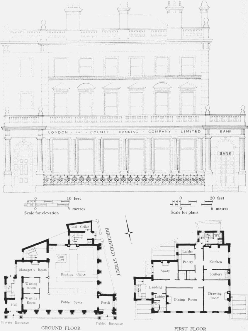
London and County Bank (now National Westminster Bank), No. 52 East India Dock Road, front (north) elevation andplans as built. Zephaniah King, architect, 1885
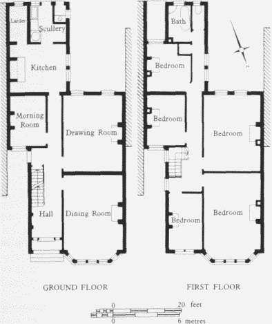
No. 68A East India Dock Road, ground- and first-floorplans. William Clarkson, architect, 1910. Demolished
Some of the first inhabitants, or their widows, were still in the houses in 1882, and John Lenanton at No. 56 presumably represents the higher ranks of local business. A lodging-house, however, was noted in the directories at No. 76 in that year and by 1892 this house was in the hands of a 'cemetery company'. (fn. 19) But as late as 1910 a fair-sized house was built for occupation by the Poplar contractor, G. J. Anderson, to designs by the local architect William Clarkson, on an unbuilt site about 30ft wide between Nos 68 and 70 and numbered 68A. It had wholly subterranean cellars, a dining-room, drawingroom, morning-room, kitchen, scullery, larder and outside water closet on the ground floor, and five bedrooms, a bathroom and a water closet on the first floor (fig. 48). The graceless external appearance showed the influence of suburban aspirations even in this not very promising location, with pitched, tiled roofs, and elevations realized, it seems, in brick, pebbledash and sections of timberwork. (fn. 20)
The estate agent William Warren lived at No. 54 by 1887 and he or his successors subsequently had liens on Nos 56, 60, 74 and 76, and possibly others: some renovations and up-datings in the 1930s were of their sponsorship. (fn. 21)
Nos 86–102 (demolished)
The site of these houses was part of the land lying west of North (now Saltwell) and Upper North Streets bought in 1803 by John Perry, and at that time was occupied only by two houses standing back from the road frontage, one of them a 'roomy brick dwelling house, with a spacious walled garden' occupied by Ralph Walker, engineer to the West India Dock Company. (fn. 22) They were taken on lease from Perry's son John in 1812 at £70 per annum and one of them was occupied until about 1850 by John Garford, oil merchant. (fn. 23) No attempt seems to have been made to develop the frontage on this side of the road until 1858–62, when houses were built for John Perry's nephew J. W. Perry Watlington, evidently to designs by the architects John Morris & Son, (fn. 24) who had just designed houses for the same owner on the other side of the road. Perhaps John Warrington Morris, the 'son' of the firm, was especially involved as he was the first occupant of No. 90 in 1860–2. (fn. 25) The development comprised a cul-de-sac called Perry's Close, with four small bay-windowed houses with gardens on each side of it, and nine larger houses, three-storeyed, with dressed and pedimented window-openings, under the eaves of a hipped roof, in East India Dock Road at Nos 86–102. The builder, at least of Nos 86–100, was Adin Sheffield, who was the first occupant of No. 98 (and was still there in the 1890s with J. R. Adin Sheffield, architect). (fn. 26)
Nos 104–126 (Nos 106–126 demolished)
Like Nos 93–103, these houses were built on land sold off in lots in 1827 by William Wilkes, esquire, of Pimlico and Henry William Masterson, a merchant of Rotterdam. Here, the lots were sold to the schoolmaster-cum-property speculator. John Stock (Nos 104–110), the builders William Horne and James Gates (Nos 112–118) and the carpenter John Macord (Nos 122–126). (fn. 27) Building was delayed until 1831–7. (fn. 28) (fn. 1) On Stock's lot three-storeyed houses were built: the rest, like most of the houses at Nos 93–103, were humbly two-storeyed. (fn. 30) In 1841 the 12 houses, called India Row (Nos 104–114) and Prospect Terrace or Place (Nos 116–126), were occupied by a shipwright, an anchor-smith, a waterman, a landing waiter, two carpenters, a bricklayer, a builder, a clerk, a tailor, a surgeon (later employed at Poplar Hospital), and one occupant called 'Independent'. (fn. 31)
At No. 108 the builder, and lessee from John Stock, was the Poplar bricklayer, Joseph Blackburn. (fn. 32) At No. 110 the lessee of the 'lately erected' house was a James Lagden, who lived there until 1860. In the lease and in his will, which he signed with his mark, he described himself as cordwainer, (fn. 33) but in the 1841 census he is called a builder, (fn. 34) and he had been a 'developer' in the Wells Street area. At his death he left an estate — a mixture of leasehold, copyhold and freehold — consisting of 41 houses in Poplar (including No. 110) and four in Canning Town. It included 25 small houses around a court called James Place behind his house in East India Dock Road. The others were scattered in six other streets, north and south of the road. This domain of tenants he divided by his will among his widow and 12 brothers, sisters, nephews and nieces, some of them living at Saffron Walden. (fn. 35) Owner-occupancy was a rarity in the hinterland of Poplar's two chief thoroughfares.
The Phoenix at No. 104, with its recessed and rounded corner, may in carcase be of the 1830s, with a groundfloor front perhaps mainly of 1914. (fn. 36) A beerhouse in the 1850s, it was transformed by its licensee in 1975 from a 'dreary refuge for the human flotsam and jetsam from the docks' to 'the drinking place of his dreams — a true country inn'. (fn. 37)
Nos 128–150 (demolished)
This frontage represented that part of the Wade estate, south of the East India Dock Road, that extended from the old drainage sewer called the Black Ditch to the 'manor house' of Poplar. After Mary Wade's death about 1821 this part was, like the rest of the estate, partitioned among her daughters in 1823, and immediately put in train for development in the favourable speculative climate of the time. Three of the daughters divided this comparatively short frontage, and disposed of their plots to different developers, but conformed to an overall layout plan — possibly attributable to James Walker as the late Mrs Wade's surveyor.
The site of Nos 128–134 (and of Nos 22–26 Wade Street) was sold in August 1824 by one of the daughters, Sophia, and her husband James Duff to the builder Thomas Corpe of Limehouse. The price was £407, for about one-sixth of an acre. (fn. 38) A year later, with four of the houses built and four building, Corpe mortgaged them to the ubiquitous John Stock. (fn. 39) Greenwood's map of 1824–6 seems to show the East India Dock Road houses, but it was 1835 before they were occupied, under the name of Clarence Place. (fn. 40)
The site of Nos 136–142 was sold in April 1825 (together with the land that extended back to the line of Shirbutt Street) by Catherine Wade to Thomas Gray of Marylebone Street, Golden Square, bookseller, who later occupied Monastery House. (fn. 41) The houses, with Nos 144–150, were named Grove Terrace, which (at Nos 146– 148) bore that name-tablet dated 1827. (fn. 42) Nos 136–142 – houses of only two storeys — were first occupied in 1829 (No. 138) and 1835. (fn. 43) Gray's widow still owned them in 1880. (fn. 44)
In September 1824 the site of the rest of Grove Terrace at Nos 144–150 and of the land back to Shirbutt Street was sold by the Wade daughter Susannah and her husband James Grundy, himself a builder, to a trustee for a Shadwell pilot, George Smith. (fn. 45) These threestoreyed houses seem to have been the first houses to be occupied here, in 1828. (fn. 46) Smith's family, too, retained the ownership, in 1885. (fn. 47)
No. 150, the Manor Arms, became a beerhouse in 1868. (fn. 48) The present building probably dates from 1925 (Plate 40b). (fn. 49) The architect for Mann, Crossman & Paulin may have been William Stewart, who had extended the premises in 1911 and did so again in 1936–7. (fn. 50)
No. 152 East India Dock Road and Poplar Manor House (demolished)
Until the laying-out of Malam Gardens their site was occupied by a detached pair of conjoined houses of early nineteenth-century date, known collectively as the Manor House, and the comparatively extensive grounds in which they stood. This area, together with land westward to Wade Street, had at the time of the dissolution of the Abbey of Graces near Tower Hill been the site of the capital house of the manor of Poplar belonging to the abbot of Graces. The house, together with its fishponds, coneyboroughs and dovecotes, was not at that time let, but kept by the abbot in hand. (fn. 51) This house was not situated where the nineteenth-century Manor House stood, but a little westward, at the top of a lane or 'gate' from Poplar High Street (mentioned in a deed of c1536) on the later (and present) line of Wade's Place. It is shown in summary pictorial form on the manuscript map attributed to 1573 (Plate 145a) and in very small-scale plan on Horwood's maps of 1792–1819 and James Walker's of 1805. (fn. 52) Walker's and Horwood's maps agree in suggesting a building which was of half-H plan, the two wings coming forward in a direction south of east.
This house was the residence about 1553–7 of John Maynard, mercer and recently sheriff of London, 'the wyche kept a grett howse and in the time of Cryastymas . . . had a lord of mysrulle', and whose funeral pomps in 1557 were approvingly noted by Henry Machyn. Presumably Maynard rebuilt the house, as it was described by John Hart, Chester Herald, four years after Maynard's death as 'of new buylding, good substance, and well framed and conveyshed . . . which workemen say was never buylt for two thowsand pound'. (fn. 53) In November 1553 Maynard and his household were attacked here by 16 armed persons including 'Brigetta Carden, gentilwoman'. This lady was wife of a William Carden, to whom the house and grounds had been granted by John Dudley, Earl of Warwick (later Duke of Northumberland and proclaimant of Lady Jane Grey as Queen), who had died on Tower Hill three months before this armed affray. (fn. 54) Maynard's tenure was presumably from Mrs Carden. Whether the assault had any political aspect to it is not known. John Hart's comment of 1561 continues with a complaint that the house 'was of late sold by an evill heir for £356 or lesse . . . And now the byers have already spoyled all the entrayles, as tables Beddsteedes and wainscott wherewith every rometh was costly and comly garnisshed, with leade and paving stones, and so they plainly saye they will leave nor brik nor stone standing there. Yf buylders have gotten favour in beawtefyyng their Cuntry what reason ys yt such spoylers shuld be suffred.' (fn. 55) (Later, about 1590, documents relating to the leasehold tenure, which by then had passed into the hands successively of Sir Gilbert and Sir William Dethick, Garter Kings of Arms, were still in the hands of someone called Maynard.) (fn. 56)
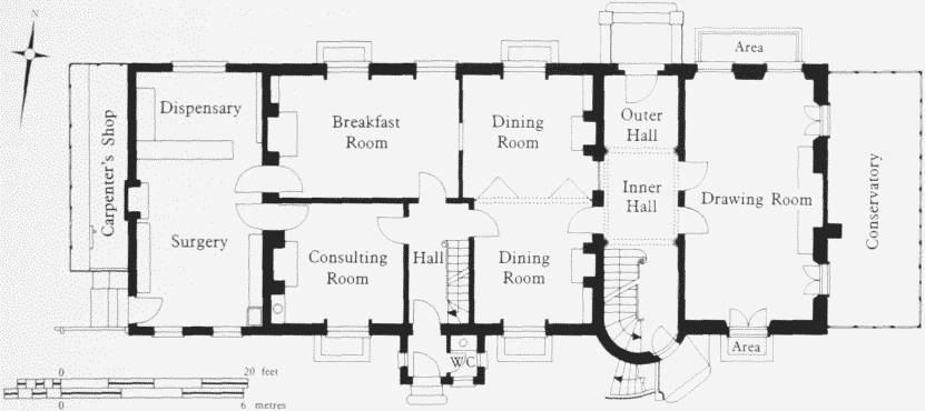
152 East India Dock Road (The Manor House), ground-floor plan in 1899. Demolished
Nothing is known of the history of the fabric of this house. Its ownership had become detached from that of the lordship of the manor by the time it was acquired in 1717 by Jeremiah Sherbut or Shirbutt, of Whitechapel, butcher, and founder of the family estate in Poplar possessed by the descendants of his son-in-law, Jeremiah Shirbutt Wade. (fn. 57) From about 1776 the house was occupied by members of the family. (fn. 58) It was probably in about 1812 that this house, then occupied by the widowed Mary Wade, was replaced by a new one a little eastward and standing well back from East India Dock Road. The old house had been demolished by 1823. (fn. 59) About 1821 Mary Wade died, leaving five daughters, and it was probably in some way in consequence of this that by 1824 a second house had been built immediately adjacent, the two being inhabited by a widowed daughter, Elizabeth Chrisp Willis, and another daughter, Sophia, with her husband James Duff. (fn. 60) The north fronts of the two markedly disparate houses in the 1890s can be seen in Plate 27a. Probably the plainer western (or right-hand) house was the earlier to be built, for Mrs Wade. Plans of 1899 seem to confirm indications in the photograph that originally it had its entrance on the north side, in the centre bay (fig. 49). The plans also show that the eastern house, effectively designed, despite its setting, very much like a street house, was built with a higher first-floor level than its neighbour. (fn. 61)
From about 1866 until 1916 the houses were occupied as one, successively by surgeons or physicians, Dr Francis Mead Corner, Poplar's active Medical Officer of Health, who died in 1908, and his son Doctor Frank Corner, an important benefactor of the London Museum in its early days. (fn. 62) In 1895 the house was viewed on behalf of the London Survey Committee, in the belief that it was on the actual site and might retain some fabric of the old 'manor house'. The notes then made and later photographs suggest that fluted wooden Ionic columns of eighteenth-century character probably came from the old house (Plate 27b). (fn. 63)
The property was bought by the Commercial Gas Company in 1932 for demolition (see below).
Malam Gardens
Malam Gardens was built by the Commercial Gas Company to house some of its employees. (fn. 64) It was adjacent to the company's Copartnership Institute (now Pope John House) in East India Dock Road and stands on the site of the Manor House Estate, which was bought by the company in 1932 for development, at a cost of £14,100. The estate covered about 1.25 acres and included the so-called Manor House, as well as several cottages. During 1933 No. 15 Shirbutt Street was also acquired and the unexpired lease on Nos 19–29 Shirbutt Street was purchased.
Plans for the new cottages were drawn up in 1934 by a private architect, Victor Wilkins, acting for the Company, and in November 1934 the lowest tender, from Messrs William Lawrence & Sons for £16,531, was accepted for the erection of the first 19 cottages (including also the construction of roads and footpaths, drains, water services, and boundary walls). The Manor House was demolished and by April 1935 all the old cottages on the estate had been vacated, so that it was possible to proceed with the building of the final ten cottages. Lawrence's were prepared to carry out the work on the same terms as the initial contract, at an estimated additional cost of £8,925
The company had hoped to call the new development Manor Cottages, but this was not acceptable to the LCC. Instead, the Council's Architect suggested Malam Gardens, after John Malam, patentee in 1820 of the first gas meter, and this the Company readily agreed to. The scheme was completed by the spring of 1936.
The 29 two-storey houses are arranged in three terraced rows, with Malam Gardens looping round the middle row and running off Wade's Place, while the northernmost row fronts East India Dock Road (Plate 127b). The density is about 19 dwellings to the acre. The houses are all to the same design. They are built of a mottled brown, red, and black brick, while the pitched roofs are covered in dark red tiles. One house in the northernmost row has had the elevation to East India Dock Road rendered in pebbledash. Each house had a living-room, kitchen, three bedrooms, bathroom and w.c. (fig. 50). The avowed object of building these houses was to demonstrate the efficiency and suitability of gas for lighting and heating. Each house was originally fitted with a gas cooker, gas water-heater, a coke fire in the living-room, and a gas fire in the first bedroom. Not only were the houses also lit by gas but so was the new street, and the gas streetlamps still survive in working order. However, the metal gates and gateposts which once guarded the entrances to Malam Gardens have now gone.
It was agreed that these houses would be let initially on three-year tenancies and would be offered to employees with not less than seven years service with the company. Nevertheless the rents were high for the area, the company charging 12s 6d exclusive of rates, which had to be paid by the tenants, who thus had to pay an inclusive rent of £1 a week.
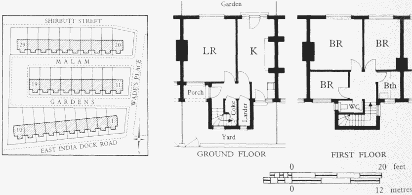
Malam Gardens, site plan and typical floor plans. Victor Wilkins, architect (for the Commercial Gas Company), 1934–6
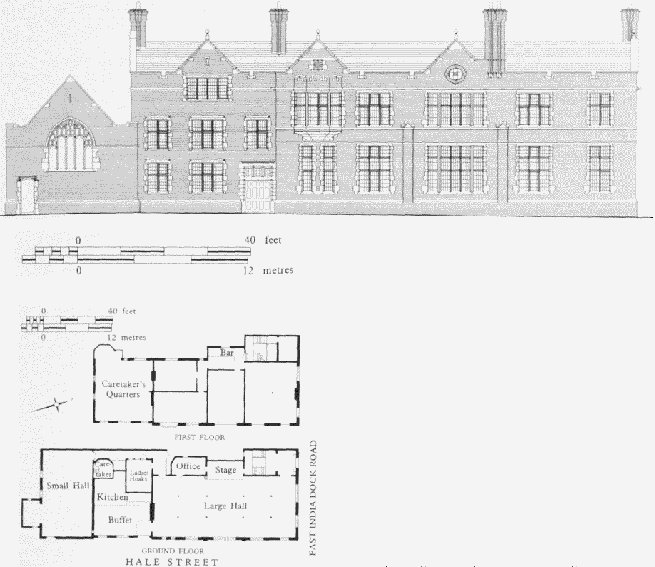
Pope John House (former Seamen's Institute), No. 154East India Dock Road, elevation to Hale Street, and plans. SirArthur Blomfield & Son, architects, 1893–4
Pope John House, No. 154
This site was first occupied in 1841 by the parsonage of Trinity Congregational Chapel on the opposite side of the road. In 1885 the church intended to build a school and new parsonage here, to be designed by the architects Spalding & Auld at a cost of £5,500. (fn. 65) Evidently nothing was done and in 1891 the Poplar library commissioners negotiated unsuccessfully to buy the site for £2,500 to accommodate Poplar's first public library. (fn. 66)
Instead the site was acquired for £3,500 or £4,000 in 1893 by the trustees for the Anglican Missions to Seamen, to provide 'a Seamen's Church, with Institute, Gymnasium, Coffee Bar, Class Rooms etc.', the Port of London being one of the worst equipped of the Missions' many British stations. The site was conveniently close to the Board of Trade building at No. 133, where seamen were paid off. (fn. 67)
The architects were Sir Arthur Blomfield & Son, who prepared designs in 1892, incorporating a range of buildings much as they were to be executed except that the church at the southern end was larger than was ultimately built and oriented north-south. (fn. 68)
The foundation stone of the Missions to Seamen's Institute was laid by the Duke of York in October 1893 and the building was opened by the Prince of Wales in June 1894. (fn. 69) The builders were Woodward & Company of Finsbury. (fn. 70) The cost, including the site, was about £13,500. (It is not clear whether this included the £5,369 donated by Lord Brassey to erect part of the building.) (fn. 71) In 1893 it had been reported that the building would be faced with Bath stone prepared on the site, (fn. 72) but it is brick-faced, in English bond, with stone dressings. The style is Jacobean, particularly effective on the long return front to Hale Street (Plate 25c; fig. 51). Inside, the main compartment on the ground floor was a large room divided longitudinally by a double row of columns. (fn. 73) A separate room on the first floor was provided for ships' officers and apprentices.
In 1898 a simple brick church, paid for by two sisters, was added by Woodward & Company at the south end to Sir Arthur Blomfield & Son's design. (fn. 74) Much smaller than first intended, it is correctly oriented and presents to Hale Street a broad stone east window of cusped panel tracery. The chaplain's house southward was built by Woodwards at the same time in a simplified Arts-andCrafts style (Plate 25d). (fn. 75) Whether this, too, was designed by Sir Arthur Blomfield & Son is not known. Trinity Cottage, at the corner of Shirbutt Street, and occupied by 'lady-workers' at the Institute, was altered in 1894 in a similar style, and rebuilt or recast in 1934. (fn. 76)
In 1932 the Missions to Seamen ceased its operations here, to follow the changing focus of activity in the Port of London to Victoria Docks. (fn. 77) The building was taken over as the Copartnership Institute of the Commercial Gas Company's staff, the chapel becoming a gymnasium. (fn. 78) In 1962 it was acquired by the Archdiocese of Westminster and opened in 1967 as a community centre called Pope John House, served by nuns of the Order of the Faithful Companions of Jesus. (fn. 79)
Recreation Ground
The closure of the East India Company's almshouses enabled the Poplar Board of Works to acquire their site, both north and south of St Matthias's church and churchyard, from the Secretary of State for India (see page 109). The price was variously stated at £10,150 and £12,000, towards which the Metropolitan Board of Works contributed £6,000. (This site by then included land between the northernmost range of almshouses and East India Dock Road that the East India Company had bought from Mrs Wade in 1818.) (fn. 80) The south-eastern corner of the ground, abutting on Poplar High Street and Woodstock Terrace, was appropriated for the new offices of the Poplar Board of Works, but the remainder was made a recreation ground, opened in May 1867. (fn. 81) The decorous layout of lawns, flowerbeds, shrubberies and curving paths can be seen in Plate 20b, together with the surviving stone gate-piers in East India Dock Road — perhaps faintly suggestive of the sub-continent in their top-heavy profiles. In about 1894 tennis courts were made on the north-eastern corner, and an octagonal bandstand erected on an existing 'platform' by Messrs Macfarlane, no doubt the well-known Glasgow ironfounders who supplied many such structures. (fn. 82) The tendered price was £229, and this included supplying the design. (fn. 83)
The main approach from East India Dock Road now contains a memorial, signed by the local undertaker A. R. Adams, to the 18 children killed by a bomb dropped on the Upper North Street School in 1917. It has an angel on a pedestal of white Sicilian marble with columns of Labrador granite.
At the north-east corner the recreation ground was slightly extended eastward in about 1958 to take in the former site of No. 156 East India Dock Road (Belle Vue House), erected about 1854 by Thomas Lawrence, builder, its first occupant, under lease from Edward Wood Stock as part of the development of Woodstock Terrace. (fn. 84) The rest of the site of No. 156 was thrown into a widening of the footpath at the northern end of Woodstock Terrace. The southern portion of the ground, abutting on Poplar High Street, has been extended to Hale Street, and is now used as bowling greens.
Wesleyan Chapel (later Poplar Methodist Mission), East India Dock Road and Woodstock Terrace (demolished)
This chapel was built in 1847–8 to designs by James Wilson of Bath (1816–1900) for a Wesleyan congregation hitherto worshipping in Hale Street. It was the first of two prominent Methodist churches to be built in East India Dock Road and is of interest as exhibiting a design that was in some degree officially approved by the Methodists for wider use (Plate 21b). The foundation stone was laid by the shipowner and shipbuilder George Green, who a few years before had had the Congregational Trinity Church built on the other side of the road. Here he contributed 500 guineas towards the eventual total cost of £7,350. (fn. 85) The site was at the northern end of the land of Edward Stock in Poplar High Street, from whom it was bought for £940 (and with so little trouble that the congregation thought it 'altogether an astonishing affair'). It occupied partly Stock's garden and partly his 'lawn' situated on ground between the garden and East India Dock Road, which his schoolmaster father John had bought from the Wade family in 1822. (fn. 86)
The building was as unlike Trinity church as possible, being in a Decorated Gothic style. The congregation's building committee had gone to view 'various chapels' in November 1846 when it learned that the Methodist Conference, in Manchester, had decided to ask 'four first rate Architects' to supply it with designs 'for Chapels of various Dimensions and of different orders of Architecture for the guidance of those intending to build'. Wishing their new chapel to be 'erected as a Model Chapel' the committee paused, and in February 1847 chose as their architect James Wilson of Bath, 'he having obtained the two first Prizes for Plans etc.' from the Conference. In March he was asked to make designs 'of the Gothic order' and in May they were accepted. (fn. 87) Wilson was already an experienced architect of chapels, churches and schools in the west of England, his chief work being at Cheltenham College (1841–3). He went on to design buildings for the Methodists in Islington, Clerkenwell and Westminster in 1848–50. In East India Dock Road the builders were Robert & Edward Curtis of Stratford (who probably also obtained the Islington and Westminster commissions). (fn. 88) Here they had tendered at £4,394 in a rather thin field, the 'Metropolitan Builders' and those at Bath who had been approached not being eager to tender (possibly because they were required to estimate their own quantities). (fn. 89) The foundations were put in under a separate contract with another builder. (fn. 90) The architectural fittings were supplied by Messrs Curtis extra to contract — a Caen-stone screen for £148 10s, the pulpit for £52 10s and the font for £12. The windowglass was also an 'extra'. All these extras were financed by a fund-raising ladies' committee. (fn. 91)
Oriented north-south, the chapel measured externally 105ft by 62ft, and was about 60ft high. It accommodated 1,456 worshippers (Plate 21c; fig. 52). There were large windows filled with flowing tracery at the north and south ends, that at the north end, on East India Dock Road, being separated by pinnacle-topped buttresses from smaller windows set over the entrances from the road. The gable-ends and angle-buttresses were also topped by pinnacles. The side elevations contained tall windows separated by stepped buttresses. (fn. 92) As first built all the walls were finished with an 'open flowing tracery parapet' but this had gone by the 1920s. (fn. 93) The rather pretty, ornate style of the exterior would perhaps have been better set off by the smooth ashlar shown on an early view of the design than by the coursed Kentish ragstone, dressed with Caen stone, of which it was constructed a material decided on only some months after the design was accepted. (fn. 94) Inside were large galleries at the north end and at both sides, resting on pillars probably of iron. (fn. 95) The shallow-pitched ceiling, supported by moulded ribs with cusped perforations in the spandrels and rising from stone corbels, was of plaster, concealing the timber roof. (fn. 96) The organ, for the purchase of which £935 was allowed, was said to be 'very fine'. It was by Hill (probably William Hill of the Euston Road) (fn. 97) and stood at the south end, behind the graceful Decorated Caen-stone screen and pulpit. (fn. 98) At that end was a rose window, filled, as were all the others, with stained glass by W. Wailes of Newcastle upon Tyne. (fn. 99)
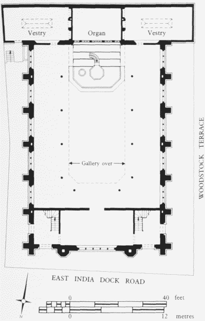
Wesleyan Chapel, East India Dock Road, plan. JamesWilson, architect, 1847–8. Demolished
Special attention seems to have been given to the construction of the timber roof. The iron bolts used to secure the trusses had been galvanized and the builders were fearful, when some broke on being driven in, that this process had weakened them. Because of this, the building committee, the builders, and the architect attended a test of one of the framed principals of 50ft span in February 1848, when, under hydraulic pressure, it sustained satisfactorily a weight of nearly 20 tons. (fn. 100) Two structural surveys by the Metropolitan Buildings Office followed before the church was opened, as 'the first Model Wesleyan Chapel', in June 1848. (fn. 101) It was commented that the church was 'faced by handsome villas' (of which one survives at No. 153). Only a third of the sittings were free. (fn. 102)
In 1886 the Limehouse builders Harris & Wardrop, tendering at £1,093, added two-storey classrooms and a lecture hall at the south end (architect J. F. Wesley). (fn. 103) In 1910 a restoration under an architect with a strong Methodist connection, Josiah Gunton, saw the addition of a rostrum, 'the front of which has been built out of the old pulpit', choir pews, and an 'orchestra platform'. (fn. 104) The pinnacles on the outside were trimmed off about 1925–7. (fn. 105) Then in 1933 the exterior underwent a marvellous (but not altogether unsuccessful) change to modernism, blown onto the pared-down structure through a 'cement-gun'. The contractors were George Parker & Son of Peckham, under the direction of Josiah Gunton's firm, Gunton & Gunton, architects. A floor was inserted, the church, now accommodating 900 worshippers, being confined to the upper storey. The new south end was fitted with a plain oak rostrum-and-pulpit. If all the intentions were carried out, the old roof was retained but the 'beautiful stained glass windows' were 'blocked up and replaced [sic] by ones of more modern design'. The rose window over the altar was, however, to be retained. A new stained-glass 'memorial window' (now placed in Trinity Methodist Mission church on the other side of the road) was designed by Frank Salisbury. The cost of it all was £11,500. (fn. 106)
The church was damaged during the war but reopened, and was closed in 1976, when its function as Poplar Methodist Mission was transferred to the former Trinity Congregational church (see page 225). (fn. 107) Its site is now occupied by Nos 156A-H East India Dock Road (William Lax House) and Nos 1 and 2 Woodstock Terrace, built to designs by Dex Harrison & Pollard, architects (plans dated 1976). (fn. 108)
Nos 158–170 (demolished)
Immediately east of the Wesleyan Church were the three plain three-storeyed houses of Wesleyan Terrace at Nos 158–162, built in 1855 by Thomas Lawrence, the builder who occupied No.156. (fn. 109) He presumably bought the site, as he did that of No. 164, from the Stock family. The latter building and No. 166, each with six closely spaced windows on the first floor set in round-headed recesses, were probably not built before 1873–4, by the builder George Morris, as a front to the engineering premises of Messrs Graveley & Company. (fn. 110) Nos 168 and 170, called Kedgeree Place, were probably built in 1824, two years after John Stock had acquired all this frontage from the Wades. (fn. 111) They were a sober three-storeyed block of semi-detached houses, the plain brick fronts dressed with plain pilasters at the bounding and party walls, under the wide eaves of a shallow-pitched roof (Plate 19a). (fn. 112) These seven houses were badly damaged or destroyed by bombing in 1940. (fn. 113)
United Methodist Free Church (demolished)
The bulky and florid chapel built at the junction of East India Dock Road and (Poplar) Bath Street in 1866–8 for the United Methodist Free Church was (like the Wesleyan Church nearby) the work of a provincial architect—one who here adopted 'the Modern Italian style'. But behind the design possibly lay the influence of its predecessor, also Italianate—the chapel built here as recently as 1854–5 for essentially the same congregation, which had been established in 1850 elsewhere in Bath Street at a time of schism in the ranks of London Methodism. That chapel had been built to designs by T. E. Knightley, architect of the Presbyterian Church in Westferry Road. It had survived for barely ten years when the congregation found it necessary to demolish it and rebuild.
The site had been acquired in 1852 from James Griffiths. (fn. 114) On its north side a trapezoid-shaped piece of ground between 17ft and 30ft wide separated it from East India Dock Road. As originally intended by Knightley, in July 1854, the first church built on the site was to have an aisled schoolroom on the ground floor and a galleried church above. The main entrance was to be centrally placed on the east side facing Bath Street, which was then being built up (fig. 53). At the west end was a staircase extension.
Such outline drawings as there are of this first scheme suggest a dignified east elevation, to be executed in brick with Bath stone dressings. This entrance front was bounded by very broad pilasters, battered at ground-floor level and horizontally coursed to gallery level, finishing in plainly moulded caps from which rose the raking members of the entablature that expressed the gable-end of the roof. Two flights of external stairs rose laterally to a tripartite, round-headed arcade screening the entrances to the church. In the wall above was a large central round-headed window. The side elevations had straightheaded windows at first-floor and round-headed windows at gallery level. Inside the church, the pulpit was at the (unwindowed) west end. A flat ceiling concealed a queenpost roof.
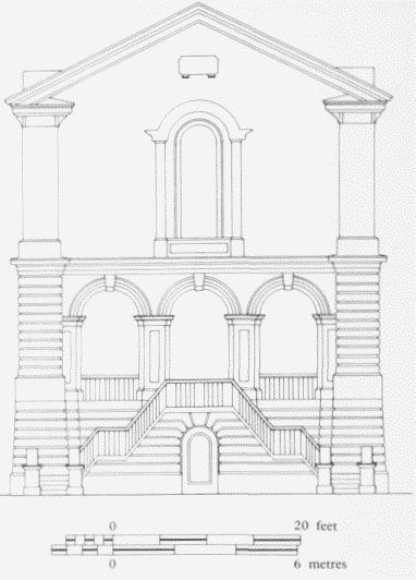
United Methodist Free Church, East India Dock Road,front (east) elevation to Poplar Bath Street. T. E. Knightley,architect, 1854. Demolished
In submitting this design to the Metropolitan Buildings Office, Knightley stressed the great depth of the gravel beneath the site, and the strength of the clasping buttresses, of the iron girders and columns supporting the floor of the church, and of the framing of the roof. (fn. 115)
For some reason this design was replaced by another three months later, radically different in so far as the church itself was shortened and the school separately accommodated at the west end: the round-headed style survived, however. This design was executed in 1855, by J. & J. Coleman of Bermondsey. (fn. 116)
The church flourished and in 1862 the site was enlarged by the acquisition of the piece of ground on its north side, evidently to permit the replacement of the recently built chapel by a bigger one. (fn. 117)
Knightley was not re-engaged and in December 1864 a competition was announced for the design of a new chapel and school here, to accommodate 1,500 worshippers and to cost £2,500 at most. (fn. 118) By March 1865 the chosen architect, Thomas Simpson of Nottingham, was inviting tenders, the lowest, however, coming in (from Ring & Wainman of Kennington) at £5,120. (fn. 119) The foundations were put in, more tenders were invited in December 1865 and on 1 January 1866 the shipowner Henry Green laid the foundation stone. (fn. 120) By September 1868 the church was complete. (fn. 121) No builder was named, although all the work was said to have been 'done by tender': perhaps this meant it was divided into separate contracts, to reduce the cost to the reported total of 'more than £4,000'.
The acquisition of the frontage directly on East India Dock Road in 1862 had allowed Simpson to design a wider church, and his block plan, although oriented eastwest like Knightley's, extended into the greater width available at the west end. The arrangement was, like Knightley's first design, with a school below and a galleried chapel above. (fn. 122)
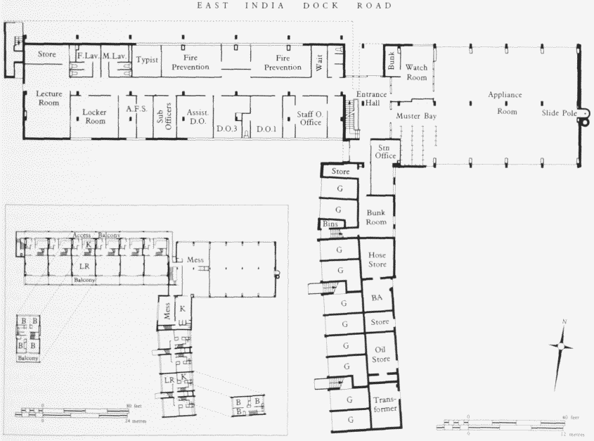
Poplar Fire Station, East India Dock Road, plans of ground and upper floors. GLC Department of Architecture & Civic Design, 1967–70 A.F.S. Auxiliary Fire Service: BA Breathing Apparatus: D.O. Divisional Officer
The walls were of white brick supplied by Messrs Pease of Darlington, but with polychromatic brick arches to the round-headed window- and door-openings, and plentifully dressed with Hollington stone (Plate 19a, b). The window-openings contained iron-framed casements, round-headed and mostly coupled in a South-Kensington manner rather at odds with the plethoric Ionic and Composite of the orders controlling the façades. The rearward aspect dispensed with architecture as blatantly as the back of a 1930s cinema. (fn. 123)
It was commented that of the 1,600 seats a 'liberal portion' was 'devoted to the poor': presumably, therefore, most were not free. (fn. 124) (In 1859 the 17 members of the church who were parties to a land-transaction consisted of one 'gentleman' and 16 tradesmen, of whom five were shipwrights.) (fn. 125)
In 1919 the church was acquired by the Poplar Methodist Mission a few doors westward, and was utilized for the vigorous 'social' campaigns of the superintendent minister of that church, the Reverend W. H. Lax. His work was countenanced by King George V, and the church, after a very expensive conversion by the engineers B. Finch & Company of Belvedere Road, was reopened as King George's Hall in 1920 by the Duke of York. A 'sub-ground floor' accommodated a men's club and recreation room, the ground floor a Sunday School and 'church work', and the top floor a concert hall. It all cost £36,000, to which one donor contributed £10,000. The architect was the Methodist, Josiah Gunton. (fn. 126)
The hall was licensed for cinematographic use, and an advertisement of 1923 announced the showing of D. W. Griffiths's 'Way Down East' with 'Special Musical Effects at every Performance direct from Empire Theatre London'. (fn. 127) The hall was damaged in the Second World War and its site taken into that of the Fire Station built in 1967–70.
Poplar Fire Station
A new divisional fire station to replace the existing ones at Brunswick Road, Bromley, and Burdett Road, Bow, was planned in the mid—1960s and built by the GLC in East India Dock Road in 1967–70. The site, of approximately 0.75 acre, was made up partly of land owned by the GLC that was originally allocated for housing, and partly of derelict properties. (fn. 128) The northern end of Cottage Street was closed and incorporated in the site in order to provide sufficient frontage on East India Dock Road. (fn. 129)
The building was designed by the GLC's Department of Architecture and Civic Design. In 1967 the construction contract was awarded to J. & J. Dean of Redbridge. The station was opened in August 1970, having cost almost £330,000. (fn. 130)
The station is of three storeys, with a flat roof, finished in brick and concrete (Plate 24d). It contains an appliance room for eight vehicles in four bays, accessible from both sides of the building through folding doors, with a control centre in the basement (fig. 54). As a divisional station it also has office accommodation and a lecture room. The upper floors contain mess, recreation and bunk rooms, and there are ten maisonettes for senior officers and firemen. A seven-storey drill tower stands in the yard to the rear of the building.
Poplar Baths
The implementation of the Baths and Wash-Houses Acts of 1846–7 in Poplar began in 1850, when the necessary requisition from the ratepayers was followed by the election of commissioners. (fn. 131) They appointed Price Pritchard Baly as their architect and examined his bath and wash-house buildings in St Martin's-in-the-Fields, Goulston Square, Whitechapel, and Marshall Street, Westminster. (fn. 132) Acquisition of a site was delayed slightly until the commissioners, initially appointed by the Trustees acting under the 1813 Improvement Act, were elected by the members of the vestry as required by the Acts of 1846–7. (fn. 133)
The site was at the north-eastern corner of Black Boy Field, 40 yards square, set slightly back from, and at an angle to, East India Dock Road. (fn. 134) It was bought from James Griffiths for £1,279 3s 4d. (fn. 135)
Baly's plans had been completed by the time that the site was secured. Robert & Edward Curtis of Stratford were awarded the building contract on their tender of £6,542. (fn. 136) The boilers, pipes, drying furnaces and apparatus were supplied by Samuel & William Standing of Whitechapel. (fn. 137) The building was opened on 17 July 1852, having cost £10,395. (fn. 138)
Baly's design used the whole of the site (fig. 55). (fn. 139) On the East India Dock Road frontage was a two-storey central block of five bays, flanked by single-storey ranges, with a symmetrical façade (Plate 26a). (fn. 140) The building was described as 'of Italian character' and was thought to be 'quite an ornament to the neighbourhood'. (fn. 141) Its bathing facilities were divided into two classes, with separate entrances, the first-class occupying the eastern side of the building. In each of the side ranges there was a plunge bath 42ft long and 26ft wide, with the dressing boxes placed at the ends. The slipper baths section, behind the entrance hall and staircase, contained 6 baths for women in each division, 12 in the men's first-class section and 24 in the second-class. The steam and shower bath areas were behind the slipper baths and the laundry was placed at the rear of the building, occupying its entire frontage on Arthur Street. The laundry contained 48 separate wooden washing tubs, drying equipment and ironing rooms. (fn. 142) The uncovered water tank, which was erected over the boiler house, had a capacity of 24,000 gallons. (fn. 143) From the boiler house, the chimney-stack, which was encased in a tower, rose through the centre of the building. (fn. 144)
An extensive overhaul of the building was needed by the mid-1880s. The changed requirements of the users of the baths made it desirable that a larger swimming pool should be available, with provision for spectators. This was achieved by reducing the area occupied by the laundry, thereby providing space for the creation of a new first-class pool by the extension of the second-class one to a length of 75ft. The slipper bath section was also remodelled. One of the defects of Baly's design had been the inadequate ventilation of the wash-house area. The roof had deteriorated and what was virtually a new roof, with a steeper pitch, was constructed and a light roof was erected over the water tank. (fn. 145) Two new Cornish boilers were installed at a cost of £948 6s 8d and the original ones were repaired and adapted as hot-water cisterns, erected on iron girders in the upper portion of the boiler house. (fn. 146) The opportunity was also taken to improve the drainage from the building. (fn. 147) These alterations were carried out in 1886 by John Walker to Messrs Clarksons' designs and cost £6,966. (fn. 148)
It was soon apparent that the capacity of the laundry was insufficient and in 1898 some structural alterations were made in that part of the building. (fn. 149) Mechanical washing machines and other equipment were installed in 1923 in the area previously occupied by the second-class bath, which was filled in. (fn. 150) Because of the unsatisfactory condition of the whole building, and the need to reconstruct and enlarge the bathing facilities, the wash-house section of the Poplar baths was transferred to a new building which was completed in Sophia Street in 1931 (see page 172). (fn. 151)
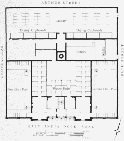
Poplar Baths, East India Dock Road, plan. PricePritchard Baly, architect, 1852. Demolished
Defects in both the internal design and fittings and of the structure itself became increasingly apparent during the 1920s and it was eventually decided to erect a new building. (fn. 152) In 1929 Harley Heckford, the Borough Engineer and Surveyor, was appointed as the architect. (fn. 153)
The site was enlarged by the acquisition of the adjoining properties, Nos 1–6 Grove Villas, No. 1 Bath Street and Nos 1–2 Arthur (now Lawless) Street. Agreement was reached with the tenants of No. 172 East India Dock Road for their temporary accommodation elsewhere while the new building was being constructed. (fn. 154)
The fabric of the new building was completed early in 1933, but, because of various delays in its fitting and furnishing, it was not opened until 20 January 1934. (fn. 155) The cost of the building, machinery and furnishings was £124,421 and a further £5,542 had been expended on enlarging the site. (fn. 156) The contractors were A. E. Symes of Stratford East. (fn. 157) The steel frame of the structure is clad in concrete, the exterior being faced with grey bricks. The decision to erect a symmetrical façade fronting only the main bath hall unbalanced the street frontage, so that the remainder of the building appears to be a later addition, when in fact the whole was a single design (Plate 26b). The large bath hall has a stepped roof with clerestory lights carried by seven elliptical arched ribs which were supported by horizontal beams spanning the length of the hall and held by tie beams at each end (Plate 26c; fig. 56). (fn. 158) The architect was praised for the up-to-date internal designs and the decorations, while the exterior was described as 'restrainedly modern'. (fn. 159) The local reaction to the building's appearance was much more critical, however, and it was dubbed 'Poplar gaol'. (fn. 160)
The two swimming pools were the predominant features of the new building. The larger one was 100ft long and 39½ft wide, with 23 men's and 21 women's changing cubicles respectively on its eastern and western sides, and a further 14 'collapsible' ones under the platform at the southern end. The smaller one, which until 1966 was known as the second-class pool, was 64½ft by 25ft, with 31 changing cubicles. On the first and second floors were 86 slipper baths; 44 of them for men and 42 for women, divided equally between the first—and second-class divisions. The basement contained a vapour suite, which included a plunge bath, a lounge with a buffet and a waiting room. Power was generated by two Lancashire boilers, each 28ft long with a diameter of 7½ft, and the boiler room also contained the six filter chambers. The cold water tank had a capacity of 35,000 gallons and was placed on the flat roof of the slipper bath ranges. (fn. 161)
Designated the East India Hall, the larger pool was floored over and used for other purposes during the winter months, when the smaller one remained in use. The hall was designed for conversion as a theatre with a seating capacity of 1,400, dance hall, cinema, exhibition room and sports hall, especially for boxing and wrestling programmes.
In 1935 a foam bath suite was installed in a part of the area occupied by the vapour suite. (fn. 162) In 1937 Messrs Windrum, auctioneers and surveyors, vacated the office accommodation at No. 172, in the north-eastern corner of the building. The opportunity was taken to expand the foam baths into the basement area of that unit. (fn. 163) The cost of conversion and equipment was £2,784. (fn. 164) From 1938 until 1941 the office was used by the staff of the Borough's electricity undertaking, while the showrooms at Nos 208–212 East India Dock Road were being rebuilt. (fn. 165) It was then occupied by the Transport and General Workers Union and the Poplar Labour Party. (fn. 166)
Wartime bomb damage forced the closure of the main bath hall, which remained unglazed for several years and was not reopened until 1947. Other reinstatement of war damage was executed in the early 1950s. (fn. 167) In 1985 the foyer ceiling was decorated with three murals, executed by David Bratby, with the history and function of the baths as their theme. (fn. 168)
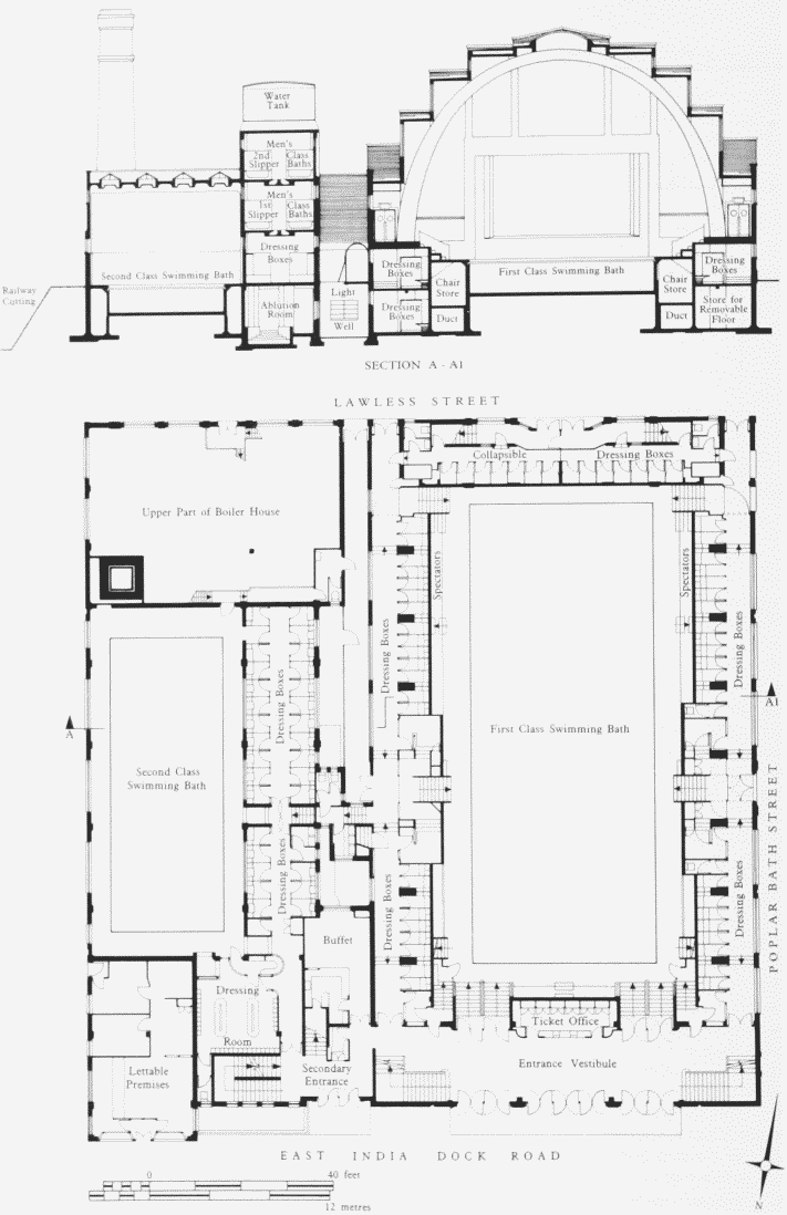
Poplar Baths, East India Dock Road, section and plan. Poplar Borough Council(Harley Heckford, Borough Engineer and Surveyor), 1933–4
In the first four years of operation the baths attracted an average of almost 273,000 users each year, in addition to those attending dances and other events in the hall during the winter season. (fn. 169) Post-war usage was somewhat less; between 1954 and 1959 they were used by an average of 225,700 bathers each year. (fn. 170) The numbers of dances also declined, reflecting a change in the type of demand for events in the East India Hall. (fn. 171) A wider range of sports facilities was provided; in 1956 cricket nets were installed and in the 1960s five-a-side football, indoor bowls and basketball were introduced. (fn. 172) The baths ceased to provide for these activities in 1980 when the seasonal conversion of the large pool into a hall was ended, as alternative indoor sports facilities had become available in other buildings. (fn. 173)
Usage of the baths continued to decline. Between 1966 and 1970 there was an annual average of 209,324 bathers using all sections, but during the period 1980–4 the comparable figure was 106,431. The numbers using the slipper baths also fell, to the extent that those on the second floor, which were in poor repair, were removed (fn. 174) and the space vacated was converted into a music studio, which was completed in 1984. (fn. 175) The remainder of the warm baths section was closed in 1985 and in the following year the large pool was closed for structural repairs to the roof. (fn. 176) It was not reopened and, because of the costs of the necessary repairs to the building, the entire baths services were terminated in 1988. (fn. 177) By then it was apparent that the earlier unfavourable opinions of the building had changed markedly, at least in specialist architectural circles, with Piers Gough describing it as 'a stunning building with its Hollywood style interior and beautiful vaulted ceiling'. (fn. 178) The building subsequently was adapted as an industrial training centre, with financial support from the London Docklands Development Corporation.
Statue of Richard Green
In front of the former baths is a bronze statue of Richard Green, philanthropist, shipbuilder and shipowner at Blackwall Yard, who died in 1863. It was executed in 1865–6 by the sculptor Edward W. Wyon (1811–85), who had already produced a bust of Green. The bronze casting, thought 'very fine', was carried out at the Southwark foundry of Henry Prince & Company. The wellcomposed figure shows Green, whose features were modelled from a death-mask, seated with his Newfoundland dog at his knee (Plate 26b). The group is placed on a high pedestal of granite, on the sides of which are bronze bas-reliefs, one of a Green ship and the other of ships building at Blackwall Yard. The statue was unveiled in May 1866 and it is that year-date, not the year of Green's death, that is on the pedestal. (fn. 179)
Poplar Railway Station (demolished)
This was built for the North London Railway Company in 1865–6, replacing its former station in Poplar High Street, to plans by the company's engineer, Thomas Matthews. The builder was G. J. Watts of Orchard Street, Poplar, and the estimated cost was £5,630. (fn. 180)
The station building was directly over the throughline, a siding terminating on its west side, under a flat roof. A view in 1904 shows the brick single-storey building, presenting a sequence of round-headed openings to East India Dock Road, under a crowning parapet that broke upward over the greater part of the front. (fn. 181)
The station was closed to passenger traffic in 1945. (fn. 182) The site now accommodates the All Saints station of the Docklands Light Railway.
All Saints' Church and Rectory, see page 176
Nos 174–238 (demolished)
The property east of Bow Lane was acquired by the East India Dock Company in 1804 (see page 576). (fn. 183) It sold it off soon afterwards and development shortly took place here, so that Horwood's map of 1813 could already show two groups of houses, at Nos 174–178 and at Nos 184– 196. The continuous development eastward of No. 184 shown on Greenwood's map of 1824–6 was, however, anticipatory.
Nos 174–182.
The westernmost three of these houses, Nos 174–178, originally Nos 1–3 Pekin Place, were some of the first houses built in the road, about 1808, and are shown in a photograph of c1924 (Plate 28b). (fn. 184) The builder was a carpenter in Bow Lane, Philip Caley, to whom the site was conveyed outright, not leased, by the East India Dock Company in 1808. Joined with Caley in the transaction was the road's surveyor James Walker, who in 1810 took a 14–year lease from Caley of No. 174 and lived there until 1816, looking out on to the road he had engineered. The Ralph Walker who was living in one of these houses, probably No. 178, in 1821 3 was doubtless the East India Dock Company's engineer, and James Walker's uncle. (fn. 185) The aspect of these houses might, therefore, be taken as in some sense indicating the 'best standard' thought appropriate in the road.
The three houses, set back behind areas, were three storeys high over a basement. The door-openings were round-headed, the broad, reeded architrave being carried over the arch unbroken save for small impost-blocks and a keystone. The window-openings had flat gauged arches, those of the first floor rising from an unmoulded sillband. At No. 178 a sunk panel below the central secondfloor window was incised PEKIN PLACE. To judge from No. 176 these second-floor windows may all originally have been square. The plain fronts were finished with a small coping.
No. 180, with slightly higher storey-heights, was probably built in 1838–40. (fn. 186) The tailor's shop-front glimpsed in the photograph was inserted in 1911. (fn. 187) No. 182, the Eagle Tavern, was built in 1859–60 for the occupant of No. 180, a rigger, to designs by the architects John Morris & Son. The builder was G. J. Watts, also a local man, who had tendered at £1,147. (fn. 188)
Nos 184–196
The six houses Nos 184–194 were built on land bought from the East India Dock Company in 1808 by Simon Kingsell of Poplar, 'gentleman' (in fact a house-painter, bankrupt in 1816) and his trustee, a coachbuilder in Long Acre. (fn. 189) A month or two later they sold part of the site for £220 10s to a William Strong (and his trustee)—Strong probably being an acquaintance in trade, as he was a varnish-maker in Longacre. (fn. 190) The rest they sold, for £113, to Thomas Burford, a stationer of Ratcliff Highway. (fn. 191) In 1810, however, Burford sold this part to Strong. (fn. 192) Building then proceeded—of Nos 184– 188 by February 1811 and of Nos 192 and 194 by September 1812. The houses were called Strong's Buildings from the beginning but the actual builder was evidently William Blackburn of Humberstone Street, carpenter, who was party to the 99–year leases which Strong granted of the houses to non-resident lessees with addresses in the Minories and Lombard Street. One of these leases, of Nos 192 and 194, brought in some £467, but none of it went to Strong or Blackburn: some went to Strong's mortgagee and the rest to Blackburn's assignees, for by 1812 he, too, was bankrupt. (fn. 193) In 1857, however, No. 190 was owned by a Charles Strong of Jewin Street in the City. (fn. 194)
In 1841 the occupants included an independent lady, a cowkeeper, a coppersmith, a lodging-house keeper and a shipwright. (fn. 195) A glimpse of Nos 192 and 194 in a photograph of 1912 shows plain brick fronts, the windowopenings having flat gauged arches. (fn. 196)
No. 196 had been built by 1822 on land sold in 1808 by the East India Dock Company to a Deptford pilot. (fn. 197) It was probably rebuilt in 1862 for a bellows-maker, with a 'warehouse' door at first-floor level. (fn. 198)
The Ladbroke Social Club at Nos 192–200
This building, latterly a bingo hall, was demolished in 1989. Until the 1960s it had been a cinema, the Poplar Pavilion, originally established at Nos 192 and 194 in 1912. The architect was Frank E. Harris of the Mile End Road, evidently for J. M. Rothstein (for whom Harris also designed a cinema at No. 221 Westferry Road), whose family retained ownership throughout the cinema's history. (fn. 199) It was advertised as 'accessible, select, superbly upholstered' and, exacting only 3d for admission, soon proved too small. (fn. 200) In 1914, therefore, it was reconstructed, and widened to take in the site of No. 196, by J. W. Jerram of East Ham, to designs by the architect J. M. H. Gladwell. The facade, evidently of stone, was quite restrained, except where it swept up to two segmental-topped quasi-gables. A publicity leaflet spoke of the 'fine proportions' of the interior (where the plaster decoration was by Messrs Boekbinder of Kentish Town), the 'fine balcony', the good heating and ventilation and 'the largest Fire-proof Screen to be seen in London Cinemas'. (fn. 201) The enlarged cinema was opened in November 1914 by the Mayor of Poplar. (fn. 202) In 1926 it was again reconstructed and enlarged, with the orientation turned eastward, to take in the former sites of Nos 198 and 200. The architect was A. H. Jones of Victoria Station House and the builder F. E. Little of Tottenham. The seating capacity was doubled, to some 1,350. (fn. 203) More changes in 1927–8 introduced 'continuous performances' and a 'Grand Organ'. An unobstructed view of the screen, often promised before, was promised again, 'very soon'. (fn. 204) The cinema was badly damaged by a V2 rocket in March 1945. (fn. 205) In 1953 a 'wide screen' was introduced—claimed to be the first in East London. (fn. 206) The cinema closed, as the Essoldo, in about 1967. (fn. 207)
Nos 198–202
Between No. 198 and Robin Hood Lane lay the part of Coachman's Field sold by the Wells family to Ashton and Hale in 1807 (see page 190). The latter sold the house-sites from 1808 onwards, probably without building much if anything on the road frontage.
Nos 198–202 were built about 1822, perhaps by the Poplar builder William Moore, who bought the site of Nos 198 and 200 from Ashton and Hale in 1818 and 1822. (fn. 208) The nineteenth-century appearance of No. 202 was produced by a reconstruction that was carried out as late as 1913. (fn. 209)
No. 202A
This was the Falcon beerhouse or public house from at least 1869. (fn. 210) In 1911 a new building was erected by W. Pringle of Bow for Truman, Hanbury & Buxton, to designs by B. J. Capell, architect. (fn. 211) It was extended southward by the same builder, to include a dining-room, in 1924. (fn. 212) In 1972 the saloon bar and the large public bar were switched round, to cater for 'the family' rather than dock-workers. (fn. 213)
The first building on the site was erected about 1819, under the leasehold ownership of a Poplar wine merchant, Thomas Pattenden. (fn. 214) In 1829–31 it and houses southward in Union Place were briefly in the hands of Thomas Flight, an 'esquire' of Bond Court, Walbrook, (fn. 215) whose later property dealings in London did not give him a good name.
Nos 206–212
These four houses were built about 1860. The entrepreneur applying to the local authority in 1856 was the successful shipbuilder T. J. Ditchburn, of No. 153, but progress was not brisk. (fn. 216) Nos 210 and 212 were not occupied until 1859–60 (fn. 217) and Nos 206 and 208 are not shown on the Ordnance Survey map of 1867–70.
The site, sold by Ashton and Hale to Simon Kingsell in 1807–11, had one detached house on it by 1813, occupied in 1832–51 by the surgeon F. H. Beall. (fn. 218) Electricity Showrooms and Offices. In 1934 Poplar Borough's Electricity Undertaking moved into showrooms at Nos 210 and 212 East India Dock Road. The showrooms had a central island display window, two side windows and two entrances. The upper floors were used as offices. (fn. 219) Within two years it became apparent that the accommodation was unsatisfactory; queues of customers were so long that they extended on to the pavement from time to time, and difficulties were encountered with the loading and unloading of vehicles in front of the building. (fn. 220)
The site was extended by the purchase of No. 208, and Nos 30–31 Ashton Street, to the rear, for £2,550. (fn. 221) The plans for the new building were signed by Rees Williams, the Borough Engineer and Surveyor, and A. E. Williams, Architectural Assistant. (fn. 222) In 1938 the buildings on the enlarged site were demolished and work began on the new showrooms and offices. (fn. 223) It was carried out by the Borough's direct labour force. (fn. 224) The building was completed by January 1940–although the shop front was bricked up as an air-raid precaution. (fn. 225) In 1938 the estimate allowed £39,200 for the cost of the buildings, furnishings and equipment, with a further £1,576 for architectural services. (fn. 226)
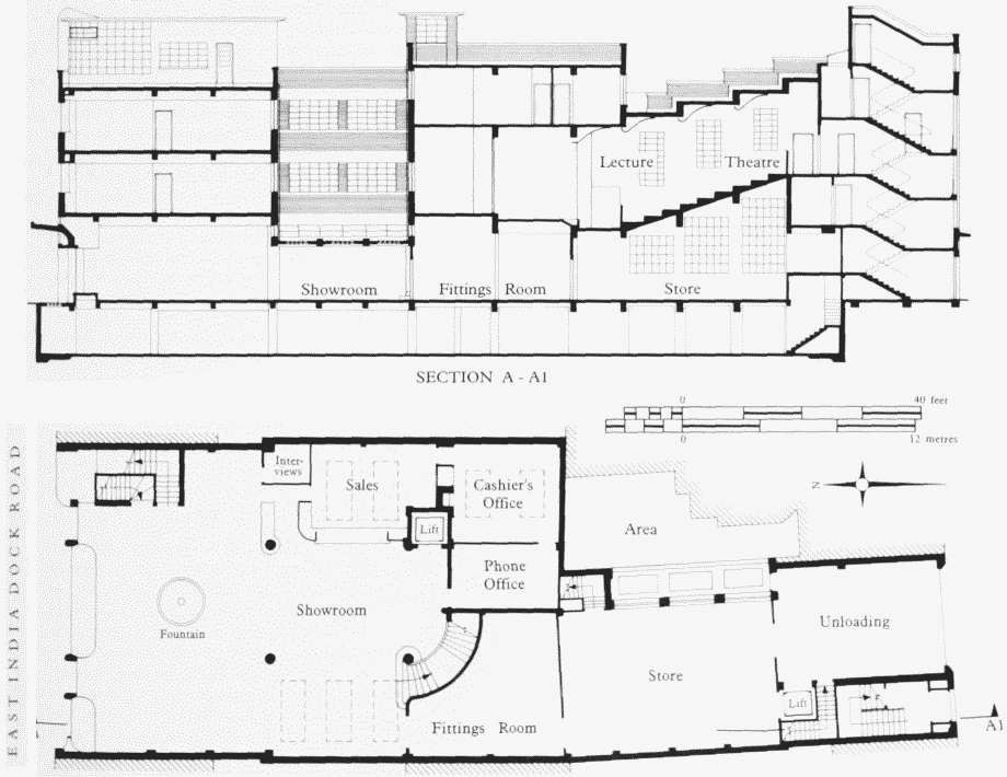
Electricity Showrooms and Offices, Nos 210–212 (even) East India Dock Road, ground-floor plan and section. Rees Williamsand A. E. Williams of Poplar Borough Council, architects, 1938–40. Demolished
The building's accomplished Modern-style design gave it a distinctly Odeonesque appearance. It was of three storeys with a flat roof broken by lift and stair towers (Plate 24b; fig. 57). Showrooms occupied the ground floor at the front of the building, with stores to the rear, which had loading bays in Ashton Street. The rear of the first and second floors was occupied by a tiered lecture theatre seating 108, with a stage and projection facilities. A demonstration kitchen adjoined the lecture theatre. Office and other administrative accommodation was placed on the remainder of those floors. The basement, containing storage space and heating plant, was approved for use as an air-raid shelter holding up to 238 persons. (fn. 227)
In 1963 the London Electricity Board converted the upper floors into an operations training centre, providing courses for showroom staff, demonstrators and sales representatives. The showrooms remained in use until 1972 and the training centre was closed in 1975. (fn. 228) The building was subsequently sold and used for commercial purposes. It was demolished in 1991.
Nos 214–238
. The site at No. 214 was occupied from about 1839 by Albion House, the first occupant being the shipbuilder T. J. Ditchburn. (fn. 229) It was in a lateGeorgian style, rising three storeys above a basement behind an area, its plain brick front finished with a small coping (fig. 58). The door-opening and ground-floor window-openings were round-headed, the latter fitted with Gothick-glazed sashes, and it had a high-placed name-tablet. In these respects it was similar to the slightly later Nos 237 and 239, but here there were two groundfloor windows, and the first-floor windows were furnished with a continuous balcony guarded by a conventionally 'Rococo' iron balustrade. (fn. 230)
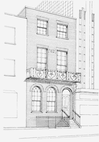
No. 214 East India Dock Road (AlbionHouse), sketch elevation.Demolished
The first building on site at No. 216 was erected in about 1814, with lower storey-heights than No. 214, and it was given a ground-floor bay window in 1873. (fn. 231)
The site of Nos 218 and 220 was sold by Ashton and Hale to John Dixon, a 'gentleman' of Blackwall, and was built upon in 1824–5. (fn. 232) The two houses were altered at an unknown date. Nos 222 and 224 were slightly earlier, being built probably about 1818–19. (fn. 233) The first house at No. 226 was originally built about the same date, perhaps by Thomas Lambert of Naval Row, builder, but was replaced in 1938. (fn. 234)
No. 228 was probably originally built about 1823–4, but Nos 230–234 were of about 1846–7, No. 230 being rebuilt in 1921. (fn. 235) No. 236 was built in 1876, partly over the former entrance to Burford's Court, which it shared with the beerhouse southward in Robin Hood Lane that was sometimes numbered 238 East India Dock Road. This last, the Volunteer public house, was rebuilt in 1913 for Charringtons by Griggs & Son of Manchester Road to designs by C. Gordon Smith of Cannon Street. (fn. 236)
Nos 218–224 and 228–234 were the last of these buildings to be demolished, surviving until 1991.
For the south side of East India Dock Road east of Robin Hood Lane see Chapter XX.