Survey of London: Volumes 31 and 32, St James Westminster, Part 2. Originally published by London County Council, London, 1963.
This free content was digitised by double rekeying. All rights reserved.
'Plate 152: PICCADILLY CIRCUS AREA', in Survey of London: Volumes 31 and 32, St James Westminster, Part 2, ed. F H W Sheppard (London, 1963), British History Online https://prod.british-history.ac.uk/survey-london/vols31-2/pt2/plate-152 [accessed 11 May 2025].
'Plate 152: PICCADILLY CIRCUS AREA', in Survey of London: Volumes 31 and 32, St James Westminster, Part 2. Edited by F H W Sheppard (London, 1963), British History Online, accessed May 11, 2025, https://prod.british-history.ac.uk/survey-london/vols31-2/pt2/plate-152.
"Plate 152: PICCADILLY CIRCUS AREA". Survey of London: Volumes 31 and 32, St James Westminster, Part 2. Ed. F H W Sheppard (London, 1963), British History Online. Web. 11 May 2025. https://prod.british-history.ac.uk/survey-london/vols31-2/pt2/plate-152.
In this section
Piccadilly Circus Area
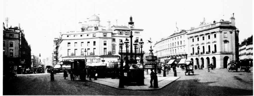
a. View before 1884 showing (left to right) Swan and Edgar's, County Fire Office, Glasshouse Street, and houses later removed for formation of Shaftesbury Avenue (p. 85).

View before 1884 showing (left to right) Swan and Edgar's, County Fire Office, Glasshouse Street, and houses later removed for formation of Shaftesbury Avenue (p. 85).
Demolished
b. Piccadilly Circus in 1909 (pp. 85–7).
Piccadilly Circus in 1909 (pp. 85–7).
Demolished