Survey of London: Volume 23, Lambeth: South Bank and Vauxhall. Originally published by London County Council, London, 1951.
This free content was digitised by double rekeying. All rights reserved.
'Prince's Meadows', in Survey of London: Volume 23, Lambeth: South Bank and Vauxhall, ed. Howard Roberts, Walter H Godfrey (London, 1951), British History Online https://prod.british-history.ac.uk/survey-london/vol23/pp12-17 [accessed 29 April 2025].
'Prince's Meadows', in Survey of London: Volume 23, Lambeth: South Bank and Vauxhall. Edited by Howard Roberts, Walter H Godfrey (London, 1951), British History Online, accessed April 29, 2025, https://prod.british-history.ac.uk/survey-london/vol23/pp12-17.
"Prince's Meadows". Survey of London: Volume 23, Lambeth: South Bank and Vauxhall. Ed. Howard Roberts, Walter H Godfrey (London, 1951), British History Online. Web. 29 April 2025. https://prod.british-history.ac.uk/survey-london/vol23/pp12-17.
In this section
CHAPTER 1 - PRINCE'S MEADOWS
Prince's Meadows was the name given to the detached portion of the demesne land of the manor of Kennington lying at the northern end of the parish between Broadwall and the site of Waterloo Road, inside the Narrow Wall.
The river front, being reclaimed land, was not considered to be part of the Meadows but was known as“waste.” It was, however, only the“waste” which is shown to have buildings on the 1636 survey of the manor (Plate 1). There the river front is indicated as having been“campsheathed,” i.e., protected by a wall of timber and the sloping ground of the foreshore inside it made level. Several houses and a crane are shown near the parish boundary, while the remainder of the“waste” is marked as timber yards or osier beds. The Meadows are divided into two. They appear to be entirely unbuilt on and are surrounded by watercourses.
In the reign of Henry VIII, William Baseley, who owned the manor of Paris Garden (now roughly coincident with the parish of Christ Church) and ran a gaming house there, (fn. 10) obtained a lease (fn. 3) of marshland being part of Kennington Manor. This was almost certainly Prince's Meadows, but the name does not seem to have come into use until later, the first documentary reference to it that has been found being in Norden's Survey of Kennington made in 165. (fn. 5)
In the Prince's Meadows area Norden listed a “meadow called Princes Mead” containing 25 acres and let to William Page, an osier ground adjoining the river next to Prince's Mead containing 4 acres and let to John Johnson, John Olife and Robert Robinson, and half an acre of ground with a wharf let to William Smythe. He also included a piece of copyhold land with buildings“formerly Cockerhams” containing 11/2 acres, lying next to the Thames and called the Corner Meadow in the marsh known as Prince's Meadow, and added the note that though this was claimed by Ralph Hanmer, gentleman, de jure, he was not in possession, and the tenant was of the opinion that the land belonged to the manor of Paris Garden. (fn. n1)
Paris Garden was almost entirely surrounded by the Pudding Mill Stream, but it is obvious that by the beginning of the 17th century some doubt had arisen as to the exact boundary between it and Prince's Meadows near the river. The confusion probably arose over the King's (or Queen's) Barge House, which was, from the time of Queen Elizabeth, and perhaps earlier, near or over the sluice from Pudding Mill Stream into the river. In 1636 Harbord (fn. 6) stated that the Earl of Arundel held 2 “lowe meadowes Iyeing together called the Prince's Meades” containing nearly 23 acres, “a wharfe strongly built called the Cittie Wharfe” and another new wharf “lyeing between the Erle of Arundell his garden and the Thames adjoyning to the Sluce.” Harbord was doubtful whether this last wharf should have been included within the manor or not, and even more so about the wharf and timber yard in the tenancy of Jeremy Crewe, on which half the King's Barge House stood, and the wharf and timber yard in the tenancy of Katherine Strikeley, widow, on which a number of houses and cottages stood. Harbord noted that Norden had described the manor of Kennington as extending to the decayed common sewer, then “not used and partly filled up’ on the mouth of which the King's Barge House was situated. A plan, a part of wnich reproduced here, of the northern part of Paris Garden at about this date shows the King's Barge House and the land referred to by Norden as the Corner Meadow included within that manor. As at that time the Earl of Arundel was in possession of the land on both sides of the boundary the matter was perhaps not considered to be immediately important.
In 1660 Sir Charles Harbord reported that the site of the old Barge House erected by Queen Elizabeth “is confessed to be his Majestie's ground,” but that the rest of the wharf was “detained from his Majesty” and the prospective lessee ought to try and recover the same “for his Majestie's use and benefit,” at his own costs. (fn. 8)
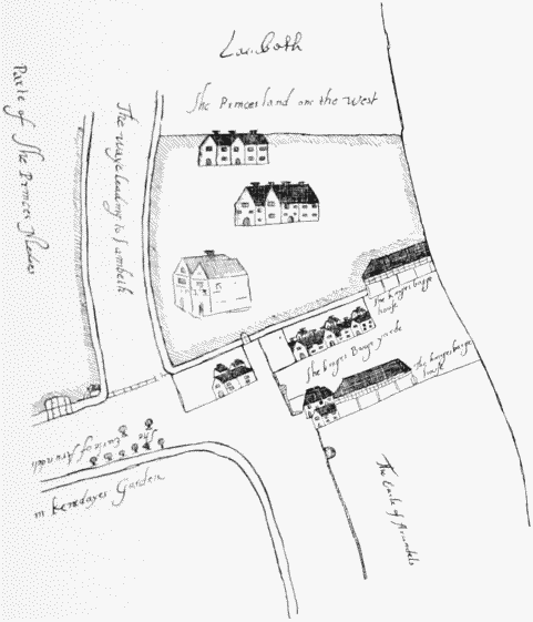
Part of plan of Prince's Meadows, 1636
It seems probable that the Barge House was originally built on land belonging to Kennington Manor, being royal property, and that the boundary between the manors ran along the sewer or sluice under the barge house, but that subsequently the mouth of the sluice which had marked the boundary was filled up and the boundary line diverted. Certainly the sites of the King's Barge House and Corner Meadow are now included within Christ Church parish though the small strip of ground west of the sluice on which one part of the King's Barge House originally stood is still considered to be a detached portion of the Duchy of Cornwall property.
In 1649 Daniel Goodersay was tenant of Prince's Meadows, and several wood yards are listed as lying along the river front, while Judah Walker held one little tenement in the north-east corner of the Prince's Meadows “consisting of three litle roomes wherein washing weomen live.’ (fn. 4) A further survey was made in the same year to decide whether the cranes and houses on two of the wood yards were tenants’ fixtures which might be removed at the end of their lease. It was decided that the dwelling houses were “soe fixed to the freehould and soyle … by strong sleepers of wood lying deepe within the ground and by other substantiall ground cills and foundacons, some of brick and others of wood” they ought not to be removed; but that the two cranes and a counting house stood on removable blocks and were the tenants' goods. (fn. 7)
In 1660 Harbord had to report (fn. 8) that during ‘the late usurped Authority’ many houses and wharves had been erected along the river bank by Prince's Meadows. William Dover held one dwelling house and about 11 acres of the meadows and ten small houses along the river bank; Boydell Cuper had 7 acres of the meadow and 13 small tenements; Fulke Morris had 6 acres of meadow; Henry White had 13 small cottages erected by him on part of the bank and a house and yard, part of the same wharf; Edward Smith had a house and yard on the same wharf and Thomas Shirley had a yard called City Wharf and some houses built there by Mr. Bassett, together with houses and yards held under him by one Sandon and Ralph Wilmot. Much of the ground was used for the washing and whitening of cloth.
He further reported that three barge houses had been recently erected there, one for the Lord Mayor, a second with a small cottage for the Merchant Taylors’ Company, and a third for the Woodmongers’ Company. There was some difficulty at this time in adjusting the claims of tenants who had spent money during the Commonwealth period in improving properties which at the Restoration reverted to the Crown. Harbord recommended that these tenants should be given leases before any general grant of the whole demesne was made. Among others the Lord Mayor and Commonalty of the City and the Merchant Taylors’ Company were granted leases (fn. 3) of their barge houses, and these remained in their tenancy until the beginning of the 19th century. The barge house of the Woodmongers was leased to them for 31 years, but the lease does not appear to have been renewed. (fn. 3) A lease of Prince's Meadows was granted to John Arundell in 1661.
In 1671 and again in 1676 John Arundell was granted renewals of his lease. In the latter year he sublet the ground to Richard Rawe. It was described in the lease as “meadows, wharves and osier grounds bounded on the north by the land called Le Banke and extending to the place where there is built a certain ruinous house called the King's Old Barge House towards the north, up to a certain parcel of ground lately of Henrie Earl of Arundel towards the west near the Sluice.” (fn. 3)
It was during Arundell's tenancy that some of the remaining fragments of the Arundel marbles from Arundel House in the Strand were dumped on the waste ground bordering Prince's Meadows. James Theobald has left it on record (fn. 11) that this ground was shortly afterwards let for a timber yard and that when the foundations for the new St. Paul's Cathedral were laid “great quantities of the rubbish were brought over thither to raise the ground, which used to be overflowed every spring tide; so that by degrees, those statues, and other marbles, were buried under the rubbish… and lay there for many years almost forgot and unnoticed.“ Theobald's father obtained a lease of this ground in 1712 and in digging foundations for new buildings came upon some of the fragments. These were dug up and subsequently some of them were acquired by the Earl of Burlington and sent to Chiswick House and some by the Duke of Norfolk and sent to Worksop. Theobald himself used some blocks of marble to put in his house, the Belvedere, a little farther up the river (see p. 51).
In March, 1699, Sir Francis Child was granted a lease of Prince's Meadows, excepting the barge houses, to commence from 1717, but in 1716 he assigned his interest to Richard Rawe of St. Columb, Cornwall. Richard Rawe died shortly afterwards, and in 1718 Frances his widow and Richard Agar of the Middle Temple were granted a lease of the site of the Wood-mongers’ barge house; this land is described as “lately part of a yard called Collyar's Yard, bounded by the Gates and Pallisadoes on the Thames Wall south.” (fn. 3)
In 1734 Mrs. Rawe and Richard Agar obtained a lease in their own right of the whole of Prince's Meadows, with the exception of the two barge houses, and in 1765 this was renewed to Mrs. Frances Rawe. At Mrs. Rawe's death her estate went into Chancery and Thomas Duck, the receiver appointed by the court, was granted a lease in trust for such persons as the court should direct, to commence from April, 1780. It is noteworthy that the fine for this renewal was £3,710 whereas at the previous renewal in 1765 it had been only £900. (fn. 3)
In the 1780 lease the King's Old Barge House site was stated to be in the tenure of Thomas Lowe Co., glass bottle makers, and the Wood-mongers' barge house site in the tenure of Margaret Eeles and Thomas Bond, timber merchants. (fn. 9)
In the Middleton survey of 1785 (fn. 9) there were stated to be 70 dwelling houses on Prince's Meadows with warehouses, dyehouses, storehouses, accounting houses, brewhouses, coachhouses, carthouses, stables, sawhouses, cranes, sheds, wharves, yards, gardens, fields, ponds and canals, containing in all nearly 29 acres. (fn. n2)
The 1799 edition of Horwood's map shows a large woollen cloth manufactory stretching south of Narrow Wall east of Beaufoy's Distillery (the site of Cuper's Gardens), the Patent shot works and timber yards along the river frontage, and a line of small houses along the south side of Narrow Wall.
In 1810, in view of the building of Waterloo Bridge and its approaches, an Act of Parliament was passed to enable the Prince Regent to grant leases of Prince's Meadows for 99 years from October, 1815, for the purpose of building a “town” to be called “Prince's Town.” (fn. 12) The state of the property at this time with the projected roads is shown on the plan on Plate 3. The whole property was leased to Thomas Lett and John Lett of Narrow Wall, timber merchants, for a fine of £55,100. (fn. n3) They developed some parts of the estate themselves but let the greater part on building leases in small plots.
Narrow Wall was widened to form Commercial Road, now Upper Ground, and Stamford Street was continued as Upper Stamford Street to Waterloo Road; while Duke Street, now Duchy Street, Princes Street, now Coin Street, and Cornwall Road, a continuation and widening of Green Lane, running north and south, were made across them.
Most of the houses were small and of little architectural interest. One of the largest commercial enterprises was the printing works of William Clowes, which occupied a considerable area of ground between Duchy Street and Coin Street. Clowes took over Applegath's works in 1821, (fn. 13) and the firm remained on the same site until the premises were bombed in 1941. (fn. 1)
The river bank was entirely given over to commercial purposes, timber yards, wharves, and the like. Of recent years two of the Metropolitan Borough Councils had dust destructors there, while on Bowater's Wharf the brothers Gatti had a generating station to supply light to the Adelphi Theatre in the Strand. (fn. 3)
The square shot tower, which stood east of Waterloo Bridge until 1937, had ceased to manufacture shot for a number of years, and was used as an advertising sign. It was built circa 1789 by Messrs. Watts. Samuel Ireland in 1791 (fn. 14) spoke of it as “a new structure … [which] cost near six thousand pounds, but cannot be considered as an object ornamental to the river Thames.” (Plate 6b.) It was about 150 feet high. In 1826, when it was owned by Messrs. Walker and Parker, the top part was destroyed by fire, but it was soon repaired and in use again. This shot tower was not the first of its kind to be built along the south bank. In 1758 Henry Raminger, of Christ Church, Southwark, had taken out a patent for the manufacture of lead shot, and a tower was built in that parish some years before the one in Prince's Meadows. (fn. 2) An account of the round shot tower south-west of Waterloo Bridge is given on p. 47.
A more detailed account of the development of Stamford Street is given in the next chapter.
The London Botanic Garden
Waterloo Junction and the streets immediately surrounding it stand on the site of the botanic garden opened by William Curtis in January, 1779.
The garden lay between Green Lane (now Cornwall Road) on the west and Broadwall on the east, while its southern boundary was the footpath known as Curtis's Halfpenny Hatch. Curtis's prospectus stated that subscribers of one guinea a year would be entitled to walk in the garden, use the library, and introduce one person; “the situation being low, renders it peculiarly favourable to the growth of aquatic and bog plants.” (fn. 15) Curtis continued his garden in Lambeth Marsh until 1789, and much of his Flora Londinensis was prepared during this period. The reasons for his removal of his plants to a new site in Brompton are best given in his own words: “I had long observed with … regret, that I had an enemy to contend with in Lambeth Marsh, which neither time, nor ingenuity, nor industry, could vanquish; and that was the smoke of London, which, except when the wind blew from the South, constantly enveloped my plants … In addition to this grand obstacle, I had to contend with many smaller ones … such as the obscurity of the situation, the badness of the roads leading to it, with the effluvia of surrounding ditches, at times highly offensive.
“Nevertheless, when I reflected on the sums I had expended, when I surveyed the trees, the shrubs, and the hedges which I had planted now become ornamental in themselves and affording shelter to my plants … I should have … continued my garden under all its inconveniences had not my landlord exacted terms for the renewal of my lease too extravagant to be complied with.” (fn. 15)
The Curtis family held leases of about 4½ acres from the Duchy of Cornwall (fn. 9) (fn. n4) and 1½ acres from Sir William East (lessee of the Archbishop of Canterbury). (fn. 16) It is probable that one or both were holding out for higher rent in expectation of building development in the neighbourhood though in fact this did not materialise until more than 20 years later.