An Inventory of the Historical Monuments in Westmorland. Originally published by His Majesty's Stationery Office, London, 1936.
This free content was digitised by double rekeying. All rights reserved.
'Yanwath and Eamont Bridge', in An Inventory of the Historical Monuments in Westmorland(London, 1936), British History Online https://prod.british-history.ac.uk/rchme/westm/pp250-255 [accessed 28 April 2025].
'Yanwath and Eamont Bridge', in An Inventory of the Historical Monuments in Westmorland(London, 1936), British History Online, accessed April 28, 2025, https://prod.british-history.ac.uk/rchme/westm/pp250-255.
"Yanwath and Eamont Bridge". An Inventory of the Historical Monuments in Westmorland. (London, 1936), British History Online. Web. 28 April 2025. https://prod.british-history.ac.uk/rchme/westm/pp250-255.
In this section
113 YANWATH and EAMONT BRIDGE (D.b.)
(O.S. 6 in. (a)III, S.E., (b)VII, N.E.)
Yanwath and Eamont Bridge is a parish on the N. border of the county immediately S.W. of Penrith. Yanwath Hall, Eamont Bridge, Mansion House and the remarkable earthworks of King Arthur's Round Table, Mayburgh and Castlesteads are the principal monuments.
Secular
a(1). Eamont Bridge (Plate 153) over the river Eamont, on the N. border of the parish, is a structure of rubble and ashlar of three spans with segmental arches. The piers have cutwaters with refuges above and the arches have square soffit-ribs. It was re-built probably in the 16th century and has been widened on the E. side, four of the ribs being old and two modern. The approach on the N. has been widened on both sides and the S. approach is modern.
Condition—Good.
a(2). Yanwath Hall (Plate 160), in the N.W. corner of the parish, is of two and three storeys; the walls are of rubble with some ashlar-facing and the roofs are slate-covered. The house forms three sides of a courtyard. The tower is said to have been built by John de Sutton in 1322 and to this date may belong the rubble-faced lower part; the range adjoining it on the E. may be partly of this date also, but only as far as the straight joint W. of the entrance. Early in the 15th century, when the house belonged to the family of Threlkeld, this range was largely re-built and extended towards the E. The E. range was built perhaps also in the 15th century. Early in the 16th century the property passed to the Dudley family when the upper part of the tower was re-built; the plaster-work and large windows in the second stage were probably inserted by Edmund Dudley in 1586. The N. and S. walls of the kitchen and the E. side of the E. range were re-built late in the 16th or early in the 17th century and about the same time the N. range was built. Various minor alterations were made in the 17th century and the house passed to the Lowther family in 1671.
The house is an important example of a mediæval and later semi-fortified building and contains some good plaster-work.
The Tower, at the S.W. angle, is of three storeys with a moulded plinth and an embattled parapet, carried up at the angles to form turrets. The N., S. and W. sides have each a 16th-century window, at the first floor level, of five transomed lights with a moulded label. The other windows are small square-headed openings except one on the W. which is a single 14th-century light with a trefoiled ogee head. The ground-storey of the tower has a segmental barrelvault of stone. The room on the first floor has a 16th-century fireplace with moulded jambs and triangular arch in a square head; above it is a plaster panel with the royal arms (Plate 50) of Queen Elizabeth. The ceiling has two intersecting moulded beams with nail-head ornament and a pendant (Plate 160) at the intersection, consisting of four free ribs and a boss; this is probably the ceiling that in Machell's time had three coats-of-arms and the date 1586; the E. wall has a cornice and a frieze with arabesque ornament. On the W. wall is a corbel carved with the bust of a man. In the N.W. angle is a garde-robe and there is a second on the floor above. The room on the second floor has an open 16th-century roof (Plate 160) of four bays with moulded tie-beams with nail-head ornament and embattled plates; the middle purlin has flat-curved braces. In the W. wall is a square-headed fireplace and above it are traces of painting on the plaster; the windows in the E. and S. walls have embrasures with seats; in the E. wall are two lockers; the entrance passage and the garde-robe have each a round bowl and drain. The S. front of the main block or S. range, has towards the W. end a 15th-century bay-window or oriel of the former hall; it is of three trefoiled and transomed lights in a square head; further E. is a second 15th-century window of two trefoiled lights; the other windows are mainly of the 16th or 17th century and include two, each of three transomed lights in a square head; the doorway to the former screens is probably of the 17th century and has a round head. The N. side of this range, has a 15th-century window of two trefoiled lights and a number of 16th and 17th-century windows; there is also a cruciform loop, towards the E. end, now blocked. The early 16th-century doorway to the screens has moulded jambs, round arch and label; it is fitted with a door with a form of linen-fold panelling and an elaborately traceried head. The return of the plinth of the tower for a short distance along this wall indicates the existence of an earlier range on the same site; the presence of a row of corbels on the tower below the existing roof of the range provides further evidence of this earlier building. Inside the range, the main part was occupied by the hall, with the screens at the E. end and the kitchen beyond. The hall has had a ceiling inserted and also some partitions. The 15th-century roof (Plate 29) is of three bays; the trusses have collar-beams and king-posts and curved and moulded braces below the collars, forming four-centred arches; the king-posts have foiled braces to the ridge and there are similar braces to the purlins. The screens are separated by a solid wall, probably a 16th-century insertion, and having a doorway with a four-centred head; on the W. face of the wall is a fireplace with a gallery, resting on a segmental arch, to the S. of it. On the W. wall of the hall is a late 16th-century clockface (Plate 58) of painted boarding; it has a dial with the sun and moon above and figures of men below; on a scroll is the motto "Sic transit gloria mundi"; flanking the main panel are two bands of conventional ornament. In a room on the first floor, W. of the hall, is a 16th-century fireplace with a square moulded head; the room has remains of a moulded plaster cornice. In the E. wall of the screens-passage is a late 14th-century doorway with a two-centred head; the door is old and has two heavy strap-hinges. The kitchen fireplace has a wide segmental arch. The E. range is probably of the 15th century but the E. wall, except for the ashlar-faced portion at the N. end, has been re-built in the 17th century. The range is crossed by an entrance-passage with modern openings at each end. In the W. wall are three 15th-century doorways with pointed heads. In the E. wall are some 17th-century windows and a doorway with moulded jambs and square head. The N. wall is ashlar-faced in its upper part and finished with a 16th-century embattled parapet, returned on corbels a short distance along the E. wall; this stands free above the roof of the range forming a sort of elongated turret. Inside the range is a fireplace with a four-centred head and above it a projecting mantel with a flat four-centred arch springing from corbels. There are remains of a roof of king-post type. The N. range is of late 16th or early 17th-century date. It retains a number of windows of this period and four doorways with segmental or four-centred heads. The cartway or entrance passage, crossing the range has a wide segmental arch at each end, of no great age. The roof, towards the E. end is original and has moulded principals and chamfered tie-beams and collars.
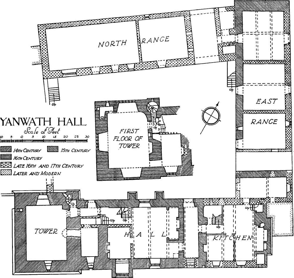
Yanwath Hall
Condition—Good.
a(3). Mansion House, now tenements, on the E. side of the road 200 yards S.S.E. of Eamont Bridge, is of three storeys. The walls are of rubble with ashlar dressings and the roofs are slate-covered. It is a complete and little altered building of 1686. The W. front is symmetrically designed with architraves to all the windows and cornices over the windows of the two lower ranges. The angles of the front are rusticated and in the middle is a porch (Plate 21) with a balustraded parapet; the outer doorway has two plain shields and the initials and date R. and L.B. (said to be for Roger Bradley, vicar of Brougham and his wife) 1686. The top of the porch forms a balcony formerly entered by a central doorway, now blocked; it has a moulded architrave and scrolled brackets supporting a cornice and a scrolled and broken pediment. The other elevations have original windows, most of them of the mullion and transom type. Inside the building the staircase is original, with heavy moulded handrails and newels with turned pendants; the lower flight has twisted and the upper turned balusters. In the N.W. room is a wide original fireplace, now blocked.
Condition—Fairly good.
Monuments (4–11)
The following monuments, unless otherwise described, are of the 17th century and of two storeys; the walls are of rubble and the roofs are slate-covered. Some of the buildings have exposed ceiling-beams.
Condition—Good or fairly good.
a(4). Cottage, on the W. side of the road 20 yards S. of Eamont Bridge, has a doorway with the inscription "Omne solum forti patria est. H.P. 1671" on the lintel; above it is a tablet of 1751.
a(5). Barn on the N. side of the road 900 yards S.W. of the bridge has a door-lintel with the initials and date F. and H.N. 1697.
a(6). Gate Green, house on the S. side of the road at Yanwath 620 yards S.E. of (2), has an addition of 1772 on the N.
a(7). Gate Inn, 70 yards W.S.W. of (6), contains a small cupboard with an enriched door. On a lintel are the initials and date R.L. 1689 (?).
a(8). The Green, house 140 yards N.N.W. of (7), was built late in the 17th or early in the 18th century.
a(9). Railway Cottages, house 30 yards W. of (8), was built early in the 18th century. The door-lintel has the initials and date W.W. 1713.
a(10). The Grotto, house 250 yards S.E. of (2), is modern but in the garden are two carved stones. (a) A shield-of-arms of Bowman and (b) the upper part of a figure of a man; both are probably of the 17th century.
b(11). Yanwath Woodhouse, house 1½ m. S. of Eamont Bridge, was built probably early in the 18th century. The S. front has rusticated angles and the windows have architraves; above the doorway (Plate 31) is a panel with an achievement of the quartered arms of Lowther.
Unclassified
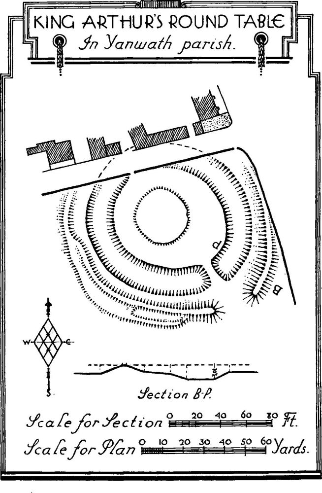
King Arthur's Round Table, in Yanwath Parish.
a(12). King Arthur's Round Table (Plate 159), earthwork at the road-junction 400 yards S.S.E. of Eamont Bridge, occupies an almost level site and is partly cut into by the roadway on the N. and E. sides. The work consists of a roughly circular area 150–160 ft. in diameter, enclosed by a ditch, beyond which is a berm and an outer rampart. The outer scarp of the rampart has been widened on the S.W. and there are traces of what might appear to be a portion of small further rampart. One Busby, however, owner of the adjoining Crown Inn, is said to have "deepened the ditch and then thrown the earth upon the banks late in the 18th century." It seems doubtful if he did very much deepening but his efforts are probably responsible in part for the fact that in places the rampart encroaches on the berm and probably he or some similar despoiler was responsible for the variation to the outer scarp of the S.W. portion of the rampart. There is an entrance with a causeway across the ditch on the S.E. and there was formerly an entrance on the N.W. where is now the modern gateway in the field-wall; this entrance together with the ditch and rampart has been destroyed in making or widening the road. The making of the road on the N.E. has also destroyed and defaced most of the rampart on that side. Within the enclosure, though not quite central, is a slight circular platform. It has been suggested that this is a later addition for a cockpit or some such purpose. There is, however, no real evidence to suggest its being of later date.
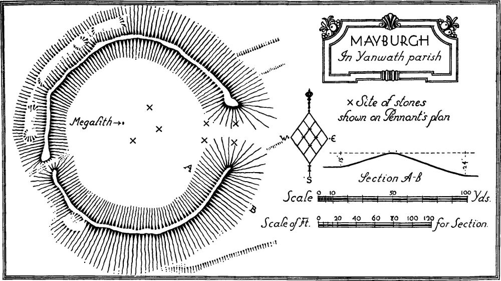
Mayburgh, in Yanwath parish
Stukeley records that the Scots Army that accompanied Charles II to Worcester camped for some time on this site (Stukeley, Itinerarium Curiosum II).
Condition—Fairly good.
a(13). Ring Work about 200 yards S. of (12) has been practically entirely obliterated by the construction of the entrance and lodge to Lowther Park. Its form is shown on Stukeley's drawing (Itinerarium Curiosum II Pl. 84) and Pennant's plan (Tour in Scotland I, Pl. XXXVII).
a(14). Mayburgh (Plate 1), earthwork ¼ m. S.W. of Eamont Bridge, occupies a slight knoll. It consists of a rampart varying from 8 ft. to a little over 15 ft. in height from the level within, and enclosing a flat circular area of about 1½ acres. There is an entrance on the E. side and a modern gap on the S.W. The rampart is composed of a piled heap of comparatively small stones. There has been some destruction of the outer scarp caused by the carting away of stones for road metal, etc. The rampart is now largely covered with turf. Within the enclosure is a standing stone (Plate 2) the greatest girth of which is 18 ft. and standing 9 ft. above the level of the soil. It is known, from more than one source (e.g. Pennant's Tour in Scotland, Pl. XXXVII), that in the 18th century there were eight of these stones, three grouped with the existing one and four grouped to flank the entrance.
Condition—Fairly good, but planted with trees.
b(15). Castlesteads, settlement and enclosure in Yanwath Wood, over 2 m. S. of Eamont Bridge, occupies a slight knoll. The work consists of a roughly circular enclosure of about ¼ acre, defended, on its western half, by three ramparts with two medial ditches. There is a suggestion of the rough line of the innermost rampart on the eastern half but the outer ramparts have entirely disappeared probably owing to the formation of paths. There seems, however, no very definite evidence that they existed on this half. Within the enclosure are traces of cross walls and sinkings and some 30 yards S.W. of the enclosure is a roughly circular sinking with traces of a bank on its E. side; there is nothing to indicate whether this latter is of any great age.
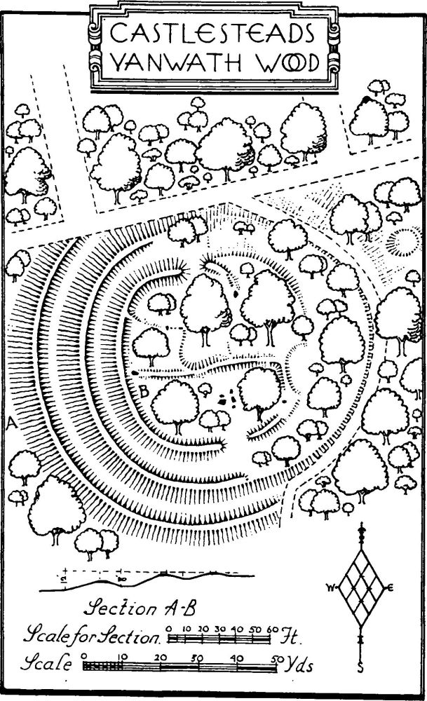
Castlesteads, Yanwath Wood
The work is of unusual type. The inner enclosure suggests a settlement with its cross walls and irregular shaped sub-division, but the number and strength of the ramparts are not normal in such a work.
Condition—Poor, planted with trees.
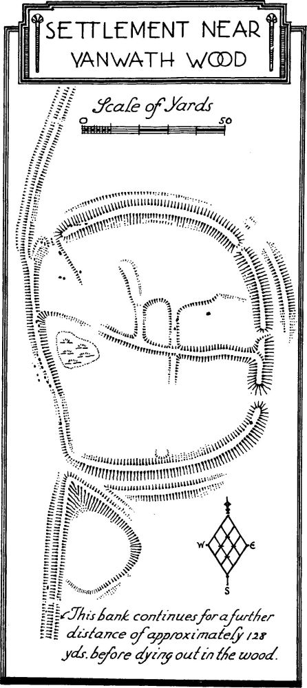
Settlement near Yanwath Wood
b(16). Village Settlement, N. of Yanwath wood and 1¾ m. S. of Eamont Bridge, occupies the S. end of a slight spur. The work consists of a roughly oval enclosure of just over 1 acre, enclosed by a slight rampart showing the line of a former wall. In addition there still remain traces of an outer ditch with an outer rampart. There are no traces of a ditch along the W. side but, as the whole field without the enclosure has since been under the plough, it may have been destroyed, even as parts of ditch and rampart have been on the other sides. The entrance was at the N.W. corner and had a wall running roughly inwards at right angles from the E. side of the opening. There are several gaps in the rampart on the E. side but these would appear to be modern except perhaps for that at the S.E. angle. Internally there are traces of the usual walls forming enclosures, but they are very indefinite and there are no signs of circular huts. The W. rampart retains a number of orthostats.
Extending N. from the rampart, W. of the N.W. entrance, a rampart or dyke with ditch on its W. side runs for some 60 yards. A similar dyke runs from the S.W. angle in a S.S.W. direction until it reaches the S. boundary of the field some 135 yards away and beyond for some 50 yards into Yanwath wood. In the angle between this dyke and the outer ditch of the enclosure there is a roughly triangular sinking.
Condition—Bad.
b(17). Mound, about 210 yards W.S.W. of the settlement, is about 66 ft. in diameter and 5 ft. high. It has a sinking in the top.