An Inventory of the Historical Monuments in the County of Northamptonshire, Volume 4, Archaeological Sites in South-West Northamptonshire. Originally published by Her Majesty's Stationery Office, London, 1982.
This free content was digitised by double rekeying. All rights reserved.
'Sulgrave', in An Inventory of the Historical Monuments in the County of Northamptonshire, Volume 4, Archaeological Sites in South-West Northamptonshire(London, 1982), British History Online https://prod.british-history.ac.uk/rchme/northants/vol4/pp138-141 [accessed 26 April 2025].
'Sulgrave', in An Inventory of the Historical Monuments in the County of Northamptonshire, Volume 4, Archaeological Sites in South-West Northamptonshire(London, 1982), British History Online, accessed April 26, 2025, https://prod.british-history.ac.uk/rchme/northants/vol4/pp138-141.
"Sulgrave". An Inventory of the Historical Monuments in the County of Northamptonshire, Volume 4, Archaeological Sites in South-West Northamptonshire. (London, 1982), British History Online. Web. 26 April 2025. https://prod.british-history.ac.uk/rchme/northants/vol4/pp138-141.
In this section
56 SULGRAVE
(OS 1:10000 a SP 54 NE, b SP 54 SE, c SP 54 NW, d SP 54 SW)
The rectangular parish covers 815 hectares and lies across the headwaters of the E.-flowing R. Tove. The lower ground to the N. and S. of the central stream is on Upper Lias Clay but there are outcrops of limestone particularly in the S.W. around the village and Boulder Clay caps the highest part in the S. at about 170 m. above OD. The major monument in the parish is the medieval ringwork (3) which has recently been excavated.
Prehistoric and Roman
A few worked flints are recorded (SP 574474; CBA Group 9, Newsletter, 8 (1978), 22). A scatter of abraded Roman sherds was found during the excavation of the medieval ringwork (3) (Arch. J., 134 (1977), 109).
a(1) Flint-Working Site and Roman Settlement (SP 561472), in the extreme N. of the parish, on Northampton Sand at 175 m. above OD. Worked flints of Neolithic type and sherds of Roman pottery have been discovered (Banbury Museum; Oxoniensia, 36 (1971), 112).
ab(2) Roman Settlement (SP 579450), in the S.E. of the parish, on limestone at 147 m. above OD. A scatter of Roman sherds has been noted (Northants. Archaeol., 13 (1978), 182).
Medieval and Later
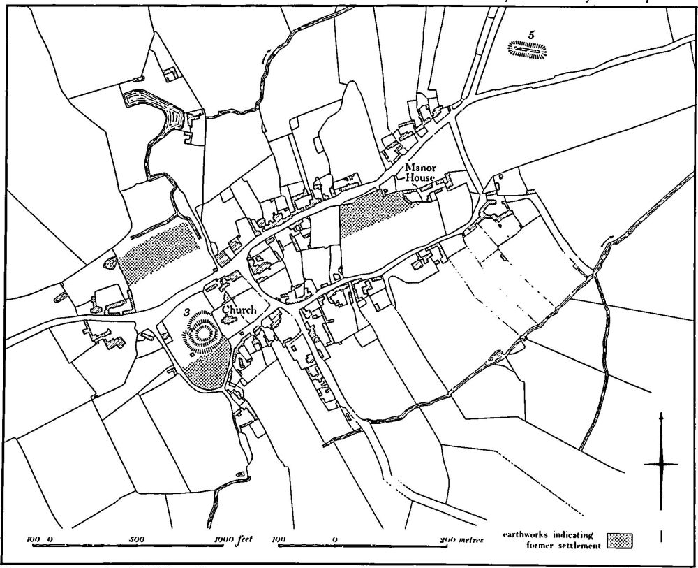
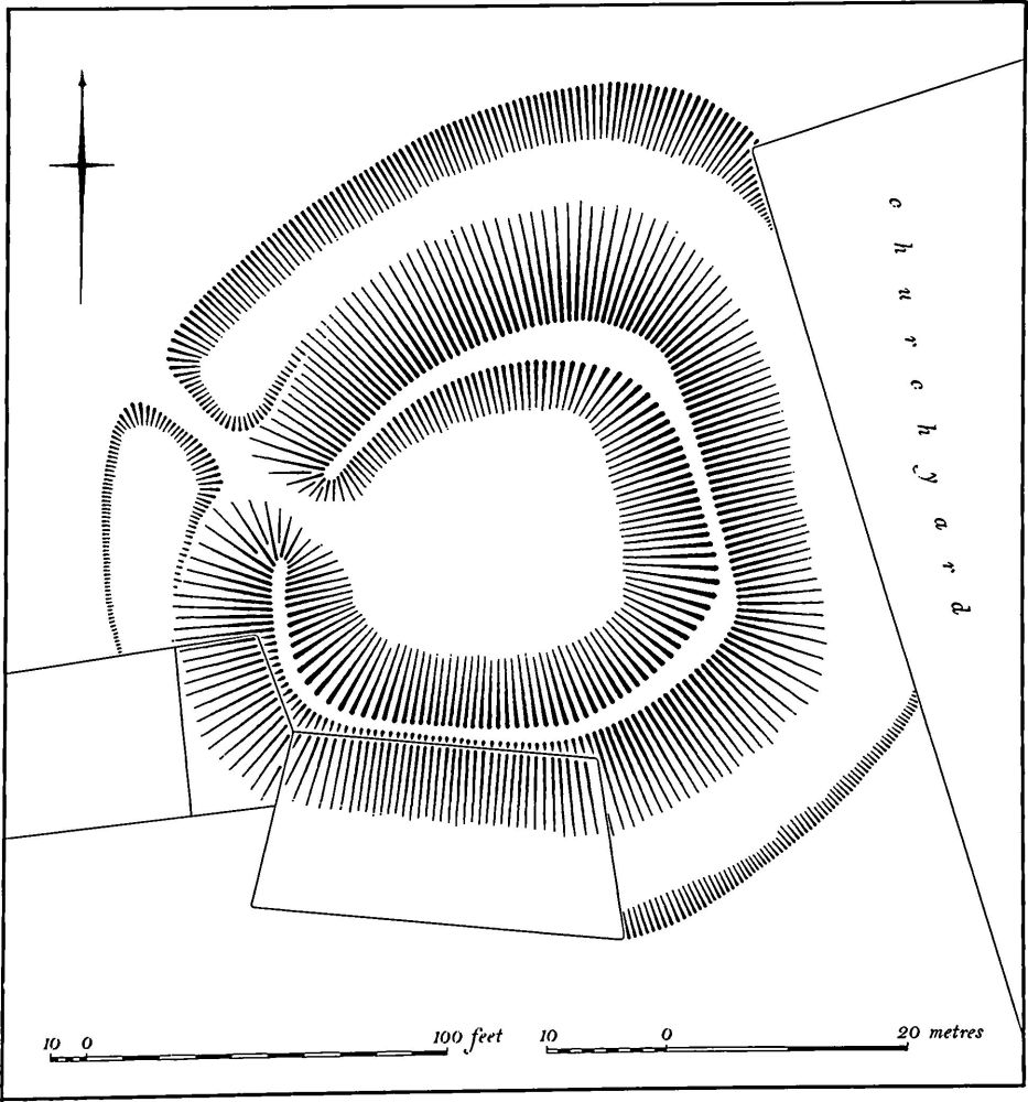
a(3) Ringwork (SP 557453); Figs. 107 and 108; Plate 5), known as Castle Hill, lies at the S.W. end of the village, immediately S.W. of the church, on limestone of the Upper Estuarine Series at 155 m. above OD. The earthworks now consist of a roughly circular bank, though there are indications that this is actually made up of five approximately straight sides. The bank survives up to 3.6 m. high, with a flat top, and there are traces of a surrounding ditch 0.3 m. deep. A causeway across the ditch on the N.W. side leads through the bank and provides the only entrance.
Nothing is known of the history of the site beyond the fact that Domesday Book records that the manor of Sulgrave was held by Ghilo in 1086 and that three undertenants, Hugh, Landric and Otbert, held it of him (VCH Northants., I (1902), 345). A ringwork at Culworth (1) was probably also held by Landric of Ghilo, and a ringwork or motte at Weston and Weedon (5) was held directly by Ghilo.
The site was excavated between 1960 and 1976 and during this period different interpretations of the evidence have been put forward. The most recent of these theories is presented here (Arch. J., 134 (1977), 105–14).

Fig. 107 Sulgrave (3) Ringwork, (4) Settlement remains, (5) Pond
The earliest structure, probably dating from the late 10th century, consisted of a timber building, almost certainly a hall, with a detached stone and timber building, possibly a kitchen. In the early 11th century the hall was altered and repaired and a stone building was erected to the N. Shortly afterwards a bank and ditch were constructed which perhaps surrounded the whole site. In the mid 11th century a massive rampart was added to the earlier bank and the earlier stone building was incorporated into this. This rampart may also have enclosed the adjacent church. At the same time the earlier timber structure was dismantled and replaced by a stone hall. Soon afterwards the stone building in the rampart started to collapse under the pressure and was therefore filled in. A timber tower was then raised on the rampart, using the walls of the stone building as foundations; the rampart itself was heightened and widened and it was perhaps at this stage that the present ringwork was created. In the early 12th century the rampart was heightened again and the tower rebuilt. However, apart from some apparent traces of huts, the interior shows no evidence of use at this period. The whole site was abandoned by the mid 12th century. The entrance in the N.W. corner of the ringwork is a 19th-century modification. (RAF VAP CPE/UK/1926, 1215–6; CPE/UK/1994, 1028–30, 1097–8; Med. Arch., 6–7 (1962–3), 333; 17 (1973), 147; BNFAS, 2 (1967), 28; 3 (1969), 27–9; Northants. Archaeol., 8 (1973), 19; Arch. J., 125 (1968), 305; 126 (1969), 131; Current Arch., 12 (1969), 19–20; Chateau-Gaillard, 2 (1967), 39–48; CBA Group 9, Newsletter, 3 (1973), 20)
a(4) Settlement Remains (SP 555454, 556452 and 559455; Fig. 107), formerly part of Sulgrave, lie in three places in the village, on limestone of the Upper Estuarine Series between 144 m. and 152 m. above OD. Although the remains are visually unimpressive they are potentially important since work on them may help to elucidate both the growth of the village and its relationship to the ringwork (3).

Fig. 108 Sulgrave (3) Ringwork
The surviving documents do not indicate any marked fall in the population of Sulgrave. The village is first mentioned in 1086, in Domesday Book, as a single manor with a recorded population of 27 (VCH Northants., I (1902), 345). In 1301, 42 people paid the Lay Subsidy (PRO, E179/ 155/31) and the village paid 60s. 2½d. for the Lay Subsidy of 1334 (PRO, E179/155/3). In 1377, 101 people over the age of 14 paid the Poll Tax (PRO, E179/155/28) and 42 people are recorded in the Lay Subsidy of 1525 (PRO, E179/155/159). In 1673, 78 people paid the Hearth Tax (PRO, E179/254/14). There were 414 people living in the parish by 1801.
The plan of the village today is a rough figure-of-eight, with the church and ringwork in the centre of the S.W. loop and the manor house at the N.E. end of the N.E. loop. In the absence of any map earlier than the 19th century it is difficult to interpret this layout. One possible explanation is that the original village lay around the church and ringwork and later expanded N.E. along the two parallel streets by gradual growth or planned development. However, the existence of earthworks on the northernmost of these two streets, together with the fact that the N.E. end of the loop did not exist as a throughroad in the early 19th century (1st ed. 1 in. OS map, 1834), suggests that the village was once a single street and that the S.E. parts of the loops were originally a back lane which has become partly built up.
The remains fall into three groups. On the N.W. side of the village, behind the existing modern houses (SP 555454), are the remains of abandoned closes bounded by low banks and shallow ditches, which are presumably the former gardens of houses which once lined the street. Further S., immediately S. of the ringwork (SP 556452), on the inside of the bend of the S.W. loop, there is an area of uneven ground which contains fragments of stone walling now grassed over. These may be the sites of houses but their proximity to the ringwork suggests that they are perhaps part of a later manorial complex.
To the N.E., on the S. side of the northern street and immediately S.W. of the present manor house (SP 559455), are the fragmentary remains of sunken platforms and low scarps and banks bounded on the S. by a continuous scarp up to 1 m. high. These appear to be the sites of houses which lay along the street. (RAF VAP CPE/UK/1926, 1216–8; CPE/UK/1994, 1028–30, 1097–9)
b(5) Pond (SP 562458), lay immediately N.E. of the village, on Upper Lias Clay at 140 m. above OD. It is shown on modern OS maps as a rectangular pond orientated E.-W., 60 m. by 25 m. but has now been destroyed by ploughing. It appears to have been embanked on all sides, with a second bank on its N. side. (Air photographs in NMR)
b(6) Pillow Mound (SP 56484527; Plate 7) lies in permanent pasture S.E. of the village, on Upper Lias Clay at 145 m. above OD. The mound is rectangular, 12 m. long, 7 m. wide, and less than 0.25 m. high, with a flat top. A narrow ditch only 2 m. wide surrounds it. The mound is orientated E.-W. and lies in the S.E. corner of a furlong of ridge-and-furrow running E.-W. which appears to respect it. (Air photographs in NMR)
(7) Cultivation Remains (Plate 7). The common fields of Sulgrave were enclosed by an Act of Parliament of 1767, but no map is known to survive. Ridge-and-furrow of these fields exists on the ground or can be traced on air photographs over much of the parish, arranged in end-on and interlocked furlongs. It is particularly well preserved to the S.E. of the village where considerable areas are still under grass and a number of interesting features are visible. For example, in an area of ill-drained ground at SP 563451 a block of slight, worn-down ridge-and-furrow only 50 m. long is surrounded by well-preserved ridge-and-furrow (Plate 7). This may represent different stages of abandonment of former arable land. A circular area to the E., 30 m. in diam., where the ridge-and-furrow has been partly flattened, may be the remains of a rick stand (see RCHM Northants. III, Brixworth (42) and p. liii). RAF VAP CPE/UK/ 1926, 1214–9; CPE/UK/1994, 1027–31, 1095–1100, 3096–8)
Undated
b(Mound (SP 55934716), possibly a round barrow, lies in the extreme N. of the parish, on the summit of a rounded hill of Northampton Sand known as Barrow Hill, at 180 m. above OD. The mound is 22 m. in diam. and 2 m. high, and is rather conical. It has been damaged by ploughing round its base and no trace of a surrounding ditch can be seen, except on the N. side. It may be the site of a medieval windmill. (RAF VAP CPE/UK/1994, 1098–99; 3097–8)