An Inventory of the Historical Monuments in the County of Northamptonshire, Volume 3, Archaeological Sites in North-West Northamptonshire. Originally published by Her Majesty's Stationery Office, London, 1981.
This free content was digitised by double rekeying. All rights reserved.
'Cold Ashby', in An Inventory of the Historical Monuments in the County of Northamptonshire, Volume 3, Archaeological Sites in North-West Northamptonshire(London, 1981), British History Online https://prod.british-history.ac.uk/rchme/northants/vol3/pp51-53 [accessed 19 April 2025].
'Cold Ashby', in An Inventory of the Historical Monuments in the County of Northamptonshire, Volume 3, Archaeological Sites in North-West Northamptonshire(London, 1981), British History Online, accessed April 19, 2025, https://prod.british-history.ac.uk/rchme/northants/vol3/pp51-53.
"Cold Ashby". An Inventory of the Historical Monuments in the County of Northamptonshire, Volume 3, Archaeological Sites in North-West Northamptonshire. (London, 1981), British History Online. Web. 19 April 2025. https://prod.british-history.ac.uk/rchme/northants/vol3/pp51-53.
In this section
19 COLD ASHBY
(OS 1: 10000 a SP 67 NW, b SP 67 NE, c SP 67 SW, d SP 67 SE)
The parish occupies a diamond-shaped area about 865 hectares in extent, on a watershed with radiating streams flowing generally N. towards the R. Avon and S. towards the R. Nene. The highest ground, W. of the village, rises to 206 m. above OD and is part of a large outcrop of Northampton Sand which makes up the central part of the parish. Upper Lias Clay is exposed by the down-cutting of the streams, and along the N.E. edge and in the S. are expanses of Boulder Clay. The only monument of interest in the parish is the group of earthworks (2) immediately N. of the village. These are bounded on the N. by an unusually wide hollow-way and may be either the remains of an abandoned part of the village or the site of a monastic grange of Sulby Abbey which is known to have existed in the parish.
Prehistoric
b(1) Ring ditch and enclosure (SP 65867803), S.W. of Portly Ford Bridge, in the N. of the parish, on gravel at 152 m. above OD. Air photographs (in NMR) show three sides of a small trapezoidal enclosure only 20 m. by 25 m., with a ring ditch 8 m. in diam. within it.
Medieval and Later

Fig. 45 Clipston (7) Settlement remains
b(2) Hollow-way and site of monastic grange (SP 656765; Fig. 46), lie in a large pasture field immediately N. of Main Street, on the N. side of the village, on Northampton Sand at 195 m. above OD. The main feature is a broad hollow-way, 10 m. wide and 0.5 m. deep. It runs from the existing track which leads S. to the village (at SP 65537660), and curves around the marshy source of a N.-flowing brook to meet the road from Naseby (at SP 65757654). Here a N. branch continues as the modern road but the main hollow-way also continues in a mutilated form further E. across the next field until it is lost in the modern arable land. On the N. side of the hollow-way, near its junction with Naseby Road, a small subsidiary hollow-way only 5 m. across runs N.E. for a few metres before it reaches arable land. In the area to the S. of the hollow-way, between it and the present village, are five large rectangular closes bounded by low scarps and banks only 0.25 m. high. At the S. ends, and extending as far as the back gardens of the modern council houses which line Main Street, there is a group of small rectangular paddocks edged by low stone walls within which are several building platforms. Throughout much of the medieval period the main manor of Cold Ashby was held by Pipewell Abbey and the monastic farm was apparently of considerable size and importance. Bridges, writing in the early 18th century (Hist. of Northants., I (1791), 550–1), said that at that time the building still stood 'in the fields'. The earthworks probably represent the site of this grange; the field is still known as Grange Field (RAF VAP CPE/UK/1994, 4175–6).

Fig. 46 Cold Ashby (2) Hollow-way and site of monastic grange

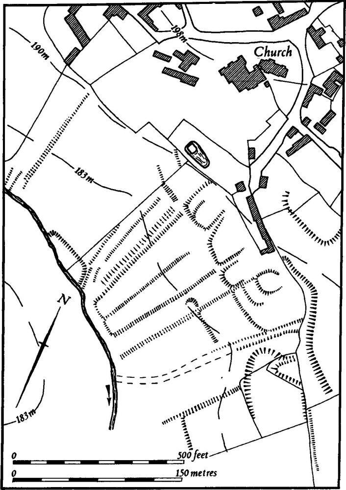
Fig. 47 Cold Ashby (3) Settlement remains
b(3) Settlement remains (SP 656760; Fig. 47), formerly part of Cold Ashby, lie on the S. side of the village, S.E. of the church, on Northampton Sand, at 180 m. above OD. A group of long closes, bounded by low banks and shallow ditches, extend down the hillside towards a small stream. At their upper, N. ends are rectangular raised platforms, presumably the sites of former houses which lay along an old road running S.E. from the village and roughly parallel to the present Thornby Road to the N.E. Further N.W., in the angle between Church Lane and West Haddon Road (SP 653763), are further earthworks of houses and closes (not shown on plan). These remains indicate either that the village plan has been altered in the past or that there has been a fall in population at some time. In view of the evidence of surviving records the former suggestion is more likely. In 1086 Domesday Book gives a recorded population of 14 (VCH Northants., I (1906), 320, 325, 339, 347). In 1377, 82 people over the age of 14 paid the Poll Tax (PRO, E179/155/28) and in 1673, 39 people paid Hearth Tax (PRO, E179/254/14).
(4) Cultivation remains. The date of the enclosure of the common fields of Cold Ashby is not known. Ridge-and-furrow of these fields survives on the ground or can be traced on air photographs to the N. and N.E. of the village, mainly in end-on furlongs, although in the N. some furlongs were arranged obliquely to one another in response to the direction of the slope (RAF VAP CPE/UK/1994, 4465; 106G/UK/636, 4276–9, 3177–8).