An Inventory of the Historical Monuments in the County of Northamptonshire, Volume 3, Archaeological Sites in North-West Northamptonshire. Originally published by Her Majesty's Stationery Office, London, 1981.
This free content was digitised by double rekeying. All rights reserved.
'Canons Ashby', in An Inventory of the Historical Monuments in the County of Northamptonshire, Volume 3, Archaeological Sites in North-West Northamptonshire(London, 1981), British History Online https://prod.british-history.ac.uk/rchme/northants/vol3/pp34-37 [accessed 19 April 2025].
'Canons Ashby', in An Inventory of the Historical Monuments in the County of Northamptonshire, Volume 3, Archaeological Sites in North-West Northamptonshire(London, 1981), British History Online, accessed April 19, 2025, https://prod.british-history.ac.uk/rchme/northants/vol3/pp34-37.
"Canons Ashby". An Inventory of the Historical Monuments in the County of Northamptonshire, Volume 3, Archaeological Sites in North-West Northamptonshire. (London, 1981), British History Online. Web. 19 April 2025. https://prod.british-history.ac.uk/rchme/northants/vol3/pp34-37.
In this section
14 CANONS ASHBY
(OS 1: 10000 a SP 55 SE, b SP 54 NE)
The parish occupies some 750 hectares and is bounded on the E. and S. sides by a small tributary which runs W. to the R. Cherwell. It is on land sloping gently S. between 180 m. and 130 m. above OD, and is covered by Boulder Clay, except round the church and the site of the former village which stand on a narrow outcrop of Northampton Sand, and in the N.W. of the parish where the down-cutting of another stream has exposed the underlying Upper Lias Clay. The village of Canons Ashby (1), now almost deserted, is of considerable interest, both because it appears to have been a large and prosperous place until its apparently deliberate abandonment and because its earlier expansion seems to have been achieved at the expense of former arable land. Of the monastic foundation that gives its name to the village little survives apart from the church; the earthworks close by, although usually interpreted as of monastic origin, are probably in part post-medieval gardens (2).
Prehistoric
In 1873 a jade axe was exhibited at the Society of Antiquaries. It was said 'to have been found in a British station, near Ashby about thirty-five or forty years ago', but in fact came from King's Sutton parish (PPS, 29 (1963), 163).
A late Bronze Age spearhead, also said to have been found in the parish in the 19th century, was exhibited at the same time. Part of the ashwood shaft still remained in the socket (PSA, 5 (1873), 442; OS Record Cards).
Medieval and Later
a(1) Deserted village of Canons Ashby (SP 576507; Fig. 34; Plate 20), lies immediately N. of Canons Ashby House, on Northampton Sand at 157 m. above OD. The village was first mentioned in Domesday Book (VCH Northants., I (1902), 341, 372) with a recorded population of 16. In about 1150 the Augustinian priory (2) was founded; it apparently lay at the S. end of the village, but it later acquired most of the parish. In 1301, 18 taxpayers paid the Lay Subsidy (PRO, E179/155/31) and the village is mentioned in the 1316 Nomina Villarum. There were 41 houses in 1343 (M. W. Beresford, The Lost Villages of England (1954), 366); in 1377 82 people over the age of 14 paid the Poll Tax (PRO, E179/155/27–9). However, in 1489 the prior of Canons Ashby enclosed 100 acres of land, converting it to pasture and destroying three houses at the same time, and in 1492 he evicted 24 people. By 1524 only 21 taxpayers were listed (PRO, E179/155/122–64) and by 1535 only nine tenants paid rent to the priory. On the dissolution of the priory in 1537 the manor passed to Sir Francis Bryan and a year later to Sir John Cope who, by 1547, had 2000 sheep in the parish. The Hearth Tax Returns of 1674 list five people paying tax (PRO, E179/254/14) and Bridges, writing around 1720, said that there were three farm-houses and two or three lodges in the village (Hist. of Northants., I (1791), 223); he also recorded the tradition that the village 'was formerly very considerable'. By 1801 the population of the parish was 40 (K. J. Allison et. al., The Deserted Villages of Northants. (1966), 35).
The surviving earthworks are in good condition. They not only confirm the evidence of the 1377 Poll Tax Returns, indicating that the village was then a large one, but also suggest that the increase in size between 1301 and 1377 may have resulted in the expansion of the village northwards across former arable land.
The original main street appears to have been approximately on the line of the present road which runs N.W. past Canons Ashby House. Traces of a hollow-way still remains on the E. side of this road, and then W. of the road, running N.W. across the park towards the mound (3). There are no indications of former buildings to the W of the hollow-way, but the area may have been levelled for landscaping. To the E. of the hollow-way there is a series of embanked paddocks or closes, some with possible building platforms at their W. ends; the E. ends of the closes terminate against a shallow hollow-way or back lane running N.W.–S.E. To the S.E., along the Adstone road, other closes remain.
At the N. end of the site, and separated from the rest by a later quarry pit probably dug through a hollow-way, are more closes with house-sites at their W. ends. Here, however, between the W. ends of the closes and the back lane to the E., are three blocks of very short and degraded ridge-and-furrow. The southernmost ridges are too short ever to have been ploughed after the closes were created and the W. ends are all cut through by the close boundaries. This indicates that the ridge-and-furrow originally extended further W. and that the closes and house-sites have been laid out on it. A few sherds of medieval pottery, all of 13th or 14th-century date, have been found on the site, mainly in the areas formerly occupied by buildings.
In addition to the hollow-ways in and around the deserted village various others survive or are visible on air photographs. For example S.W. of the gardens of Canons Ashby House and parallel to the existing road to Eydon (SP 574504) a broad hollow-way extends down the hillside towards the fishponds (4). Another, at the extreme N. of the site, appears to run on E. of the present road and then meet it. From such evidence it is possible to make a tentative reconstruction of the late medieval road system of the area (RAF VAP CPE/UK/1994, 4096–7; CUAP, BEN25).
a(2) Site of Augustinian priory and of 16th-century house and (?) gardens (SP 577505; Fig. 34; Plate 23), lies around the parish church which still retains a large part of the fabric of the original priory church.
The priory, dedicated to the Blessed Virgin, was founded in 1147–51, probably for 13 canons, and was dissolved in 1536. A church, land, houses, crofts, a fishpond and a horse-mill were among the gifts at its foundation (D. M. Knowles and R. N. Hadcock, Medieval Religious Houses (1957), 132; VCH Northants., II (1906), 130). After the Dissolution Sir John Cope acquired the site and built a house, apparently to the S. of the church and partly out of the monastic buildings. This was superseded by the present house after the estate had passed to Cope's brother-in-law, John Dryden, in 1551.
The church now consists of two bays of the nave and part of the north aisle of the priory church; excavations carried out in 1828 by Sir Henry Dryden to the E. and S. of the present building revealed parts of the rest of the nave and north aisle as well as of the chancel. There was no south aisle; the cloister was directly attached to the S. side of the nave and was surrounded by the usual conventual buildings, including a large chapter house (G. Baker, Hist. of Northants., II (1836–41), 7–15; copies of conjectural plans in NMR).
In 1970 excavations were carried out in the S.W. corner of the cloister on behalf of the DOE. As this was done in order to ascertain possible damage to the medieval layers by proposed buildings it was mainly restricted to the upper levels and little of medieval date was recorded. Only the S.W. corner of the cloister was revealed, above which was a late 16th-century floor. The excavator concluded that the medieval building was the vaulted undercroft of the monastic refectory which had been incorporated into a 16th-century building on the site. The latter was demolished in the 18th century. It is probable that this structure was part of the house built by Sir John Cope in the mid 16th century. Large quantities of medieval floor tiles (NM; Plate 23) were recovered as well as fragments of a late 16th or early 17th-century Venetian glass goblet (BNFAS, 4 (1970), 16; Med. Arch., 14 (1970), 169; Northants. Archaeol., 9 (1974), 57–67).
The surviving earthworks fall into three groups. Immediately E. of the church, within the graveyard, are several low scarps up to 1 m. high which may be, in part, the foundations of the medieval church.
To the S.E. is a large trapezoidal area occupying most of a shallow valley and formerly bounded, except on the N.W. side, by a broad flat-topped bank or terrace 1 m.–1.5 m. high with a slight inner ditch. The S. and S.W. sides have recently been destroyed and little trace remains. Within this enclosure, along its E. side, were three irregular ponds, now reduced to one large marshy area in the valley bottom (The plan shows these features and the destroyed bank as on the OS 25 inch map, Northants. LV.2, 1900 ed.). In the N.W. corner of this area and projecting into it there was formerly an L-shaped pond, with a large outer bank which retained the water. This is usually described as a moat. It, too, has recently been altered and partly filled in. In the centre of the area and immediately N. of the northernmost pond is a circular mound only 0.5 m. high.
This embanked area and the 'moat' have previously been ascribed to the priory and are traditionally called 'The Canons Walk' or 'The Vineyard'. However there is no direct evidence for this assumption and indeed one feature may indicate the earthworks are of a different period. Air photographs show that before the recent destruction the bank along the S.W. side of the area overlay ridge-and-furrow (CUAP, BEN25; RAF VAP CPE/UK/1994, 4096–7). Unless this ridge-and-furrow is of a very early date the overlying bank or terrace-walk is of the late or post-medieval period. Therefore these earthworks are the remains either of part of the monastic gardens or of a mid 16th-century garden to the S. and S.E. of Sir John Cope's house. The form of the earthworks would agree with either hypothesis, though the latter is more likely.
In the two modern paddocks N. and W. of the church are other earthworks. Most are indeterminate scarps and hollows of unknown purpose and date, but a long rectangular depression N.E. of the church may be a former fishpond. In the same area is the 'Monks Well' which consists of an 18th or 19th-century stone structure above a spring; in the 19th century numerous lengths of lead and wooden pipe were discovered which may have been part of the monastic water supply.
a(3) Mound (SP 57505091; Fig. 34; Plate 21), lies N.W. of Canons Ashby House on clay at 158 m. above OD. It has previously been described as a barrow (1st ed. 1 in. OS map (1834)) or as a motte (Pevsner, Northamptonshire (1961), 135). From its present form it is more likely to have been part of post-medieval landscaping of the park, particularly as it is in line with the N.W. elevation of Canons Ashby House. However even by the early 18th century its original purpose was forgotten for Bridges (Hist. of Northants., I (1791), 223) described it as 'anciently a fortification', and said that 'Cannon-balls have frequently been dug up there and the place still retains the name of Castle-hill'. It is possible that there was an earlier mound here, which was later landscaped to its present form.
The mound is polygonal, with several straight lengths around its circumference. It is up to 3 m. high, with an uneven summit and an inner bank on the N.E. side. Traces of a shallow ditch surround it except on the E. To the S. and N. are broad hollow-ways leading into the former village (1) (CUAP, BEN25).
a(4) Fishponds (centred SP 569507), in the valley of the small stream to the W. of the village, on clay and alluvium at about 150 m. above OD. There are four ponds each covering some 3 hectares, and each formed by the construction of a simple dam across the valley. The dams are earthen, up to 2 m. high, with the exception of the southernmost one, close to the Eydon road (at SP 57405034), which is a large structure with a dressed stone rear revetment probably of 18th or 19th-century date.
A small wood 200 m. in length separates the ponds into two pairs; there are no indications that there was ever a fifth, linking pond occupying this area. The two lower, southernmost ponds are still water-filled but the other pair are now marshy depressions within a plantation. It is not clear whether the two pairs of ponds are contemporary. As they now appear they may all have been ornamental, part of a landscaped park around Canons Ashby House. Alternatively they could all have originated as medieval fishponds two of which have been modified and maintained as landscape features. The lowest pond certainly appears to have existed and to have extended to more than its present area during the period when the field to the E. was being ploughed in ridge-and-furrow; the ridges end several metres from the pond, except at one point where treading by cattle has destroyed the edge of the pond and cut into the ridges. This suggests that this pond at least was in existence by the 16th century (see (7)). However, in the early 19th century it is depicted as having a different shape (1st ed. 1 in. OS Map (1834)). It was then more rectangular with a small projection at its S.E. corner, giving a formal appearance reminiscent of a 17th-century ornamental lake. At the same time a building below this lake was termed a mill.
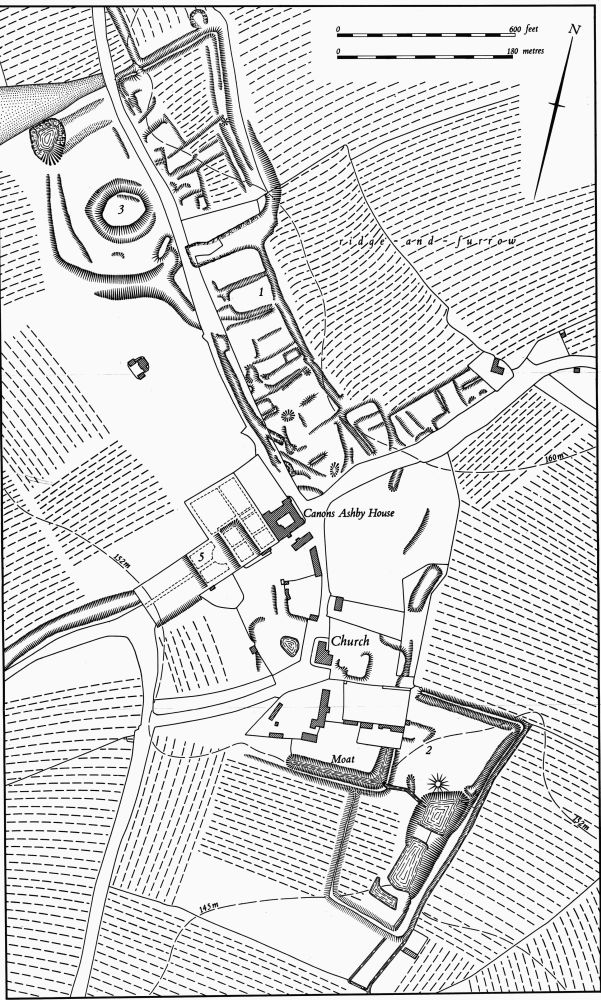
Fig. 34 Canons Ashby (1) Deserted village, (2) Site of priory and of house and gardens, (3) Mound, (5) Garden remains, (7) Cultivation remains
a(5) Garden Remains (SP 576506; Fig. 34), lie immediately S.W. of Canons Ashby House, on Upper Lias Clay, between 150 m. and 155 m. above OD. These gardens were laid out between 1708 and 1710, in what was for that period a relatively old-fashioned design, by Edward Dryden who also altered the house. It is now partly overgrown and abandoned but the main outlines can be recovered. The main part was a long rectangular area extending down the slope from the S.W. side of the house, bounded by high walls. It was divided into four compartments, separated by low scarps all 1 m.–2 m. high, with a long axial path down the centre. The upper two compartments were originally gravelled parterres and the lower two were used for vegetables and fruit. To the N.E. of the upper two compartments there is now a large level area, also bounded by walls, which was formerly divided into two unequal parts, one probably a bowling green, the other with two small ponds in it. On the N.W. side of the house is another walled area known as the Green Court. This was originally planted with clipped yew trees. The surviving gate piers are decorated with carved demi-lions holding spheres, the crest of the Drydens, large urns, suits of armour and pinnacles (Country Life, Feb.–March, 1921; C. Hussey, English Gardens and Landscapes, 1700–1750 (1967), 18).
a(6) Windmill mound (SP 56935033), immediately N. of the road to Eydon, on Boulder Clay at 150 m. above OD. The mound is some 20 m. in diam.; there is no indication of a ditch. Although it has been ploughed it still remains about 1 m. high.
(7) Cultivation remains (Fig. 34). The enclosure of the common fields of the parish probably took place between 1539 and 1547 although the exact date is not known. In 1539 it is recorded that the whole of the former arable demesne land of the priory, comprising some 341 acres, lay in the common fields (PRO, E315/399/f126) but by 1547 Sir John Cope was running 2000 sheep on the land of the parish (see(1)).
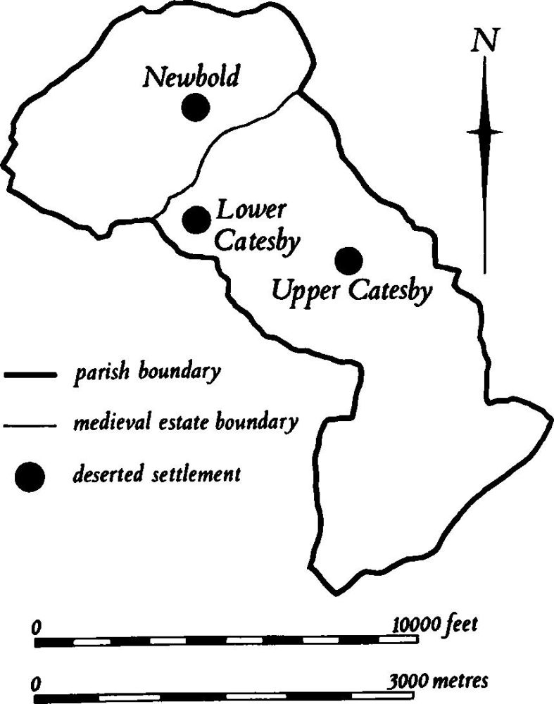
Fig. 35 Catesby Medieval settlements and estates
Ridge-and-furrow of these fields remains on the ground or can be seen on air photographs over most of the parish arranged mainly in interlocked furlongs often of reversed-S form. It is particularly well preserved in Canons Ashby Park (SP 574505) and N. and E. of the deserted village (1) (at SP 575512 and 578507). In the N. part of the former village a block of short ridge-and-furrow has been cut into by later closes, suggesting that the village has expanded over arable land.
In addition a number of former lanes, now reduced to hollow-ways, are visible either on the ground or on air photographs. As a result a large part of the medieval landscape of the parish can be reconstructed (RAF VAP CPE/UK/1994, 4094–9, 2090–5, 4160–4).