An Inventory of the Historical Monuments in the County of Northamptonshire, Volume 3, Archaeological Sites in North-West Northamptonshire. Originally published by Her Majesty's Stationery Office, London, 1981.
This free content was digitised by double rekeying. All rights reserved.
'Thornby', in An Inventory of the Historical Monuments in the County of Northamptonshire, Volume 3, Archaeological Sites in North-West Northamptonshire(London, 1981), British History Online https://prod.british-history.ac.uk/rchme/northants/vol3/pp187-188 [accessed 19 April 2025].
'Thornby', in An Inventory of the Historical Monuments in the County of Northamptonshire, Volume 3, Archaeological Sites in North-West Northamptonshire(London, 1981), British History Online, accessed April 19, 2025, https://prod.british-history.ac.uk/rchme/northants/vol3/pp187-188.
"Thornby". An Inventory of the Historical Monuments in the County of Northamptonshire, Volume 3, Archaeological Sites in North-West Northamptonshire. (London, 1981), British History Online. Web. 19 April 2025. https://prod.british-history.ac.uk/rchme/northants/vol3/pp187-188.
In this section
61 THORNBY
(OS 1: 10000 a SP 67 NE, b SP 67 SE, c SP 67 SW)
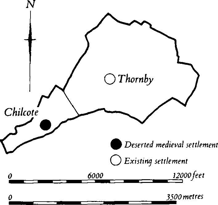
The parish, of about 490 hectares, is compact apart from a narrow area extending S.W. which represents the land of the former village of Chilcote (2). The main part of the parish and the village itself lie on a N.W.–S.E. ridge covered with Boulder Clay and other glacial deposits, with a maximum height of 182 m. above OD. On the steep slopes which fall S.W. from this ridge Northampton Sand and Upper Lias Clay are exposed. Narrow bands of alluvium flank two streams flowing generally S.E., one of which forms the S. boundary of the parish. The site of the deserted village of Chilcote cannot be traced exactly within the lands known to belong to it (Fig. 139) but it has been tentatively located.
Roman
a(1) Roman settlement (?) (SP 674765), N. of Lodge Farm, in the N. of the parish, on sand and gravel at about 160 m. above OD. Roman pottery was discovered during field-walking in 1975 (Northants. Archaeol., 10 (1975), 163).
Medieval and Later
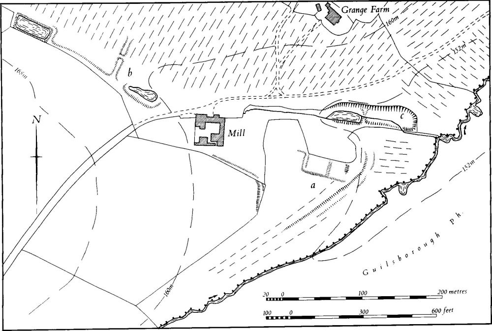
b(2) Deserted settlement of Chilcote, ponds and dam (SP 658747; Figs. 139 and 140), lie in the S.W. of the parish, on Boulder Clay and glacial gravel between 148 m. and 160 m. above OD. Almost nothing is known of their history but it is clear that the long narrow south-western projection of Thornby parish was once the land of Chilcote. The small S.-flowing stream between this land and the rest of the parish still formed a major property boundary as late as 1840 (NRO, Tithe Map). There is nothing on modern maps to indicate that this area was the land of Chilcote and earlier writers have usually assumed that the settlement lay in Cold Ashby parish; indeed a wood in Cold Ashby is called Chilcote's Cover (SP 65257467) on the 1st ed. 1 in. map of 1834. However three large fields to the S., in Thornby parish, just W. of the assumed site of the settlement (centred SP 654745), are called Great and Little Chilcotes on the Thornby Tithe Map.
The name Chilcote, 'the young people's cottages' (PN Northants., 65) suggests that it was a late secondary settlement in the area. The first reference to the place is in Domesday Book where it is described as a manor gelding for only one virgate and with a recorded population of two (VCH Northants., I (1902), 327). Thereafter nothing is known of its size. By the 13th century the manor belonged to Pipewell Abbey (Cal. Chart. R., i, 1226–57, 206–7) with which it remained until the Dissolution. By the early 19th century Grange Farm and a group of cottages existed to the N. of the site and in the early 19th century a large mill and a mill cottage, now abandoned, were built near the medieval settlement.

Fig. 139 Thornby Medieval settlements and estates
Apart from two fragmentary embanked closes and a terrace-way which approaches them from the S.W. ('a' on plan), no surface remains of Chilcote can be traced. N.W. of the present mill a large dam ('b' on plan) 2 m. high, with a later break in its centre, spans the valley, but as it lies on top of earlier ridge-and-furrow it is presumably late or post-medieval in date. It thus has no connection with the settlement at Chilcote and may be a mill dam. Above it is a small embanked pond, but this is the header pond for the 19th-century mill and was linked to it by underground culverts. To the E. of the mill in the valley bottom are two rectangular ponds ('c' on plan), perhaps originally for fish and possibly medieval in date (RAF VAP 541/15, 4388–9).
a(3) Moat (?) (SP 673758), N.E. of Thornby Hall, on Boulder Clay at 150 m. above OD. The site is now only an L-shaped ornamental pond 80 m. by 30 m. and up to 20 m. wide in the corner of the park, and on the Tithe Map of Thornby (NRO, 1840) the pond is shown slightly larger, but still L-shaped. There is no trace of any other side and the identification of the site as a moat is uncertain. The feature may have been associated with a medieval manor house located differently from the adjacent Thornby Hall which has a 17th-century origin.

Fig. 140 Thornby (2) Deserted settlement of Chilcote, ponds and dam
a(4) Windmill mound (SP 66717593), N.W. of the village, on Northampton Sand at 182 m. above OD. The mound is 20 m. in diam. and 1.2 m. high, with a pronounced ramp to the N.E. The field in which it stands was known as Mill Bank on the Tithe Map of 1840 (NRO). It is probably the feature described as a tumulus on the map of Bannaventa and its environs (Archaeologia, 35 (1853), Pl. 16, 394; OS Record Cards).
(5) Cultivation remains. The enclosure of the common fields of the parish took place at an unknown date before 1840 (NRO, Tithe Map). Very little of the ridge-and-furrow survives or can be traced on air photographs, although the few furlongs that do still exist, mainly on the side of the Naseby road, are extremely well preserved. To the S.E. of the village (sp 673753) a large access-way runs parallel to the ridges of one of the rare surviving furlongs.
The common fields assumed to have belonged to the deserted hamlet of Chilcote (2) were also enclosed at an unknown date before 1840. In this area rather more ridge-and-furrow has survived, on each side of the track leading from Thornby to the site of the hamlet. It is in a good state of preservation and is arranged in interlocked furlongs with ridges at right-angles to the slope (RAF VAP CPE/UK/1994, 2460–1; 106G/UK/636, 4177–81).