An Inventory of the Historical Monuments in the County of Northamptonshire, Volume 3, Archaeological Sites in North-West Northamptonshire. Originally published by Her Majesty's Stationery Office, London, 1981.
This free content was digitised by double rekeying. All rights reserved.
'Haselbech', in An Inventory of the Historical Monuments in the County of Northamptonshire, Volume 3, Archaeological Sites in North-West Northamptonshire(London, 1981), British History Online https://prod.british-history.ac.uk/rchme/northants/vol3/pp100-102 [accessed 26 April 2025].
'Haselbech', in An Inventory of the Historical Monuments in the County of Northamptonshire, Volume 3, Archaeological Sites in North-West Northamptonshire(London, 1981), British History Online, accessed April 26, 2025, https://prod.british-history.ac.uk/rchme/northants/vol3/pp100-102.
"Haselbech". An Inventory of the Historical Monuments in the County of Northamptonshire, Volume 3, Archaeological Sites in North-West Northamptonshire. (London, 1981), British History Online. Web. 26 April 2025. https://prod.british-history.ac.uk/rchme/northants/vol3/pp100-102.
In this section
36 HASELBECH
(OS 1: 10000 a SP 77 NW, b SP 67 NE)
The small, roughly rectangular parish, covering only about 690 hectares, lies on a watershed between streams flowing S., ultimately into the Nene valley, and N. to the R. Ise on the N. boundary. The landscape is rolling, with steep-sided valleys. The high ground, rising to 185 m. above OD along the central E.–W. ridge, is covered by Boulder Clay, but elsewhere narrow bands of Oolite Limestone, Northampton Sand, and Upper Lias Clay outcrop on the valley sides.
No prehistoric sites are known and only two possible Roman settlements (1, 2) have been discovered. The main monument in the parish is the extensive earthwork remains of Haselbech village (3). These earthworks result partly from late 16th-century enclosure and partly from landscaping in the 18th century.
Roman
a(1) Roman settlement (?) (sp 723772), in the E. of the parish, on a spur between two S.-flowing streams, on Upper Lias Clay at 130 m. above OD. A small amount of Roman pottery has been found (Northants. Archaeol., 11 (1976), 192; 12 (1977), 212).
a(2) Roman settlement (?) (SP 722765), in the S.E. of the parish, on Boulder Clay, at 165 m. above OD. A small quantity of Roman sherds has been discovered (Northants. Archaeol., 12 (1977), 212).
Medieval and Later
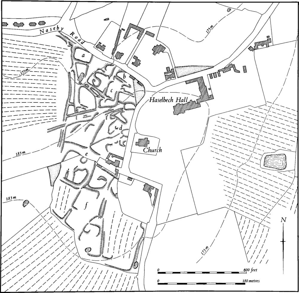
a(3) Settlement remains (centred SP 711774; Figs. 79 and 80), formerly part of Haselbech village, lie to the S.W., W. and N.W. of the now isolated church of St. Michael, on the summit and slopes of a rounded hill, on Boulder Clay and glacial sands and gravels between 172 m. and 184 m. above OD.
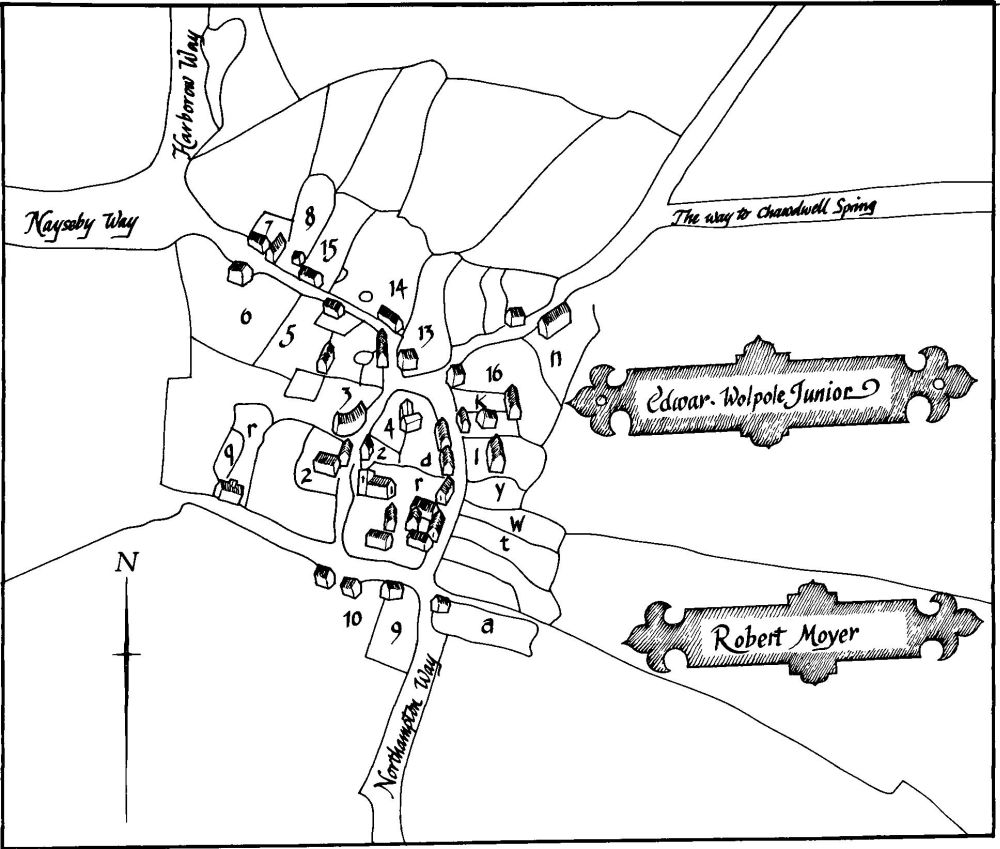
The village of Haselbech was probably always small. No national taxation figures survive to give an accurate estimate of its population in the medieval period after 1086 when, in Domesday Book, it is listed as a single manor with a recorded population of 19 (VCH Northants., II (1906), 323). By the late 16th century much of the parish had come into the hands of the Tresham family and around 1598 the common fields were enclosed and converted to pasture, largely at the behest of Sir Thomas Tresham. A map of that date (NRO; Fig. 80) shows the village with a layout completely different from the present one; in addition to the existing roads there was at that time another street to the E. of the church. A lane also ran W. from the sharp bend S.W. of the church, giving access to the adjacent fields and an isolated farmstead. With the exception of the latter lane, houses lay along all the streets and about 25 separate farmsteads, houses or cottages are depicted. Five empty crofts lay on the E. side of the street, E. of the church, and another two at the N.E. end of the village, on the N. side of the Kelmarsh road. Tresham's enclosure involved the removal of some 700 acres of land which had previously belonged to seven houses in the village. This, and his consequent policy of raising rents, led effectively to the eviction of some 60 people who could not or would not pay. The other landowners in the parish may also have evicted tenants. It is not clear whether the 1598 map depicts the situation before or after this eviction.
Little is known of changes in the village during the 17th century except that Haselbech Hall was built just before 1678 for the Wyke family. This was followed by further alterations in the next century. In 1673 31 householders paid the Hearth Tax (PRO, E179/254/24) and in about 1720 Bridges (Hist. of Northants., II (1791), 35) reported that there were 24 houses in the parish. Sometime before 1773 (Map in NRO) the present park around the hall was laid out. This involved the stopping up of the road E. of the church and the removal of all remaining houses and empty crofts along it. In addition all the houses along the road W. of the church, as well as some along the S. side of the Naseby road, were demolished to provide a clear vista from the hall in an S.W. direction. By 1773 only four buildings stood S. of the church, two to the N. and three along the N. side of the Naseby road. In the 19th century those N. of the church and two to the S. were removed.
On the ground nothing remains of the former street and house-sites E. of the church, as the whole area has been landscaped into shrubberies in the late 19th century. A large area of earthworks to the W. and S.W. of the church mainly relates to the 18th-century landscaping and later changes. However certain features can be explained and identified in relation to the map evidence. For example two of the raised platforms on the S. side of the Naseby road ('a' and 'b' on plan) can be identified as sites of houses on the 1598 map while another ('c' on plan) is the site of a further building also shown on that map. The rather broken scarps running S.S.W. from 'a' and 'b' and the mutilated ditch to the W. of 'c' are thus the close boundaries of these 16th-century houses. The sites of the houses on the W. side of the road, W. of the church, remain only as mutilated scarps and banks ('d' on plan) but the old lane to the S. survives in part as a shallow hollow-way ('e' on plan). Other earthworks to the S. ('f' on plan), which include fragmentary closes, raised platforms and some slight ridge-and-furrow, lie in an area devoid of features on the 1598 map and may indicate an earlier phase of abandonment (RAF VAP 106G/UK/636, 3184–5; CPE/UK/1994, 2457–6; CUAP, BLD 34–7).
(4) Cultivation remains. The common fields of the parish were enclosed by agreement in 1599 (NRO, NRS Transcripts) although the earliest map of the parish (NRO, 1598; Fig. 80) shows it apparently enclosed. This process was carried out at least in part by Sir Thomas Tresham who converted most of the parish to sheep-pasture and it led to riots in the parish in 1607 as part of a general revolt against enclosure in the East Midlands in that year. At that time it was said that only two yardlands out of forty were in tillage (Northants. P. and P., 1 (1949), 29; Trans. Royal Hist. Soc., 18 (1904), 215).

Fig. 79 Haselbech (3) Settlement remains

Fig. 80 Haselbech (3) Plan of village in 1598 (from a map in NRO)
Ridge-and-furrow of the common fields is still preserved on the ground or can be traced on air photographs over almost all of the parish, much of it arranged in rather short interlocked rectangular furlongs which are especially well marked in the N.E. of the parish. In other places, notably on the broken ground to the W. and N.W., the furlongs radiate outwards from the spurs. Ridge-and-furrow is still well preserved in some fields around the village and in the park of Haselbech Hall (RAF VAP CPE/UK/1994, 2454–9, 4459–62; 541/15, 4395–9; 106G/UK/636, 4182–9, 3184–6).