An Inventory of the Historical Monuments in the County of Northamptonshire, Volume 2, Archaeological Sites in Central Northamptonshire. Originally published by Her Majesty's Stationery Office, London, 1979.
This free content was digitised by double rekeying. All rights reserved.
'Hackleton', in An Inventory of the Historical Monuments in the County of Northamptonshire, Volume 2, Archaeological Sites in Central Northamptonshire(London, 1979), British History Online https://prod.british-history.ac.uk/rchme/northants/vol2/pp61-71 [accessed 28 April 2025].
'Hackleton', in An Inventory of the Historical Monuments in the County of Northamptonshire, Volume 2, Archaeological Sites in Central Northamptonshire(London, 1979), British History Online, accessed April 28, 2025, https://prod.british-history.ac.uk/rchme/northants/vol2/pp61-71.
"Hackleton". An Inventory of the Historical Monuments in the County of Northamptonshire, Volume 2, Archaeological Sites in Central Northamptonshire. (London, 1979), British History Online. Web. 28 April 2025. https://prod.british-history.ac.uk/rchme/northants/vol2/pp61-71.
In this section
27 HACKLETON
(OS 1:10000 a SP 75 NE, b SP 75 SE, c SP 85 NW, d SP 85 SW).
The parish covers 2210 hectares, S.E. of Northampton and against the Buckinghamshire boundary which forms its southern limit. It occupies a gently undulating area of land, between 90 m. and 122 m. above OD, completely covered by Boulder Clay except where the down-cutting of the Hackleton Brook and its tributaries has exposed clays, silts and limestones along the valley sides. The modern parish contains the former parishes of Horton, Preston Deanery and Piddington, each with its village in the valley of the Hackleton Brook. The village of Hackleton was formerly a hamlet in Piddington parish. Many prehistoric and Roman settlements have been recorded in the parish, all but one in the Boulder Clay areas. The parish is also notable for its earthworks, which include two deserted medieval villages, Horton (19) and Preston Deanery (17), settlement remains at Piddington (23), and the extensive remains of landscape gardening of Horton Park (20).
Prehistoric and Roman
A looped-and-socketed bronze spearhead (NM) was found near Hackleton before 1910 (Plate 31). A bronze steelyard weight of late Roman date, in the form of a bust, was found at Horton (SP 8254; OS Record Cards; PSA, 15 (1894), 50; lost). Roman pottery has been recorded (SP 78805613, 78945612, 804545; Northants. Archaeol., 10 (1975), 169; NM Records). There are further scatters, mainly of 2nd-century wares at SP 793529 (Northants. Archaeol., 8 (1973), 14).
a(1) Enclosure (SP 78265581), 600 m. W.N.W. of Preston Deanery church, on Boulder Clay at 82 m. above OD, on the N. side of a shallow valley. Air photographs show a rectangular enclosure, 50 m. by 25 m., orientated roughly N.—S., with exactly straight sides and right-angled corners. No entrances or interior features are visible (CUAP, BGC 71).
a(2) Enclosure (?) (SP 786571; Fig. 60), in the extreme N. of the parish, on Upper Lias Clay at 107 m. above OD. Air photographs (in NMR) show what appears to be part of a rectangular enclosure with a well-marked entrance in the centre of the W. side. A linear ditch intersects it.
a(3) Enclosure (?) (SP 79155573; Fig. 60), immediately E. of Preston Deanery village, in the bottom of a small valley, on alluvium at 80 m. above OD. Air photographs (in NMR) show what appears to be a rectangular double-ditched enclosure. However the available photographs are not clear and the feature may be nothing more than a set of intersecting ditches.
b(4) Iron Age Settlement (SP 789526), lies in the S.W. of the parish, on Boulder Clay at 120 m. above OD. A quantity of Iron Age pottery has been found and, a little to the E., a flint arrowhead (Northants. Archaeol., 8 (1973), 4–5).
c(5) Iron Age and Roman Settlement (?) (centred SP 808553), in the N. part of Hackleton village, on Boulder Clay at 91 m. above OD. Finds include: (a) at SP 808553, a Roman coin, a third brass of Valens (NM); (b) at SP 80875511, Iron Age and Roman pottery and tesserae, and a bronze coiled-snake handle (BNFAS, 6 (1971), 13, Hackleton (3); OS Record Cards); (c) at SP 80435510. Roman pottery and bronze coins, probably of Gratian (Northants. Archaeol., 8 (1973), 6; 9 (1974), 89; NM Records); (d) at SP 80525504, Roman coins of Nero, Magnentius and Constantine I (OS Record Cards; NM).
d(6) Iron Age and Roman Settlement (?) (SP 813548), E. of the village of Hackleton, on the Horton Road, on Boulder Clay at 91 m. above OD. A scatter of Iron Age and Roman pottery of the 1st century has been found (Northants. Archaeol., 8 (1973), 6).
d(7) Roman Settlement (?) (SP 800558), N.W. of Hackletonhill, on Boulder Clay at 94 m. above OD. A scatter of Roman pottery, including samian, grey wares and shelly cooking pots, has been found (BNFAS, 7 (1972), 21). NM Records also state that roof tiles and a quern stone have been discovered.
d(8) Roman Settlement (SP 801562), 400 m. N.N.E. of (7) and in a similar situation. Roman pottery, including samian and colour-coated wares, a glass rim, tile and a scatter of stones have been found. Lines of dark soil producing Roman pottery in the same field are perhaps ditches (BNFAS, 6 (1971), 13, Hackleton (2)).
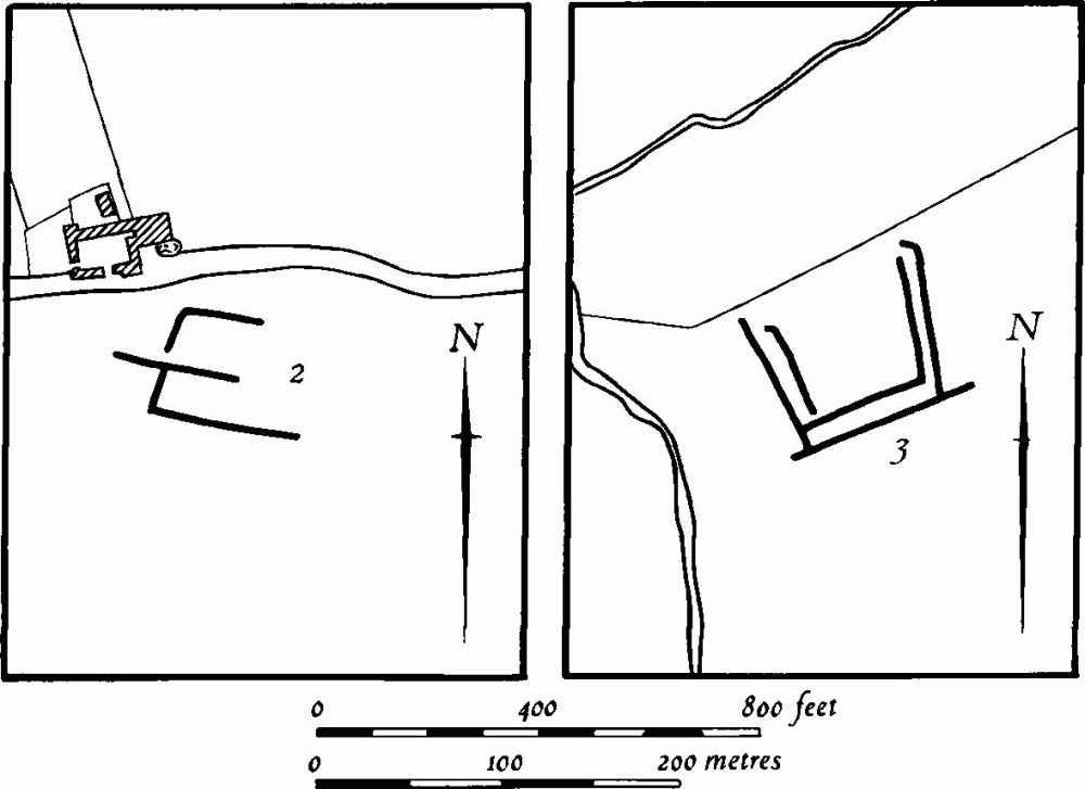
Fig. 60 Hackleton (2, 3) Cropmarks
d(9) Roman Kiln (SP 812559), 800 m. N.N.E. of the village, on Boulder Clay at 107 m. above OD. Iron Age and Roman pottery and firebars have been found on the ground. Excavation through two ditches produced, from the lower level, cordoned pottery of late Iron Age type. From the upper fill came grey ware and a bronze brooch of the 1st century. Clay firebars and flint scrapers were also found (BNFAS, 6 (1971), 13, Hackleton (4); Ant. J., 49 (1969), 95).
c(10) Roman Settlement (centred SP 817563), W. of Brafield Stadium, on Boulder Clay at 112 m. above OD. Finds include: (a) at SP 817563, Roman pottery and tiles, and coins, one of Postumus and one of Constantine I (OS Record Cards; BNFAS, 6 (1971), 13, Hackleton (1)). An iron hatchet was later found on the same site (BNFAS, 7 (1972), 21); (b) at SP 81855622, a Roman signet ring, parts of a bracelet, and a coin of the 2nd century, all of bronze (OS Record Cards; NM).
b(11) Roman Villa (SP 79785414), S.W. of Piddington, on limestone at 94 m. above OD. The remains of a substantial Roman building were found in 1968, with roof tiles, bricks, wall-plaster, tesserae, marble and pottery of the 1st to 4th centuries. This may be the site said to have been found in 1781, in some stone pits near Preston Wood (SP 791545), described in 1799 and 1874 and published by OS at SP 80775466. Any of the three sites described below, (12), (13) or (14), may be mislocations of this villa. The 1874 description lists finds of Roman tiles and pottery, a tessellated pavement, 15 m. square, and also part of a skeleton with a gold ring and a spear beside it, perhaps Anglo-Saxon. NM have no record of these earlier finds (T. Reynolds, Iter Britanniarum, (1799), 458; Whellan, Dir., 277; OS Record Cards).
b(12) Roman Building (SP 793546), N.E. of Rookery Farm, on limestone at 91 m. above OD. Roman pottery, glass, roof tiles and foundations were found in 1958 (NM Records).
b(13) Roman Settlement (SP 793540), 450 m. W.S.W. of (11), on Boulder Clay. Roman pottery and tiles have been found (BNFAS, 6 (1971), 13, Hackleton (7)).
d(14) Roman Settlement (SP 800534), in the S.W. of the parish, on Boulder Clay at 110 m. above OD. Large quantities of Roman pottery, including samian, were found in 1972 (Northants. Archaeol., 8 (1973), 14, 15).
d(15) Roman Settlement (SP 827528), W. of Horton Woods, on Boulder Clay at 107 m. above OD. A scatter of stone and Roman pottery has been found, covering about 0.5 hectares, and including samian and mortarium sherds. There was also part of a quern (BNFAS, 3 (1969), 14).
Medieval and Later
b(16) Deer Park (?) (perhaps SP 792540; Fig. 61), immediately E. of Park Farm, on Boulder Clay at 100 m. above OD. In 1228–9 Walter de Preston obtained a grant of a number of deer from Salcey Forest to stock his park at Preston. In 1660 the park was still in existence and deer were being hunted in it (J. Bridges, Hist. of Northants., I (1791), 380–1).
There are some difficulties in determining the exact location of this park. S. of Preston Wood there is a roughly circular area of just under 50 hectares, bounded by a continuous modern hedge, and this is the most likely position but no traces of a park pale or bank exist on this hedge-line. The hedges are almost entirely of thorn and may have been planted at a recent date, a process which could have involved the removal of the former pale. The present hedge-line was certainly in existence in 1839 (NRO, Tithe Map). The field names on the 1839 map give no indication that the area outlined was ever a park. Beyond it to the W., around Park Farm, there are several significant names, but the fields here do not have any traces of large banks bounding them (RAF VAP CPE/UK/1926, 3019–20).
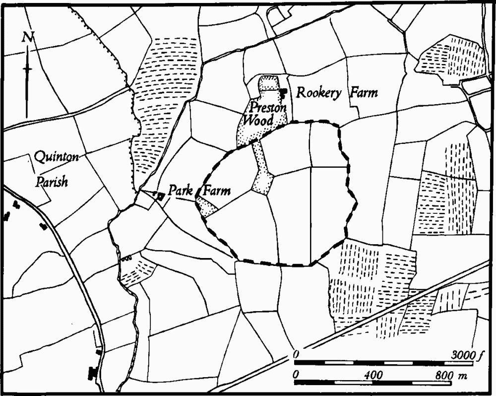
Fig. 61 Hackleton (16) Deer park
a(17) Deserted Village of Preston Deanery (SP 787555; Fig. 62), lies S. of the church, on Boulder Clay between 76 m. and 84 m. above OD.
Preston Deanery seems always to have been very small, although the size of the village is difficult to estimate since it is rarely mentioned separately in medieval taxation records. In 1086 only six people are recorded in Domesday Book (VCH Northants., I (1902), 310), and thereafter little is known of the village's history (VCH Northants., IV (1937), 279–81). In 1674 only ten people in the parish paid the Hearth Tax (PRO, El79/254/14). By the early 18th century the lordship of Preston was said to contain only ten houses 'which stood dispersed' (J. Bridges, Hist. of Northants., I (1791), 379). As these must have included the present outlying farmsteads such as The Grange, Rookery Farm, Park Farm and West Hall, the village at that time must already have been reduced to the church, hall and a few cottages. In 1801 the population of the parish was 70.
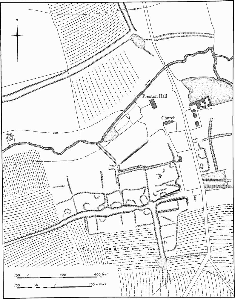
Fig. 62 Hackleton (17) Deserted village of Preston Deanery
Apart from the main hollow-ways the remains of the village are very slight and difficult to interpret. This is largely due to the fact that much of the W. part of the remains and the area immediately S.W. of the church have been ploughed at some time. The main area of former settlement S.W. of the church consists of a broad E.—W. hollow-way, up to 2 m. deep, which can be traced E. of the present road, running down to Preston Brook. On each side of this road are the very slight remains of rectangular closes, bounded by low scarps or ditches, nowhere more than 0.25 m. high. Most of the closes have shallow, irregular depressions within them which are presumably the sites of former buildings. Another hollow-way runs off the main one in a southerly direction, and this has three closes on its E. side. It can be traced for some 450 m., across the modern road, though it is much mutilated. At the E. end of the main hollow-way, just W. of the present road, there are traces of the W. side of what may once have been another hollow-way, running N. towards the church. Only a slight scarp survives, and the E. side, if it ever existed, has been destroyed by the modern boundary wall of the hall nurseries. S.E. of the church, and E. of the present road, there is a series of low, scarped rectangular platforms with ditches beyond in the valley bottom. These are probably also the sites of former buildings.
N. of the hall, on the N. side of the Preston Brook, a well-marked hollow-way extends from near the stream up the hillside towards The Grange. It can be traced for some 350 m. as a broad trackway, up to 1.5 m. deep. Near its S. end it is crossed by another, E.—W., hollowway, the E. end of which has been obliterated by modern ploughing. The existence of these hollow-ways indicates the partial extent of the medieval road system of the area, which differed considerably from the modern one (CUAP, AMX 53–9, BLF 1–4; RAF VAP CPE/UK/1926, 5018–20).
d(18) Deer Park (centred SP 825525; Fig. 63), in the S.E. of the parish, mainly on Boulder Clay between 90 m. and 107 m. above OD.
No documentary history of this park has been noted but field names on a map of Horton of 1622 (NRO), and also the surviving earthworks, suggest the existence of a large medieval park. The 1622 map shows the woodland much as it is now, with the large area between Little Horton Wood and Horton Woods named as The Parks Launde, with Parks Launde Meadow to the N. and two other 'Park' names to the S. The existing and 17th-century hedge-lines suggest the general outline of the park.
The best-preserved section of the park pale is in the N.W. corner of the park, N.W. of Little Horton Wood (SP 817526). There is a broad bank, 12 m. wide and 1.5 m. high from the inside, which is preserved in pasture, though ploughing at some period has over-run and broken down the S.W. side of the bank, giving it an asymmetrical profile. This bank extends as far as a small stream, where it is broken. Beyond this stream the bank continues across the centre of Little Horton Wood, roughly parallel to one of the rides. Here, although it has been altered by a modern drainage ditch on its inner N.E. side, it is still traceable, up to 1.5 m. high and 10 m. wide. Beyond the S. edge of the wood the boundary probably followed a modern curving hedge-line as far as the county boundary (SP 82075180), but no trace of an ancient bank remains here or along the assumed park boundary, N. to the S.E. corner of Horton Woods (SP 827519). However, just on the Buckinghamshire side of the county boundary (at SP 823513) air photographs (RAF VAP CPE/UK/1926, 1013–4) show a broad bank running roughly parallel with the existing hedge; it has been reduced by ploughing to a slight rise. Along the S.E. side of Horton Woods is a well-marked bank, 8 m. wide and 1.5 m. high, which can be traced as far as the extreme N. corner of the wood (SP 828531). The assumed boundary of the N.E. side of the park is a modern hedge-line and no trace of any bank survives. On air photographs, taken in 1947, ridge-and-furrow is visible on both sides of the hedge and appears to be cut by it (RAF VAP CPE/UK/1926, 2013). Ridge-and-furrow is also visible within the park in other places, arranged in interlocked furlongs. It appears that at least part of the area occupied by the park was once arable land and thus the park may be of late medieval origin.
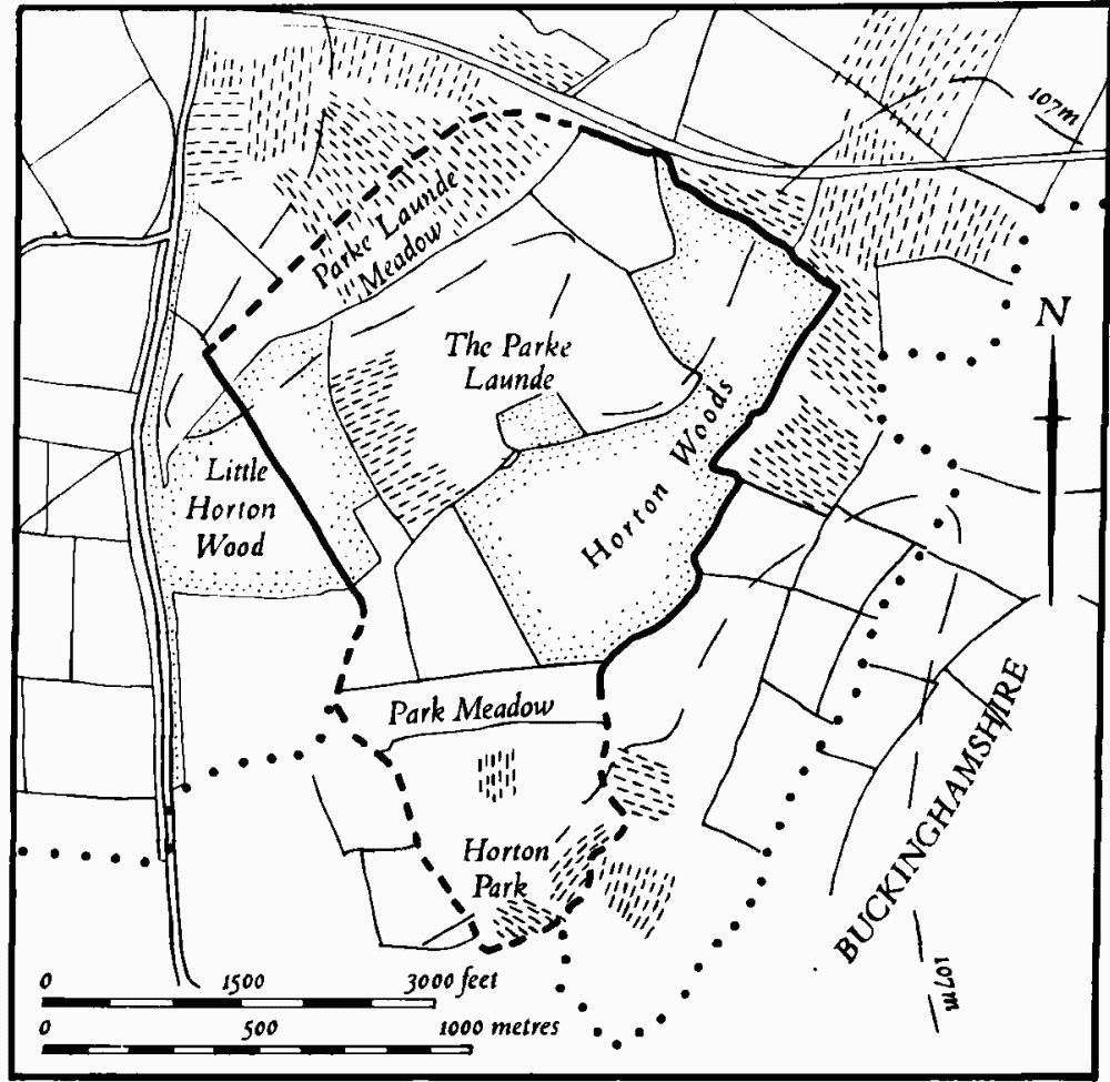
Fig. 63 Hackleton (18) Deer park
d(19) Deserted Village of Horton (centred SP 821542; Figs. 64 and 65; Plates 18, 20 and 21), to the S.E. of the present village, on either side of a small stream, which has been landscaped to form a lake, on limestone and clay at 91 m. above OD. The village was first noted in Domesday Book as being divided into several small manors, one of which was waste. At that time it had a recorded population of 18 (VCH Northants., I (1902), 340–1, 311, 351–2). Although the descent of the manors is known, little of the history of the village itself has been recorded (VCH Northants., IV (1937), 259–62). In 1348 the village paid 54s. 10d. tax (PRO, E179/155/3), the lowest amount in Wymersley Hundred, but not exceptionally low for the county. In 1524 10 and 15 people are listed as taxpayers (PRO, E179/155/125 and /142).
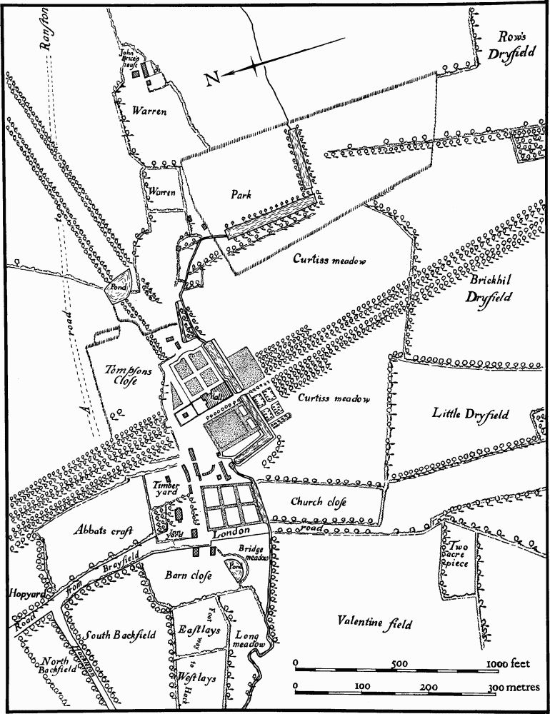
Fig. 64 Hackleton (19) Deserted village of Horton (drawing based on a plan of 1728)
The earliest map of the village (NRO, 1622; Plate 18) shows a winding through-road, extending from the present Northampton Road near the church, around the N. of the hall, and thence along the edge of the stream, before finally running up the valley side and onwards to the S.E. At that time a number of buildings existed on either side of the church and N. of the hall, while E. of the hall, along the road and along a small lane running N., there were perhaps seven scattered houses, including the present Manor Farm. The small lane running N. from the road terminated in front of a large pond, which occupied a small valley.
Soon after the map was made the manor of Horton, then comprising the whole lordship, passed into the possession of Sir Henry Montagu who was created Earl of Manchester in 1626. It remained with this family until the late 18th century. The house was probably rebuilt towards the end of the 17th century (J. Cornforth, 'Horton House, Northamptonshire', in J. Harris (ed.) The Country Seat, (1970)). George Montagu, who became the Earl of Halifax in 1715, probably landscaped the area to the N., E. and S. of the hall, and this involved the removal of the village. The exact date of this removal is not known, but it may have taken place by 1720, for Bridges, writing then, said that the whole parish contained only eight or nine families (J. Bridges, Hist. of Northants., I (1791), 367). A map of 1728 (NRO; Fig. 64), unfortunately rather mutilated, depicts what appears to be the first stage of the landscaping, with new avenues, a park and a number of rectangular ponds, all in early 18th-century style. However, the road running N. and E. of the hall still survived, together with most of the paddocks and the pond shown on the earlier map across which lies one of the new avenues. The map may in fact record a stage in the process of removal for at least four of the earlier buildings are still shown. Presumably the clearance of the village was completed soon afterwards, but the whole area was landscaped again, at a later date, to a different design. By 1801 only 79 people lived in the parish, mainly in outlying farms, and in 1874 there were three scattered farms and some cottages (Whellan, Dir., 269). In recent years development around the site of the hall, which was demolished in 1936, has led to the renewed growth of Horton.
The surviving earthworks in the old parkland E. and S. of the hall complement the documented history, but also introduce problems of interpretation because the remains are partly overlaid by later features connected with the landscaping of the area. Some of the village earthworks were even incorporated into the scheme of landscaping.
Immediately E. of the site of the hall and N. of the lake, where the 1622 map shows the road, the lane to the pond and a number of houses, little remains on the surface ('a' on Fig. 65). There are only some low scarps and banks and other indeterminate earthworks, with well-marked ridge-and-furrow to the N. To the N.W. there is a large L-shaped scarp which still stands 1.5 m. high. The S. side of this may mark the edge of the old road at this point. The other earthworks are either old closes not shown on the 1622 map, or are the result of the destruction of the village in the early 18th century. To the S.E. ('b' in Fig. 65) is a further area of earthworks, again rather indeterminate. A wide, curving ditch, up to 1.75 m. deep, which bounds them on the S. and W. sides, is likely to be part of the later landscaping work, although to the S.E. it continues as a hollow-way (Plate 21). There is a much narrower ditch, only 0.5 m. deep, cut on its W. side by the landscaped ditch, and this is likely to be the original roadway shown on the 1622 map. It twists through a series of sharp bends and then probably once joined the upper, E. part of the main curving ditch ('c' on Fig. 65). The latter ditch, though much altered, is likely to be the continuation of this road which ran on past Manor Farm.
N. of this section of the road ('d' on Fig. 65) is a series of rectangular earthworks, bounded on the N. by a broad open hollow-way, all of which lay in a field called The Warren in 1622. These earthworks appear to include at least two small rectangular areas which could be the sites of former buildings.
Quite separate from the above, S. of the hall, on the S. side of the lake ('e' on Fig. 65) is another group of earthworks which were also formerly part of Horton village. It consists of a well-marked hollow-way or street up to 1.5 m. deep, partly blocked by later dumping in the centre and cut short at the S. end by a shallow ditch and adjacent ridge-and-furrow. On either side of this hollow-way are well-marked rectangular closes within which there are several rectangular platforms, probably the sites of former houses. A quantity of pottery, all of Olney type and dated to the 13th to 14th centuries, has been found in this area.
The interpretation of these village remains poses a number of problems. The area of the village N. of the lake which was removed in the 18th century, together with the surviving earthworks to the E. in the former Warren Field, may be considered as a simple single-street village running along the valley side with church and manor house at one end. However the identification of another part of the village to the S. of the lake with its street on a different alignment and with evidence of apparent abandonment in the late medieval period makes the situation more complex. One possible explanation that has been put forward is that the village of Horton changed both its site and morphology, but this is not necessarily the only solution (C. C. Taylor, 'Settlement Mobility in Medieval and Later Times'. in CBA Research Report, The Impact of Man in the Lowland Zone (forthcoming); RAF VAP CPE/UK/1926, 3013– 16; air photographs in NMR and CUAP, BKZ 46, 48–50).
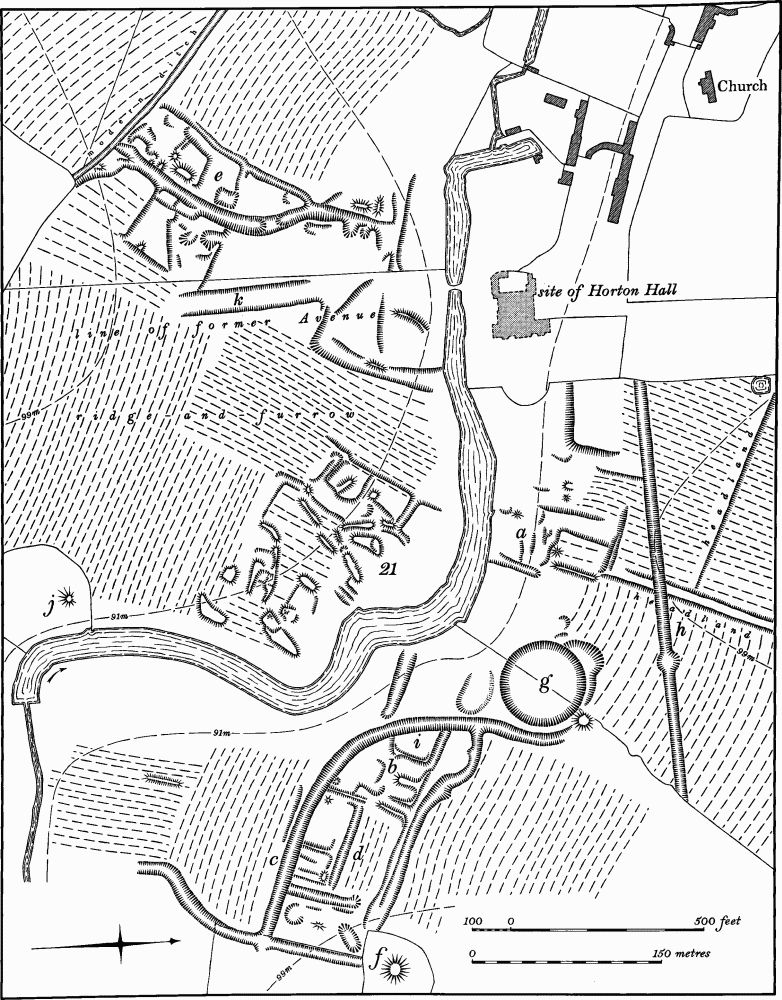
Fig. 65 Hackleton (19) Deserted village of Horton, (20) Horton Park and garden remains, (21) Mounds
d(20) Park and Garden Remains (centred SP 821539; Figs. 64, 65, 66 and 67; Plates 20 and 21), in and around the parkland associated with the former Horton Hall. The earthworks constitute only part of the remains; decorative buildings, for example the Menagerie and Temple Farm, also survive as part of the landscape design. The earliest map of the area, of 1622 (NRO; Plate 18) depicts the hall surrounded by a typical late 16th or early 17th-century garden. This included a formal garden E. of the hall, a Cherry Yard to the S. and an orchard and fishponds to the W., none of which survives. At the time that this map was made the manor passed to the Montagu family. George Montagu, who was created Earl of Halifax in 1715 (VCH Northants., IV (1937), 261), was probably responsible for removing part of the village (18) to the E. and for the first steps in landscaping the park. A map of 1728 (NRO; Fig. 64) shows this process under way but apparently not completed. The formal gardens around the house were enlarged and extended southwards beyond an L-shaped lake. Long avenues made up of several lines of trees were laid out to the N. and S., with another, simpler avenue at right-angles, to the E., fronting the hall. To the S.E. a section of the stream was turned into two rectangular ponds, at right-angles to each other. The surrounding area was enclosed by a wooden fence to provide a small deer park. Around 1740 the 2nd Earl of Halifax rebuilt the hall and carried out the more informal landscaping which partly survives today. The earthworks include a number of Mounds (e.g. 'f' on Fig. 65) around the perimeter of the park. They range in size from 2 m. to 4 m. high and from 25 m. to 60 m. across. They were constructed either as prospect mounds or for raised tree plantations (e.g. SP 826541 and 829537). There are also several circular or semi-circular ditched enclosures, again ranged around the perimeter of the park (e.g. SP 825534 and 818535). These are usually some 50 m. in diam., bounded by shallow ditches up to 0.5 m. deep. One of them, on the N. edge of the park (SP 823545) is circular and cuts through earlier ridge-and-furrow; it has a series of mounds around its perimeter, perhaps the positions of former trees, with another larger mound in the centre (Fig. 67). Other ditched features, in addition to these, are associated with existing buildings of the 1740s, around the park. The building on the S. side of the park, apparently used by Lord Halifax as a menagerie (SP 822534), lies on the N. side of an ovoid ditched feature, 100 m. by 130 m. over all. On the N.E. edge of the park the early 19th-century structure known as The Arches (SP 827542; Fig. 66; Plate 21) is flanked on its W. side by two semi-circular ditches, 0.5 m. deep. The positions of former trees are marked by a series of small pits along the inside edges of these features. Among other earthworks relating to the landscaping of the park is a large, exactly circular Pond, 2 m. deep, lying in the entrance of a small valley (SP 824542; 'g' on Fig. 65). On the maps of 1622 and 1728 (NRO; Plate 18; Fig. 64) there was another pond on this site, perhaps associated with the former village (18). Presumably the present pond was constructed sometime after 1728 but before 1740 as a feature to be viewed from the E. front of the house. It is unlikely, but not impossible, that it dates from the 1740s. There are two linear ditches within the park which are in some way connected with landscaping or water supply. N.E. of the site of the hall (SP 823542; 'h' on Fig. 65) is a broad ditch, up to 1.5 m. deep, and exactly straight, which cuts across the hillside in a W. direction and overlies the earlier ridge-and-furrow; its date and function are unknown. Further S.E. and extending from the E. side of the pond ('g') is a broad curving ditch or hollow-way, up to 1.5 m. deep, which runs up the hillside ('i' on Fig. 65). At its E. end it is on the line of the hollow-way or main street of the former village ('c' on Fig. 65), but it has been recut at a later period and re-aligned at its W. end to curve back to the pond. Again its date and function are unknown.
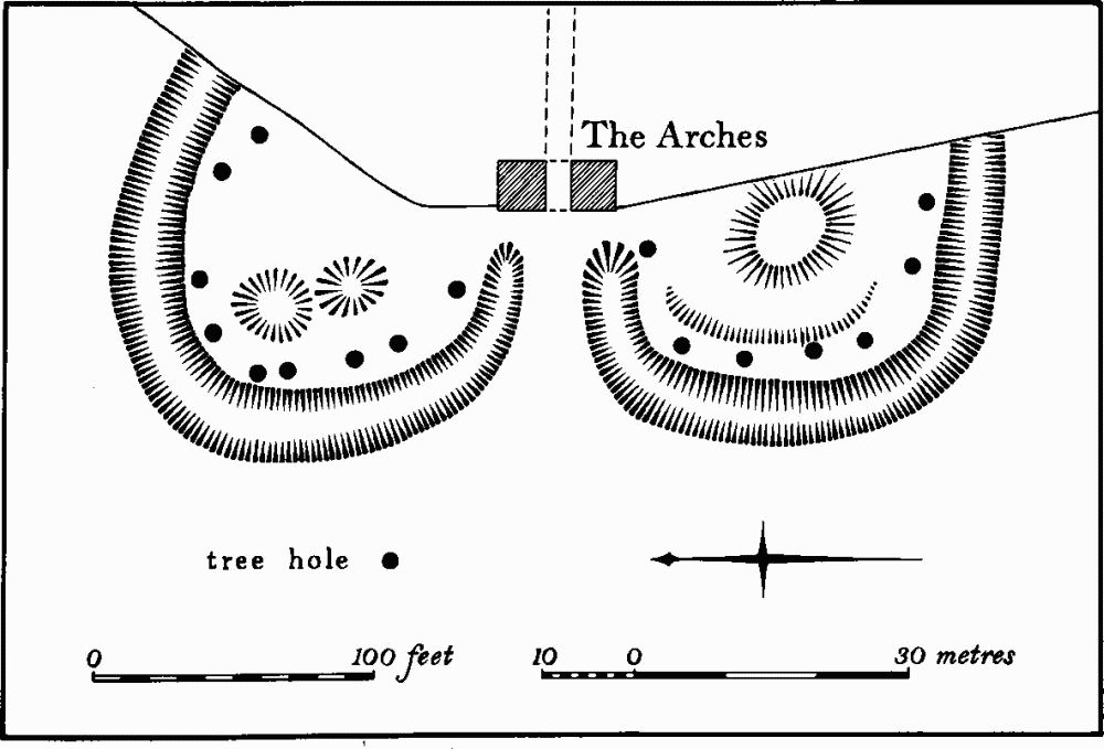
Fig. 66 Hackleton (20) Horton Park; garden remains at The Arches
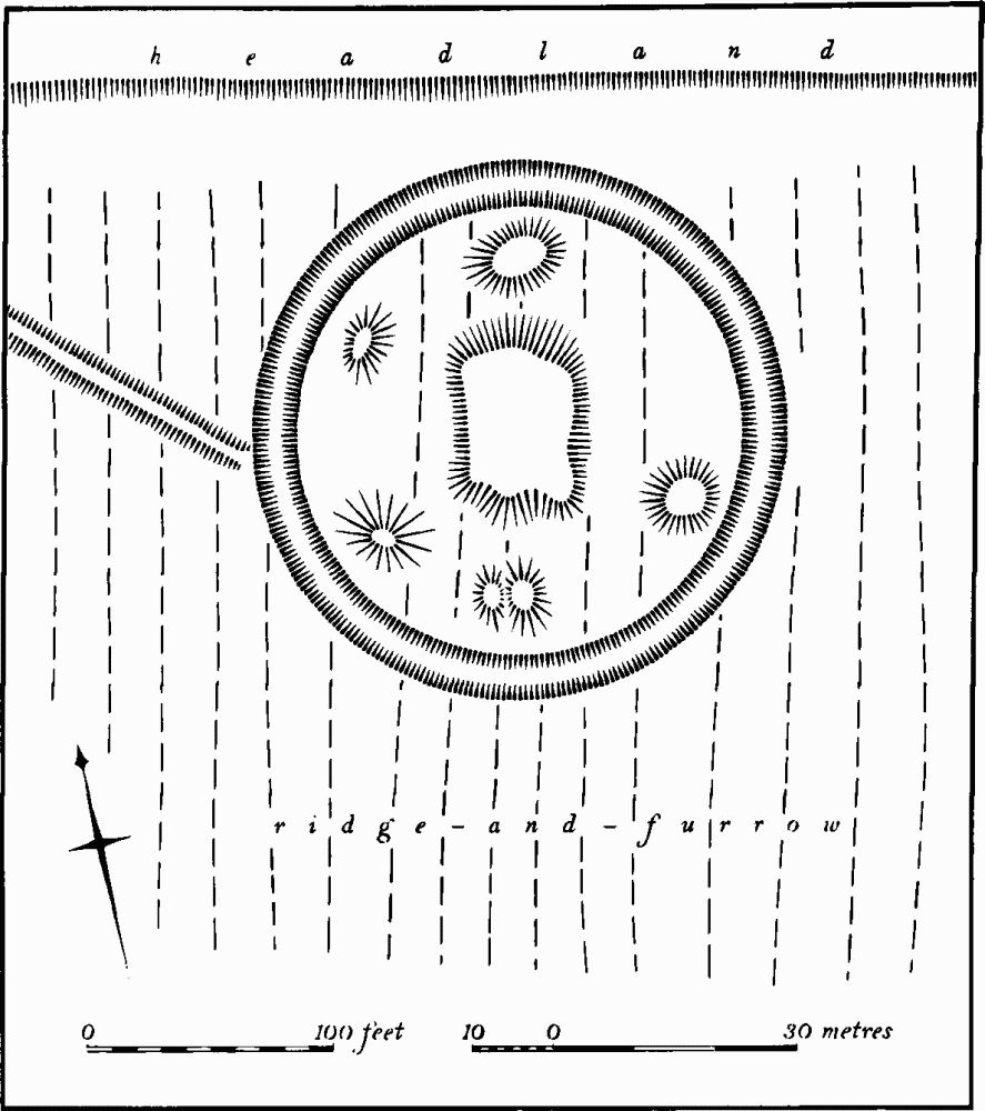
Fig. 67 Hackleton (20) Horton Park; garden remains
Other minor features in the park, connected with landscaping, include an ice-house mound ('j' on Fig. 65) and long parallel scarps or ditches marking the alignments of former avenues (e.g. 'k' on Fig. 65; RAF VAP CPE/UK/1926, 3013–4, 5014–5).
d(21) Mounds (SP 823540; Fig. 65), lie to the S. of the lake, in Horton Park. An area of some 3 hectares is covered by a series of irregular low mounds and shallow ditches, forming no coherent pattern. Though some of the features may result from indeterminate digging many of the mounds appear to have been deliberately constructed. The area was part of Curtis's Meadow on maps of 1622 and 1728 (NRO; Fig. 64; Plate 18). No date or function can be assigned to the mounds. Local tradition claims that they date from the mid 18th century when the then Lord Halifax had a private militia which carried out military exercises in the area (RAF VAP CPE/UK/1926, 3013–4; air photographs in NMR; OS Record Cards).
c(22) Settlement Remains (SP 810551), formerly part of Hackleton, lie in the N.E. part of the village on Boulder Clay at 107 m. above OD. A series of rather damaged embanked enclosures with traces of possible house-sites at their W. ends survive immediately E. of a small N.—S. lane. Sherds of medieval and later pottery have been found in this area (BNFAS, 5 (1971), 44). In 1788 (NRO, Map of part of Hackleton) a number of buildings stood in this area, within small paddocks and closes, but clearly some abandonment had already taken place by then. By 1854 (NRO, Map of Hackleton) all the buildings had disappeared. The 1854 map once had the closes marked on it but these have been removed by a later hand.
Further medieval pottery, iron slag and patches of stone have been discovered further E. (SP 813550) in an area of ridge-and-furrow. This latter site was originally described as of Iron Age date (OS Record Cards; BNFAS, 6 (1971), 13, Hackleton (6); RAF VAP CPE/UK/1926, 5015–6; CPE/UK/1994, 4188–9).
d(23) Settlement Remains (centred SP 802546), formerly part of Piddington, lie in and around the village. Piddington has a markedly rectangular grid pattern of streets and paths, with the church situated just outside the N.W. corner, and what may be a later growth of the grid to the S.E. Within and around the rectangular part of the grid there are, or were, a number of earthworks. To the S. of the manor house, on the W. side of Old End (SP 802544) were some platforms and banks which have now been built over (local inf.). N.W. of the manor house and immediately S.W. of the churchyard (SP 800545) there is a short length of hollow-way, running W. into ridge-and-furrow, with the W. end of an embanked enclosure on its S. side. In the centre of the village modern construction work led to the discovery of the stone foundations of a building, associated with 13th-century pottery (OS Record Cards; NM).
(24) Cultivation Remains. The common fields of Horton had been enclosed before 1622 (NRO, Map of Parish; Plate 18). Ridge-and-furrow of these fields exists on the ground or can be traced from air photographs over almost all of the northern two-thirds of the old parish. It is specially well-preserved around Horton Park, surrounding the site of the former village (19). It is arranged in interlocked furlongs, many of markedly reversed-S form. In the S. of the old parish, within the area of the deer park (18), as well as beyond it to the S.E., there are further traces, also arranged in interlocked furlongs (SP 825515, 821524 and 828515). This suggests that large areas were under cultivation at some period. Part of this land was, in medieval times, a detached part of Cogenhoe parish.
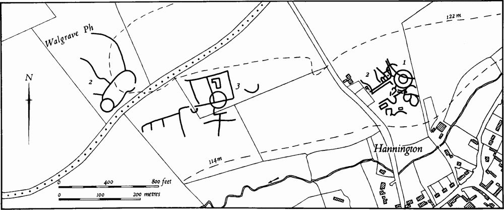
Fig. 68 Hannington (1) Ring ditch, (2) Roman settlement, (3) Cropmarks Walgrave (2) Cropmarks
The common fields of the old parishes of Hackleton and Piddington were apparently enclosed in 1783, by Act of Parliament of 1782 (NRO, Letter attached to a map of parts of Piddington and Hackleton, 1788). Ridge-and-furrow of these fields can be traced over most of the N. half of the old parish, and even where it no longer exists the old headlands can still be seen as low ridges up to 600 m. long (e.g. at SP 814555). The ridge-and-furrow is arranged in end-on and interlocked furlongs, with a marked tendency for the ridges to run at right-angles to the numerous small streams in the area. On the map of 1788, which covers only the N. part of the parish, the recently enclosed strips, access-ways and headlands are depicted, and these agree exactly with what remains on the ground or is visible on air photographs. The S. part of the parish is largely occupied by woodland, part of the old Salcey Forest, and no ridge-and-furrow has been noted here, except in the extreme S.E. (at SP 814517) where there is a long strip of arable land alongside the forest edge. Fields in this area called the Assarts (NRO, Tithe Map of Piddington, 1851) indicate medieval clearance, and certainly 460 acres of ancient assarts were listed in Piddington in 1635 (P. A. J. Pettit. 'The Royal Forests of Northants.', Northants. Record Soc., 23 (1969), 150).
The enclosure of the common fields of Preston Deanery had certainly taken place by the early 18th century but the exact date is unknown (VCH Northants., IV (1937), 279). Ridge-and-furrow exists on the ground or is visible on air photographs over almost the entire parish (centred SP 785566). It is well marked in the N.W. of the parish where the existing fields were known in 1742 as The Warren, and in the S. of the parish within the area of the medieval deer park (16) (RAF VAP CPE/ UK/1926, 1013–21, 2014–21, 3010–22, 5013–21; CPE/ UK/1994, 3176–8, 2181–8, 4064–9, 4185–90).