An Inventory of the Historical Monuments in the County of Northamptonshire, Volume 2, Archaeological Sites in Central Northamptonshire. Originally published by Her Majesty's Stationery Office, London, 1979.
This free content was digitised by double rekeying. All rights reserved.
'Wellingborough', in An Inventory of the Historical Monuments in the County of Northamptonshire, Volume 2, Archaeological Sites in Central Northamptonshire(London, 1979), British History Online https://prod.british-history.ac.uk/rchme/northants/vol2/pp166-170 [accessed 28 April 2025].
'Wellingborough', in An Inventory of the Historical Monuments in the County of Northamptonshire, Volume 2, Archaeological Sites in Central Northamptonshire(London, 1979), British History Online, accessed April 28, 2025, https://prod.british-history.ac.uk/rchme/northants/vol2/pp166-170.
"Wellingborough". An Inventory of the Historical Monuments in the County of Northamptonshire, Volume 2, Archaeological Sites in Central Northamptonshire. (London, 1979), British History Online. Web. 28 April 2025. https://prod.british-history.ac.uk/rchme/northants/vol2/pp166-170.
In this section
62 WELLINGBOROUGH
(OS 1:10000 aSP 87 SE, bSP 97 NW, cSP 86 NW, dSP 86 NE, eSP 96 NW)
The modern parish, of some 3800 hectares, now includes the old parish of Finedon and part of Irthlingborough. It lies N.W. of the R. Nene, which forms its S. boundary, and is bisected by the S.-flowing R. Ise which joins the Nene just S.E. of Wellingborough town. Both rivers flow in broad, open valleys at around 45 m. above OD, with wide expanses of Jurassic clays exposed on the lower valley slopes. On the higher ground large areas of Oolite Limestone and Northampton Sand are exposed, which are in turn overlaid by Boulder Clay in the extreme N. and S.W. of the parish, here at just over 90 m. above OD. The parish contains a large number of prehistoric and Roman settlements, the most important of which are those to the W. of Wellingborough (10–14). Fieldwork and excavation in advance of and during large-scale urban expansion here have revealed a notable complexity of occupation in an area hitherto regarded as largely devoid of early settlement.
Prehistoric and Roman
A Neolithic flint axe was found at Finedon before 1878 (lost; Arch. J., 35 (1878), 265). Part of a large Scandinavian-type adze of rectangular section, perhaps an ancient import, was found in Jackson's Lane, Wellingborough in 1956 (Plate 31; SP 888680; NM). Four bronze axes were recorded from Wellingborough, one before 1837, the other three, described as socketed, about 1871 (lost; T.J. George, Arch. Survey of Northants., (1904), 21; J. Cole, Hist. of Wellingborough, (1837), 141). A bronze palstave, found during housing development in 1966, is in KM (SP 868678; BNFAS, 2 (1967), 6). A bronze socketed spearhead with side loops found about 1972–3 (at SP 90977218) is now in private hands (Northants. Archaeol., 10 (1975), 150). A Roman vase (NM) is said to have come from Finedon and may be from one of the sites listed below (VCH Northants., I (1902), 217). Three Roman coins are also said to have been found in Wellingborough in 1960. A possible ritual pit lined with limestone and containing deer bones, associated with several Roman 'Vases', is recorded from Wellingborough. Its location is not known, but it may have been part of one of the Roman sites listed below (A. Ross, Pagan Celtic Britain, (1967), 273).
b(1) Ring Ditch (SP 91007040; Fig. 148), on sand at 63 m. above OD. Air photographs (in NMR) show a ring ditch 35 m. in diam.
b(2) Ring Ditch and Enclosures (SP 90987027; Fig. 148), 120 m. S. of (1) in a similar position. Air photographs (in NMR) show a ring ditch 47 m. in diam., with an eccentric rectangular feature within it as well as a series of small conjoined enclosures to the S. and intersecting it. A quantity of fine worked flints has been found in the area, including several cores and a barbedand-tanged arrowhead (BNFAS, 1 (1966), 20; 2 (1967), 32; 4 (1970), 4, 11; 6 (1971), 11).
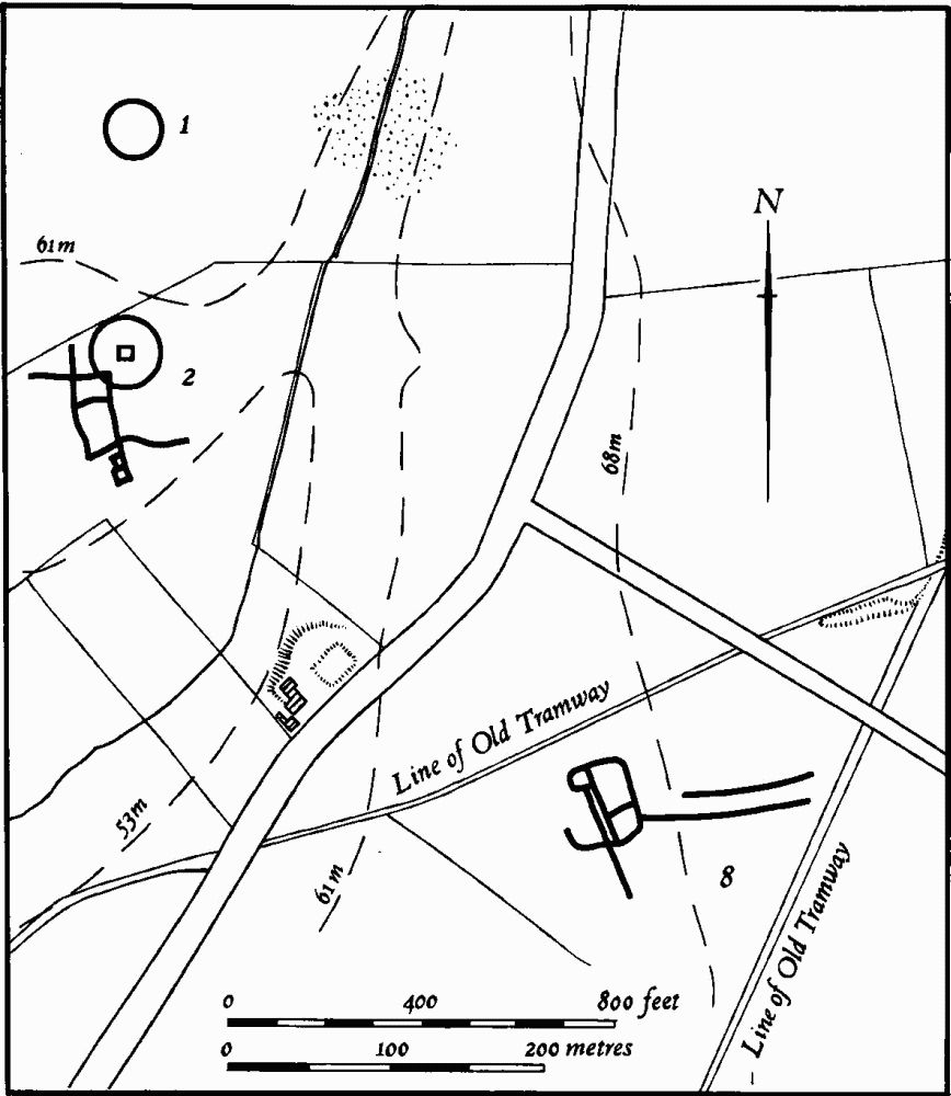
Fig. 148 Wellingborough (1) Ring ditch, (2, 8) Cropmarks
(3) Bronze Age Burials (unlocated). There are records of three 'Bronze Age Cinerary Urns' from Finedon (OS Record Cards) but only one is mentioned in NM Records (lost).
e(4) Worked Flints (SP 927692), found by fieldwalking S.W. of Stone Cross Cottage, on Northampton Sand at 83 m. above OD (BNFAS, 7 (1972), 8).
b(5) Enclosures (SP 930724; Fig. 151), E. of Finedon, on Boulder Clay at 91 m. above OD. Air photographs (in NMR) show two sub-rectangular enclosures, one with an entrance to the S.E. Between them is a length of ditch running N.E.—S.W., to which is linked, by a curving length of ditch, a roughly circular enclosure with an entrance on the S.E. side (BNFAS, 6 (1971), 11, Finedon (3); Beds. Arch. J., (1972), 13, Finedon (4)).
e(6) Enclosure (SP 923693), W. of Stone Cross Cottage, on Northampton Sand at 76 m. above OD. An air photograph (CUAP, ZE 15) shows a sub-rectangular enclosure, curved at one end (BNFAS, 6 (1971), 18).
e(7) Enclosures (SP 923687; Fig. 149), E. of South View Farm, on Northampton Sand at 60 m. above OD. Air photographs (CUAP, ZA 61, 63, ZE 14) show three enclosures, the largest of which is roughly circular and double-ditched with a number of pits and other features inside it. To the N.E. of this enclosure part of another is visible. To the S. is a third, of irregular shape with internal divisions.
b(8) Enclosures (SP 913700; Fig. 148), 500 m. W. of Carrol Spring Farm, on sand at 64 m. above OD. Air photographs (in NMR) show a number of rectangular ditched features, which are almost certainly the result of natural frost action, covering an area of 4 hectares. However, there are also indications of a small group of conjoined rectangular enclosures, possibly a settlement, lying in the centre (at SP 91297001). Two abandoned ironstone tramways cross the area.
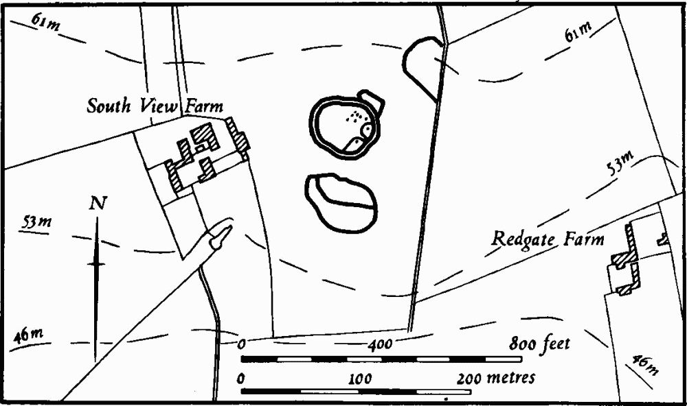
Fig. 149 Wellingborough (7) Cropmarks
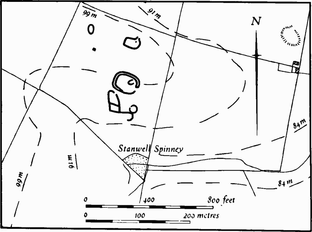
Fig. 150 Wellingborough (9) Cropmarks
d(9) Enclosures (SP 871694; Fig. 150), N. of Stanwell Spinney, on limestone at 99 m. above OD. Air photographs (CUAP, AGE 3–5) show a group of enclosures. There is a circular double-ditched enclosure with an entrance to the E.; to the S. and N. of this are two subrectangular enclosures with entrances. The S. one is sub-divided; it is attached by a linear ditch to a circular feature on the E. There is one other small ovoid enclosure in the same field. N.W. of the main enclosure is a small, rectangular pit or sunken hut. Ridge-and-furrow lies over these. A scatter of medieval pottery has been found on the surface (BNFAS, 5 (1971), 26–7; Rescue Publication 2, Northampton—Wellingborough Expressway Survey, (1972), map 6).
d(10) Iron Age Settlement (SP 89306945), N.W. of Nest Farm, on sand at 70 m. above OD. During building operations in 1971 two parallel, curved, linear ditches, perhaps a trackway, were discovered, with a circular ditch, probably a hut-site, and various other small pits. All contained late Iron Age pottery. Part of an iron knife was also found (BNFAS, 7 (1972), 8–9; Northants. Archaeol., 8 (1973), 5).
d(11) Iron Age Settlement (SP 899698), on Finedon Road Industrial Estate, on sand at 60 m. above OD. During building development in 1971 a number of pits and ditches were noted, all containing late Iron Age pottery. A flint tanged arrowhead was also found (BNFAS, 7 (1972), 9–10). Other similar finds have come from the same area, but are not exactly located (Northants. Archaeol., 10 (1975), 152).
d(12) Iron Age and Roman Settlement (SP 873674), N. and E. of Westfield Lodge, on limestone at 91 m. above OD. Air photographs (CUAP, ZW 41–3; RAF VAP F21 543/RAF/943, 0098–9) show a series of sub-rectangular and circular enclosures associated with lengths of ditch. During development of the site for housing between 1965 and 1967 a number of finds were made in this area. These included Iron Age and Roman ditches, limestone and burnt cobbles, large quantities of Iron Age and Roman pottery scattered over a wide area, a Roman well 4.2 m. deep, and a quantity of medieval pottery (see (28) below; KM; BNFAS, 2 (1967), 20; 3 (1969), 6; Northants. Archaeol., 10 (1975), 142–4; OS Record Cards). A Roman coin is also recorded from the area (SP 87306762; OS Record Cards).
d(13) Iron Age and Roman Settlement (centred SP 875680), on Boulder Clay at 91 m. above OD. Air photographs (not seen by RCHM) are said to show two large rectangular enclosures (at SP 876679). During housing development in this area a large amount of material has come to light including the following:
(a) at SP 876679, Roman pottery of the mid 2nd to mid 3rd centuries, including samian, fragments of bronze, four coins, clay and limestone roof and floor tiles, as well as medieval pottery, (BNFAS, 2 (1967), 20, 28–9). Six pottery kilns have also been excavated here (Britannia, I (1970), 288).
(b) at SP 875681, some 12 hectares of land with a number of rectangular enclosures dating from the late Iron Age to the 2nd century A.D. There were pits and ditches, two Roman pottery kilns of mid 1st-century date, one corn-drying oven, one certain and two probable Roman lime kilns and part of a stone building (BNFAS, 4 (1970), 5, 13; 5 (1971), 27; 7 (1972), 33–7; Britannia. I (1970), 288; 2 (1971), 266; 5 (1974), 262–81; DOE Arch. Excavations 1969, (1970), 20).
(c) at SP 873682, a complex of ditches, one forming the S. corner of an enclosure, together with a flatbottomed trench and a double post-hole setting, possibly for a gateway, discovered during building work. The associated pottery was of late Iron Age type (Northants. Archaeol., 9 (1974), 86).
d(14) Iron Age and Roman Settlement (SP 87956755), near Weavers Road, on limestone and Boulder Clay at 80 m. above OD. During housing development in 1969–71 a number of ditches and pits containing early Iron Age and Roman pottery were discovered. A fragment of a human skull was also found (BNFAS, 6 (1972), 8; Northants. Archaeol., 10 (1975), 138–42; OS Record Cards).
For Saxon finds, see (26).
d(15) Iron Age and Roman Settlement (SP 864697), W. of Wellingborough Grange, on limestone at 98 m. above OD. A wide scatter of stone, together with Iron Age and Roman pottery including samian, has been found (BNFAS, 7 (1972), 8).
b(16) Iron Age and Roman Settlement (SP 924712), S.E. of Finedon, on Boulder Clay at 85 m. above OD. An area of some two hectares is covered with early Iron Age and Roman occupation debris and pottery. Several areas of stone and pebbles have been interpreted as hut-sites (Beds. Arch. J., 7 (1972), 13, Finedon (5); Northants. Archaeol., 8 (1973), 4; CBA Group 9, Newsletter, 3 (1973), 32).
b(17) Iron Age and Roman Settlement (SP 932714), in the N.E. of the parish, on Boulder Clay at 91 m. above OD. Patches of dark soil and stone have been found, containing pottery of late Iron Age and early Roman type (BNFAS, 1 (1966), 7).
d(18) Roman Settlement (?) (SP 885695), on sand at 85 m. above OD. Roman pottery and a few waste flakes have been found (BNFAS, 2 (1967), 20).
d(19) Roman Settlement (?) (perhaps SP 887684), in Harrowden Road, Wellingborough, on Boulder Clay at 83 m. above OD. Roman pottery, including samian, was found in this area before 1837 (J. Cole, Hist. of Wellingborough, (1837), 138).
d(20) Roman Building (SP 888657), in the S. of the parish, on limestone and clay at 76 m. above OD. In 1966 a pipeline trench revealed the corner of a stonewalled building associated with Roman pottery and stone roof tiles (BNFAS, 1 (1966), 15; Rescue Publication 2, Northampton-Wellingborough Expressway Survey, (1972)). Subsequently another pipeline to the S., along the parish boundary with Great Doddington, revealed at least five ditches all containing Roman pottery (inf. P. Foster). A Roman coin of Carausius is also recorded from the area (Northants. Archaeol., 8 (1973), 17).
For Saxon settlement on this site, see (27) below.
b(21) Roman Settlements (SP 911704 and 912703; Fig. 148), on either side of a small stream, on sand at 60 m. above OD. Two small areas of building-stone and Roman pottery, including samian, are recorded (BNFAS, 2 (1967), 9–10; Beds. Arch. J., 7 (1972), 13, Finedon (1)).
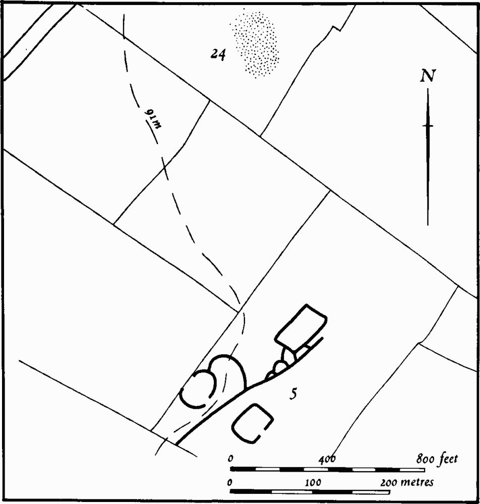
Fig. 151 Wellingborough (5) Cropmarks, (24) Roman settlement
b(22) Roman Settlement (SP 924705), S. of Finedon, on Boulder Clay at 85 m. above OD. A large area of land is covered with Roman pottery and building-stone (Beds. Arch. J., 7 (1972), 13, Finedon (6); Northants. Archaeol, 8 (1973), 6; CBA Group 9, Newsletter, 3 (1973), 32).
b(23) Roman Settlement (SP 927718), E. of Finedon, on Boulder Clay at 94 m. above OD. A scatter of Roman pottery and limestone is recorded (Beds. Arch. J., 7 (1972), 13, Finedon (3); Northants. Archaeol., 8 (1973), 6; CBA Group 9, Newsletter, 3 (1973), 32).
b(24) Roman Settlement (SP 930730; Fig. 151), N.E. of Finedon, on Boulder Clay at 94 m. above OD. A scatter of Roman pottery, limestone and pebbles has been found (Northants. Archaeol., 8 (1973), 6; CBA Group 9, Newsletter, 3 (1973), 32).
e(25) Roman Settlement (?) (SP 913695), S.W. of Finedonhill Farm, on sand at 54 m. above OD. Several sherds of Roman pottery were found here in 1969 (BNFAS, 4 (1970), 8). More pottery has been found subsequently.
Medieval and Later
Part of an Anglo-Saxon bone comb was found at Finedon before 1904 (NM; T.J. George, Arch. Survey of Northants., (1904), 15). A silver penny of Edward the Confessor and a silver coin of Offa are both recorded from Wellingborough (lost; VCH Northants., I (1902), 257; Trans. Leics. Arch. Soc., 4 (1878), 327). A quantity of late medieval pottery has been found in a trench along High Street, Finedon (SP 918722; Northants. Archaeol., 9 (1974), 105; NM).
d(26) Saxon Site (SP 87956755), found during excavations at (14). A gully packed with limestone and containing a small quantity of Saxon pottery was excavated (Northants. Archaeol., 10 (1975), 138–42).
d(27) Saxon Settlement (SP 888657; Fig.14), in the S.W. of the parish, on Boulder Clay at 80 m. above OD. At least thirty sherds of early Saxon pottery have been found here in addition to the Roman material (20). The site extends into Great Doddington parish (inf. G.R. Foard).
d(28) Saxon Settlement (?) (SP 893654; Fig. 14), 700 m. S.E. of (27), on Boulder Clay at 45 m. above OD. Early Saxon sherds have been found over an area of nearly 2 hectares. More pottery of the same type has been found to the S. in Great Doddington parish (SP 894654; inf. G.R. Foard).
e(29) Viking Finds (SP 90816966), found at Finedon Bridge over the R. Ise, during bridge-widening in 1926. Animal bones, two iron spearheads, one iron knife and one stirrup, all classified as Viking, were discovered (NM; OS Records).
d(30) Occupation Sites (centred SP 875675), associated with (12) and (13). Rubbish pits containing medieval pottery have been exposed in pipeline trenches at SP 876679, and further medieval pottery has been discovered at SP 872675 and 871680 (BNFAS, 2 (1967), 20, 28–9).
d(31) Occupation Sites. Various medieval pits and ditches have been found during re-development work within the area of medieval Wellingborough (e.g. at SP 88756770, 88856833, 89156790, 89206770; BNFAS, 7 (1972), 52; Northants. Archaeol., 9 (1974), 111; 10 (1975), 171).
(32) Occupation Sites (unlocated). Medieval pottery, roads, house platforms and wells have been noted in Finedon (DMVRG 16th Annual Report, (1968), 5).
b(33) Hollow-Way (SP 90957145–91407183) lies immediately S.W. of Finedon village within the park of Finedon Hall. It extends from the end of Regent Street alongside a small stream into the area occupied by the former Neasdale Field before enclosure. It presumably represents the line of one of the main through roads of the parish and was perhaps abandoned in the 18th century when the park was made. It is up to 15 m. wide and 1.5 m. deep.
d(34) Mound (SP 865695), 150 m. W. of Wellingborough Grange, on Boulder Clay at 104 m. above OD. A low circular mound, 15 m. in diam., with a large depression in the centre and a shallow encircling ditch overlies ridge-and-furrow (RAF VAP CPE/UK/1925, 1357–8).
(35) Cultivation Remains. The common fields of the parish were enclosed by Act of Parliament of 1765 (VCH Northants., IV (1937), 135). A survey of 1320 names three open fields, Southfield, Opfield and Eastfield (F.M. Page, 'Wellingborough Manorial Accounts' 1258–1323, Northants. Record Soc., VIII (1936), 24). Ridge-and-furrow of these fields can be seen, on the ground or on air photographs, in the W. of the parish, though much of this has now been built over. In this area the furlongs were mostly arranged end-on in a band to the S. of the Sywell Road, and interlocked to N. and S. of this band. There is a small area of interlocked and end-on furlongs against the S. boundary of the parish (centred SP 893656), and fragments of ridge-and-furrow are also traceable N. of the town.
The common fields of the old parish of Finedon were enclosed by Act of Parliament of 1805 (NRO, Enclosure Map, 1807). Immediately prior to this date there were twelve named fields, Sallow Side, North East, South East, Town Side, Upper, West, South Hill, Calwell Hill, Ryeborough Hill, Neasdale, Wells Hill and North Side Fields. The whole parish appears to have been under cultivation at the time of enclosure, with the exception of the meadows along the R. Ise in the W. and a small area of Old Enclosures round Westfield Lodge (SP 902725). Ridge-and-furrow can be traced on the ground or from air photographs over part of these fields. It has survived best in the fields N., E. and S.E. of Finedon village where it is in interlocked and end-on furlongs, some of reversed-S form (e.g. SP 925734 and 935724; RAF VAP F22 540/RAF/1312, 0277–87, 0245–57, 0198–0205, 0170–76; F21 540/RAF/1312, 0245–57, 0020–5; 541/611, 3062–70, 4062–70, 4071–9).