An Inventory of the Historical Monuments in Dorset, Volume 2, South east. Originally published by Her Majesty's Stationery Office, London, 1970.
This free content was digitised by double rekeying. All rights reserved.
'Settlements', in An Inventory of the Historical Monuments in Dorset, Volume 2, South east(London, 1970), British History Online https://prod.british-history.ac.uk/rchme/dorset/vol2/pp508-512 [accessed 17 April 2025].
'Settlements', in An Inventory of the Historical Monuments in Dorset, Volume 2, South east(London, 1970), British History Online, accessed April 17, 2025, https://prod.british-history.ac.uk/rchme/dorset/vol2/pp508-512.
"Settlements". An Inventory of the Historical Monuments in Dorset, Volume 2, South east. (London, 1970), British History Online. Web. 17 April 2025. https://prod.british-history.ac.uk/rchme/dorset/vol2/pp508-512.
SETTLEMENTS
The sites described in this section are open or unenclosed settlements, probably prehistoric or Romano-British, with earthwork remains in the form of hut-sites, closes, terrace-ways, etc. Other less well-defined settlements or settlement areas, closely associated with 'Celtic' fields, are noted here but are described under the Ancient Field Groups. Additional evidence of settlement comes from finds of occupation material unassociated with earthwork remains: most of these sites were occupied in the Roman period and are listed in the Roman section; those with prehistoric material only are listed on pp. 511–12. Known mediaeval settlement remains are described in the parish inventories.
Within the area covered by this volume only five certain settlements have survived to be recorded as earthworks, of which one, Winterbourne Steepleton (64), has since been destroyed. Only Church Knowle (54) and Winterbourne Steepleton (64) lie on chalk. The former, shown by test excavation to be Iron Age 'A', consists of a series of poorly-defined, shallow scoops on the N. brow of Knowle Hill in an area confined within cross-dykes. Finds and the absence of 'Celtic' fields suggest that it may have been a predominantly pastoral settlement. The latter comprises a group of circular hut-platforms and poorly defined irregular enclosures lying within an area of 'Celtic' fields, though not clearly related to them. Circular hut-platforms, either singly or in groups, among 'Celtic' fields are found chiefly in W. Dorset and beyond. Such settlements are in the native tradition and are probably Iron Age in origin rather than later. The remaining settlements are on limestone in the Isle of Purbeck. Corfe Castle (221) and (222) are small settlements, probably no more than farms, side by side within the same group of limestone-walled 'Celtic' fields; Church Knowle (55) is of unusual form, comprising a block of small, platformed enclosures.
The known distribution of settlement for the Iron Age and Romano-British periods is shown, together with the known areas of 'Celtic' fields, on the half-inch physical background map (opp. p. 634). This distribution is the product of chance survival and probably bears only a very limited resemblance to the original distribution of Iron Age and Romano-British occupation. Settlements have survived for the most part in areas remote, or well away from, mediaeval and later settlements, generally on the higher ground where arable activity over the past one and a half millennia has been negligible. On the lower ground, especially around modern settlements, permanent cultivation, from at least the early mediaeval period onwards, has largely destroyed the remains of earlier occupation. Two points are, however, clear from the distribution map: the high density of settlement, especially in the Roman period, in the Isle of Purbeck, and the almost complete absence of settlement from the poorer soils of the Tertiary sands and gravels, today largely covered by heath and woodland.

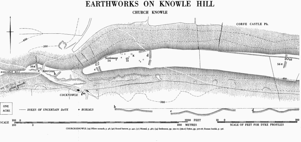
Earthworks on Knowle Hill, Church Knowle
Detailed knowledge of the economy of Iron Age and Romano-British rural settlements is wanting, but in Wessex generally a mixed farming economy almost certainly predominated. Settlements devoted solely or largely to specific activities such as shale or salt working would have formed but a minority. The relative importance of arable to pastoral farming, either generally or on any one site, remains unknown; and large areas of 'Celtic' fields associated with settlements need not imply an economy almost entirely dependent on arable farming. Trackways leading from enclosures and 'open spaces' around settlements outwards through arable fields suggest the movement of stock, while the considerable quantities of pottery, particularly Romano-British pottery, found scattered over 'Celtic' fields and usually thought to have been spread with manure, imply the existence of numerous domesticated animals.

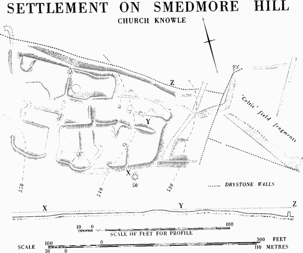
Settlement on Smedmore Hill, Church Knowle
Bere Regis
Probable Settlement, see Ancient Field Group (30a).
Probable Settlement, near Elderton Clump, see Ancient Field Group (31).
Chaldon Herring
Possible Settlement Areas, associated with 'Celtic' fields, see Ancient Field Group (15).
Church Knowle
(54) Settlement, of Iron Age 'A', on Knowle Hill (SY 98 SW; 93568224; Plate 212), lay within an area of 4½ acres between cross-ridge dykes on the summit and N. shoulder of the chalk ridge about 470 ft. above O.D. (see Dykes, Church Knowle (56c,d)). Extensions of the dykes towards each other on the N. suggest an unfulfilled intention to enclose the whole area, but the arrangement of the two parts of dyke (d), with the ditch on different sides, can be matched in a settlement on Muston Down, Winterborne Kingston (Dorset III, forthcoming).
Ill-defined scoops are found over one acre only, on the N shoulder, but excavation of the clearest and largest of these, (x), showed that occupational material had been washed into it from the crest of the hill above. Abundant finds here indicated an economy dependent upon cattle, though there was also much evidence for the working of Kimmeridge shale. (Dorset Procs., LXXIX (1957), 106–7.) The arrangement of dykes (56a, b, e), to E. and W. of those enclosing the settlement, suggests pastoral usage as does the absence of 'Celtic' fields. A mound, Church Knowle (51), might be associated with the settlement. Ditched banks, up to 24 ft. across and 2 ft. high, running up the N. side of the ridge on a slope of up to 26°, are undated and of uncertain purpose though such banks are occasionally found in a similar relationship to hill-forts (cf. Chalbury, Bincombe (76)).
(x), a roughly circular area about 24 ft. across, was dug during the Iron Age into a natural N. slope of 9°. Whatever its origins, it eventually had a flat floor about 11 ft. across 3½ ft. below the surface on the uphill side. In this floor were four post-holes, 9 ins. in diameter and arranged in a square with sides of 8 ft., that probably held roof supports. The pottery is all coarse with relatively little finger-tip decoration but no sign of Iron Age 'B' influences.
(55) Settlement, probably prehistoric and Romano-British (SY 97 NW; 931796; Fig. p. 509), in Ancient Field Group (20), covers just over 1 acre at about 540 ft. above O.D. on a gentle N. slope of Smedmore Hill, a limestone ridge, where the main fall is E. towards a valley-head. The settlement consists of a block of small enclosures unlike any other in Dorset. These enclosures are platformed, bounded by scarps or banks up to 2½ ft. high; some seem to contain limestone rubble. A mound just S. (see Mounds, Church Knowle (50)) may be connected with the settlement but any extension on this side has been obliterated by ploughing in narrow rig. Iron Age 'A' and Romano-British pottery, samian to late coarse ware, came from a pipe trench (Dorset Procs. LXXVIII (1956), 76) at the extreme E. of the settlement where it seems to be linked to 'Celtic' fields. The short, straight lengths of scarp along the N. side of the settlement further suggest that 'Celtic' fields ran up to it. (R.A.F. V.A.P. CPE/UK 1821: 5415.)
Corfe Castle
Note: The two settlements, (221–2) below, lie in close relationship on Kingston Down within Ancient Field Group (23) (Fig. p. 631). They are so integrated with the fields that their precise limits are uncertain.

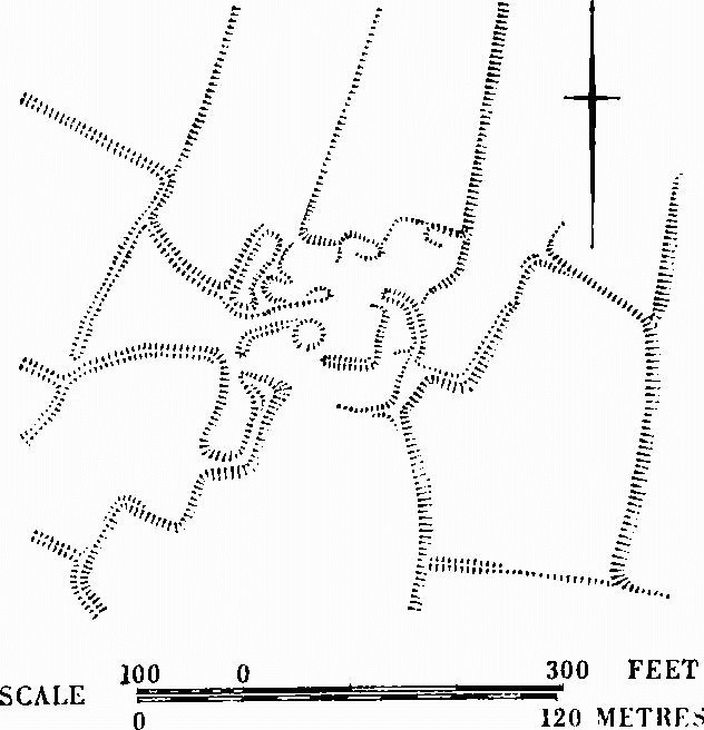
Corfe Castle (222)

Corfe Castle (221)
(221) Settlement, prehistoric or Romano-British (SY 97 NE; 957781; Plate 235), covers up to 6 acres just over 400 ft. above O.D. on the almost flat, exposed top of the limestone coastal plateau. It comprises a series of closes marked by low turf-covered banks and includes at least two hut-circles, one embanked and 17 ft. across with an entrance on the E., and another, slightly sunken, 20 ft. across. Between the hut-circles a stretch of track runs for 30 yds. E.-W. and opens into a close.
(222) Settlement, prehistoric or Romano-British (SY 97 NE; 960779; Plate 235), covers 3 acres or more about 250 yds. S.E. of (221), on the same limestone plateau. The ground falls steeply S. and E. from it. Two shallow circular depressions about 22 ft. and 27 ft. across lie 120 ft. apart in an area of disturbed closes, some with curved sides, defined by low banks. Iron Age 'C' or Romano-British sherds were found on the surface. Two tracks lead from it: one W.S.W. to the S. tip of the plateau, where rough platforming suggests a further possible area of settlement, and a second S.W. diagonally downhill for 250 yds. between 'Celtic' fields before being lost in an area of landslip.
Lulworth, West
Possible Settlement Areas associated with 'Celtic' fields, see Ancient Field Group (15).
Owermoigne
Possible Settlement Area associated with 'Celtic' fields, see Ancient Field Group (11).
Winfrith Newburgh
Probable Settlement Area associated with 'Celtic' fields, see Ancient Field Group (15).
Winterbourne Steepleton
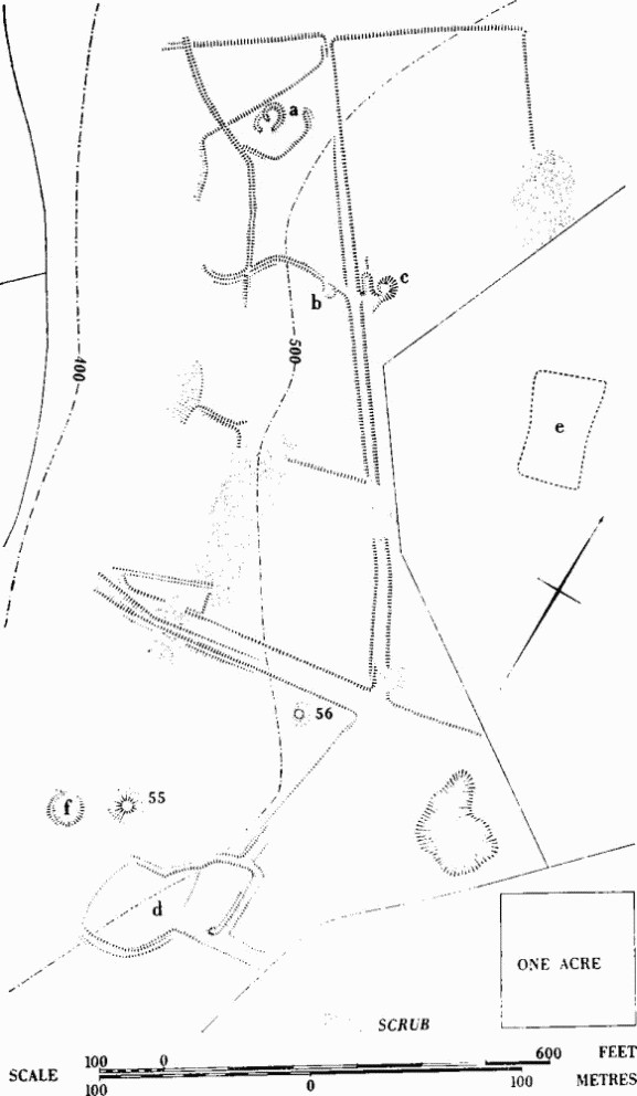
(64) Settlement, probably prehistoric (SY 68 NW; 61538937–61668904), lay in Ancient Field Group (3) (Fig. opp. p. 624) and covered 8 acres of former downland called 'Rowden', which divided two blocks of open fields (Winterbourne Steepleton (12), p. 396); it was examined before destruction in 1962. The features were not necessarily contemporary but all except (e) appeared to be linked by tracks. They lay at around 500 ft. above O.D. facing W. on the brow above a dry valley in the chalk. (R.A.F. V.A.P. CPE/UK 1934: 3095–6.)

Winterbourne Steepleton (64)
From the N. the complex comprised: (a) a hut-circle 14 ft. across within an incomplete angular enclosure of 1/6 acre, itself apparently set within an irregular enclosure of 1½ acres; (b) 80 yds. S.E., a circular hut-platform 20 ft. across set against the E. end of the S. bank of the last-named enclosure; (c) a hut-platform 15 ft. across, to the N.E. of (b); (d) 300 yds. further S., an angular enclosure of 3/5 acre; and (e) 100 yds. E. of (c), the soil-mark of an irregular oblong enclosure, long ploughed flat, about 2/5 acre in area. A large circular platform (f), with almost flat floor 36 ft. across levelled into the slope, was more likely to be a hut-circle and part of the settlement than a pond barrow.
A terrace-way 10 ft. to 15 ft. wide ran from due E. of (a) S.E. for about 280 yds. to a disturbed junction of tracks. A broad slightly sunken way 45 ft. wide ran downhill W. from this junction, its lower end hollowed on the S. side by later usage. Traces of a track ran S. from the junction towards (d), from which a track extended N. to meet it. This last led round the E. side of (d) to an entrance where it was met by a further track from the E.
Slight lynchets and banks within the area indicated cultivation but there were no certain contacts with 'Celtic' fields. The nature of the remains and the existence of at least six barrows around (d) suggest that this area never bore 'Celtic' fields and was reserved early for settlement.
For further possible settlement areas see Ancient Field Group (3).
FINDS INDICATING SETTLEMENT
At the sites listed below there are no earthworks but finds indicating probable prehistoric settlement have been made. For other sites where finds indicate probable continuity into the Roman period, see the Roman section, pp. 520–621. Within each parish the sites are listed in order of probable date. Unless otherwise stated, references are to Proceedings of the Dorset Natural History and Archaeological Society.