An Inventory of the Historical Monuments in Dorset, Volume 2, South east. Originally published by Her Majesty's Stationery Office, London, 1970.
This free content was digitised by double rekeying. All rights reserved.
'Winterbourne Steepleton', in An Inventory of the Historical Monuments in Dorset, Volume 2, South east(London, 1970), British History Online https://prod.british-history.ac.uk/rchme/dorset/vol2/pp394-397 [accessed 17 April 2025].
'Winterbourne Steepleton', in An Inventory of the Historical Monuments in Dorset, Volume 2, South east(London, 1970), British History Online, accessed April 17, 2025, https://prod.british-history.ac.uk/rchme/dorset/vol2/pp394-397.
"Winterbourne Steepleton". An Inventory of the Historical Monuments in Dorset, Volume 2, South east. (London, 1970), British History Online. Web. 17 April 2025. https://prod.british-history.ac.uk/rchme/dorset/vol2/pp394-397.
In this section
50 WINTERBOURNE STEEPLETON (6489)
(O.S. 6 ins. aSY 68 NW, bSY 69 SW)
Winterbourne Steepleton, a rectangular parish of some 1,800 acres, lies across the valley of the South Winterborne 4 miles W. of Dorchester. It is entirely on Chalk, with extensive areas of later gravel deposits especially on the higher S. parts. From the S. boundary on the crest of the S. Dorset Ridgeway, up to 776 ft. high, the ground slopes down to the Winterborne at just under 300 ft. broken by deeply cut dry valleys formerly draining N. Beyond the river the land rises to the N. boundary at just over 400 ft. above O.D.
Winterbourne Steepleton, beside the river, is the original and still the only settlement in the parish and contains a few houses of the 16th and 17th centuries. The parish has 49 round barrows and a large area of 'Celtic' fields; there are also extensive remains of the open fields which were not finally enclosed until the 19th century.
The parish church, with a Saxon carving of an angel, is the principal monument.
Ecclesiastical
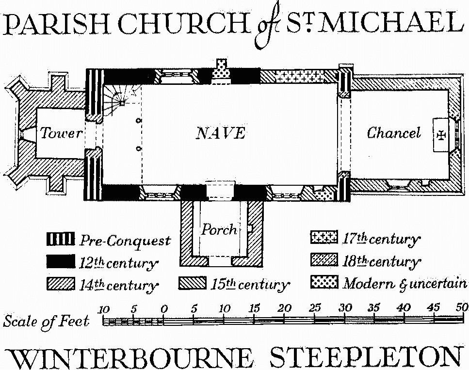
a(1) The Parish Church of St. Michael stands at the E. end of the village. The walls are mostly of Portland rubble with some Ham Hill dressings; the roofs are slate-covered. There was a church here in the first half of the 11th century of which the quoins at three corners of the nave survive. The Nave was rebuilt in the 12th century. The West Tower (Plate 3) and the South Porch were added in the 14th century. The Chancel was rebuilt in the 15th century. A 15th-century N. chapel was demolished in 1688 (Hutchins II, 776) and on the site is the late 18th-century Lambert vault. The church was restored in 1902.
The church is of importance for the retention of the three quoins of a pre-Conquest nave and the contemporary carved angel, formerly part of the rood, reset in the S. wall of the nave. A comparable angel survives in situ at Bradford on Avon.

Parish Church of St. Michael, Winterbourne Steepleton
Architectural Description—The Chancel (16½ ft. by 15 ft.) has a modern E. window. In the S. wall is a 15th-century window of two cinque-foiled lights with vertical tracery in a two-centred head with a label. The chancel arch, rebuilt in the 18th century, is three-centred and of two chamfered orders, the inner dying on to the responds.
The Nave (39 ft. by 16½ ft.) has at the S.E., N.W., and S.W. corners pre-Conquest quoins of large stones, alternately tall and short in places. In the N. wall is a 15th-century two-centred archway to the former N. chapel, blocked in the 17th century; midway along the same wall is a blocked 12th-century N. doorway with roll-moulded semicircular head, plain tympanum and jambs and with a buttress built against the blocking; further W. is a 15th-century window of three cinque-foiled lights with vertical tracery in a two-centred head with moulded reveals. In the S. wall at the E. end is a blocked 15th-century doorway with a four-centred head, to the former rood stair; the 12th-century S. doorway is immediately opposite the N. doorway and of similar design, but not blocked; it is flanked to E. and W. by two 15th-century windows of three lights generally similar to that in the N. wall but with labels with head-stops; high in the wall at the W. end is an early 18th-century window of two lights for the west gallery. In the W. wall is a 14th-century doorway to the tower with chamfered jambs and two-centred arched head; above it is a 12th-century window of one pointed light with a label, now opening into the tower.
The West Tower (8 ft. square) of the late 14th century is of three stages, divided by weathered strings and with two-stage diagonal buttresses to the W. and similar buttresses in the centre of the N. and S. walls. It is surmounted by a plain parapet and a later octagonal stone spire with corner pinnacles, probably of the 18th century. The W. window is of one trefoiled light with sunk spandrels in a square head. The bell-chamber has, in each of the N., S., and W. walls, a window of two trefoiled lights in a square head with a label and headstops.
The South Porch (9 ft. square) has a 14th-century outer entrance with chamfered jambs and a two-centred head under a label.
Fittings—Altar: in chancel, reset upon communion table, stone slab (originally 4½ ft. by 2½ ft.) with five consecration crosses, 12th or 13th-century. Bells: one, inscribed SS maria SS, late mediaeval. Brass: in chancel—on N. wall, to Daniel Sagittary, M.A., rector, 1756, brass plate with crest and inscription. Door: in S. doorway, nail-studded with strap hinges, 17th or early 18th-century. Font: circular Bath stone bowl with cable ornament at top, moulded arcade of segmental arches below, springing, alternately, from shafted pilasters and corbels, late 12th-century; stem of Purbeck marble, cylindrical with four attached shafts and moulded base on square plinth, 13th-century. Gallery: at W. end of nave—front panelled with range of balusters above, bearer inscribed 1708 G.C.8, supported on round timber posts. Glass: in N. and S. nave windows, in tracery lights, with stars, crowns, sacred monogram and leopard's face, 15th-century. Monuments and Floor-slabs. Monuments: in churchyard W. of tower, seven table-tombs of the 17th and 18th centuries including (1) to Richard Meech, 1659, and Richard Meech the 'yonger', 1703, (2) to Edward Hodder, 1690, and others, erected by John Tasker, 1701. Floor-slabs: in chancel, (1) to Elizabe[th], wife of Gillb[ert] Ironside, 1643; in nave, (2) to Eleanora Banger, 1797, and others.
Paintings: in nave—on N. wall, traces of Stuart royal arms and of 15th-century figure of St. Christopher, with 17th-century Lord's Prayer below; on S. wall, 13th-century painted masonry lines with 15th-century vine-scroll design; all now painted over. Plate: includes cup and cover-paten of 1571, stand-paten of 1709 the gift of Sarah Clapcot, and a pewter flagon dated 1719. Pulpit: modern but incorporating three arcaded and enriched panels, with figures at angles, 17th-century. Scratch Dial: on S.W. quoin of nave. Sculpture (Plate 196): built into outside face of S. wall of nave at W. end, stone (25 ins. by 15 ins.) carved in high relief with figure of angel flying with face turned backwards and feet turned upwards, first half of 11th century. Miscellanea: in churchyard, near porch, loose stone with socket for former cross, mediaeval.
Secular
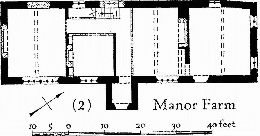
a(2) Manor Farm, house (200 yds. W.), is of two storeys and has walls of alternate bands of flint and freestone; the roof is covered with modern slates but with the lower courses of local stone slates. The house was built in the late 16th or early 17th century and was originally only one storey high at the N. end; it was later heightened to two storeys throughout. The porch on the E. front is of stone without flint banding and may be an early addition. The house now stands with its back to the road, but it seems probable that the road originally ran to the S. of the house, through the present farmyard.

Manor Farm
The two-storey porch has an outer doorway with chamfered and cambered stone head and continuous jambs; the windows are mostly original, with stone mullions and, on the ground floor, moulded labels. The back of the house has a weathered string-course along the centre part which was probably put in to protect the roof of a lean-to which has since been removed; it crosses an 18th-century staircase window, dividing the three bottom lights from a semicircular top light; a ground-floor window below the string is modern. The house originally comprised, on the ground floor, two heated rooms with an unheated room between them, and an unheated service room at the N. end. The entrance may have led directly into the N. heated room. In the S. room the fireplace has been rebuilt; the middle of the house has been rearranged to provide an office or study with a fireplace built in the 19th century, and the present staircase is of the 19th century. The fireplace in the room to the N. has been rebuilt but retains the original moulded four-centred stone head and continuous jambs, all reset.
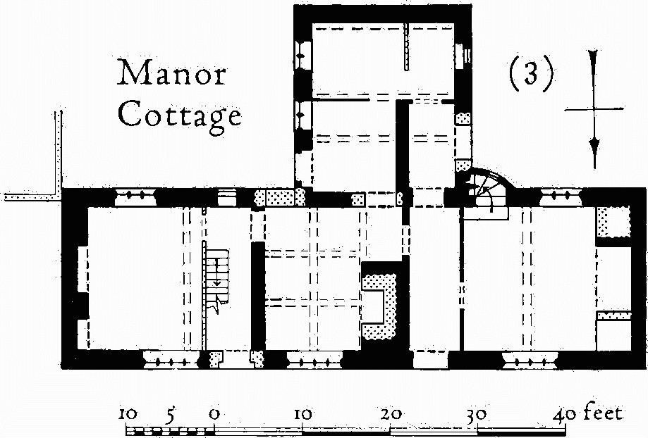
a(3) Manor Cottage (100 yds. W.) has walls of coursed rubble and thatched roof; it was built in the late 16th century with one storey and attic, and was later heightened to two full storeys.
The plan has a main range of three rooms with a through passage and a staircase in a small curved projection against the back wing. The windows have hollow-chamfered stone frames and mullions, and some have labels. The central room, with its chimney backing onto the passage, has the ceiling divided into panels by intersecting beams. The E. room has been reduced in size by the insertion of a new entrance doorway, hall and staircase.

Manor Cottage
a(4) Riverside Cottage (350 yds. W.), with walls of banded flint and stone and thatched roof, was built in the 17th century as one storey and attic and later heightened to two full storeys. On plan it comprises two rooms with end chimneys and a central passageway now replaced by a staircase.
a(5) Champs Cottage, 10 yds. W. of (4), of two storeys with walls of squared rubble and thatched roof, is of the early 18th century. On plan it comprises two rooms; the larger room has fireplace and entrance in the gable end and is separated from the smaller room by a moulded muntin and plank partition.
b(6) Cottages (621903) are of the 19th century but include a gable wall of banded flint and stone, probably of the 17th century.
a(7)House, The Thatchery (170 yds. W.), has rubble walls banded in the lower parts with flint, and thatched roof. The house is of the 18th century, but the flint banding may indicate that the lower parts of the walls are earlier.
a(8) Mill and Millhouse (90 yds. N.W.). The house, of two storeys with stone rubble walls and slated roof, is of the 17th century but has been partly rebuilt in brick and has a wing added in the 18th century. On plan the original part comprises one room with a chimney at one end and a small room off it at the other end now divided for a staircase. The watermill adjoining the house was rebuilt in brick in the late 18th century.
a(9) Cottages, three (60 yds. N.W.), are of the first half of the 19th century but include some banded flint and rubble walling of the late 16th or early 17th century.
a(10) Blagdon Barn (619883), of brick and stone, roofed with modern sheeting, is of the early 19th century.
Earthworks, Etc.
Mediaeval and Later Earthworks
a,b(11) Settlement Remains, formerly part of Winterbourne Steepleton village (624901, 630897, 631898; Fig. in pocket), cover about 10 acres.
The remains at the W. end of the village, covering 3 acres, are very disturbed but continue N.W. the line of existing closes S. of the main street. E. of the Manor House disturbed banks 2 ft. to 3 ft. high once formed five or more enclosures but now only remain as a series of bays, 60 ft. to 120 ft. wide, running N. from a scarp 5 ft. to 7 ft. high continued E. by a boundary line. The name 'Droveway' on the Tithe Map for an enclosure to the E. of these bays supports the suggestion of other boundaries on the map that a road continued the line of the village street eastwards, below these closes and S. of the present road. N.E. of the church two large enclosures on a S.-facing slope of about 10° are formed by banks 19 ft. across and 4 ft. high with ditches 10 ft. wide; these banks continue E. and W., suggesting further incomplete enclosures. In 1840 these closes lay in Cowleaze and were partly indicated on the Tithe Map which also suggests that they were cut by the existing road. (R.A.F. V.A.P. CPE/UK 1934: 5093.)
a,b(12) Strip Fields (Fig. in pocket; Plate 207) occur on Chalk to the W., S.E. and N. of the village, covering about 37 acres now mostly used as pasture. All the surviving strip lynchets are of contour type. Treads vary from 2 yds. to 60 yds. wide and risers from 1½ ft. to 14 ft. in height. Natural slopes are from 3° to 15°. Other slight remains and traces on air photographs show, with the aid of the Tithe Map of 1840, that a much greater extent of the parish, up to 375 acres, was once cultivated in strips. These traces are seen on Greensand and Bagshot Beds as well as on the Chalk. They indicate also the former existence of up-anddown strip lynchets and broad ridge-and-furrow.
The Tithe Map shows three large open fields: West (75 acres), Middle (95 acres) and East Fields (84 acres) and Loscombe, a smaller open field to the S.W. of Middle Field, separated from it by downland called Rowden. Most of the surviving remains can be fitted into the pattern of named furlongs making up these fields, but other strip lynchets outside their limits as well as angular recesses in modern boundaries, formerly marking the ends of strips, suggest that the open field system was once larger. It extended S. and E. of East Field, S. of Middle Field and N. of the village in the area known in 1840 as North Down. Traces of strip cultivation also cut through 'Celtic' fields on Cowleaze, S. of Loscombe (see Ancient Field Group (3)).
Comparison between the map and the remains illuminates field structure and arrangement. Shading on the Tithe Map indicates substantial risers to the strip lynchets in Crabtree, Benneck and Walls furlongs (in Middle field; group (b) below). On the ground unploughed wedges, or 'gores', between these risers at the S. end of Walls furlong show that the terraces were built up by long plough action (see profile). The uphill treads here have a downward cross slope of 7°, but those lower down, on a similar natural slope, are virtually flat. Turning arrangements for the plough at the end of each of these furlongs (where the map seems to show a series of butt junctions) depended on a system of interlocking ramps. On the W. of the Portesham road some contour strip lynchets seem to have ended against headlands at right angles to the slope.
Several furlong names apparently refer to antiquities which have disappeared, for example 'Catsbarrow' and 'Lot Barrow'. 'Brass Stone' probably refers to the stones described below under Monument (65). 'Broadlands' might well refer to broad ridge-and-furrow and perhaps recalls a name in use in the early 16th century (Hutchins II, 775). (R.A.F. V.A.P. CPE/UK 1934: 3092–6 and 5092–5.)
(a) Three strip lynchets (615889) overlie 'Celtic' fields; in 1840 they were part of Loscombe field but are now in a wood.
(b) A series of strip lynchets (615896–621901) covering 28 acres extends for ½ mile on the E. side of the Portesham road valley (Plate 207), corresponding from S. to N. with Crabtree, Benneck, Walls, Taskers Bar and White Horse furlongs in Middle Field, arable in 1840. Treads vary in width from 2 yds. to 60 yds. Narrow rig still to be seen on the upper treads of the two N. furlongs is presumably datable to 1840 or later.
(c) Three strip lynchets (618902) lie N.W. of the Portesham road. In 1840 they were part of Twelve Acre Furlong in West Field. These seem to be the strips noted in 1903 but described as near Winterbourne Abbas (C. March, Dorset Procs. XXIV (1903), 83–4).
(d) Two strip lynchets (627900) face S. on North Hill, part of North Down, pasture in 1840. Their W. ends have been cut into and crossed by narrow rig, which also lies below them. A sunken track cutting diagonally across them is shown on the Tithe Map.
(e) Remains of at least four strip lynchets (631895) lie on a N. slope immediately S.E. of some of the village remains (11). In 1840 they were in Carry Hill pasture.
Other Earthworks and Allied Monuments
(13) Long Barrow, p. 433
(14–62) Round Barrows, p. 471
(63) Enclosure, p. 508
(64) Settlement, p. 510
(65) Stones, p. 515
(66) Linear Dyke, p. 519
Ancient Field Group (3), p. 624