An Inventory of the Historical Monuments in Dorset, Volume 1, West. Originally published by Her Majesty's Stationery Office, London, 1952.
This free content was digitised by double rekeying. All rights reserved.
'Minterne Magna', in An Inventory of the Historical Monuments in Dorset, Volume 1, West(London, 1952), British History Online https://prod.british-history.ac.uk/rchme/dorset/vol1/pp167-170 [accessed 17 April 2025].
'Minterne Magna', in An Inventory of the Historical Monuments in Dorset, Volume 1, West(London, 1952), British History Online, accessed April 17, 2025, https://prod.british-history.ac.uk/rchme/dorset/vol1/pp167-170.
"Minterne Magna". An Inventory of the Historical Monuments in Dorset, Volume 1, West. (London, 1952), British History Online. Web. 17 April 2025. https://prod.british-history.ac.uk/rchme/dorset/vol1/pp167-170.
In this section
67 MINTERNE MAGNA (E.c.)
(O.S. 6 in. (a)XXII, N.W. (b)XXII, N.E. (c)XXII, S.W.)
Minterne Magna is a parish 8 m. S. of Sherborne. The camp on Dungeon Hill is the principal monument. Minterne House has been entirely rebuilt but contains a series of Brussels tapestries of domestic scenes, woven by de Vos after designs by Teniers, and given to General Charles Churchill.
Ecclesiastical
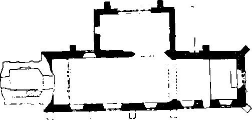
c(1) Parish Church of St. Andrew stands in the S. part of the parish. The walls are of local rubble and flint with dressings and ashlar of Ham Hill stone; the roofs are covered with tiles and stone slates. The Chancel and Nave were built in the first half of the 15th century. The North Chapel was added about 1610–20, perhaps on the site of an earlier chapel. The West Tower was rebuilt in 1800 and there was a general restoration in 1894 when the tower was heightened.
Architectural Description—The Chancel (19¾ ft. by 13½ ft.) has a partly restored 15th-century E. window of three trefoiled lights with vertical tracery in a two-centred head; the gable has been rebuilt. In the N. wall is a 15th-century window of two trefoiled lights with plain tracery in a square head; it is blocked by the organ. In the S. wall are two windows the western modern and the eastern similar to the N. window but with cusped tracery; the 15th-century doorway has chamfered jambs and a two-centred head. The 15th-century chancel-arch is two-centred and moulded; the much restored responds are continuous.

The Church, Plan
The Nave (37½ ft. by 15¼ ft) has, in the N. wall, a 17th-century round arch with continuous mouldings carried down to plain plinths; further W. is an early 15th-century window of two trefoiled lights with a quatrefoil in a two-centred head. In the S. wall are three windows, the middle one modern and the other two of the 15th century and of two cinque-foiled lights with vertical tracery in a two-centred head and modern labels.
The North Chapel (22½ ft. by 12¼ ft.) is ashlar-faced, of early 17th-century date, and has a later 17th-century building with a pent roof against the E. wall; it is a vault of the Napier family. In the N. wall of the chapel is a window of five four-centred lights, the middle light higher than the rest and all with moulded reveals and label; the wall is finished with a coved cornice. In the W. wall is a doorway with chamfered jamb's and four-centred head; above it is a window of four four-centred lights with a moulded label.
Fittings—Bells: two, late mediæval; 1st inscribed "Sancta Maria ora pro nobis"; 2nd inscribed "Sancta Elisabet ora pro nobis". Brasses: In N. chapel—on the walls, six square plates engraved with shields-of-arms showing Napier alliances, with the Napier names below: on N. wall, (a) Napier impaling Alington, (b) Napier; on S. wall, (c) Napier impaling Denton, (d) Napier impaling Gerard; on W. wall, (e) Napier impaling Lucy, (f) Napier impaling Colles, 19th-century. In nave—on S. wall, to Sir Henry Digby, G.C.B., Admiral of the Blue, 1842, and later inscription below, signed Waller, London, with his mark. Consecration Crosses: six, two on E. wall of chancel, one on N. wall of chancel, one on N. wall of nave and one (possibly two) on S. wall of nave, all in low relief with expanded ends, 15th-century. Font: octagonal bowl with quatrefoil enclosing flower or lozenge in each face, moulded necking, plain stem, 15th-century, base modern. Glass: In nave—in N. window, part of shield of France and England quarterly and foliage, 15th-century. Monuments and Floor-slabs. Monuments: In nave—on N. wall, (1) to General Charles Churchill, 1714, erected by his widow Mary (Gould), white and veined marble wall-monument (Plate 150) with Composite side-pilasters, entablature, achievement-of-arms, cherub-heads and trophies of arms. In N. chapel— against E. wall, (2) to Sir Nathaniel Napier, Bart., 1708–9, and Jane (Worsley), 1692, and Catherine (Alington), 1724, wives of his son Sir Nathaniel Napier, Bart., and two sons and two daughters of the second wife, wall-monument erected by the son, Sir Nathaniel Napier, Bart., and signed Robert Taylor, white and veined marble monument (Plate 151) with Corinthian side-columns, entablatures, continuous cornice, broken pediment, cartouche-of-arms, putti and allegorical female figures; on N. wall, (3) to Mary (Herbert) wife successively of Sir Robert Worsley and Edward, Earl of Ganesborough, 1693, white marble tablet (Plate 21) with scrolls, cornice, pediment and achievement-of-arms; (4) to Sir Robert Napier, Chief Baron of the Exchequer in Ireland, 1615, Magdalen, his wife, 1624–5, Sir Nathaniel Napier, 1635, Elizabeth (Gerard), his wife, 1624, Sir Gerard Napier, Bart., 1672, Margaret (Colles), his wife, 1660, Sir Nathaniel Napier, Bart., who erected the monument, Blanch (Wyndham), his wife, [1695], and Wyndham, Robert, Margaret, Blanch, and Blanch Katerina, their children, white marble scrolled cartouche (Plate 20) with flowers, cherub-heads and cartouche-of-arms; on S. wall, (5) to Blanch (Wyndham), wife of Sir Nathaniel Napier, 1695, white marble tablet with drapery, urn and cartouche-of-arms, tablet on panelled stone pedestal. Floor-slabs: In nave—(1) to John Churchill, 1659, with shield-of-arms; (2) to William . . ., 1684, and Elizabeth, his wife, 1683; under lectern, (3) to Ellen, daughter of Winston Churchill, 1673. Piscina: In nave—in S. wall, recess with pointed head, 15th-century, sinking in sill but no drain. Seating: In tower —two coffin-stools with turned legs, 17th-century. Miscellanea: In S. wall of chancel—reset head-stop, 13th or 14th-century.
Secular
Monuments (2–5)
The following monuments, unless otherwise described, are of the 17th century and of two storeys; the walls are of rubble and the roofs are covered with thatch or modern materials. Some of the buildings have exposed ceiling-beams.
c(2) Manor Farm, house 60 yards W.N.W. of the church, has been much altered.
a(3) Bridle's Farm, house on the S.W. side of the road, 2 m. N.N.E. of the church, retains some original stone windows and one room has moulded ceiling-beams.

Dungeon Hill Camp
a(4) Lower Grange Farm, house ¼ m. N.W. of (3), has been rebuilt but incorporates some original stone windows.
a(5) Hartley Cottage, on the edge of the parish, over 1½ m. N.W. of the church, retains an original two-light stone window and a doorway with a four-centred head.
Earthworks
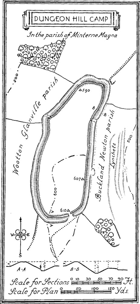
b(6) Dungeon Hill Fort occupies the summit of Dungeon Hill (610 ft.) in a nearly isolated end of the parish, 2¾ m. N.E. of the church. The work consists of an irregular oval enclosure (internal area 9 acres) with a single rampart and ditch; there are slight traces of an outer bank on most of the E. side. The rampart rises 8 ft. above the internal area and a maximum of 21 ft. above the bottom of the ditch. There is an entrance at the S. end but the rampart at this point appears to have been partly destroyed perhaps to widen the causeway across the ditch. There are modern entrances towards the N. end on both sides; that to the W. is cut through a projecting part of the defences.

Earthwork in Dogbury Plantation, in the parish of Minterne Magna
c(7) Earthwork in Dogbury Plantation, ½ m. N. of the church, occupies the top of a ridge (800 ft.) and consists of about 130 yards of bank running N.E. and having remains of a rounded angle at the S.W. end. There is a slight inward curve also at the N. end. The rampart rises about 3 ft. above the ground-level to the N. and about 7½ ft. above the bottom of the ditch on its S.E. side. The work has been cut through by a roadway but to the N.E. of this is a gap and causeway which seems to have been an original entrance. The general form of the work, with the existence of a rough scarp to the S. of the roadway, might suggest an enclosure or small hill-fort, perhaps never completed, but in its present condition is more suggestive of a cross-dyke.
c(8) Mound, probably the remains of a barrow, to the S. of the road, 1,050 yards N.W. of the church, is about 34 ft. in diam. and 2¾ ft. high. There is a circular sinking in the middle.
c(9) Mound, probably a barrow, on Farm Hill, 1,070 yards S. of the church, is 51 ft. in diam. and 1½ ft. high. It has been disturbed in the middle.
c(10) Lynchets, on the S.W. slope of Dogbury Hill, ¼ m. N. of the church, form two systems in adjoining fields.