An Inventory of the Historical Monuments in the County of Cambridgeshire, Volume 1, West Cambridgshire. Originally published by Her Majesty's Stationery Office, London, 1968.
This free content was digitised by double rekeying. All rights reserved.
'Eltisley', in An Inventory of the Historical Monuments in the County of Cambridgeshire, Volume 1, West Cambridgshire(London, 1968), British History Online https://prod.british-history.ac.uk/rchme/cambs/vol1/pp89-98 [accessed 17 April 2025].
'Eltisley', in An Inventory of the Historical Monuments in the County of Cambridgeshire, Volume 1, West Cambridgshire(London, 1968), British History Online, accessed April 17, 2025, https://prod.british-history.ac.uk/rchme/cambs/vol1/pp89-98.
"Eltisley". An Inventory of the Historical Monuments in the County of Cambridgeshire, Volume 1, West Cambridgshire. (London, 1968), British History Online. Web. 17 April 2025. https://prod.british-history.ac.uk/rchme/cambs/vol1/pp89-98.
In this section
16 ELTISLEY
(O.S. 6 ins. aTL 26 S.E., bTL 25 N.E.)
Eltisley occupies a complex of watersheds dividing streams which flow S.E. to the Bourn Brook, W. to the upper Ouse at St. Neots, and N. to the lower Ouse at St. Ives. The land, which extends to 1970 acres, is nowhere lower than 150 ft. and is entirely boulder clay.
Most of Eltisley's few houses are grouped around a triangular green at the junction of the ridgeway, now the high road from Cambridge to St. Neots, with a N. to S. track from Biggleswade to St. Ives; in addition a lane to Cambridge along the valley of the Bourn Brook through Caxton leaves the green at its S. apex. Occupation extends S. of the green along the Biggleswade road and along the Cambridge lane where there was a second green at Caxton End; two of the five moated sites in the parish, Monuments (19) and (24), lie between them. A third moated site, Monument (22), is in the N.W. of the parish.
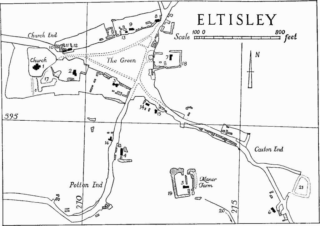
Eltisley
Eltisley is said to have been the site of a Saxon nunnery in which Pandionia, daughter of a Scottish king, took refuge (Nicholas Roscarrock, c. 1549–1634, 'Lives of English Saints,' C.U.L. Add. MS. 3041, f. 343–4). Her name is preserved in the dedication of the church. The site of the nunnery, if it ever existed, is unknown, but the community is believed to have transferred to Hinchingbrooke after the Conquest (R.C.H.M., Hunts., 152). Leland (De Scriptoribus, ed. Hall(1709), 359) mentions a life of Pandionia by Richard, parish priest of Eltisley, and also asserts (Itinerary, ed. L. T. Smith, V (1910), 218) that this same Richard in 1344 translated her body into the church from the vicinity of the well in the churchyard called after her.
The village seems to have been something of a centre of religious reform and dissent. The Disbrowe family were probably already settled here in the 16th century (Mark Noble, Memoirs of the Protectoral House of Cromwell (1787), 274) and became lords of the manor and patrons of the living. James Disbrowe, d. 1638, who with his wife Elizabeth built Monument (2), was the father of John who married Oliver Cromwell's sister Jane, and of Samuel, Keeper of the Great Seal of Scotland under the Commonwealth (see Elsworth, Introduction and Monument (3)); James the younger a third son, is said to have been a fanatical puritan.
During the 18th century the Leeds family of Croxton extended their estate into Eltisley; the livings are now occupied by one incumbent who lives on the boundary. The parish was enclosed by act of 1864, with award in 1868; the population has declined during the last hundred years and there has been little building activity.
Ecclesiastical
b(1) Parish Church of St. Pandionia and St. John Baptist stands at the W. corner of the village green and consists of Chancel, Nave with Aisles and North Chapel, and West Tower. The churchyard, extended in recent years to the N. and E., was originally bounded at least on those sides by a ditch still surviving as a depression. It was probably fed by St. Pandionia's Well, described by Leland (Itinerary, ed. L. T. Smith, I (1907), I) as being 'yn the South side of the Quire'. The well mentioned by Leland is no doubt the same as that in the churchyard, the stonework of which was demolished by Robert Palmer, vicar, some time prior to his presentation before the consistory court in 1576–'it was a well used for superstitious purposes, therefore he brake it down' (C.A.S. 8vo. Publs. LIII (1935), 84). The walls of the fabric are of field stones with limestone and clunch dressings, save for the chancel and part of the N. transept which are of white brick; the roofs are covered with lead, slates and asbestos sheeting.
The nave and aisles were built c. 1200. The N. chapel was added and the chancel rebuilt or extended in the 13th century. The clearstorey was remodelled and the tower added in the later middle ages. The chancel and much of the N. chapel were rebuilt in white brick c. 1840, and there was a general restoration in 1875–9.
Architectural Description—The Chancel is of the mid 19th century but incorporates a 13th-century S. doorway with plain chamfered jambs, imposts and head. The 13th-century chancel arch is of two chamfered orders and has moulded labels with mask stops; its responds are stop-chamfered and have attached half-round shafts with moulded caps and bases.
The Nave (39¾ ft. by 17¾ ft.) has similar but not completely uniform N. and S. arcades, both more or less restored, and each divided into three bays by circular piers with carved capitals (Plate 12) and chamfered or moulded bases. The arches are two-centred and of a single chamfered order with chamfered labels on both sides which have a linking horizontal return above the piers; above this return on the S. side of the first pier of the S. arcade and on both sides of the second pier carved features resembling stops survive. The responds of the S. arcade are half piers, but with plain caps; on the N. side the later mediaeval part-octagonal E. respond supports and largely obscures a deep moulded corbel from which the first arch seems originally to have sprung, while the W. respond is modern. The capitals are carved with 'stiff leaf' or 'water leaf': on the N. side that of the first pier is modern and that of the second has been mutilated and partially made good in plaster; on the S. side both have been more or less re-tooled. The E. responds of the nave are comparatively deep and have on their nave sides rectangular projections rising to the level of the caps which presumably represent the original chancel arch, adapted in the 13th century as the base of a pulpitum or screen. This last was reached by a straight flight of steps commencing in the N. aisle with a two-centred door at the foot and a trefoil-headed door at the head. The clearstorey is lit by modern two-light windows of late mediaeval character, three to the S. and two to the N., the first bay on that side being blind on account of the abutting roof of the chapel.
The North Aisle (6½ ft. wide), of which the W. half only survives, is of c. 1200 in origin. Its window is modern, but the N. doorway with continuously chamfered jambs and head is original.
The South Aisle (5¾ ft. wide) is also of c. 1200 in origin but has been rebuilt at various times and all its windows, which are of late mediaeval character, are modern. The S. doorway is of c. 1200; its head is of a single chamfered order carved with 'dog tooth' supported by nook-shafts in the jambs with moulded caps and bases; the E. cap is enriched with 'water leaf'. The S. porch is modern.
The North Chapel (20½ ft. by 18 ft.), added in the 13th century, incorporated the E. half of the aisle. Its W. wall, which has been largely rebuilt, is carried over the aisle on a round arch. The W. portion of the N. wall has also been rebuilt but E. of its modern window the splay and part of the sill of an earlier window are visible. The E. wall is 13th-century and has a restored original window of three lancets, with individual external labels, grouped internally under a moulded depressed rear arch which rises off shafted jambs and has a moulded label; the arch and the caps of the jamb shafts are enriched with 'nail-head'.
The late mediaeval West Tower (10¾ ft. square) is of three architectural stages crowned by an octagonal stone spire. It has diagonal buttresses to the W., a vice in the N.W. angle with canted projection carried on a small arch, and an embattled parapet. The windows are heavily restored or modern. The tower arch, of two moulded orders on the E. and three chamfered orders, the outermost dying against the side walls, on the W., has attached part-circular shafts to the responds with moulded caps and bases. The spire has an upper single-light and lower two-light window in each cardinal face beneath cusped and crocketed gablets.
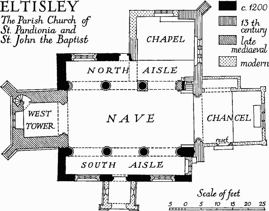
Eltisley, the Parish Church of St. Pandionia and St. John the Baptist
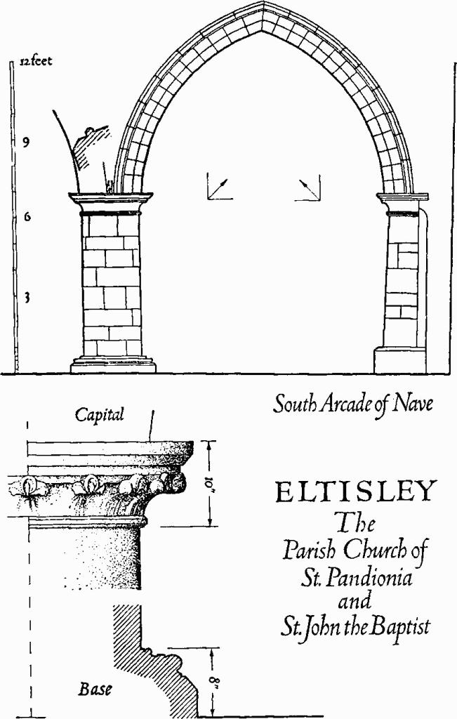
Eltisley, the Parish Church of St. Pandionia and St. John the Baptist
Fittings— Bells: four; 1st by Joseph Eayre of St. Neots, 1766; 2nd with incomplete alphabet in Lombardic capitals and a founder's mark of a shield charged with three bells, attributed to the Brasyer family, 16th-century; 3rd with initial cross, black-letter inscription, 'Sit Nomen Domini Benedictum' and a founder's mark of a shield with arms possibly of Kebyll, late 15th-century; 4th with a rhyming inscription, by Newcombe of Leicester, 1608. Bracket: at E. end of S. aisle, moulded shelf rising off lion-mask corbel, defaced, some traces of old priming or colour; 14th- or 15th-century. Brass: in N. chapel, of Matthew Marshall, 1640; inscription plate and shield of arms. Clock: in tower, where it was placed in 1893; formerly in the tower of the parish church of Chertsey, Surrey; perhaps 18th-century. Communion table: with turned legs and fluted top rail; 17th-century. Font: plain octagonal bowl with chamfered lower edge, 13th-century, on re-tooled clunch stem; pyramidal cover of eight sides carved in low relief with thistles and other conventional flowers and with moulded base and finial, 17th-century. Monuments and Floor slabs. Monuments: In N. chapel—in E. half of N. wall (1) tomb recess, one of two described by Cole, under moulded depressed arch, its moulded and crocketed label rising to a finial and having a W. stop carved with a lion's head and a woman's head. Above and E. of the arch are remains of an outer frame, consisting of a rectangular panelled shaft with embattled cap and a length of moulded and embattled cornice. Beneath the arch on uniform tapered slabs with hollow-chamfered edges are the mutilated figures of a robed female figure and of a knight in chain mail and surcoat with blank shield on left arm and left hand on sword pommel. The effigies appear to be mid 13th-century, while the recess is of the second half of the 14th century; according to Layer (Palmer, Inscriptions and Arms from Cambs., 225) they were decapitated by Robert Palmer, vicar in the reign of Elizabeth I. Some of the loose fragments lying in the recess are from the knight's effigy. On N. wall (2) of John Baron, 1827, wall monument by Northern. In nave—on W. wall (3) of Mary Webb, 1831, wall monument. In S. aisle—on S. wall (4) of Ann Baron, 1833, wall monument by Sidney. S. of the church are a number of 18th-century headstones. Floor slabs: In N. chapel—(1) of Joseph Barringer, 1755; (2) of Mary Barker, 1792; (3) of Thomas Owens, 1829. Plate: includes a cup, London 1564.
Secular
b(2) House (Plate 77), an L-shaped framed building of two storeys and attics with tiled roofs, comprises a N. and S. range with a cross wing at the S. end projecting to the W. and a staircase in the re-entrant. Attached to the S. end is an outhouse used as a kitchen, formerly of a single storey open to the roof; it is either original or an early addition. The lintel of a blocked front door (Plate 37) in the W. face of the staircase is carved with the initials and date 'ID 1612 ED': the house was presumably built in that year for James Disbrowe and his wife Elizabeth (Marshall); the Disbrowe family had already been settled in Eltisley for two generations. Monument (17) below may be the remains of a garden connected with this house.
Except for the outhouse, which is plastered, the framing is mostly exposed externally; it consists of pronounced vertical studwork with horizontals at the floor levels; braces are internal (their position being traceable outside by the pegging) and the only decorative relief is a small lozenge centrally placed in the W. gable of the staircase projection. Most of the doors and windows are modern but they are generally replacements of original features. There are a number of modern repairs and both chimneys have been at least partly reconstructed.
The N. end of the range has a projecting central oriel, completely restored, rising to the full height of the building. The E. elevation comprises the long side of the main structure with the jettied gable of the cross wing at its S. end rising off a bressummer supported on three brackets; a window in the gable retains an old iron casement. Above the modern front door is an original window divided by a central stud and sub-divided into six lights by ovolo-moulded mullions. The W. elevation has an external brick chimney at the N. end; S. of it is the staircase projection and the gabled end of the cross wing.
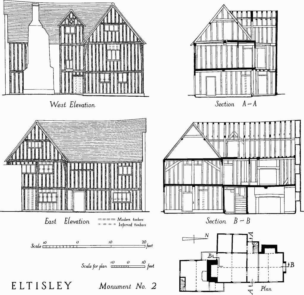
Eltisley, Monument No. 2
There are two principal rooms on the ground floor; these appear to have been separated by a narrow passage leading from a lobby at the foot of the stair to the rear of the house. This passage has been widened and the first four treads of the stair rearranged as a straight flight leading out of it. There are traces of an inner door between the lobby and the passage. The N. room, being reduced in size, now has a ceiling divided into four unequal bays by a primary ovolo-moulded axial beam, stopped at its N. end, and secondary chamfered cross beams. The S. room was originally entered at the W. end of its N. wall from the passage by a door, now blocked, with chamfered jambs and head. Its quadripartite ceiling has a primary axial and secondary cross beams, all stop-chamfered save at the S. end of the primary the butt of which is concealed in the later chimney breast. In the W. wall of this room are two symmetrically placed doorways which gave access to a room, probably a buttery, now divided by a modern partition under a stop-chamfered beam. The N. doorway is blocked; the S. doorway is closed by a reused door, of two panels, reinforced with nails and iron bands, said to have been brought from a manor house at Little Gransden.
Upstairs the general arrangement of the rooms resembles that on the ground floor save that the N. room, now sub-divided, is larger than the corresponding downstairs room by the width of the passage. It has a quadripartite ceiling of chamfered and stop-chamfered beams, the cross beam being the primary. The S. room also has a quadripartite ceiling. The primary, axial, beam has been re-tooled and may have been moulded; the secondaries are plain. W. of the S. room is a smaller one, at one time sub-divided, with a mutilated, perhaps formerly moulded, axial ceiling beam. It was entered from the S. room by a door, now blocked, above the more northerly of the two doors in the corresponding wall below. The staircase, save for the small alteration already noted, is spiral around an octagonal newel post and rises to the attics. Though partly boarded these can hardly have been habitable. The roofs have collars to main rafters and side purlins.
The outhouse, now floored, is divided into two bays by a stop-chamfered tie beam with collar over; the tie beam had braces, one of which survives, to its supporting uprights.
b(3) Green Farm, of two storeys, framed and plastered, with tiled roofs, is of the mid 17th century. It approximates in type to Class H but the smaller, W., cross wing, presumably accommodating a kitchen, seems originally to have been largely or entirely open to the roof. A number of alterations were made in the 18th century and subsequently, including the prolongation southward by one bay of the E. cross wing and the insertion of a floor into the W. cross wing. The original chimney at the junction of the main range and the W. cross wing retains its triple diagonal shafted stack in red brick.
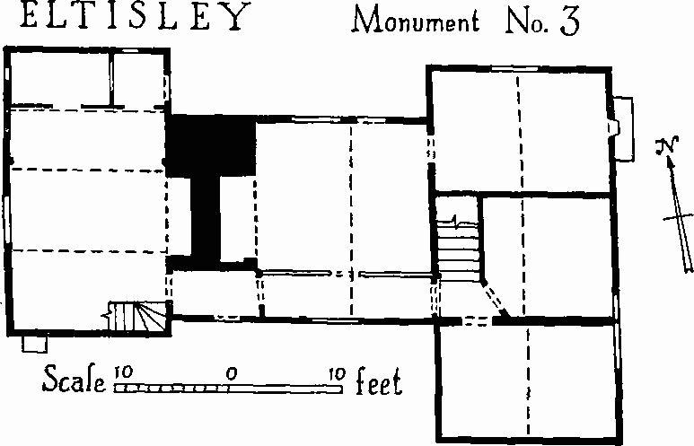
Eltisley, Monument No. 3
Inside, much of the structural timber is exposed including a number of straight internal braces from the principal uprights to their corresponding horizontal members. An original doorway, with shaped head, leading out of the kitchen immediately N. of the chimney has been blocked to allow for an added bread oven. Two original windows survive, also blocked, one divided into three lights by diagonal mullions. Built into a cupboard contrived out of the original kitchen fireplace is an old iron pot-crane.
b(4) Barn, at West Farm, framed and boarded, divided into three unaisled bays by tie beams with double braces to the posts, suggesting a 16th-century origin. The roof above the tie beams, covered with asbestos sheeting, and much of the studwork are modern.
b(5) Manor Farm, on a moated site (Monument (19)), partly of two storeys, partly of a single storey with attics, has its frame cased in modern brick, and tiled roofs. It was built in the late middle ages, apparently on a Class-D plan with a cross wing at the W. end and two-bay hall forming part of a range which extended further to the E. The house was remodelled in the 17th century when the hall was floored and a brick chimney and staircase intruded into its E. bay. Chimneys were also added at both ends of the house. In addition to the casing of the original fabric there are a number of modern additions, mostly on the S. side.
No original work is to be seen from the outside. Inside, the hall has a large stop-chamfered ceiling beam and stop-chamfered joists carrying the intruded floor. Above it is the main tie beam with stout arch braces to the posts but the roof is not visible. E. of the internal chimney is the 17th- or 18th-century staircase with turned balusters, moulded handrail and square newels with shaped finials. The E. end of the house, now comprising a single room on each floor, has a ground-floor ceiling carried on a chamfered cross beam, the underside of which is morticed for a studwork partition save at its S. end where a break in the chamfer and the absence of mortices indicate an original door. The W. cross wing originally had a single room on each floor. The ground-floor ceiling is carried on a roughly chamfered cross beam and some of the joists are exposed. These and the beam are numbered in such a way as to allow for a gap corresponding to two joists at the E. end of the beam, perhaps for a stair. The N. ends of the N. joists reflect the position of the original N. wall, since rebuilt in the same vertical plane as the formerly jettied upper stage. The upper room is divided but there are remains of a central braced tie-beam truss. A second staircase in the cross wing, also of the 17th or 18th century, has shaped balusters and newel posts with finials.
b(6) Jesus College Farm, two-storeyed, framed and plastered, with gabled and hipped roofs covered with tiles and pantiles, is of the early 17th century. It was built with a N.W. and S.E. main range of two rooms on each floor either side of an internal chimney and a cross wing at the N.W. end also of two rooms on each floor. The N.W. side of the cross wing has two added chimneys. The two rooms S.E. of the formerly internal chimney have been lost in modern times. Inside, the remaining ground-floor room of the main range has an ovolo-moulded beam stopped at the end opposite the chimney, and chamfered joists. The ceiling beams of the ground-floor rooms in the cross wing are ovolo-moulded and stopped. There are also some structural timbers exposed upstairs.
b(7) Pond Farm, on a moated site (Monument (18)), of two storeys, is an early Tudor L-shaped framed structure consisting of a N. and S. range with a N. cross wing. The long W. side to the green is continuously jettied. The low-pitched slated roofs, some brick underbuilding on the ground floor, the external chimneys and a lean-to in the angle are modern. Peculiarities of planning and the size of the two principal ground-floor rooms may imply a special-purpose building. Externally much of the timber is exposed but to the W. the upper wall is clad in asbestos sheeting. An unusual constructional feature is the use of small horizontal distance pieces pegged between the studs, some exposed, some buried in the plaster pan. Traces of a number of original openings survive but existing doors and windows are modern.
The ground floor of the cross wing was entirely occupied by one large room, now sub-divided, with ceiling of four and two half panels formed by two principal cross beams and axial secondaries, all moulded, and with moulded wall plates. To the S. in the range was a second room, also sub-divided, with a similar but quadripartite ceiling, some of the plain joists being exposed. Beyond it is a closet with plain ceiling beam and exposed joists. Surviving timbers on the upper floor are comparatively rough and poor; the wall-posts generally have enlarged heads and mortices for braces to tie beams.
b(8) The Leeds Arms, public house, two-storeyed with attics, of red brick with tiled roofs, was built towards the end of the 18th century at the approach to the village from Cambridge. The plan is that of a Class-T house but included lean-to semi-basements flanking a central stair turret on the N. back side. These semi-basements, which were presumably the cellars, have been heightened. The S. front is in three bays and two heights with central front door of six panels and pedimented hood carried on console brackets; the windows are hung-sash. There is a first-floor platband and two symmetrically placed set-back dormers. The end gables have parapets with plain kneelers.
b(9) House (Class D; Plate 98), two-storeyed, framed and plastered, with tiled roof, faces S. to the green and is of the late 15th or early 16th century. The main range is in three bays, the E. bay being originally a separate room, and, like the adjacent two-bay hall, open to the roof. Alterations of the 17th century include an extension to the N. end of the cross wing, an annexe at the E. end and the insertion of floors and a chimney into the main range. The S. front has been under-built in brick, now rendered, except for the projecting upper storey of the cross wing; and there is a modern lean-to along the N. side.
Much of the structural timber is exposed internally. The roofs are based on tie beams, collars and side purlins; that of the hall has long wind braces. In both the hall and the E. end room are traces of smoke blackening. In the upper S. room of the cross wing an original window (Plate 103), blocked, survives in the W. wall, divided into three lights by diamond mullions; over it is a groove cut in the top plate for a shutter or sash, and studwork immediately to the S. of the window is charred, apparently by rush lights or candles placed on the shutter guide shelf. The positions of other original windows on the ground floor at both ends of the cross wing can be inferred; that at the N. end was of three lights, that at the S. end probably of four lights. Traces also remain of original windows in the N. and S. walls of the hall; the S. window seems to have extended from the modern ground-floor window-sill level to the top plate, the intermediate plate forming a transom, with the upper and lower lights each sub-divided by a mullion. These four windows all had internal shutters or sashes; in the case of the S. hall window the upper and lower lights were shuttered separately.
b(10) Stonework, of the 16th to 18th centuries, built into, placed against or lying around the 'Mill House', a small dwelling of the second half of the 19th century (not listed) some 100 yds. N.E. of the church. Included are six short rectangular lengths carved with masks and fruit pendants, 16th-century; also a figure of a woman in classical costume, about half-life size and in bold relief, 16th- or 17th-century.
b(11–16) Houses, single-storeyed with attics and of internalchimney design, framed and for the most part still plastered and thatched, are of the 17th and 18th centuries.

Eltisley, Monument No. 9

Earthworks and Fields, Eltisley
Earthworks
b(17) Moated site (Class B; N.G. TL 268596, part on O.S.), around Monument (2) and to the S. of the church, appears to be that of an elaborate water garden connected and perhaps contemporary with the house. Much of the site is disturbed and overgrown.
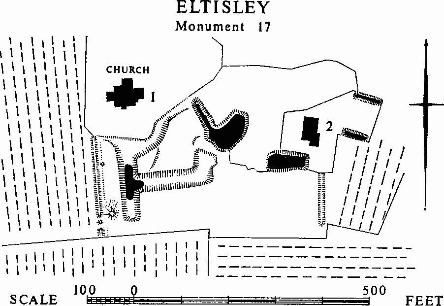
Eltisley, Monument 17
The principal feature is an irregular area immediately S.E. of the churchyard enclosed by a ditch: the W. side is 185 ft. long, including a 60–ft. continuation S. of its junction with the S. side; the N.W. side curves along the churchyard fence for 200 ft.; the E. side is only 76 ft. long and its S. end runs into a pond; the S. side is 160 ft. long with a short length projecting N. for 40 ft. The ditch is from 24 ft. to 40 ft. wide and from 5 ft. to 7 ft. deep. Parallel to the W. ditch, and 42 ft. from its W. edge is a bank 220 ft. long, 12 ft. wide and 2½ ft. high; at points just inside it, 50 ft. from either end are oval mounds, that to the N. being 8 ft. to 12 ft. across and 6 ins. high, that to the S. 30 ft. to 44 ft. across and 5 ft. high; there are gaps in the bank 7 ft. wide at two points near the S. end, and a slight internal ditch 13 ft. wide and 6 ins. to 9 ins. deep.
E. and N.E. of Monument (2), at distances respectively of 50 ft. and 100 ft., are two rectangular E. to W. ponds, parallel and each about 60 ft. by 18 ft. A third, similarly orientated, pond lies immediately S.W. of the house, and is 90 ft. by 45 ft. with a depth of 6 ft. at the E. end; 25 ft. to the S.E. of this last is a N. and S. ditch 115 ft. long, 15 ft. wide and 2 ft. to 3 ft. deep.
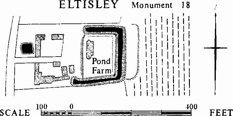
Eltisley, Monument 18
b(18) Moated site (Class A 1 (a); N.G. TL 273597), on the E. side of the village green on boulder clay; Pond Farm (Monument (7)) and its garden occupy much of the flat interior. A rectangular area about 145 ft. N. to S. by 110 ft. is enclosed on three sides by a wet ditch 30 ft. to 40 ft. wide and 4½ ft. deep, with a counter-scarp bank on the E., 40 ft. wide and 1½ ft. to 2 ft. high. The W. side has been destroyed and there is only a scarp 6 ft. to 7 ft. high falling from the interior to the farmyard, where a wide hollow indicates the approximate line of the ditch. Along the N. and E. sides is a ledge 8 ft. wide and 1½ ft. lower than the rest of the interior.
b(19) Moated site (Class A I (b); N.G. TL 273593), at Manor Farm (Monument (5)), on flat boulder clay. The moat is an irregular but roughly rectangular area, 230 ft. N. to S. by 180 ft. to 220 ft. surrounded by a wet ditch 30 ft. to 40 ft. wide and 2 ft. to 5 ft. deep. The entrance, a causeway now 50 ft. wide, may be original; a second causeway, on the S. side, 30 ft. wide, does not seem to be. The moat is fed by a spring at the S.E. corner where there is a rectangular pond.
The farm house stands within the moat on a platform 40 ft. wide, 2 ft. to 4 ft. above the general level and 60 ft. from the S. ditch. The E. half of the interior is covered by 19th-century buildings, but at the N.W. angle is a semi-circular platform 24 ft. across and 2 ft. high. There are indications in the present garden that a cobbled yard lay to the N. of the house and a wall along the W. edge of the moat.
b(20) Bank (N.G. TL 27405928–27615900, following hedgeline marked on O.S.), to the S.E. of the moated site (Monument (19)) at Manor Farm, in pasture. The bank, rounded, 10 ft. to 15 ft. wide, and 1½ ft. high, runs in a sweeping curve E. and S. to the N.E. angle of Eltisley Wood; it has an outer ditch 22 ft. wide and 1½ ft. deep and crosses N.E. to S.W. ridge and furrow.
b(21) Moated site (Class A 2 (b); N.G. TL 277593, not on O.S.), 90 yds. N.E. of Jesus College Farm (Monument (6)), in pasture with bushes along the ditches. The moat is trapezoidal, 85 ft. N.E. by 135 ft. E. by 135 ft. S. by 170 ft. N.W., and is surrounded by a ditch 25 ft. to 35 ft. wide, 4½ ft. to 5½ ft. deep, and 12 ft. to 15 ft. wide at the bottom. A counter-scarp bank 20 ft. wide and 1½ ft. high runs along the N.E. side. A stream enters the moat at the S.W. angle and flows along the W. side. There is a possible entrance in the centre of the E. side where cobbles can be seen in the E. scarp of the ditch. The interior is disturbed. Pottery of the 11th to 12th century has been found.

Eltisley, Monument 21
The moat lies in the S.W. corner of a rectangular area measuring 480 ft. N. to S. by about 400 ft., bounded on the W. by a stream, on the S. by a hedge, on the E. by a ditch 5 ft. to 10 ft. wide and 1 ft. deep, and on the N. by a ditch 15 ft. wide and 2 ft. deep.
a(22) Moated site (Class A 1 (a); N.G. TL 276614) on flat boulder clay in the N. of the parish at Papley Grove, is no doubt that of the house of the manor of Papley, mentioned as early as 1279 (Rot. Hund. (1818) II, 507–9). The enclosed island, which is flat and now occupied by an overgrown orchard, is 130 ft. N. by 110 ft. E. by 115 ft. S. by 110 ft. W. The surrounding wet ditch is generally 15 ft. to 20 ft. wide and 2 ft. deep to the level of the water, of which there is 2 ft. to 3 ft.; on the S. the ditch has however been widened to the S. to form a pond, in all 50 ft. to 70 ft. across.
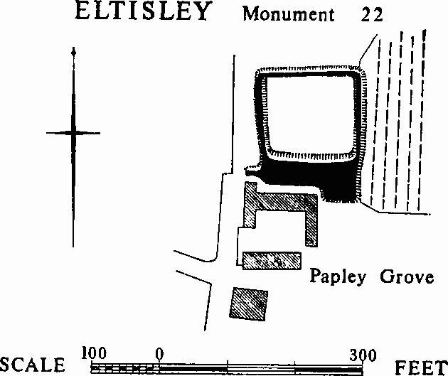
Eltisley, Monument 22
a(23) Windmill site (N.G. TL 278604, not on O.S.), on level ground 100 ft. S. of the Cambridge road. Only a patch of flint and pebbles is to be seen but the O.S. 1 in. map of 1836 and the tithe map of 1841 show a circular wet moat 140 ft. in diameter with an island in the centre endorsed 'Mill Hill'; this ditch is visible as a soil mark on a vertical air photograph (106G/UK/1490/3231).
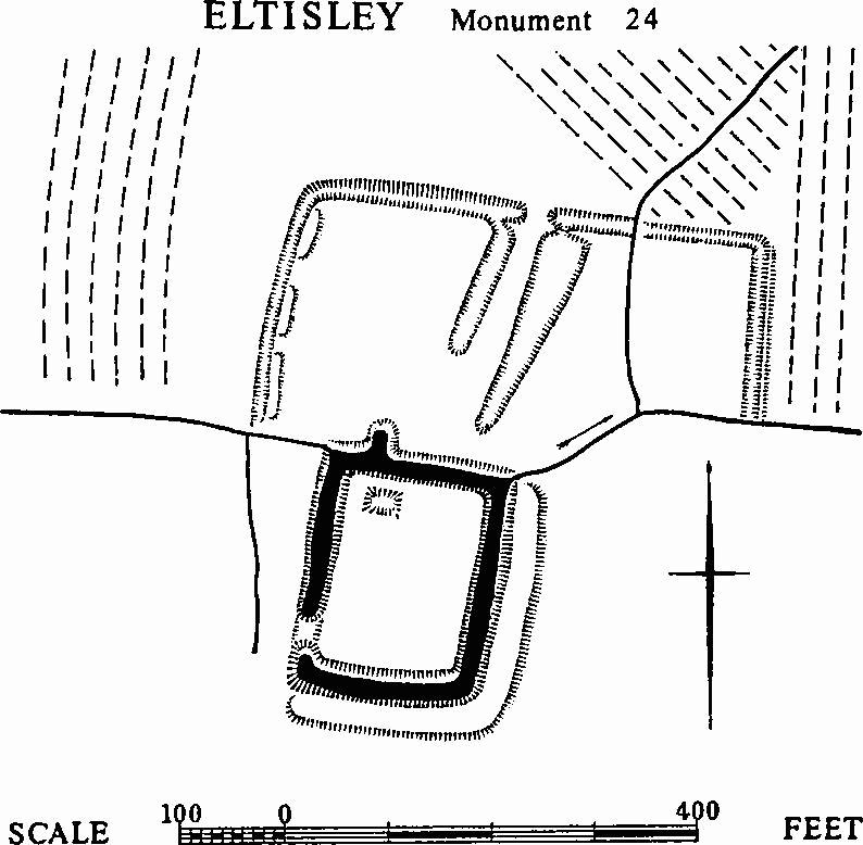
b(24) Moated site (Class A 2 (b); N.G. TL 274589, moat and parts of the enclosure on O.S.), at the N. edge of Eltisley Wood, comprises a moat and an outer enclosure. 13th-century pottery has been found on the surface inside the moat.
The island enclosed by the moat is rectangular, 180 ft. N. to S. by 130 ft., with a wet ditch 30 ft. to 35 ft. wide, 4 ft. to 5½ft. deep, and 15 ft. wide at the water level; on the E. and S. sides is an outer bank 25 ft. wide and 1½ ft. high. The interior, flat and raised 2 ft. above the surrounding area, is entered by a causeway on the W. side, 15 ft. wide but apparently not original. It is flanked on the inside by long narrow hollows, perhaps former ponds. A projection from the N. ditch seems to be modern.
Eltisley, Monument 24
The outer enclosure, under pasture, lies to the N. and N.E. A stream flowing through the N. side of the moat continues to the E. and W. as the boundary of the wood. From this stream, at a point 60 ft. W. of the N.W. corner of the moat, a ditch branches N.N.E., running for 250 ft. before turning E., parallel to the stream. This N. side is broken 200 ft. from its W. end by a causeway 24 ft. wide, and again, 84 ft. further E., by a relatively modern cut; beyond this point it continues as a slight ditch for 105 ft. and then turns S. for 165 ft. to meet the stream bounding the wood. The W. side of this outer enclosure is 17 ft. wide and 1 ft. deep, with a disturbed inner bank 15 ft. wide and 9 ins. high; the adjoining length to the N. is 26 ft. wide and 2½ ft. deep and has no inner bank; the E. side is accompanied by an external bank 10 ft. wide and 9 ins. high.
(25) Cultivation remains (not on O.S.). Ridge and furrow, formerly all in old enclosures, remains over a considerable area S. of the village and to the N. and E. of Papley Grove. The remains are 70 yds. to 260 yds. long with ridges 6 yds. to 12 yds. wide and 9 ins. to 1 ft. high; the headlands are 8 yds. to 10 yds. wide. Much of these remains appear, from their reversed-S curved form, e.g. at N.G. TL 279594 and 275590, to have been enclosed from the open fields. It is just possible that the large area of old enclosure S. of the village may be connected with the fact that Henry de Nuthale had a deer park in the parish in 1241 (Close Rolls, Henry III, IV (1911), 264).
Traces of ridge and furrow of the former open fields can be seen on air photographs covering much of the parish. These traces correspond exactly with the open field lay-out, planned on the tithe map of 1841 (which shows individual furlong names), and not enclosed until 1864. There were three open fields: 'Easton', 'Middle' and 'Papley' Fields.
(Ref: Close Rolls 1241; tithe map 1841 (T.R.C.); enclosure map 1865 (C.R.O.); air photographs: 106G/UK/1490/3230–32.)