Ancient and Historical Monuments in the County of Gloucester Iron Age and Romano-British Monuments in the Gloucestershire Cotswolds. Originally published by Her Majesty's Stationery Office, London, 1976.
This free content was digitised by double rekeying. All rights reserved.
'North Cerney', in Ancient and Historical Monuments in the County of Gloucester Iron Age and Romano-British Monuments in the Gloucestershire Cotswolds(London, 1976), British History Online https://prod.british-history.ac.uk/rchme/ancient-glos/pp85-86 [accessed 13 April 2025].
'North Cerney', in Ancient and Historical Monuments in the County of Gloucester Iron Age and Romano-British Monuments in the Gloucestershire Cotswolds(London, 1976), British History Online, accessed April 13, 2025, https://prod.british-history.ac.uk/rchme/ancient-glos/pp85-86.
"North Cerney". Ancient and Historical Monuments in the County of Gloucester Iron Age and Romano-British Monuments in the Gloucestershire Cotswolds. (London, 1976), British History Online. Web. 13 April 2025. https://prod.british-history.ac.uk/rchme/ancient-glos/pp85-86.
NORTH CERNEY
(3 miles N. of Cirencester)
A small camp was said to lie close to the White Way (4); Rudder thought it of 'considerable extent', but Witts found it too flattened for interpretation. There are possible traces on air photographs of a circular ditched enclosure at SP 027075, 300 yds. W. of the White Way. (fn. 1) In Calmsden Field (? SP 0409) an 'outpost, with circumvallations' and a Roman 'lachrymatory' of blue glass were noted 'on the Downs'. (fn. 2) Finds from Downs Farm are described under Baunton (1), p. 13.
There are scarps, some possibly of 'Celtic' fields, on the spur N. of Old Park, about SP 009096 (cf. N.M.R., OAP SP 0009/1/338–9).
(1) Scrubditch, see p. 8, s.v. Bagendon.
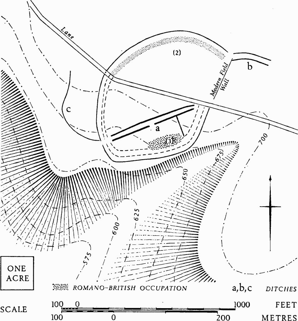
(2) Hill-fort (SO 996095), W. of the hamlet of Woodmancote, univallate and about 10 acres in area although largely destroyed, unexcavated, has recently been rediscovered from the air by W. A. Baker (Plate 36). It lies in part in an area called 'The Ditches' on drawings made for the first O.S., c. 1815, where the N. half is marked as a curving boundary. The bank and ditch around the S. half, not clearly seen on the ground, perhaps suffered destruction in Roman times when a settlement (3) was established in the S. part of the hillfort.

North Cerney. (2) Hill-fort near Woodmancote. (3) Romano-British Settlement.
The N. half of the hill-fort is on almost flat ground. Its E. side probably corresponds with a modern field wall. The ditch is still visible on the N. and W. sides as a depression about 40 ft. wide and up to 3 ft. deep, below a low spread bank. The S. half drops slightly to a small spur on the shoulder of the Great Oolite ridge. There are indications of a spread stone bank on the W. side, and air photographs taken in 1971 show a probable entrance at S.W. In the N. half of the hill-fort there are indications of one or two platforms, perhaps for structures.
N.M.R., OAP (Baker) SO 9909/2 and 3; 9909/7/291–3; 9909/8/362–5; 9909/13/80–2.
(3) Romano-British Settlement (SO 996093), under arable inside the hill-fort (2), is identified from patches of limestone blocks, some of them squared, associated with other building debris and pottery, mostly found in the S. of the hill-fort. Crop-marks of parallel ditches (a), defining a way about 30 ft. wide, extend across the area towards the hill-fort entrance; the northern ditch may be continued by ditch (c). A second pair of parallel ditches (b) meets the hill-fort at N.E.
Finds of pottery, mostly of the 3rd and 4th century, include Oxfordshire mortaria and colour-coated wares, with one or two pieces of samian.
Air photographs as for (1); also SO 9909/7/294–5 (N.E. ditches).
(4) White Way (i, SP 030068–SP 030076; ii, SP 02930825– SP 02970908), probable Roman road. The agger is suggested at (i) by a line of much-disturbed bank in Long Plantation, and at (ii) by the scattered stony remains of a wide, low bank, without a ditch, in the arable field S.W. of Nordown; a further wide, low bank continues in the field to the north. Both features are visible on a vertical air photograph. A hollow running close to (i) on the E. side might be explained as a worn track, but there is no sign of it beside (ii).
R.A.F., VAP CPE/UK 2098: 3006.