Ancient and Historical Monuments in the County of Gloucester Iron Age and Romano-British Monuments in the Gloucestershire Cotswolds. Originally published by Her Majesty's Stationery Office, London, 1976.
This free content was digitised by double rekeying. All rights reserved.
'Haresfield', in Ancient and Historical Monuments in the County of Gloucester Iron Age and Romano-British Monuments in the Gloucestershire Cotswolds(London, 1976), British History Online https://prod.british-history.ac.uk/rchme/ancient-glos/pp62-64 [accessed 5 May 2025].
'Haresfield', in Ancient and Historical Monuments in the County of Gloucester Iron Age and Romano-British Monuments in the Gloucestershire Cotswolds(London, 1976), British History Online, accessed May 5, 2025, https://prod.british-history.ac.uk/rchme/ancient-glos/pp62-64.
"Haresfield". Ancient and Historical Monuments in the County of Gloucester Iron Age and Romano-British Monuments in the Gloucestershire Cotswolds. (London, 1976), British History Online. Web. 5 May 2025. https://prod.british-history.ac.uk/rchme/ancient-glos/pp62-64.
HARESFIELD
(16 miles W.N.W. of Cirencester)
A Romano-British cemetery, reported from 'a spot in the Weald', (fn. 1) appears to be additional to that noted below (4). Skeletons lying N.—S., pottery and a quern fragment were observed.

Monuments in Harescombe and Haresfield.
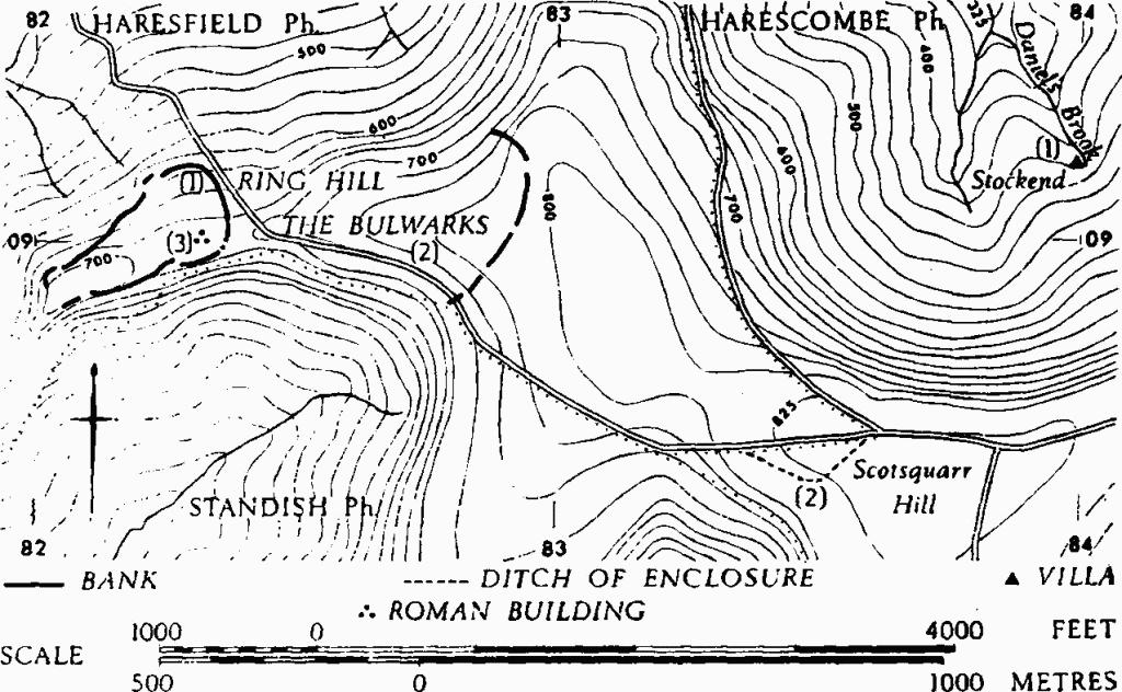
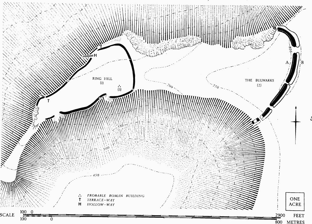
(1) Hill-fort on Ring Hill (SO 822090), univallate with traces of internal quarry pits but without external ditch, unexcavated, encloses nearly 10 acres at the end of a spur of the Cotswold escarpment, one mile S.E. of the village.
The N. and S. sides are defined by banks, set along the edges of the scarp, varying in size from very slight to 30 ft. wide and 4 ft. high (at N.W.); the E. bank, about 2½ ft. high, rises to follow the crest of a natural ridge above a gully. The W. end, at the tip of the spur and formerly the site of a beacon, is entirely broken by quarrying. Of the five gaps in the bank two on the N. are approached by terrace-ways, probably following original lines; a third gap is approached by a hollowway. Two large gaps in the S. bank are at least partly due to quarrying.

Haresfield. (1) Hill-fort on Ring Hill. (2) The Bulwarks.
Part of a saddle-quern found in the E. half of the interior is in Gloucester City Museum.
S. Lysons, Woodchester (1797), plan of 'Broadridge Green' inset in 'Map of the Roman Stations'. Lloyd-Baker (1821), 169, No. 16. Playne (1876), 211, No. 21 (Haresfield Beacon). Witts (1883), 23, No. 47 (Roman Camp).
(2) The Bulwarks (fn. 2) Hill-fort (SO 829091), unexcavated, consists of a single bank with an outer ditch crossing the neck of the spur, 630 yds. E. of Ring Hill (1). Plan, p. 63.

Haresfield. (2) The Bulwarks. Profile A-B (p. 63).
The bank, 45 ft. wide and 7 ft. high, is of glacis construction externally and has a ledge 2 ft. high and up to 10 ft. wide along the inner side; the ditch is 40 ft. wide and 7 ft. deep. The slope from bank to ditch is lengthened at the N. end, where the ditch runs into a gully and the bank curves away along the edge of the scarp. Four gaps in the bank, 20 ft. to 80 ft. wide, have corresponding causeways in the ditch. A hollow-way enters the N. end of the ditch by way of the gully.
A few sherds of featureless hand-made pottery, found in ploughsoil in the field to the W. of the bank, are now in Gloucester City Museum.
Bibliography as in (1).
(3) Roman Building (SO 82320900), on Ring Hill (see p. 63), occurs near the E. end of (1). A scatter of pottery, tile fragments and limestone slabs suggests occupation near the E. entrance in the S. side, where a pot was found in 1837 containing from 2,000 to 3,000 bronze coins. Pottery, part of a rotary quern and animal bones, exposed by landslips on the slope outside the hill-fort bank at N.E., may be refuse from this settlement.
The hoard is said to have consisted mainly of issues of the period A.D. 306–40; many coins were in mint condition. Two coins to survive from the hoard (Claudius Gothicus and Constantine) are in Gloucester City Museum. The same museum has records of two recent finds, one a bronze coin of Constantine II. An Urbs Roma in mint condition, now in Stroud Museum, is attributed to the hoard. Fragments of glass vessels and 3rd-4th-century pottery are in G.C.M.
J. D. T. and C. S. Niblett, MS. Commonplace Book (1834– 8), 287–9 (in Gloucester Public Library). J. Buckman and C. H. Newmarch, Illustrations of the Remains of Roman Art in Cirencester, the Site of Antient Corinium (1850), 6. PCNFC, XXI (1922), 79, 141–50.
(4) Romano-British Cemetery (SO 815120), on Long Hill, Colethrop, S. of the Shorn Brook, lies in the vale at about 90 ft. above O.D. Several skeletons were discovered when drains were laid, c. 1847, some of them in stone cists. Samian ware, coarse pottery, an illegible coin and a bronze figurine were also found.
JBAA, II (1847), 96. TBGAS, 90 (1971), 53.
(5) Romano-British Settlement (SO 819115), in 'The Lessons' at Colethrop near the S. bank of the Shorn Brook, ⅓ mile S.E. of (4), is indicated by pottery of the 2nd and 3rd centuries and building debris in an area of shallow banks and depressions, all ploughed over.
TBGAS, 90 (1971), 53.