Ancient and Historical Monuments in the County of Gloucester Iron Age and Romano-British Monuments in the Gloucestershire Cotswolds. Originally published by Her Majesty's Stationery Office, London, 1976.
This free content was digitised by double rekeying. All rights reserved.
'Duntisbourne Rouse', in Ancient and Historical Monuments in the County of Gloucester Iron Age and Romano-British Monuments in the Gloucestershire Cotswolds(London, 1976), British History Online https://prod.british-history.ac.uk/rchme/ancient-glos/pp48-49 [accessed 13 April 2025].
'Duntisbourne Rouse', in Ancient and Historical Monuments in the County of Gloucester Iron Age and Romano-British Monuments in the Gloucestershire Cotswolds(London, 1976), British History Online, accessed April 13, 2025, https://prod.british-history.ac.uk/rchme/ancient-glos/pp48-49.
"Duntisbourne Rouse". Ancient and Historical Monuments in the County of Gloucester Iron Age and Romano-British Monuments in the Gloucestershire Cotswolds. (London, 1976), British History Online. Web. 13 April 2025. https://prod.british-history.ac.uk/rchme/ancient-glos/pp48-49.
DUNTISBOURNE ROUSE
(4 miles N.W. of Cirencester)
A poorly marked Dyke (SP 001075) in the E. of the parish is described s.v. Bagendon (1), p. 9.
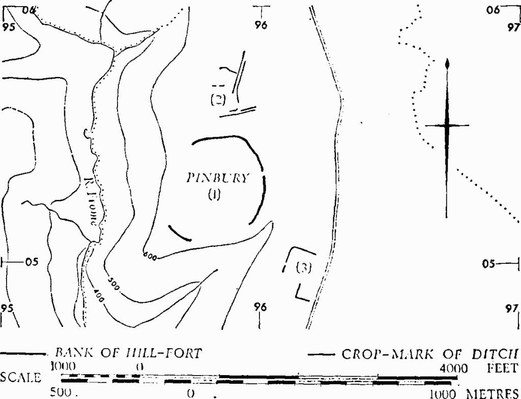
(1) Pinbury Hill-fort (fn. 1) (SO 958053), univallate, unexcavated, encloses about 25 acres on a spur between the valleys of the R. Frome and a tributary, 2 miles S.W. of the village. The N. and E. sides are defined by a bank with an outer ditch almost levelled by ploughing; the relationship between the ends of the bank and the scarps to S. and W. is not clear. A degraded bank cuts across the S.W. tip of the spur. An entrance about 30 ft. wide occurs in the middle of the E. side.
A few featureless sherds of hand-made pottery from ploughsoil over the bank, and fragments of abraded Romano-British pottery from the interior of the hillfort, are in Gloucester City Museum.
R.A.F., VAP 3G TUD/UK 102: 5025–6. C.U.A.P., OAP AMK 71, AMZ 61, ATZ 80.
Monuments in Duntisbourne Rouse.
(2) Crop-marks (SO 959056), centred 200 yds. N. of the main bank of (1), suggest the conjunction of wide tracks.
(3) Crop-marks (SO 962050), centred 300 yds. S.E. of the main bank of (1), appear to represent parts of two rectangular enclosures.
(4) Romano-British Settlement (SO 997074), Stancombe, S.E. of Dartley Farm (plan, p. 50), marked by some well-preserved platforms and by others greatly disturbed, covers some 10 acres of a sheltered valley-side, facing S.E. (Plate 50). Other traces of settlement or of associated fields extend W. over a further 5 acres. Water gushes profusely at the spring-line, high up the valley-side at the junction of the Great Oolite and the Fuller's Earth. On a natural shelf at this level a rectangular mound contains the footings of a Roman building (a), recently uncovered. A broken block of worked limestone, probably Roman, lies in the nearby springhead (e). Romano-British building and occupation debris (b) occurs in soil which has slipped down from the brow of the steep slope above the building (a) and is exposed above a terraced farm track. At a lower level, trial cuts (c and d) in the narrow platforms which cover much of the site show that the forward edges of these platforms consist of earthy rubble; small potsherds were found in both cuts, also sandstone (c) and a single small tessera (d). Below the platforms, narrow terraced plots, sloping in cross-section, are an unusual feature. The E. part of the settlement area is greatly disturbed by quarrying. A small platform (f), probably for a building, has much dark matter in its surface soil. The stream in the S., flowing E. to the Briting Brook on the parish boundary with Bagendon about 300 yds. away, appears to be the boundary of the settlement.
The recently excavated building (a) occupies the E. end of a mound, 80 ft. long, 40 ft. wide and up to 6 ft. high. In the W. part of the excavated area (12 ft. by 10 ft.) is the angle of a room with walls of coarse Oolite masonry 2 ft. thick. The angle contains a flue, infilled and covered by a pavement of large earthenware tesserae (Plate 51). The remains of a later wall are built directly on the pavement. On the E., a wall of fine coursed Oolite abuts the external angle of the room, and in the space so defined is a stone-floored hearth. The building has foundations of clay and limestone rubble. Other building materials in the mound include pila tiles. box-tiles and sandstone 'slates'. Dating evidence as yet is sparse; a minimus was found above the tessellated floor.
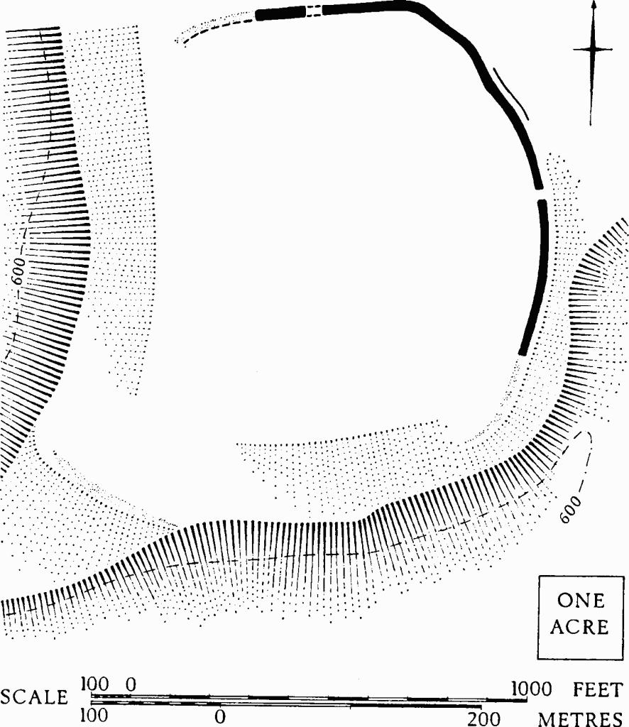
Duntisbourne Rouse. (1) Pinbury Hill-fort.
Information from the excavators, Mr. M. K. Baker and Mr. J. Partridge.