Ancient and Historical Monuments in the County of Gloucester Iron Age and Romano-British Monuments in the Gloucestershire Cotswolds. Originally published by Her Majesty's Stationery Office, London, 1976.
This free content was digitised by double rekeying. All rights reserved.
'Cranham', in Ancient and Historical Monuments in the County of Gloucester Iron Age and Romano-British Monuments in the Gloucestershire Cotswolds(London, 1976), British History Online https://prod.british-history.ac.uk/rchme/ancient-glos/pp40-41 [accessed 5 May 2025].
'Cranham', in Ancient and Historical Monuments in the County of Gloucester Iron Age and Romano-British Monuments in the Gloucestershire Cotswolds(London, 1976), British History Online, accessed May 5, 2025, https://prod.british-history.ac.uk/rchme/ancient-glos/pp40-41.
"Cranham". Ancient and Historical Monuments in the County of Gloucester Iron Age and Romano-British Monuments in the Gloucestershire Cotswolds. (London, 1976), British History Online. Web. 5 May 2025. https://prod.british-history.ac.uk/rchme/ancient-glos/pp40-41.
CRANHAM
(9 miles N.W. of Cirencester)
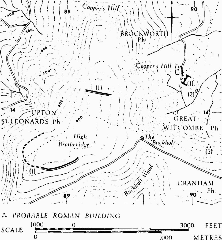
Earthworks probably of the Iron Age on High Brotheridge, extending into Upton St. Leonards, are incomplete. Suggestions that they were linked with other earthworks to the N., on Cooper's Hill in Brockworth, are considered below.
An Iron Age pot with expanded rim and fingerprints on the neck is alleged to have contained a cremation and to have been found in 'the round barrow at Ebworth' in 1882. (fn. 1) The mound, not precisely located, may not have been a barrow. (fn. 2)

Monuments in Brockworth, Great Witcombe and Cranham.
(1) Dyke (SO 888138), High Brotheridge, probably of the Iron Age and possibly part of a former or unfinished enclosure, comprises a degraded bank or scarp with an outer ditch, bounding the S.W. parts of High Brotheridge hill, between 850 and 900 ft. above O.D. The ground slopes gently downhill at first, and then steeply, except at the W. extremity where there is an immediate steep fall into Buckholt Wood and the adjoining Rough Park. Indications of another bank with an uphill ditch or hollow, shown on O.S. 6-inch maps just W. of this place, coincide with a track approaching an old quarry in Rough Park.
The bank first mentioned ends sharply to the E., where a gully crosses the hill-top. The bank is now 27 ft. across at most and 4 ft. high above a ditch of similar width. Witts (1883) suggests a former height of 15 ft., but his description is unusually difficult to reconcile with the existing remains. The main bank is arranged in a series of straight lines. Slight banks and scarps in Brockworth are either natural or undatable. A sinuous scarp line shown on O.S. maps, following the E. side of Cooper's Hill, N. of the transverse gully, is at most 3 ft. high and is crossed by the parish boundary bank. A small bank tops the scarp in places N. of this, and the dyke in Brockworth (1) ends against this scarp line. Northwards from about so 89371438 the line is continued by a slight bank with a ditch on its W. side.
C.U.A.P., OAP ACQ 54–7.
Arch, XIX (1821), 170. Witts (1883), 15, No. 32. Burrow (1924), 130. Bagendon, 157–8.