Ancient and Historical Monuments in the County of Gloucester Iron Age and Romano-British Monuments in the Gloucestershire Cotswolds. Originally published by Her Majesty's Stationery Office, London, 1976.
This free content was digitised by double rekeying. All rights reserved.
'Uley', in Ancient and Historical Monuments in the County of Gloucester Iron Age and Romano-British Monuments in the Gloucestershire Cotswolds(London, 1976), British History Online https://prod.british-history.ac.uk/rchme/ancient-glos/pp121-123 [accessed 13 April 2025].
'Uley', in Ancient and Historical Monuments in the County of Gloucester Iron Age and Romano-British Monuments in the Gloucestershire Cotswolds(London, 1976), British History Online, accessed April 13, 2025, https://prod.british-history.ac.uk/rchme/ancient-glos/pp121-123.
"Uley". Ancient and Historical Monuments in the County of Gloucester Iron Age and Romano-British Monuments in the Gloucestershire Cotswolds. (London, 1976), British History Online. Web. 13 April 2025. https://prod.british-history.ac.uk/rchme/ancient-glos/pp121-123.
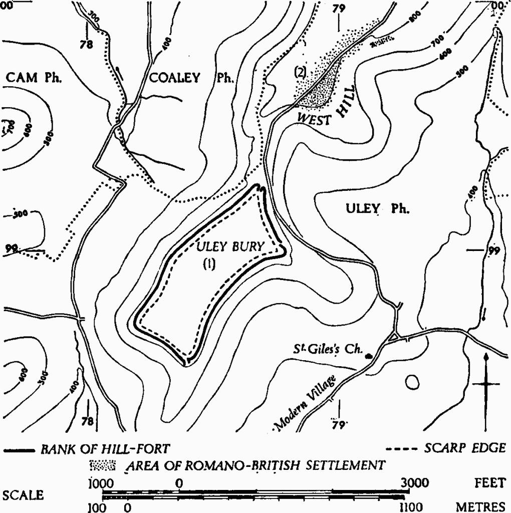
ULEY
(15 miles W.S.W. of Cirencester)
An uninscribed Dobunnic gold stater (Allen's type British R A), (fn. 1) together with more than 150 Roman coins ranging from the 2nd to the 4th century, (fn. 2) and a bronze mask (fn. 3) were reported in the 19th century from the vicinity of monuments (1) and (2). Three coins, probably Constantinian, were noted with a secondary inhumation in the long barrow named Hetty Pegler's Tump (SO 78950004), 400 yds. N. of (2). (fn. 4)
Monuments in Uley.
(1) Uley Bury Hill-fort (ST 784989), univallate, unexcavated, is situated on a prominent spur of the Cotswold escarpment above the village (Plate 33). The bank encloses 38 acres, 6 acres of which are occupied by the terrace described below. Plan, p. 122.
The bank, up to 35 ft. wide and 4 ft. high, stands along the edges of a terrace, 30 ft. to 60 ft. wide overall, probably created by the digging out of material to make the bank. A scarp 3 ft. to 13 ft. high rises from the inner side of the terrace to the level interior, now arable. Externally, the scarp falls from the bank an average of 30 ft. to a greatly disturbed narrow ledge, apparently not a ditch, but probably associated with the defences. There are three entrances. Access from the N. is by way of a col, the inturned ends of the banks with a short hollow-way between them lying obliquely across it. Outside the N. entrance a series of banks and ditches across the col have been noted (Arch, XIX (1821), Pl. xi); most of them have gone and surviving features appear to be natural. At the E. corner overlapping bank-ends are associated with a hollow-way. At the damaged S. entrance another hollow-way is flanked on the W. by a down-slope extension of the bank and, at the edge of the terrace, by two partly artificial mounds. Roads shown on O.S. 1815 passed through the E. and S. entrances and traversed the eastern terrace.
Air photographs of crop-marks (N.M.R., OAP ST 7898/1/219–24) show ditched enclosures inside the hill-fort (Plate 32).
Recent finds, now in Gloucester City Museum, include small sherds of hand-made pottery and animal bones found beneath the eroded S. bank, also a saddle quern from the interior. 'Hand-mullers' were reported in 1876 (PCNFC, VI, 12). Finds now in Stroud Museum include an everted rim sherd of Iron Age type, found in the interior. A coin of Salonina is reported from the interior (Glos. Notes & Queries, I (1881), 320, n. cccxxvi), where also other 3rd-century coins are said to have been found (TBGAS, XXXV (1912), 151).
C.U.A.P., OAP AIO 11–15, AJL 16.
Lloyd Baker (1821), 167, No. 15. Playne (1876), 11, No. 28. Witts (1883), 50, No. 104. Arch J, CXXII (1965), 213.
(2) Romano-British Settlement (ST 790996), covering at least 7 acres on West Hill, lies about 500 yds. N.E. of (1) and immediately above the col which links Uley Bury with the main Cotswold escarpment.
A Dobunnic silver coin inscribed EISV has recently been found in the settlement area.
Occupation debris in arable fields on either side of the modern road includes worked limestone, sandstone tiles, tesserae, and animal bones. Over 60 coins found in 1966–70 extend from Trajan (issues of 101–2) to Theodosius. Numerous small finds include two almost identical and unusual intaglios, a bronze boss bearing a human face, a votive object, rings, a pin, a brooch and a bronze nail-cleaner. Pottery, including samian, ranges in date from the 1st to the 4th century, apart from one sherd of grass-tempered ware probably datable to the 5th century or later. Some of the recent finds are in private possession, others are in Stroud and Gloucester City Museums; one intaglio is in Stroud, the other in Gloucester.
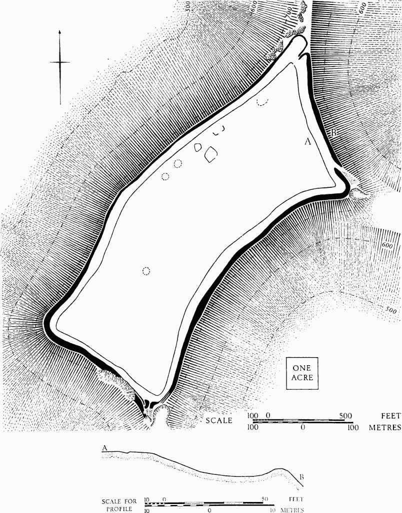
Uley. (1) Uley Bury Hill-fort. Plan and profile.
Finds made c. 1873 and now lost are said to have included some 50 coins of the 3rd and 4th centuries, samian and coarse wares, mortaria, and animal and human bones.
Glos. Notes & Queries, I (1881), 319, n. cccxxvi. TBGAS, 87 (1968), 204, Nos. 13, 14.