Ancient and Historical Monuments in the County of Gloucester Iron Age and Romano-British Monuments in the Gloucestershire Cotswolds. Originally published by Her Majesty's Stationery Office, London, 1976.
This free content was digitised by double rekeying. All rights reserved.
'Condicote', in Ancient and Historical Monuments in the County of Gloucester Iron Age and Romano-British Monuments in the Gloucestershire Cotswolds(London, 1976), British History Online https://prod.british-history.ac.uk/rchme/ancient-glos/p39 [accessed 5 May 2025].
'Condicote', in Ancient and Historical Monuments in the County of Gloucester Iron Age and Romano-British Monuments in the Gloucestershire Cotswolds(London, 1976), British History Online, accessed May 5, 2025, https://prod.british-history.ac.uk/rchme/ancient-glos/p39.
"Condicote". Ancient and Historical Monuments in the County of Gloucester Iron Age and Romano-British Monuments in the Gloucestershire Cotswolds. (London, 1976), British History Online. Web. 5 May 2025. https://prod.british-history.ac.uk/rchme/ancient-glos/p39.
CONDICOTE
(18 miles N.N.E. of Cirencester)
The pit-alignment (1) is one of only three examples in the Gloucestershire Cotswolds, rare in its situation (see p. xxvii). The Roman road, Ryknild Street, ran through the parish just E. of (1) and (2), but no sign of it is now seen.
Of four enclosures formerly noted in the parish only one, incomplete and much flattened, can be substantiated; it is a 3-acre circular earthwork, 200 yds. E. of the church (SP 154284), with a large causewayed ditch inside its single bank (X on map, p. xxxii). Although an Iron Age sherd has been found high in the main fill of the ditch, the earthwork is probably of Neolithic 'henge' type. (fn. 1) An undated enclosure of 1 acre on Staites Brake (SP 150302), called 'Hinchwick Camp' in VCH, was almost flattened in 1803 and the present enclosure is modern (p. xxxii). An 'oval British camp' reported W. of the village (fn. 2) cannot be confirmed; there are rings and semicircles of geological origin in this area and to the north. Immediately E. of these are the alleged remains of a hill-fort, Eubury Camp, (fn. 3) which cannot be accepted as such on present evidence (p. xxxi). In 1937 Romano-British pottery was found just W. of the 'hill-fort'. (fn. 4)

Monuments in Condicote.
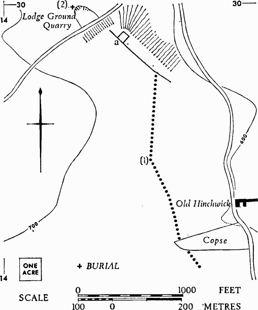
(1) Pit-alignment, Ditch and Enclosure (SP 14562923– 14312993) show as crop-marks above the indented W. side of a dry valley (Plate 56). The pit-alignment extends for 630 yds. across the head of two minor reentrants W. of Old Hinchwick, thence N. across gently sloping ground to an almost level shelf; here it meets a ditch at least 300 yds. long above a steep drop to the east. A rectangular enclosure (a) of about 1/5 acre projects from the E. side of the ditch near its N. end. Beyond the ditch the ground drops sharply into a narrow gully, N. of which was the Romano-British burial noted below.
N.M.R., OAP SP 1429/1/346–51.
(2) Romano-British Inhumation (SP 14202999) (map with (1)), crouched, associated with an iron-hinged wooden container in a partly stone-lined grave dug into limestone bedrock, was exposed at the W. end of Lodge Ground Quarry in 1937. The ground drops sharply just N. of the now derelict quarry. A bronze pin probably from the grave is in Cheltenham Museum.
TBGAS, 61 (1939), 109.