Ancient and Historical Monuments in the County of Gloucester Iron Age and Romano-British Monuments in the Gloucestershire Cotswolds. Originally published by Her Majesty's Stationery Office, London, 1976.
This free content was digitised by double rekeying. All rights reserved.
'Coates', in Ancient and Historical Monuments in the County of Gloucester Iron Age and Romano-British Monuments in the Gloucestershire Cotswolds(London, 1976), British History Online https://prod.british-history.ac.uk/rchme/ancient-glos/p32 [accessed 5 May 2025].
'Coates', in Ancient and Historical Monuments in the County of Gloucester Iron Age and Romano-British Monuments in the Gloucestershire Cotswolds(London, 1976), British History Online, accessed May 5, 2025, https://prod.british-history.ac.uk/rchme/ancient-glos/p32.
"Coates". Ancient and Historical Monuments in the County of Gloucester Iron Age and Romano-British Monuments in the Gloucestershire Cotswolds. (London, 1976), British History Online. Web. 5 May 2025. https://prod.british-history.ac.uk/rchme/ancient-glos/p32.
COATES
(3 miles w. of Cirencester. Map, p. 31)
(1) Trewsbury Hill—fort (ST 981998), partly bivallate, unexcavated, encloses about 12 acres on a spur at the edge of a shallow valley, 200 yds. N. of the source of the R. Thames and ¾ mile S. of the village.
The E. and S. sides are defined by two widely spaced banks, each with an outer ditch; the W. and N. sides are disturbed. The inner bank, 24 ft. wide and 2½ ft. high, has a ditch 30 ft. wide and 3 ft. deep. Traces of an exterior revetment wall were noted in pole-holes in 1966. The entrance, now obliterated, was in the N.E. The outer bank, 45 ft. wide and 6 ft. high, with a ditch 35 ft. wide and 4 ft. deep, turns sharply at its southern— most point and proceeds N.W. to join the inner bank. There is an entrance 200 ft. E. of the turn; another gap 240 ft. further E. is less certainly original.
Part of a low bank without a ditch in the N.W. of the fort is set between the steep westward fall of the spur and a secondary scarp; a slighter bank turns inward from its S. end.
In 1895 it was reported that Roman coins had been found within the hill-fort, and Roman pottery was found. In 1937 marks of a rectangular structure were noted in the turf between the ramparts at S.
Playne (1876), 215, No. 33. Witts (1883), 50, No. 103. PCNFC, III (1865), 124; VI (1877), 215. A. L. F. Rivet, in IASB, 34. Information from Mrs. H. E. O'Neil.
(2), (3) Buildings (SO 965003), probably Roman, are indicated by crop—marks S.E. of Hailey Wood (see Sapperton (1), p. 99).
(4) Roman Building (SO 96530036), indicated by scattered masonry and pottery; see Sapperton (1), p. 99.
(5) Linear Ditches (SO 969012), two, parallel and about 20 ft. apart, show as crop-marks 450 yds. N.W. of St. Matthew's church (plan on parish map); possibly they represent a drove. Another ditch extends N.—S. immediately to the E.
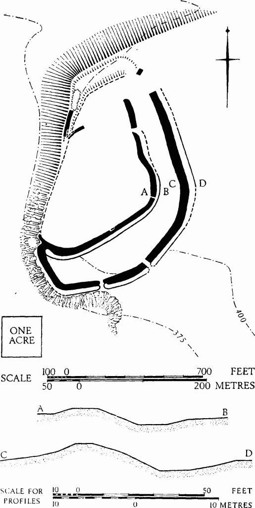
Coates. (1) Trewsbury Hill-fort.
C.U.A.P., OAP AXO 85.
(6) Enclosure (SO 984009), (Plate 58) undated and largely ploughed over, together with other rectilinear and curving features, cover an area of about 16 acres N. and N.W. of Bledisloe Lodge. Where unploughed the enclosure bank is 10 ft. wide and 1½ ft. high, with an outer ditch 20 ft. wide and 1½ ft. deep. Discrete lengths of bank on W. and S. are similar in character.
O.S., VAP 65.17, 060. N.M.R., OAP SO 9800/5 (Baker).