A History of the County of Lancaster: Volume 8. Originally published by Victoria County History, London, 1914.
This free content was digitised by double rekeying. All rights reserved.
'Townships: Upper Holker', in A History of the County of Lancaster: Volume 8, ed. William Farrer, J Brownbill( London, 1914), British History Online https://prod.british-history.ac.uk/vch/lancs/vol8/pp276-278 [accessed 25 November 2024].
'Townships: Upper Holker', in A History of the County of Lancaster: Volume 8. Edited by William Farrer, J Brownbill( London, 1914), British History Online, accessed November 25, 2024, https://prod.british-history.ac.uk/vch/lancs/vol8/pp276-278.
"Townships: Upper Holker". A History of the County of Lancaster: Volume 8. Ed. William Farrer, J Brownbill(London, 1914), , British History Online. Web. 25 November 2024. https://prod.british-history.ac.uk/vch/lancs/vol8/pp276-278.
In this section
UPPER HOLKER
Walletun, Dom. Bk.
The chief feature of the township is the hilly ridge which extends from north to south and occupies the whole of the eastern half. On the west the hill rises somewhat steeply, descending more gently on the east towards Staveley and Broughton. The highest point, just south of Bigland Hall, attains 670 ft. above sea level, but at other points 600 ft. is reached. There is a magnificent view from the hill. The western part of the township lies low and level beside the Leven estuary, into which runs Skelwith Pool. Several large woods adorn it and others clothe the hill sides. Low Wood is a considerable village in the north-west, where there is a bridge over the Leven; Backbarrow lies to the north-east of it, and Bigland Hall, with the Tarn adjacent, to the east. Frith lies in the south-west, on the bank of the Leven. On the eastern side of the hill lies Walton Hall, with the town of Cartmel on the more level ground at the border. Part of this town is within Upper Holker, the little River Eea forming the division, so that, while the church is in Lower Allithwaite, the old market-place and cross, with the priory gateway to the north, stand within Holker. The area is 7,140 acres, (fn. 1) and there was a population of 825 in 1901.
On the eastern side of the hill a road from Cartmel leads north and then over the hill north-west, past Bigland, to Low Wood, with a branch north to Backbarrow and Newby Bridge, while another road goes south to Cark. Along the foot of the hill on the west runs the road from Cark to Low Wood. The Furness Railway Company's single-line track from Greenodd to Newby Bridge crosses the northwestern edge of the township.
Chapel Island, (fn. 2) off Conishead and formerly belonging to its priory, is now within Upper Holker, some change in the course of the Leven probably accounting for this. West, writing in 1774, described the shell of the chapel as still standing, but parts of the present ruins were erected as such in 1823 by Colonel Braddyll at the time when the new mansion at Conishead Priory was being built. The chief feature of the bogus work is a high gabled wall built of slate and pierced by three lancets and a circular opening above. An investigation of the foundations of the other parts might reveal the plan of the ancient chapel. (fn. 3)
The Leven side of the township is noteworthy in the history of the iron industry for several ancient bloomery forges and furnaces, one at Burnbarrow, by Low Wood, being worked 1603–20, and another at Backbarrow starting in 1685 (fn. 4); that at Low Wood was planned in 1728, the 'Bigland Dock' on the Leven being named and begun in 1747. (fn. 5) A gunpowder factory succeeded the furnace about a century ago and is still at work. In 1825 there were two cotton mills at Backbarrow.
The township is administered by a parish council of six members.
Manor
The manor of WALTON is recorded in Domesday Book, as already stated, (fn. 6) and a family surnamed Walton held a ploughland there till 1342, (fn. 7) when it was transferred to the Prior of Cartmel. (fn. 8) Thomas Preston held Walton Hall in 1 508–9, paying a free rent of 3s. (fn. 9) The heir of Richard Palfreyman held some land there by a free rent of 1d. (fn. 10) Walton Hall now forms part of the Holker estate of Lord Richard Cavendish.
The remainder of the land in Upper Holker was held by customary tenants of the priory of Cartmel, (fn. 11) or by the canons themselves in demesne. To the latter division probably belonged Frith Hall, which after the Suppression was granted out with Holker Hall. (fn. 12) To the former belonged the BIGLAND tenement. Among the customary tenants in 1508–9 appears Henry Bigland, who paid 12s. a year for his chief tenement, 2s. 2d. for Riddings, 3 bushels of oats for tithe corn; for Selyknop, on which his dwelling-house was built, he rendered 8d. a year and one hen. He also held the meadow called Langshaw at 8s. a year rent. The widow of William Bigland is named also. (fn. 13) The family have retained possession of the Bigland Hall estate to the present time, (fn. 14) the owner now being Mr. George Braddyll Bigland. (fn. 15)

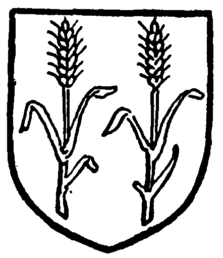
Bigland of Bigland. Azure two ears of big wheat in pale couped and bearded or.
But few notices of the township occur in the records. (fn. 16) The Park family had lands, (fn. 17) and Giles Park had his estate sequestered and then forfeited for his 'delinquency' in taking the side of the king in the Civil War. (fn. 18)
The Wesleyan Methodists have a church at Backbarrow.
A school at Browedge was built through a bequest by George Bigland in 1685.
