Survey of London: Volume 23, Lambeth: South Bank and Vauxhall. Originally published by London County Council, London, 1951.
This free content was digitised by double rekeying. All rights reserved.
'Albert Embankment', in Survey of London: Volume 23, Lambeth: South Bank and Vauxhall, ed. Howard Roberts, Walter H Godfrey( London, 1951), British History Online https://prod.british-history.ac.uk/survey-london/vol23/pp148-149 [accessed 23 November 2024].
'Albert Embankment', in Survey of London: Volume 23, Lambeth: South Bank and Vauxhall. Edited by Howard Roberts, Walter H Godfrey( London, 1951), British History Online, accessed November 23, 2024, https://prod.british-history.ac.uk/survey-london/vol23/pp148-149.
"Albert Embankment". Survey of London: Volume 23, Lambeth: South Bank and Vauxhall. Ed. Howard Roberts, Walter H Godfrey(London, 1951), , British History Online. Web. 23 November 2024. https://prod.british-history.ac.uk/survey-london/vol23/pp148-149.
In this section
CHAPTER 34 - THE ALBERT EMBANKMENT
[See plates 114, 118, 119, 121 and 122.]
The Victoria and the Albert Embankments were constructed at about the same time, but whereas the former ran down-stream from Westminster Bridge to the City, the latter was built up-stream from Westminster Bridge to Vauxhall. The decision as to the position of the embankment on the Surrey side was probably due to several factors; M.P.s wished to improve the view from the windows and terrace of the newly completed Palace of Westminster; old Lambeth, Fore Street, High Street, etc., were flooded whenever there was an exceptionally high tide, and there were various users anxious to take up the new river frontage once the land was reclaimed and embanked. At the northern end a considerable strip of ground was reclaimed, Lambeth Palace Road was constructed on the site of Stangate and Bishop's Walk, and St. Thomas' Hospital and the embankment walk were built on the old boat-building and barge house sites and on reclaimed land. South of Lambeth Bridge, Fore Street and many of the little courts and alleys opening out of it were swept away. At the southern end the Albert Embankment was merged into the street previously known as Vauxhall.
It was along the river strip between St. Mary's Church and Vauxhall that the population and industries of Lambeth were concentrated prior to the 19th century. Clay, charcoal and other materials for the potteries in Fore Street and High Street (formerly Back Lane) and for the Vauxhall glasshouse were brought by water and the finished products were transported in the same way. (fn. n1) To the north of Vauxhall Stairs (approximately where Vauxhall Walk now joins the Albert Embankment) was the house known originally as Copthall, and later, misleadingly, as Vauxhall (see p. 8). There Sir Thomas Parry lived in the time of James I, (fn. 1) and there the luckless Arabella Stuart was confined after her marriage to William Seymour. (fn. 3) It was in this house that the ingenious Marquess of Worcester and his assistant Caspar Kaltoff conducted their experiments, making guns, engines and other mechanical contrivances, (fn. 4) many of which, though they were not put to practical use, anticipated the inventions of the following century. The house remained standing until the beginning of the 19th century (Plate 120a).
The ground south of Vauxhall Stairs to Vauxhall Creek (see Plate 123) was part of the demesne land of Vauxhall Manor and belonged to the Dean and Chapter of Canterbury. Part of this ground was leased towards the end of the 17th century to Gerrard Weymans, (fn. 5) who had built “several mills for the cutting of Marble and a fair brick messuage and dwelling house there,” while on other parts of it were the barge houses of the Clothworkers', Mercers' and Fishmongers' Companies, several inns, the Feathers, the Royal Oak, etc., and the glasshouse of John Bellingham. (fn. 6)
In 1767 and 1777, Sir Joseph Mawbey obtained leases of the whole of this property from the Dean and Chapter, including what was described in 1777 as a messuage called the Vine, with three stables and a garden which had recently been made into a bowling green. (fn. 7) There he established a distillery which was subsequently taken over by Robert Burnett. When Vauxhall Bridge was built in 1809, the approach road from Kennington Lane was built across this property, the old Royal Oak Tavern being pulled down for the purpose. The Cumberland Tavern and Gardens, then a popular place of resort, lay to the south. (fn. 8) On the site of the old Vine Inn and close to the distillery, Sir Robert Burnett built a residence which was described in 1809 as “modern,” (fn. 6) and in 1823 as “replete with every Office and Convenience fitting for a genteel Family.” (fn. 6) The firm of Burnetts remained in possession until 1928, when it was taken over by the Distillers Company, Ltd. (fn. 2) The house, which is still standing, and is known as No. 85 Albert Embankment, is now owned and occupied by the Anglo-American Oil Company, Ltd.
Architectural Description
This is an asymmetrically grouped house of two and three storeys, built in yellow brick partly stuccoed with stone dressings. The main front faces northward and has bowed projections at either end. Its entrance has a stuccoed surround and a segmental patterned fanlight with a modelled female head to the keystone. There is paterae ornament with light pendant enrichment to each spandrel and an austere wood panelled porch set forward from the doorway. The elevation is unified by a deep band at first floor level, and there is a mutule cornice with blocking course to the parapet (Plate 118b).
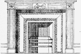
The room adjacent to the entrance has a small splayed bay window and contains a delicately detailed fireplace with reeded white marble surround and carved panels beneath a moulded shelf. The entrance hall has a mutule cornice and enriched ceiling rose, and above the spiral staircase the ceiling, pierced by an oval skylight with simple plaster relief, has a reeded cornice entwined with a foliated motif.

No. 85 Albert Embankment, fireplace. Measured drawing
