Ancient and Historical Monuments in the County of Gloucester Iron Age and Romano-British Monuments in the Gloucestershire Cotswolds. Originally published by Her Majesty's Stationery Office, London, 1976.
This free content was digitised by double rekeying. All rights reserved.
'Sodbury', in Ancient and Historical Monuments in the County of Gloucester Iron Age and Romano-British Monuments in the Gloucestershire Cotswolds(London, 1976), British History Online https://prod.british-history.ac.uk/rchme/ancient-glos/pp103-104 [accessed 25 February 2025].
'Sodbury', in Ancient and Historical Monuments in the County of Gloucester Iron Age and Romano-British Monuments in the Gloucestershire Cotswolds(London, 1976), British History Online, accessed February 25, 2025, https://prod.british-history.ac.uk/rchme/ancient-glos/pp103-104.
"Sodbury". Ancient and Historical Monuments in the County of Gloucester Iron Age and Romano-British Monuments in the Gloucestershire Cotswolds. (London, 1976), British History Online. Web. 25 February 2025. https://prod.british-history.ac.uk/rchme/ancient-glos/pp103-104.
SODBURY
(23 miles S.W. of Cirencester)
An uninscribed early Gallo-Belgic gold coin (fn. 1) and a group of Romano-British finds (fn. 2) are recorded from the vicinity of Chipping Sodbury (ST 7282).
Crop-marks photographed in 1969 at ST 769805 (Plate 59) suggest a roughly rectangular ditched enclosure of about 3 acres, facing S.S.E. at 600 ft. above O.D. (C.U.A.P., OAP AYG 27).
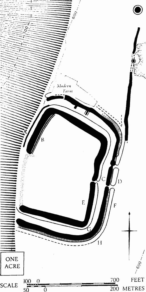
(1) Sodbury Camp (ST 760826), hill-fort, unexcavated, comprises two wide-spaced ramparts enclosing an inner area of 11 acres on the plateau edge, ½ mile S.E. of Little Sodbury village, its N. half lying within that parish (area map s.v. Horton, p. 66). All interior areas have been ploughed in the past (Plate 34). Plan and profiles, p. 104.
The inner rampart is set along the edges of a slight eminence on the N., E. and S., where it is about 35 ft. wide and rises 7 ft. above the interior; along the scarp edge on the N.W. it is lower. The ditch, 30 ft. wide and 7 ft. deep on the plateau, drops round the N. corner to follow, for some 400 ft., a natural terrace 25 ft. below the scarp edge. A low counter-scarp bank accompanies the ditch from the point where it drops to the terrace. At the entrance, in the middle of the E. side, the slightly staggered ends of the rampart contain much fire-reddened limestone. The surface of the causeway across the ditch is somewhat sunken.
The outer rampart, set 50 ft. beyond the inner ditch, terminates to N. and S. at the escarpment edge. Irregularly constructed and apparently unfinished, it is 56 ft. wide and up to 11 ft. high, with a berm 12 ft. wide. The ditch, 45 ft. wide, is 6 ft. to 10 ft. deep in the middle of the E. side; elsewhere the depth is 3 ft. or less. The entrance is opposite that through the inner defences. A second causeway in the ditch, 170 ft. to N., corresponds with a reduction in rampart size.
There are other earthworks immediately adjacent to the hill-fort. A linear bank is possibly contemporary and for this reason is described here, although it lies within the parish of Little Sodbury. The linear bank, 1,000 ft. long, 45 ft. wide and 2 ft. 6 in. high, with a ditch 28 ft. wide on its inner (W.) side, is possibly an addition to the hill-fort and continues the line of the E. defences northwards. At its S. end the bank runs for about 100 ft. along the outer edge of the ditch of the hill-fort. An embanked circle 22 ft. in diameter, possibly a tree-ring, stands on the bank 300 ft. from its N. end; about 145 ft. N. of the end is a second circle of similar character, 80 ft. in diameter. A plan by Witts (TBGAS, VIII (1883–4), 74–8, Pl. iii) shows the linear bank continuing beneath the second circle and thence, after a gap of 100 yds., W. to the escarpment edge. This continuation cannot now be traced. The alleged western end is a bank of mediaeval or later character with ditches on either side; it is one of a series which occurs N. of Little Sodbury Manor House. The long mounds described by Witts (ST 761829) are pillow mounds.
Banks within the hill-fort are as follows—(i) A low, flat-topped bank is built along the inner side of the inner rampart on the N.W., with a slight internal ditch. (ii) Two low parallel banks extend from the outer rampart towards the inner ditch on the N. (iii) Traces of a bank cross the interior, on the line of the parish boundary (map, p. 66).
Part of the rubber of a saddle-quern was found inside the hill-fort in 1958 (Gloucester City Museum records), and eight Roman coins ranging from Gallienus to Constantius II have been found within and in the vicinity of the hill-fort (Gloucester City Museum); the find-spots of three are marked on a plan in TBGAS, LII (1930), facing p. 184.

Sodbury. (1) Sodbury Camp Hill-fort. Plan.
Lloyd Baker (1821), 165, No. 11. Playne (1876), 219, No. 41. Witts (1883), 46, No. 92.
