Ancient and Historical Monuments in the County of Gloucester Iron Age and Romano-British Monuments in the Gloucestershire Cotswolds. Originally published by Her Majesty's Stationery Office, London, 1976.
This free content was digitised by double rekeying. All rights reserved.
'Siddington', in Ancient and Historical Monuments in the County of Gloucester Iron Age and Romano-British Monuments in the Gloucestershire Cotswolds(London, 1976), British History Online https://prod.british-history.ac.uk/rchme/ancient-glos/pp101-103 [accessed 25 February 2025].
'Siddington', in Ancient and Historical Monuments in the County of Gloucester Iron Age and Romano-British Monuments in the Gloucestershire Cotswolds(London, 1976), British History Online, accessed February 25, 2025, https://prod.british-history.ac.uk/rchme/ancient-glos/pp101-103.
"Siddington". Ancient and Historical Monuments in the County of Gloucester Iron Age and Romano-British Monuments in the Gloucestershire Cotswolds. (London, 1976), British History Online. Web. 25 February 2025. https://prod.british-history.ac.uk/rchme/ancient-glos/pp101-103.
SIDDINGTON
(adjacent to Cirencester on S.E.)
Ermin Street forms the N.E. boundary of the parish. An altar inscribed, but without a clear ascription, unprovenanced, was found in 1887. (fn. 1)
(1) Romano-British Settlement (SU 017997), mainly in the adjoining parish, is described s.v. Cirencester (3).
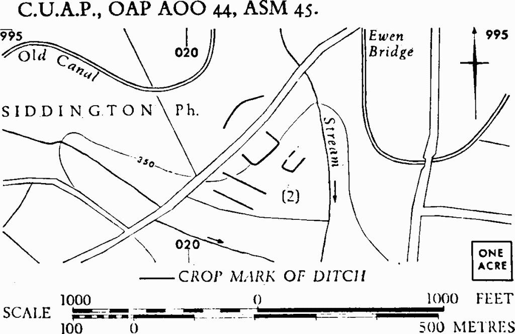
(2) Enclosures (SU 021993), undated, S.W. of Ewen Bridge, are partly visible as crop-marks on level ground. The S.E. side of the larger enclosure is about 180 ft. long.
C.U.A.P., OAP AOO 44, ASM 45.

Siddington. (2) Enclosures.
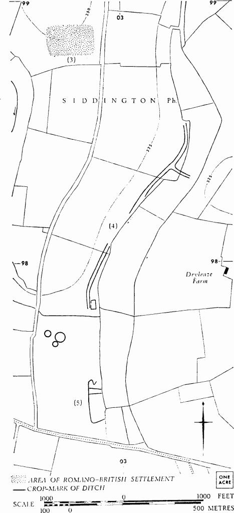
(3) Romano-British Settlement (SU 028988), ploughed out, S. of Clark's Lane, identified by Mr. R. Reece, is marked by concentrations of building debris and pottery covering an area of about 5½ acres on a low limestone ridge between two brooks. A well, discovered accidentally in 1966, remains unexcavated. Finds include a coin of Constantius II, pottery ranging from the late 1st to the 3rd or 4th century, and a white tessera.

Siddington. (3)–(5) Romano-British Settlement, Trackway and Enclosures.
(4) Enclosure and Trackway (SU 031984), the latter of a width to suggest a drove, undated, W. of Dryleaze Farm, show as crop-marks along the bottom of a shallow valley beside a brook.
The enclosure (su 02899785) at the S. end of the trackway measures about 60 ft. by 110 ft. and has a gap in the W. side. The trackway is defined by ditches about 40 ft. apart and can be traced N.E., with one interruption, for 900 yds. A narrower spur forks E. near the N. end.
N.M.R., OAP SU 0398/2/372–6.
(5) Enclosure (SU 028975), undated, is partly visible as a crop-mark 300 yds. S. of (4); the W. side is about 500 ft. long and there are internal subdivisions.
N.M.R., OAP SU 0297/7/381.
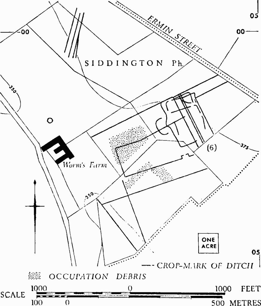
(6) Romano-British Settlement (SU 047997), on Worm's Farm adjacent to Ermin Street, ploughed out, shows in the form of crop-marks over some 30 acres and as a spread of occupation debris on a more limited area. The N. part of the settlement is on level ground, the rest lies on a slope facing south.

Siddington. (6) Romano-British Settlement.
Finds during investigation comprise a single sherd from a situlate vessel of Iron Age type and Romano-British pottery of 2nd-4th-century date, together with tegula and imbrex fragments. The finds are in Gloucester City Museum. The crop-marks suggest reorganization of boundaries within the settlement. Linear ditches 300 yds. to the N. (SU 044000) are undated.
C.U.A.P., OAP AOR 98, ASM 51–2, 55, AXO 93.
(7) Probable Settlement (SU 021984), undated, S.W. of Sandy Lane Farm, is faintly indicated by crop-marks over an area of about 3 acres.
C.U.A.P., OAP AZN 43.
(8) Rectilinear Ditches (SU 02939932), undated, N.W. of The Quarries, defining three parallel strips each about 70 ft. across, are visible as crop-marks.
N.M.R., OAP SU 0299/1/377.
