Ancient and Historical Monuments in the County of Gloucester Iron Age and Romano-British Monuments in the Gloucestershire Cotswolds. Originally published by Her Majesty's Stationery Office, London, 1976.
This free content was digitised by double rekeying. All rights reserved.
'Shipton', in Ancient and Historical Monuments in the County of Gloucester Iron Age and Romano-British Monuments in the Gloucestershire Cotswolds(London, 1976), British History Online https://prod.british-history.ac.uk/rchme/ancient-glos/p101 [accessed 25 February 2025].
'Shipton', in Ancient and Historical Monuments in the County of Gloucester Iron Age and Romano-British Monuments in the Gloucestershire Cotswolds(London, 1976), British History Online, accessed February 25, 2025, https://prod.british-history.ac.uk/rchme/ancient-glos/p101.
"Shipton". Ancient and Historical Monuments in the County of Gloucester Iron Age and Romano-British Monuments in the Gloucestershire Cotswolds. (London, 1976), British History Online. Web. 25 February 2025. https://prod.british-history.ac.uk/rchme/ancient-glos/p101.
SHIPTON
(10 miles N. of Cirencester)
A potin ('speculum') coin of the Iron Age has been found in the parish (Bagendon, 133).
(1) Romano-British Settlement (SP 03171923), identified by Sgt. B. Beveridge 700 yds. S.E. of the major Roman settlement of Wycomb (Whittington (2)), lies in a shallow dry valley nearly 600 ft. above O.D. The site is crossed by a modern drystone wall incorporating reused stone and it is also marked by scattered blocks of Oolite, squared sandstone, much pottery and some animal bones; one clay slingstone was found. Large numbers of worked flints have been found here. Finds are in private possession.
A few Romano-British sherds and oyster shells are scattered near the N. shoulder of the valley, 200 yds. to the north-west.
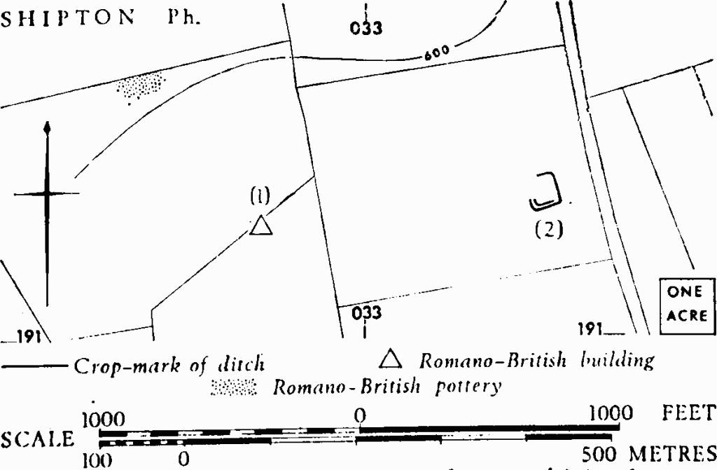
Shipton. (1) Romano-British Settlement. (2) Enclosure.
(2) Enclosure (SP 035193), undated, is suggested by crop-marks, 300 yds. E. of (1) on the N. slope of the same valley, bounding an area of perhaps 3/5 acre. Three visible angles are rounded. The S. and W. sides are defined by parallel ditches.
C.U.A.P., OAP ASB 18, 23.
(3) Enclosure (SP 06661943), 'Salperton Camp' (1883) or 'Penhill Camp' (1952), undated, occupies the summit of a ridge above the 800-ft. contour and has been claimed as Roman. It was perhaps trapezoidal in shape, about 240 ft. by 175 ft. Only the N. side remains undisturbed. At N.W. it consists of a bank up to 4 ft. high above an external ditch, returning S. for some feet. Other remains on the W. are obscured by a copse in a ditched enclosure and elsewhere the earthwork has been degraded by ploughing. The S. side is continuous with a ditch to the W. and with a bank to the E., both extending its alignment.
Witts (1883), 44–5, No. 89. Burrow (1924), 132. Arch J, CIX (1952), 23–4.