Ancient and Historical Monuments in the County of Gloucester Iron Age and Romano-British Monuments in the Gloucestershire Cotswolds. Originally published by Her Majesty's Stationery Office, London, 1976.
This free content was digitised by double rekeying. All rights reserved.
'Sherborne', in Ancient and Historical Monuments in the County of Gloucester Iron Age and Romano-British Monuments in the Gloucestershire Cotswolds(London, 1976), British History Online https://prod.british-history.ac.uk/rchme/ancient-glos/pp100-101 [accessed 25 February 2025].
'Sherborne', in Ancient and Historical Monuments in the County of Gloucester Iron Age and Romano-British Monuments in the Gloucestershire Cotswolds(London, 1976), British History Online, accessed February 25, 2025, https://prod.british-history.ac.uk/rchme/ancient-glos/pp100-101.
"Sherborne". Ancient and Historical Monuments in the County of Gloucester Iron Age and Romano-British Monuments in the Gloucestershire Cotswolds. (London, 1976), British History Online. Web. 25 February 2025. https://prod.british-history.ac.uk/rchme/ancient-glos/pp100-101.
SHERBORNE
(12 miles N.E. of Cirencester)
Nine Dobunnic gold coins (seven ANTED, one EISU and one CATTI) were found 'at or near Sherborne, Gloucestershire, about 1903'. (fn. 1)

Sherborne. (1) Romano-British Settlement.
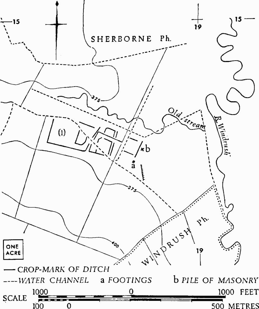
(1) Romano-British Settlement (SP 18821456), covering some 10 acres on an almost flat gravel terrace, shows as crop-marks within which there is evidence of stone-footed buildings. The terrace lies immediately S. of the former line of the old Sherborne stream, now drained by water channels which partly traverse the settlement. Before modern ploughing, much of the area was under ridge-and-furrow.
A short length of wall-footing, ending against a stone base for a rectangular wooden shaft, has recently been uncovered immediately under the humus at 'a'. It lies within a slightly raised area defined on the E. by a spread scarp, 1½ ft. high, with remains of Oolite walling scattered along it for 230 ft. A pile of building stone stood some 60 yds. N.N.E., outside this area, at 'b'. A light scatter of Romano-British pottery has been noted over the whole area of the crop-marks, with occasional small concentrations of building debris towards the W. end. The settlement extended for some 30 yds. S. of the water channel on the S. of 'a', apparently ending at the foot of the gentle rise southwards.
N.M.R., OAP (Baker) SP 1814/1–5.
