Ancient and Historical Monuments in the County of Gloucester Iron Age and Romano-British Monuments in the Gloucestershire Cotswolds. Originally published by Her Majesty's Stationery Office, London, 1976.
This free content was digitised by double rekeying. All rights reserved.
'Great Rissington', in Ancient and Historical Monuments in the County of Gloucester Iron Age and Romano-British Monuments in the Gloucestershire Cotswolds( London, 1976), British History Online https://prod.british-history.ac.uk/rchme/ancient-glos/pp59-60 [accessed 23 November 2024].
'Great Rissington', in Ancient and Historical Monuments in the County of Gloucester Iron Age and Romano-British Monuments in the Gloucestershire Cotswolds( London, 1976), British History Online, accessed November 23, 2024, https://prod.british-history.ac.uk/rchme/ancient-glos/pp59-60.
"Great Rissington". Ancient and Historical Monuments in the County of Gloucester Iron Age and Romano-British Monuments in the Gloucestershire Cotswolds. (London, 1976), , British History Online. Web. 23 November 2024. https://prod.british-history.ac.uk/rchme/ancient-glos/pp59-60.
GREAT RISSINGTON
(15 miles N.E. of Cirencester)
A scatter of many Romano-British potsherds was noted during airfield construction. (fn. 1)
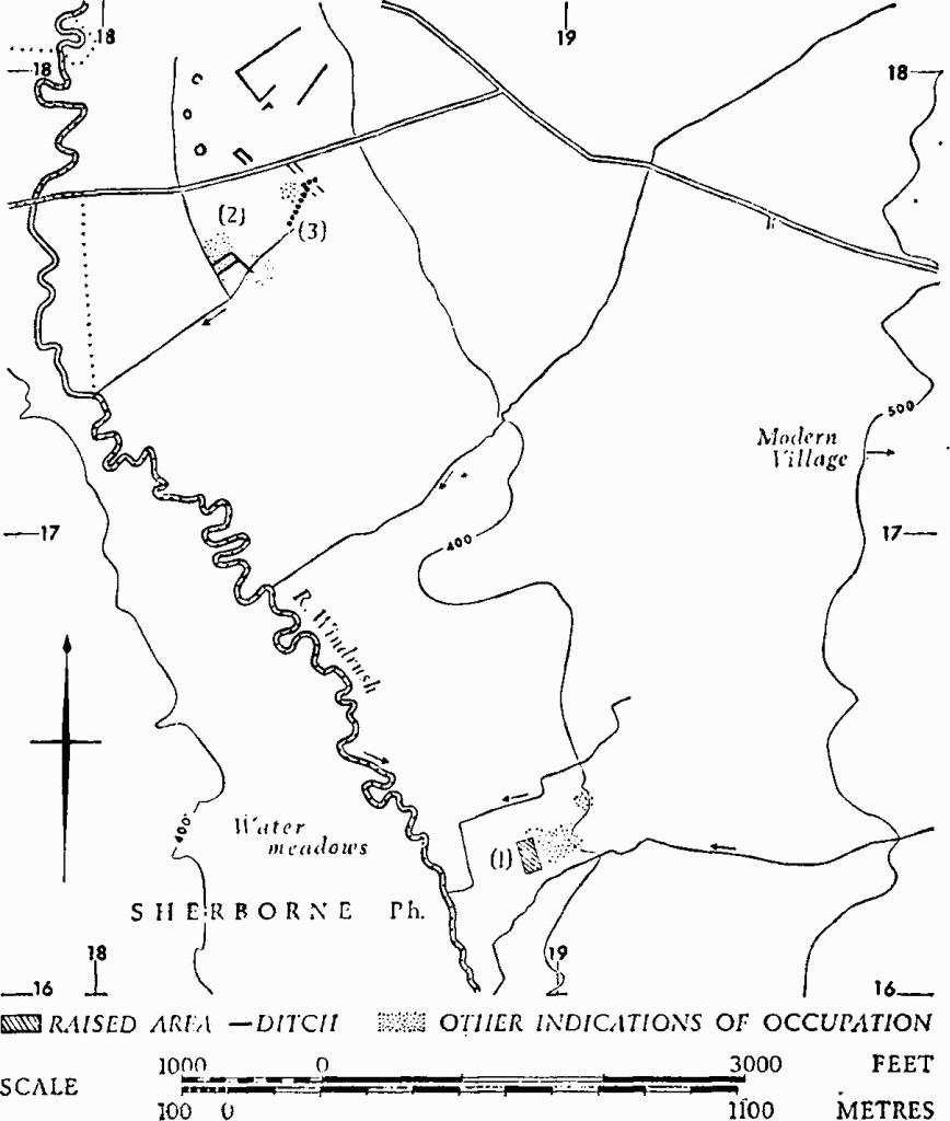
(1) Roman Villa (SP 189163), in a field named 'Chessels' which formerly was covered by broad plough-ridges, but now is almost levelled by modern ploughing, stands at the edge of the Middle Lias and some 8 ft. above the level of streams which flank it to N. and S.; these flow into the R. Windrush, 200 yds. to the west. The villa is partly marked by a roughly rectangular platform with rounded edges, approximately 240 ft. long by 80 ft. wide and up to 4 ft. high. Building stone lies scattered on it, and concentrations of nettles extend from it eastwards for some 450 ft. on a natural shelf, beyond which the ground rises gently.

Monuments in Great Rissington.
Surface finds, in private possession, include hypocaust and roofing tiles, sandstone roof-slates, fine and coarse tesserae (some in concentrations), opus signinum, and pottery ranging from late 1st-century and 2nd-century samian ware to 3rd and 4th-century types, including Oxfordshire rosette-stamped colour-coated ware. Iron slag was also found.
R.A.F., VAP CPE/UK 2013: 4179–80.
TBGAS, 82 (1968), 204.
Note: Monument (2) is a complex of many different features, some of them probably related to the adjacent pit-alignment (3). The latter is listed separately because of its rarity in the Cotswold area.
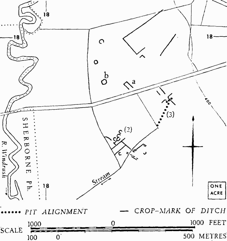
(2) Probable Settlement (SP 183177), probably Iron Age and Romano-British, shows as crop-marks on almost flat low-lying ground, drained by canalised streams which flow S.W. past the crop-marks into the R. Windrush, some ¼ mile away. A group of at least four penannular features (18271762), from 30 ft. to 40 ft. across, with entrances on the E. and S.E., possibly hut-circles, lies immediately N. of a pattern of linked rectangular enclosures. To the S. are traces of parallel ditches, and possibly of trackways and pits. About 80 yds. N.E. of the area described, a pit-alignment (3) extends N.E. for at least 100 yds., intersecting other linear features. There are further suggestions of occupation in this area, as well as linear ditches. In the field N. of the modern road is an incomplete rectangular enclosure (a), about 40 ft. wide and perhaps 100 ft. long. Another enclosure (b) is irregular and about 70 ft. across, with two straight and possibly three curved sides. A circular ditch about 35 ft. across, 80 yds. N. of (b), could represent a barrow. Another circle about the same distance further N., some 45 ft. in diameter, has suggestions of an entrance in the S.E. Long straight ditches to the E. of these circles correspond approximately in alignment with the linear features around (3). There are faint indications of further linear ditches on these axes and of very small rectangular enclosures, all undated, some 300 yds. further N., centred at SP 18301833.
N.M.R., OAP (Baker), SP 1817/1–6; 1818/1.

Great Rissington. (2) Probable Settlement. (3) Pitalignment.
(3) Pit-alignment (SP 18411768), extends N.N.E. for at least 100 yds. across almost flat ground, now arable (see (2)).
