Ancient and Historical Monuments in the County of Gloucester Iron Age and Romano-British Monuments in the Gloucestershire Cotswolds. Originally published by Her Majesty's Stationery Office, London, 1976.
This free content was digitised by double rekeying. All rights reserved.
'Duntisbourne Abbots', in Ancient and Historical Monuments in the County of Gloucester Iron Age and Romano-British Monuments in the Gloucestershire Cotswolds( London, 1976), British History Online https://prod.british-history.ac.uk/rchme/ancient-glos/p48 [accessed 23 November 2024].
'Duntisbourne Abbots', in Ancient and Historical Monuments in the County of Gloucester Iron Age and Romano-British Monuments in the Gloucestershire Cotswolds( London, 1976), British History Online, accessed November 23, 2024, https://prod.british-history.ac.uk/rchme/ancient-glos/p48.
"Duntisbourne Abbots". Ancient and Historical Monuments in the County of Gloucester Iron Age and Romano-British Monuments in the Gloucestershire Cotswolds. (London, 1976), , British History Online. Web. 23 November 2024. https://prod.british-history.ac.uk/rchme/ancient-glos/p48.
DUNTISBOURNE ABBOTS
(5 miles N.W. of Cirencester)
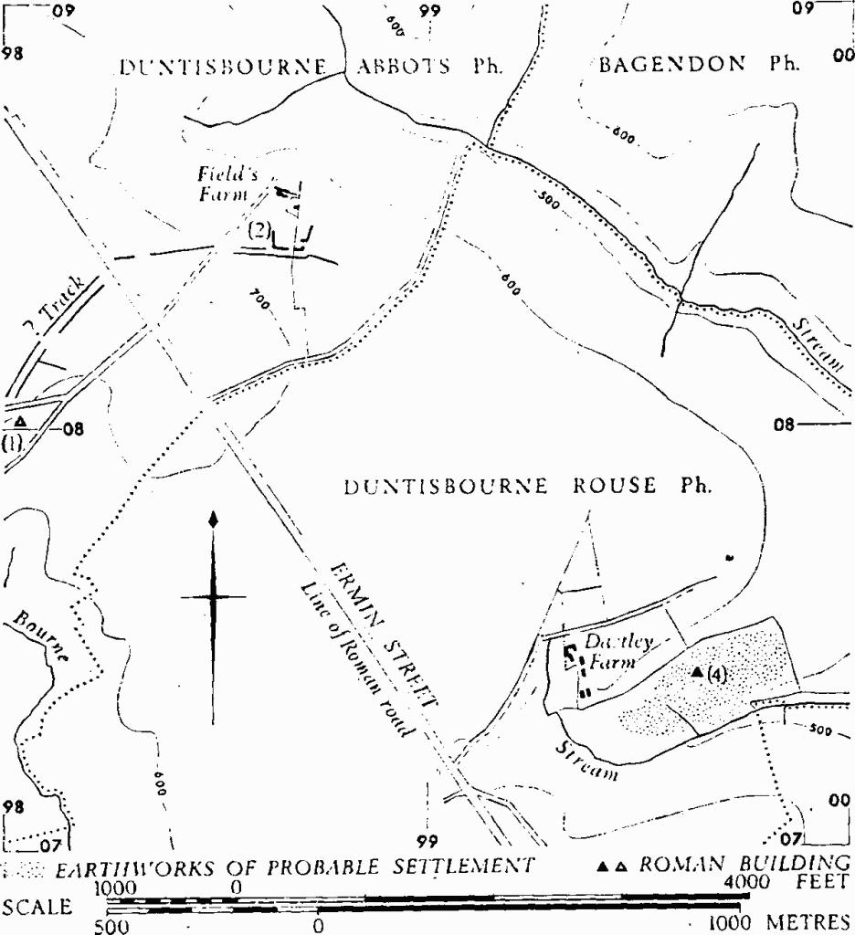
The two sites described below may have been linked by broad, ditched tracks, seen as crop-marks on air photographs (fn. 1) (Plates 62–3), almost meeting at Ermin Street (see plan below).
A native butt-beaker and a cooking-pot, found by workmen, are imprecisely located. (fn. 2)

Monuments in Duntisbourne Abbots and Duntisbourne Rouse.
(1) Romano-British Building (about so 981081), situated on a nearly level shoulder of ground above the stream at Duntisbourne Leer, but no longer to be located precisely, was uncovered in 1924 in a single day's excavation. Walls and concrete floor lay in a field with Romano-British debris, including 3rd and 4th-century coins. A stone some 7 ft. long with a single long groove in it, from the same field, is now at Leer Farm.
TBGAS, XLV (1923), 295. JRS, XIV (1924), 231. Information from Mrs. H. R. Carver and Mr. P. D. C. Brown.
(2) Enclosure (SO 987085), probably Romano-British, S. of Field's Farm, is associated with a feature which appears to be a ditched track leading W. to Ermin Street (see above; also Plate 63). Only three sides of the enclosure are recognisable. On S. and E. faint traces of bank and external ditch survive; there was an entrance at the S.E. corner. Within the enclosure the land slopes down towards the N. at an inclination of up to 6°. Small abraded potsherds of Roman date, including samian, have been found on the surface.
