An Inventory of the Historical Monuments in Dorset, Volume 1, West. Originally published by Her Majesty's Stationery Office, London, 1952.
This free content was digitised by double rekeying. All rights reserved.
'Stratton', in An Inventory of the Historical Monuments in Dorset, Volume 1, West(London, 1952), British History Online https://prod.british-history.ac.uk/rchme/dorset/vol1/pp226-229 [accessed 30 January 2025].
'Stratton', in An Inventory of the Historical Monuments in Dorset, Volume 1, West(London, 1952), British History Online, accessed January 30, 2025, https://prod.british-history.ac.uk/rchme/dorset/vol1/pp226-229.
"Stratton". An Inventory of the Historical Monuments in Dorset, Volume 1, West. (London, 1952), British History Online. Web. 30 January 2025. https://prod.british-history.ac.uk/rchme/dorset/vol1/pp226-229.
In this section
86 STRATTON (E.d.)
(O.S. 6 in. XL, N.W.)
Stratton is a parish and small village 3½ m. N.W. of Dorchester. The Celtic settlement is the principal monument.
Ecclesiastical
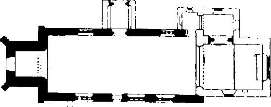
(1) Parish Church of St. Mary stands in the village. The walls are of local rubble with dressings of the same material; the roofs are covered with tiles, lead and stone slates. The Nave was built probably in the 12th century. The West Tower was added early in the 15th century and the nave was extended to it and extensively rebuilt shortly after. The church was drastically restored in 1891 when the Chancel was rebuilt and the North Porch was largely rebuilt.
Architectural Description—The Chancel (20 ft. by 15½ ft.) is modern, but the N. wall incorporates the rough rear-arch of a doorway and further W. the re-erected late 12th-century chancel-arch; it is two-centred and of two continuous chamfered orders, with a chamfered and grooved label on the S. face.

The Church, Plan
The Nave (49½ ft. by 19½ ft.) has, in the N. wall, two 15th-century windows, the eastern partly restored and of three cinque-foiled lights in a square head with a moulded label and returned stops; the western is also partly restored and is of three cinque-foiled lights with vertical tracery in a two-centred head with moulded reveals and label with returned stops; at the E. end of the wall is a modern doorway; the partly restored and rebuilt late 12th-century N. doorway has jambs of two chamfered orders, a round outer order to the head and a four-centred head of the 15th century to the inner order. In the S. wall are three 15th-century windows, each of three trefoiled ogee lights with tracery in a two-centred head with moulded reveals and label with head-stops; the 12th-century S. doorway, now blocked, has chamfered jambs of two orders, a round head to the outer and a rebuilt segmental head to the inner order; the label is chamfered.
The West Tower (7¾ ft. by 8¾ ft.) is of early 15th-century date and of three stages, with an embattled parapet and gargoyles. The two-centred tower-arch is of two continuous hollow-chamfered orders, with a tas-de-charge of three courses. The W. window is of two trefoiled lights with a quatrefoil in a two-centred head with a label; the W. doorway has moulded jambs and two-centred arch. The second stage has, in the N. wall, a square-headed window. The bell-chamber has, in each wall, a window of two trefoiled lights in a square head with blind heads to the lights. The ground-stage has moulded ceiling-beams.
The North Porch has been rebuilt but incorporates old materials including the 14th or 15th-century outer archway with jambs and two-centred arch of two chamfered orders.
Fittings—Bells: five; 1st recast at the Closworth foundry, 1753; 2nd by Thomas Purdue, 1695; 3rd by Thomas Purdue, 1658; 4th by Roger Purdue, 1627; 5th by George Purdue, 1619. Churchyard Cross: N. of nave—octagonal to square base on two steps, 14th or 15th-century, stem modern. Font: circular convex bowl with plain band at top and filleted under edge, probably 13th-century, stem modern. Glass: In nave —in tracery of S.W. window, roses, crown, sun in wreath, initial M and fragments, 15th-century. Monuments and Floor-slabs. Monuments: In nave—on S. wall, (1) to Robert Pattison, 1845, and later inscription, white marble wall-tablet with urn and shield-of-arms. In churchyard—N. of tower, (2) table-tomb, sunk in ground, 15th or 16th-century. Floor-slabs: In nave— (1) to Katherine Fisher, widow, 1638; (2) to William Pyll, 1764, John, son of William Taunton, and Elizabeth his wife, 1769; (3) to Elizabeth, mother of William and Thomas Taunton, 1741, with hour-glass, cross-bones and cherub's head; (4) to Mary, wife of Thomas Taunton, daughter of Morgan Devenish, 1742, and Thomas her son. Niches: In nave—in E. splays of first and second S. windows, with pinnacled and crocketed canopies, human head over eastern canopy, defaced bracket under eastern and bracket carved with half-angel holding shield under western, 15th-century. On N. porch—over outer archway, recess with chamfered jambs and two-centred head, mediæval, reset. Piscina: In vestry—in W. wall, round drain, reset. Plate: includes an Elizabethan cup with band of engraved ornament. Staircase: In tower—five-sided framed enclosure (Plate 205) of oak, filled in with large linen-fold panels and resting on moulded post (continued up as a newel) with a moulded base and capping from which springs ribbed vaulting of trumpet-form on the N. side with a moulded cornice, early 16th-century with modern repair. Miscellanea: In vestry— mutilated figure of woman, mediæval, brought from elsewhere. In second stage of tower, lead plate with the names of the churchwardens and the date 1703.
Secular
(2) Jackman's Cross, nearly 1½ m. N. of the church, consists now only of the square base-stand with a chamfered upper edge and a rectangular socket for the former shaft. It is of mediæval date.
(3) Manor Farm, house 40 yards S.W. of the church, is of two storeys with attics; the walls are of flint and rubble in bands and the roofs are tiled. The earliest part of the house is the S. end, which was later extended N., and later still the cross-wing at the N. end was added; all three parts fall within the 17th century. The E. front has a doorway with moulded jambs and four-centred head and a number of 17th-century stonemullioned windows. Inside the building, the S. room has a fireplace flanked by original fluted wooden side-pilasters supporting a frieze with arabesque ornament; the overmantel (Plate 47) is of two bays divided and flanked by terminal figures supporting a bracketed and enriched entablature; the bays have each an enriched panel with a cartouche. The next room has a fireplace with an early 18th-century stone surround and a dado of 17th-century panelling.

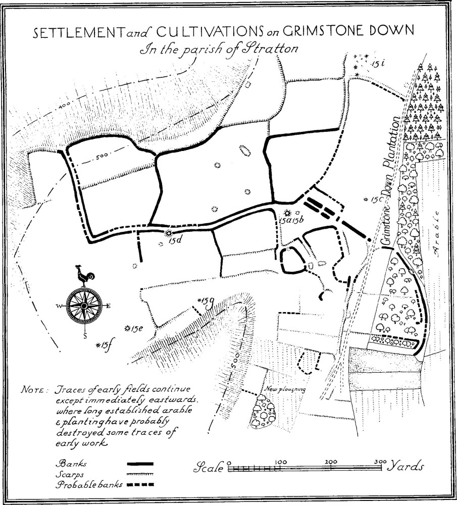
Settlement and Cultivations on Grimstone Down in the parish of Stratton
Monuments (4–10)
The following monuments, unless otherwise described, are of the 17th century and of two storeys; the walls are of local rubble and the roofs are thatched or covered with modern materials. Some of the buildings have exposed ceiling-beams and original fireplaces.
(4) Church Farm, cottage 100 yards E. of the church.
(5) Cottage, immediately N. of (4).
(6) Cottage, on the S. side of the road, 500 yards E.S.E. of the church.
(7) Cottage, opposite (6), retains an original muntin and plank partition.
(8) High Wrackleford, house ¾ m. E.S.E. of the church, has later extensions on the W. and has rubble and cob walls. The Barn, E. of the house, has been re-roofed.
(9) Cottage, two tenements, on the N.E. side of the road at Grimstone, ¾ m. W.N.W. of the church.
(10) House, 90 yards N.N.W. of (9), retains an original three-light window at the back with an oak frame bearing the date 1639; there is a similar window below.
Earthworks
(11) Celtic Settlement, on Grimstone Down in the N. part of the parish, consists of traces of Celtic fields covering more than 100 acres. They extend to the edge of the parish on the N., on the S. to the southern of Grimstone Clumps, on the E. into Grim-stone Coppice and on the W. to near Langford Gate. Towards the middle of the area the fields become more clearly defined and between the field-banks several hollowed tracks converge on a series of smaller enclosures; these, though they show no traces of dwellings, no doubt represent the position of the main settlement. The smaller enclosures include a small rhomboidal one with an entrance on the W. and a possible entrance on the E. and a larger enclosure adjoining the smaller and having an entrance on the N.; the bank is turned inwards on either side of the entrance and there are traces of a hollowed track through the enclosure. The S. end of the group has been much destroyed but traces survive of a third small enclosure and about 100 yards to the S. of two small enclosures.
To the N. of Lawyer's Plantation, N.E. of Grimstone Down, is a dyke and beyond it to the E. are further remains of a Celtic field-system; this system extended some distance to the S. The dyke, above mentioned, extends across the ridge and the ditch at its best preserved point is 13 ft. wide and 1¾ ft. deep; there are remains of a bank on the S.W. about 11 ft. wide and 1 ft. high and traces also of a bank to the N.E. which, however, appears to be no part of the original work.
(12) Bowl Barrow, near the N. edge of the parish, ¼ m. N.W. of Jackman's Cross (2), is 38 ft. in diam. and 3 ft. high.
(13) Bowl Barrow, 50 yards N.E. of Jackman's Cross, is 52 ft. in diam. and 5½ ft. high.
(14) Bowl Barrow, in Coronation Plantation on the N. edge of the parish, 350 yards N.E. of Jackman's Cross, is 42 ft. in diam. and 4½ ft. high. It has been disturbed in the middle.
(15) Bowl Barrows, on Grimstone Down, are eight in number. The first (a), 540 yards S.S.W. of Jackman's Cross and 220 yards W. of Grimstone Down Plantation, is 50 ft. in diam. and 5 ft. high; it has been disturbed in the middle. (b), 20 yards E. of (a), is 36 ft. in diam. and now 1½ ft. high, it has been much disturbed in the middle. (c), 155 yards E. by N. of (a), is 27 ft. in diam. and 2½ ft. high, it has been disturbed. (d), 240 yards W. by S. of (a), is 45 ft. in diam. and 5 ft. high. (e), 390 yards S.W. of (a), is 35 ft. in diam. and 2½ ft. high. (f), 68 yards W.S.W. of (e), is 22 ft. in diam. and 2½ ft. high. (g), 150 yards E.N.E. of (e), is 18 ft. in diam. and 3 ft. high. (h), in the southern of the Grimstone Clumps, is about 52 ft. in diam. and 5 ft. high. (i) an area about 320 yards N.N.E. of (a) contains a number of slight mounds possibly the remains of barrows now too indefinite for measurement.
(16) Bowl Barrow, on Hog Hill, 160 yards S.W. of the S. end of Stratton Down Plantation, is approximately 30 ft. in diam. and 3½ ft. high.
(17) Bowl Barrow, on Stratton Down near the E. edge of the parish and 720 yards S.E. of Jackman's Cross, is 30 ft. in diam. and 2½ ft. high. It has been disturbed in the middle.
(18) Lynchets, on a W. slope E. and S.E. of Newlands Plantation, ½ m. N.E. of the church, consist of seven terraces.
