An Inventory of the Historical Monuments in Dorset, Volume 1, West. Originally published by Her Majesty's Stationery Office, London, 1952.
This free content was digitised by double rekeying. All rights reserved.
'Poorton, North', in An Inventory of the Historical Monuments in Dorset, Volume 1, West( London, 1952), British History Online https://prod.british-history.ac.uk/rchme/dorset/vol1/pp180-181 [accessed 27 November 2024].
'Poorton, North', in An Inventory of the Historical Monuments in Dorset, Volume 1, West( London, 1952), British History Online, accessed November 27, 2024, https://prod.british-history.ac.uk/rchme/dorset/vol1/pp180-181.
"Poorton, North". An Inventory of the Historical Monuments in Dorset, Volume 1, West. (London, 1952), , British History Online. Web. 27 November 2024. https://prod.british-history.ac.uk/rchme/dorset/vol1/pp180-181.
In this section
73 POORTON, NORTH (C.d.)
(O.S. 6 in. XXIX, S.E.)
North Poorton is a small parish 3 m. S.E. of Beaminster. The camp is the principal monument.
Ecclesiastical
(1) Old Parish Church of St. Peter, 50 yards N. of the modern church, was a building of local rubble. The walls generally stand to a height of 4 ft. but in the N. wall is a doorway with moulded jambs and four-centred head of the 15th or 16th century. The church formed a plain rectangle, about 42 ft. by 15 ft. externally. The modern church was built in 1861; there is a Bell here by R.P., 1635, and the following Monuments are in the S. Vestry, (1) to John Paul, 1737, slab; (2) to John Mordon, 1717, slab; (3) to Mabel, wife of Thomas Paul, 1727, slab; (4) to Thomas Paul, 1719, slab; (5) to John Cox Russell, rector, 1819, oval marble wall-tablet; (6) to Thomas Paul, 1719, tablet lying loose.
Secular
(2) North Poorton Farm, house 200 yards N.N.E. of the church, is of two storeys with attics; the walls are of rubble and the roofs are thatched. It was built in the 17th century and the S. wing was added probably early in the 18th century. The building retains some original stone-mullioned windows with labels; the later S. wing has two doorways one with a four-centred and one with a square head; above the former and flanking the latter are oval windows; some early 18th-century windows of normal form, with labels, also remain.
(3) Cottage, 30 yards N. of (2), is of two storeys; the walls are of rubble and the roofs are thatched. It was built in the 17th century and has a doorway with a four-centred head.
(4) Cottage, 300 yards E.S.E. of the church, is of two storeys; the walls are of rubble and the roofs are thatched. It was built probably early in the 18th century.
Earthworks
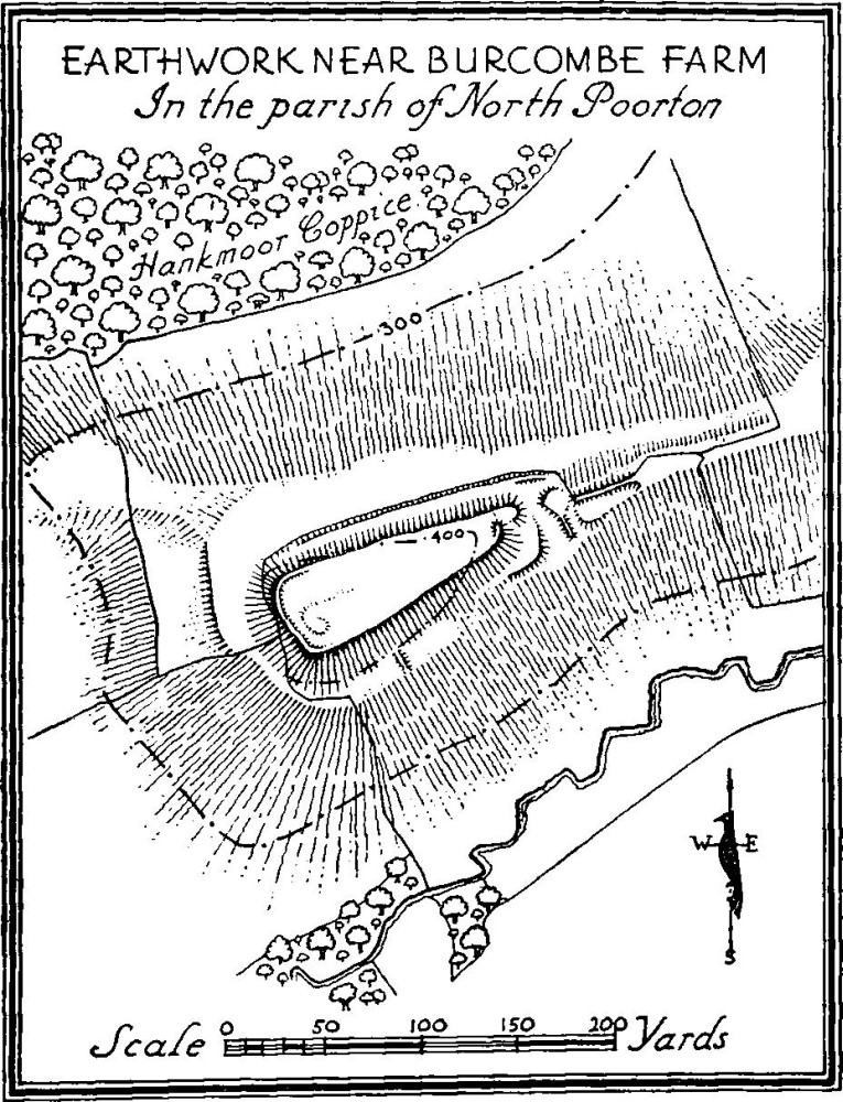
(5) Hill Fort lies on the end of a ridge (415 ft. above O.D.), over ½ m. N.W. of the church. The ground falls steeply to the S. and W., less steeply to the N. and is nearly level towards the E. The internal area is about 1 acre and the total area including the defences about 2½ acres.

Earthwork Near Burcombe Farm in the Parish of North Poorton
The site consists of a triangular-shaped spur connected at its narrow end to the main hill side. The defences are simple, consisting of a transverse ditch across the narrow end, and the artificial steepening of the remaining three sides of the spur at a level of some 12–20 ft. below the top of the spur and the consequent formation of a berm at that level. As the N. slope of the hill is not so rapid as that on the S. the artificially steepened scarp is of no great height. If there was ever a ditch in what is now the berm, on that side, it could have been of no great size and is now entirely filled up. There are traces of a slight rampart along the top at the W. end of the enclosure and a short piece on the S., just short of the E. end where it is turned inwards on the west side of the entrance at that point.
Within the enclosure—which is pear-shaped on plan —are traces of a very irregularly shaped mound which may however be largely natural. Just beyond the transverse ditch on the E. is a short length of rampart along the crest of the narrow causeway-like end of the spur and immediately S. of the same is a roughly triangular berm which has a slight ditch at its W. end; the ditch so formed is divided from the main transverse ditch by a slight bank. On the berm on the S. side, where shown on plan, is a slight transverse bank of uncertain date.
Approaching the camp from Burcombe Farm along the top edge of the southern scarp of the hill side is a slight bank. The surface indications suggest that it may be of later date than the camp.
