An Inventory of the Historical Monuments in Dorset, Volume 1, West. Originally published by Her Majesty's Stationery Office, London, 1952.
This free content was digitised by double rekeying. All rights reserved.
'Kingstone Russell', in An Inventory of the Historical Monuments in Dorset, Volume 1, West(London, 1952), British History Online https://prod.british-history.ac.uk/rchme/dorset/vol1/pp127-129 [accessed 6 February 2025].
'Kingstone Russell', in An Inventory of the Historical Monuments in Dorset, Volume 1, West(London, 1952), British History Online, accessed February 6, 2025, https://prod.british-history.ac.uk/rchme/dorset/vol1/pp127-129.
"Kingstone Russell". An Inventory of the Historical Monuments in Dorset, Volume 1, West. (London, 1952), British History Online. Web. 6 February 2025. https://prod.british-history.ac.uk/rchme/dorset/vol1/pp127-129.
In this section
53 KINGSTON RUSSELL (D.e.)
Earthwork on Tenants Hill
(O.S. 6 in. (a)XXXIX, S.W. (b)XXXIX, S.E. (c)XLVI, N.W. (d)XLVI, N.E.)
Kingston Russell is a parish 7 m. W. of Dorchester. Kingston Russell House is the principal monument.
Secular
c(1) Kingston Russell House, on the W. edge of the parish, is of two storeys with cellars; the walls are faced with Portland stone and the roofs are lead-covered. The house stands on the site of and perhaps incorporates some of the walling of a 17th-century house and the E. front and gallery were built probably late in the 17th century; the wing formerly projecting at the N. end of this front was destroyed at some uncertain period. The house was remodelled early in the 18th century by John Michel (d. 1739) and to this period belongs the W. front. The extensions at the N. and S. ends are modern but that on the N. incorporates some 17th-century material. The W. front (Plate 117) is of early 18th-century date and of three main bays with a cornice and balustraded parapet; the central bay has four Ionic pilasters supporting an entablature and pediment; the central doorway has a bracketed pediment and is approached by a flight of steps. The windows in the central bay are round-headed but the others have segmental heads and architraves. The E. front (Plate 117) has a string between the storeys and a cornice and parapet continued from the W. front. The two storeys have tall double-transomed windows of late 17th-century date; the doorway has an architrave and broken scrolled pediment resting on brackets. Inside the building, the Entrance Hall has early 18th-century plaster panelling and cornice; the fireplace has a heavy stone architrave and overmantel with scrolls and cornice. The N. Dining Room is lined with bolection-moulded panelling of the same period. The S. room also has 18th-century panelling and an enriched plaster ceiling with a foliage wreath in the middle and a band of conventional enrichment outside it. The early 18th-century staircase (Plate 53) has twisted balusters and fluted columns for newels, over which the rail is ramped.
d(2) Pitcombe Dairy, house 5/8 m. E. of Kingston Russell House, has walls of rubble plastered over and tile-covered roofs. It was built in the 17th century and retains some original two-light stone-mullioned windows.
Earthworks
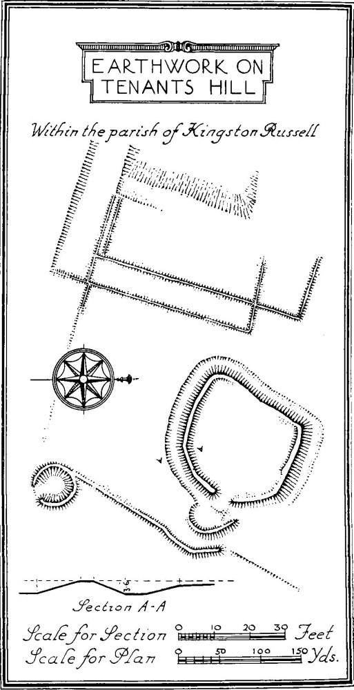
c(3) Settlement on Tenants Hill (600 ft. above O.D.) in the S. angle of the parish, consists of a roughly oval enclosure of about ⅓ of an acre, surrounded by a bank and ditch; the bank is about 3½ ft. high. There is an entrance on the E.S.E. with a slight causeway across the ditch; beyond this are faint traces of a traverse-like semi-circular bank. There are no traces of works in the main enclosure except for a slight sinking on the S.W. Immediately E. of the semi-circular bank is a second bank running N.E. and S.W. and at its S. end is a probable hut-circle. The settlement would appear to be akin to those associated elsewhere with Celtic field-systems, some cultivation scarps possibly of Celtic origin existing immediately W. of the enclosure.
Kingston Russell Stone Circle
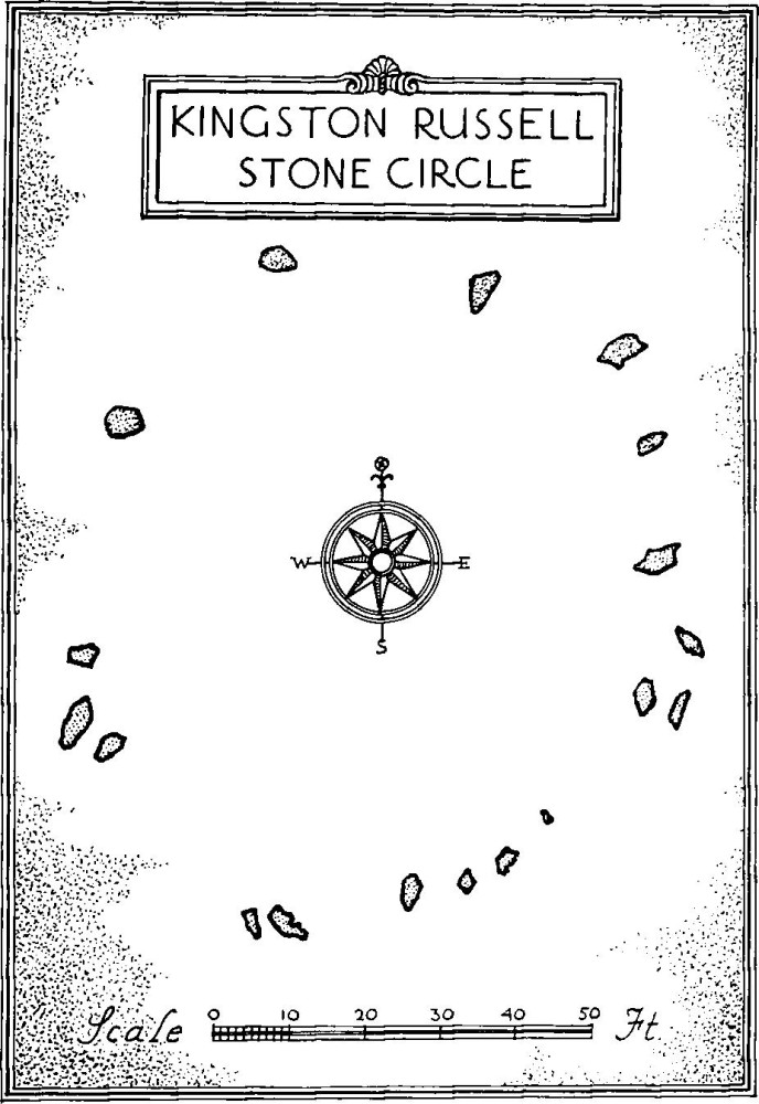
c(4) Stone Circle, on Tenants Hill in the extreme S. point of the parish, consists of fallen conglomerate stones forming an irregular oval 80 ft. by 91 ft. The largest stone is about 8 ft. long.
c(5) Mound and Barrow on Tenants Hill; the first, possibly the remains of a barrow, is 75 yards N.W. of (4) and is 50 ft. in diam. and ¾ ft. high. The bowl barrow, 600 yards further to the W.N.W., is 52 ft. in diam and 6 ft high; it has been disturbed in the middle.
Distribution Plan of Barrows on the West Part of Black Down
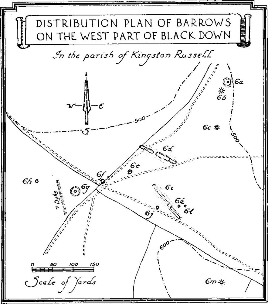
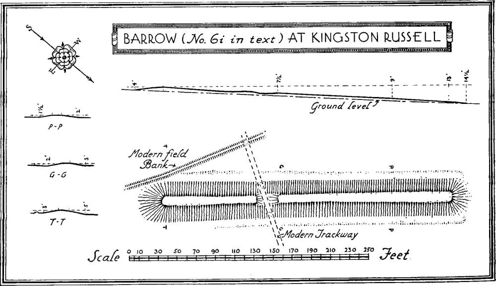
a and b(6) Group of Barrows between the 500 and 600 ft. contours on or near the top of a ridge to the W. of Black Down and ¾ m. N.E. of Kingston Russell House. The northernmost (a), a disc barrow, is 400 yards S. of the eighth milestone from Bridport on the main road. It is 73 ft. in diam. over all (for plan, see preface, p. xxxii); the bank and ditch are much worn down; the central mound is 13 ft. in diam. and 1 ft. high; (b) bowl barrow, 20 yards S. of (a), is 45 ft. in diam. and 4½ ft. high, with traces of a ditch; (c) bowl barrow, 95 yards S. of (b), is about 35 ft. in diam. and 1½ ft. high; (d) bank barrow, 150 yards S.W. of (c), is about 104 yards long (127½°) with a shallow ditch on each side. Near the E. end the barrow is 6 ft. high but it decreases in height towards the W. and there is a corresponding decrease in width from 45 ft. to 34 ft. The barrow has been much mutilated by gaps for tracks etc.; (e) bowl barrow, 250 yards W.S.W. of (c), is 50 ft. in diam. and 5 ft. high, with traces of a ditch; on the top is lying a rough conglomerate stone 7 ft. by 3¾ ft. by 2 ft.; (f) bowl barrow, 70 yards W.S.W. of (e), is 51 ft. in diam. and 5 ft. high; (g) disc barrow, 70 yards W.S.W. of (f), is 75 ft. in diam. over all (plan, see preface, p. xxxii); the central mound is 30 ft. in diam. and 2½ ft. high; the bank has been much worn down and there is no definite trace of a ditch; (h) bowl barrow, 100 yards W.N.W. of (g), is 34 ft. in diam. and 2 ft. high; it has been disturbed in the middle; (i) bank barrow (151½°), 70 yards S. of (d), is 347 ft. long with a ditch on both sides. The height varies from 5 ft. at the S.E. end to 1½ ft. at the N.W. end; the width varies correspondingly from 43 ft. to 38½ ft. The bank is cut across by a modern trackway (O.S. Map of Neolithic Wessex, No. 140); (j) mound, much disturbed but probably a bowl barrow, 110 yards S.E. of (e), is 35 ft. in diam. and 2½ ft. high; there is a wide sinking in the middle; (k) bowl barrow with a ditch, 50 yards E.N.E. of (j), is 25 ft. in diam. and 1¾ ft. high; (1) mound, probably a bowl barrow defaced, 15 yards E. of (k), is 21 ft. in diam. and ¾ ft. high; (m) mound, probably the remains of a barrow, 200 yards S.S.E. of (1), is about 45 ft. in diam. and 1½ ft. high; it is under the plough.
Barrow (No. 6i in text) at Kingston Russell
b(7) Barrows etc. (Plate 106), between the 400 ft. and 500 ft. contours on the E. part of Black Down and on the E. side of the parish, are twenty in number: (a) bowl barrow with a ditch, 825 yards S.E. of Kingston Russell Farm and 150 yards S. of the main road, is 51 ft. in diam. and 4½ ft. high; (b) bowl barrow, immediately N.E. of (a), is 27 ft. in diam. and 1½ ft. high; it fills the ditch of (a) on the N.E. side; (c), 155 yards E.N.E. of (b), is 45 ft. in diam. and 4 ft. high; (d), immediately E. of (c), is 50 ft. in diam. and 4½ ft. high; there are possible traces of a continuous ditch on the N. side, common to this and (c); (e) bowl barrow, 25 yards E. of (d), is 78 ft. in diam. and 9 ft. high with a ditch 12 ft. wide; (f) bowl barrow, 20 yards S.E. of (e), is 43 ft. in diam. and 4 ft. high; (g) mound, possibly the remains of a bowl barrow, 22 yards E.N.E. of (f), is about 24 ft. in diam. and 1½ ft. high; (h) bowl barrow, 30 yards E.S.E. of (f), is 47 ft. in diam. and 4 ft. high; (i) bowl barrow, 60 yards N.N.E. of (h), is about 38 ft. in diam. and 3½ ft. high; (j) probable disc barrow, 37 yards E. of (h), is about 104 ft. in diam. over all (for plan, see preface, p. xxxii), inclusive of an outer ditch approximately 12 ft. in width; the bank is 18 to 22 ft. wide and 1 ft. high; the mound, which was well to the E. of the centre, has been largely destroyed; (k) bowl, or perhaps bell barrow, immediately S.E. of (j) and on the parish-boundary, is 132 ft. in diam. and 12 ft. high with a ditch 16 ft. wide, there are traces of a possible berm; it has been much disturbed; (1) bowl barrow, 60 yards N.E. of (j), is 34 ft. in diam. and 2 ft. high; it has been much damaged by rabbits; (m) ringwork, 160 yards W.S.W. of (k), consists of an oval depression 1½ ft. deep and 33 ft. to 25 ft. in diam. with a surrounding bank 10 ft. wide and 1 ft. high having an opening towards the E.S.E. The present appearance is that of a hut-hollow, but the position is unusual for habitation and it may be a work of the "pond-barrow" type. Extending S.S.E. from near the entrance is a low bank, which turns twice, once towards the S.S.W. and finally to the N.W.; (n), work similar to (m) and 17 yards S.W. of it, is 24 ft. in diam. and 1 ft. deep with a bank 10 ft. wide and ¾ ft. high having an opening on the E.S.E.; (o) possible bell barrow, 20 yards S.W. of (n), is 63 ft. in diam. and 5½ ft. high, with apparent raised berm but no ditch; (p) disc barrow of unusual type (for plan, see preface, p. xxxii), 95 yards S.S.W. of (o), consists of a circular mound 38 ft. in diam. and 3½ ft. high surrounded by a bank 19 ft. wide and 82 ft. in diam. over all, the outer scarp only remaining on the S.W. and on the S.E. being cut into by the ditch of barrow (8a) in Little Bredy; (q) "pond barrow" (for plan, see preface, p. xxxii), 60 yards S.W. of (p), consists of a sinking 37 ft. in diam. and 1½ ft. deep with a bank 17 ft. wide and up to 1½ ft. high; (r) possible bell barrow, 30 yards W.N.W. of (q), is 77 ft. in diam. and 5 ft. high, like (o) it appears to have a raised berm; (s) probable disc barrow, 70 yards W.S.W. of (r), is 31 ft. in diam. and 1½ ft. high, with traces of a ditch and perhaps an outer bank, much worn; (t) mound, probably the remains of a barrow, 24 yards W. of (s), is 26 ft. in diam. and 1 ft. high.
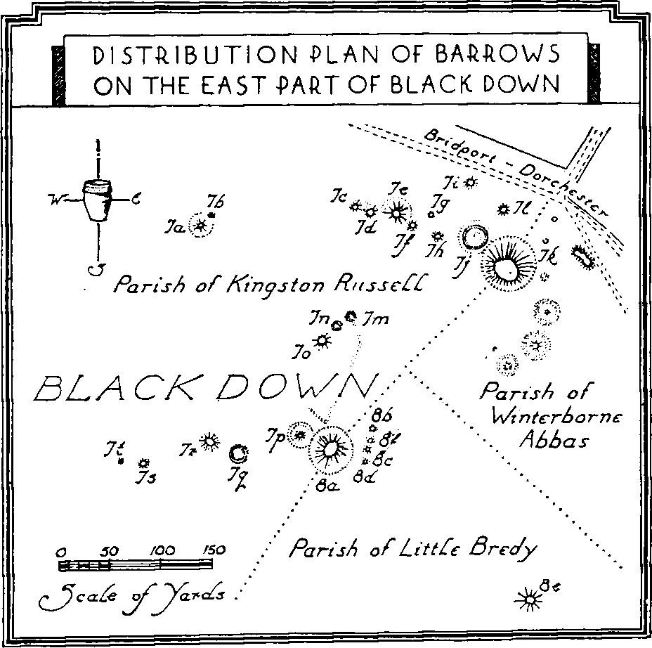
Distribution Plan of Barrows on the East Part of Black Down
b(8) Mounds, about 200 yards S.S.E. of Kingston Russell Farm, are two in number. The more northerly is 35 ft. in diam. and 3½ ft. high; the second, 25 yards to the S.E., is 45 ft. in diam. and 5 ft. high.
b(9) Dyke, extending N.E. across the ridge over ¾ m. E.N.E. of Kingston Russell House, has a ditch on the N.W. side. The bank is about 27 ft. wide and 3 ft. high.
a(10) Dyke, extending a little W. of N. across the ridge about 600 yards W.N.W. of (9), has a ditch on the E. side. The bank is about 12 ft. wide and 1 ft. high. It is now about 90 yards long.
c(11) Lynchets, on a S.E. slope ¼ m. N. of Kingston Russell House, form four terraces.
a(12) Lynchets, on a S.E. slope, immediately N. of (11), form four terraces.
d(13) Lynchets, on the S.E. slope of Whatcombe Down 1,100 yards E.N.E. of Kingston Russell House, form five terraces.
